Hello Grisemote,
Voilà ce que nous avions comme programme en 2 jours plein à
Glacier NP (sorry c'est notre feuille de route en "english" car provient d'un guide "photo" en anglais). 1 bonne journée pour faire la Going to the Sun Road (dodo au Many
Glacier Hotel sur les excellents conseils de Vilcanota

) + 1 journée à Many
Glacier... trop court mais tu prévois d'y passer + de temps, alors enjoy !!
McDonald Lake Turnout North Mac Donald Road => Mac Donald Creek Trail --> Mac Donald Falls (0.25 mile) Stop at the Moose Turnout, just beyond the end of McDonald Lake Upper Mac Donald Creek View Mount Cannon View Avalanche Creek area and a hike along the Trail of the Cedars. Red Rock Point View Heaven’s Peak View Avalanche View
From this point on stop at all the turnouts, for photo or to evaluate the possibilities for later.
(Bird Woman Fall Views, Weeping Wall, Haystack
Bend & parking area, Alpine Meadow...)
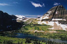
Logan Pass : take the Hidden Lake Trail as far as the overlook.
Stop at the turnoffs along the way down to St. Mary Lake
St. Mary lake: stop at the turnouts at the end of the lake for a view of 100-foot
Virginia Falls across the valley. From the
Virginia Falls turnoff or Sun Point you can take some short hikes.
One is a fork that leads to Sunrift Gorge where a steep, paved path leads to an overlook with windswept pines and views of Baring Creek cascading over slickrock.
Another trail continues around to the end of St. Mary lake and leads to St. Mary and
Virginia Falls. There is an excellent view of St. Mary lake as the trail rounds the lower end of the lake over a bluff. The trail continues to St, Mary Falls and then over a bridge at the base of
Virginia Falls.
For excellent photo views of the lake, take the short spur road to Sun Point and the next turnout. Goose Island View (1.5 miles from Sun Point) is a "must stop." This is one of the most photographed views in the park. The Little Wild Goose island adds to photographs of the lake.
The next turnout, The Narrows, is where the width of the lake is just a quarter mile across. Take the short path to the lake for some outstanding views.
Near the road to the St. Mary campground, you have a good view looking southwest of the lake. Just before the town of St. Mary, a road leads down the east of the lake a short distance to the Eagle Lake Trailhead. This trail takes you through grasslands and aspens and cottonwood groves, and is another good location to photograph St. Mary lake. Mountain goats inhabit Red Eagle Mountain.
Logan Pass-> Hidden Lake (1.5 miles)-> Continental Divide vers Granite Park Chalet 3h A/R
Many
Glacier-> sentier pour Iceberg Lake (rando vers Swiftcurrent pass --> stop au 2ème lac)-> sentier Grinnel
Glacier (on peut aussi traverser le Swiftcurrent Lake et le Josephine Lake en bateau)
Poursuite sur la Chief Mountain Road où l’on rejoint
Waterton Lakes National Park au
Canada (72 km ~ 1 à 2h). Passage de la douane en 2 minutes à peine (personne, douanier sympa...) et je confirme : on avait oublié de passer les miles en km au passage de la frontière
USA/
Canada et du coup on a un peu roulé trop vite

mais ouf pas eu de radar ! Dodo et resto au Kilmorey Lodge (toujours sur les bons conseils de Vilcanota

) : c'était TOP !!!
A Warterton : Akamina Highway +
Red Rock Canyon Parkway + Hôtel Prince of Wales
J'en connais beaucoup moins que Vilcanota, mais si je peux t'aider, n'hésites pas !
@+
Noa




 .
.
 je suis confus de cette méprise, je ne me souvenais plus qu'il s'agissait du sud et non du nord. Bon je pense que je serai pardonné, tu sais l'âge aidant!!!!!