Bonjour
nous voulons faire l'ascension de l'Etna. Avez vous des tuyaux sur ce volcan ? Savez-vous s'il y a camping ou auberge de jeunesse dans le coin. Merci pour vos précieux tuyaux kikis
Bonsoir, n'etant pas revenu sur l'etna depuis 2002 je ne sais si mes infos seront tjrs d'actualités mais à mon dernier passage il était possible de trouver logement au "rifugio sapienza" qui se trouve à 1900 m d'alt', en fait c'est la base d'arrivé qd on monte de Catane ou de Taormina, à cet endroit logements restaurants et boutiques . le mieux à mon avis est de s'arreter à Nicolosis, entre Catane et le rifugio di sapienza, là vs trouverez camping municipale et auberge de jeunesse . A partir du Rifugio di sapienza s'offre à vous l'ascension du volcan, en minibus 4/4 avec guide ou à pieds (2900 m) c'est ce que j'ai fait ! il y a quelques annee un telepherique montait mais détruit par une coulée de lave depuit . voila ...😉
"voyager c'est demander à la distance ce que le temps nous donne peu à peu" ...
L'été dernier, le téléphérique fonctionnait à nouveau pour monter aux alentours de 2500 m.
Du sommet, des 4X4 emmènent les touristes au sommet. Il est aussi possible d'y aller à pied en 2-3 h depuis le sommet du télephérique.
Pour loger, le refuge Sapienza est cher et n'a pas l'air tres sympa.
On dort et mange mieux à Nicolosi mais cela reste assez cher.
tres surpris que le telepherique fonctionne de nouveau ... bonne nouvelle !! c'est vrai sapienza c'est bof bof, l'auberge à touriste ds tte sa spendeur, les boutiques hum hum, j'avais acheter cet alcool el fueco del etna, une bonne colique les jrs suivant, en fouinant un peu, plus bas j'avais degote un bon vieux miel pas degueu ...
"voyager c'est demander à la distance ce que le temps nous donne peu à peu" ...
Bonjour,
Superbe vos photos de votre dernier voyage en Italie.Je suis admiratif car nous avons tenté le "chemin des dieux" en 2006 sur la cote Amalfitaine, mais c'était tellement mal indiqué que nous avons préféré retourné car trop scabreux...impossible de trouver un passage pour redescendre a Positano après 3 heures de marche.
Je pars fin janvier a Syracuse ;je prévois de me rendre a l'Etna .Est il difficile en cette saison de monter au sommet? Avez vous pris un guide?Avez vous certaines recommandations?
Je vous remercie pour votre aide.
JP
Merci Lamarche pour les compliments.
Pour le sentier des dieux, j'avais trouvé ce site qui nous a bien rendu service : http://www.giovis.com/sentdei.htm
Pour l'Etna, j'avais contacté le groupe des guides de l'etna nord : http://www.guidetnanord.com/fr/esc_fisse_01.asp
qui proposait de nous donner un guide pour la journée pour 250 euros. Nous voulions en effet aborder le volcan par son versant nord, plus sauvage. Finalement 3 semaines avant notre départ, ils nous ont envoyé un mail pour dire qu'ils annulaient toutes leurs excursions, je ne sais pas pourquoi, sans doute pour des raisons météo car début décembre a été -je crois- vraiment pourri.
Je n'ai pas cherché à en savoir plus car ils étaient de toute façon très peu réactifs (15 jours pour répondre à mon premier mail et ils ne m'ont jamais dit s'ils louaient des raquettes ou des skis de rando)
La balade (à pied quand pas de neige )est prévue pour durer 6 heures. Vu les conditions quand nous y étions, c'aurait été vraiment pénible par ce côté-là.
Donc par le versant sud, le téléphérique monte à 2500 m.
Le cratère où nous sommes allés (celui accessible légalement aux randonneurs sans guide ) est à 2900 m d'une marche facile à condition, si le terrain est aussi glacé que qd nous y étions, d'avoir des raquettes ou des crampons. Je crois que nous sommes les seuls à avoir pu monter car les autres n'avaient pas ces équipements.
Je regrette de ne pas être allée jusqu'au sommet qui est seulement 400 m + haut (sans autre difficulté apparente que le fait que ça glisse et que nous n'avions que 2 paires de raquettes pour 5 : ça n'aurait pas été prudent).
Mais la balade est déjà superbe même sans aller tout en haut!
Pensez à bien vous habiller, le fond de l'air est très frais et il y a du vent.
Y aller le plus tôt possible car en cours de journée les nuages montent assez rapidement.
Pour être + tranquille, éviter le WE.
Je vous remercie encore pour ces précieux renseignements.Juste quelques questions avant de partir la semaine prochaine:
Est il possible de louer des raquettes sur place?
Le chemin est il bien balisé?
Est il possible de faire du ski?
Je vous remercie encore, mais je ne sais toujours pas comment vous avez peu traversé le chemin des dieux sans problème...Trop risqué par endroit en arrivant sur Positano....que du rocher qui ne demandait qu'a tomber ...
Oui, on doit pouvoir louer des skis et des chaussures à Sapienza. Je crois avoir lu ça dans le Routard.
On peut faire du ski de piste et le domaine n'est pas ridicule du tout, il y a de quoi s'amuser d'autant que le relief est tout en rondeurs et il y a pas mal de possibilité de hors piste "à vue" sur une neige non damée.
Quand nous y étions la qualité de la neige n'était pas extra (gelée, croutée) mais l'environnement est vraiment inhabituel.
Il y a donc le téléphérique (1900 m en bas, 2500 en haut avec une possibilité de forfait ski dont je ne connais pas le prix)
Il y a aussi un télésiège 2 places puis un téléski., tout ça monte un peu moins haut que le téléphérique.
Quand nous y étions il n'y avait (en semaine donc, entre Noel et Nouvel an) vraiment pas gd monde, aucune attente, tous les oeufs quasiment vides (il doit y avoir plus de monde en milieu d'après-midi)J
Pour la location de raquettes, je ne sais pas, nous n'en avons pas vu.
Le chemin est bien balisé par des poteaux de bois qui peuvent être bien utiles en cas de brouillard. Par beau temps il est impossible de se perdre! Pour trouver le départ (non balisé!) il faut monter au-dessus de l'arrivée du téléphérique. Je crois d'ailleurs me rappeler que le balisage avec les poteaux ne débute que plusieurs centaines de mètres après le départ.
Il doit y avoir 2 sentiers : poteaux jaunes et poteaux rouges. En fait s'il fait beau, on trace son chemin selon ses envies, c'est ce que nous avons fait.
J'y pense il y a juste à côté de la cabine de départ du téléphérique une maison des guides qui propose des randonnées accompagnées (n'ouvre je crois qu'à 9h30 ou 10h)
Sans équipement il est de toute façon possible de faire une belle balade sur des pentes assez douces mais en restant en contrebas des cratères.
Pour en revenir au Sentier des Dieux, je me demande si vous étiez bien sur ce fameux sentier. Celui que nous avons suivi était très bien tracé, vraiment sans danger mais nous ne sommes pas allés juqu'à Positano. Nous avons démarré de Bomerano qui est un peu au nord d'Averola et sommes allés vers l'ouest jusqu'à Nocelle.
La seule difficulté a été de trouver le départ du sentier, avec une bonne dose de pif!
N'hésitez pas si vous avez d'autres questions.
Marie
Dernière chose, votre voyage US est sublime!!!vos enfants ont de la chance....Je retourne aux USs en Mai, et votre périple me tente pas mal;avez vous une carte sur votre site avec votre virée??
Non hélas, je n'ai ni carte ni site d'ailleurs. Tout ce que j'ai est dans le carnet de voyage sur VF!
C'est vrai que sur un atlas type Rand Mc Nally on a du mal à avoir une vision d'ensemble.
L'idéal serait de pouvoir suivre sur une carte classique.
Désolée!
Marie
je me greffe sur ce post: nous partons a 4 potes pour grimper sur l'etna mi juin. Par contre, nous partons du jeudi au dimanche, donc nos 2 seuls jours complets sont les vendredi et samedi.
Ma question est la suivante: est il possible d'atteindre le sommet en une journée ? Aucun pb si il faut se lever a 4h du mat, on voudrait faire une marche correcte en non pas monter tout en voiture pour marcher 100m sur le final.
Merci de vos renseignement ! mon voyage au nicaragua m'a donné envie de voir d'autres volcans, on en a un chouette pas trop loin alors voila ! et vive les vols low cost ! 100€ AR grenoble-palerme :)
Si vous êtes bons marcheurs, ça vaut le coup je pense de passer par le nord, c'est plus long mais beaucoup plus sauvage.
En tout cas c'est ce que je ferais si l'enneigement le permet.
Il y a des webcam sur l'Etna qui vous permettront de voir s'il y a encore bcp de neige ou pas.
Dans tous les cas, c'est faisable en un jour sans aucun problème par le sud. En une grande journée par le nord si pas de neige.
Il y a aussi les îles éoliennes avec en particulier Stromboli mais je crois que récemment l'activité du volcan interdisait son ascencion mais 4 j c'est un peu court pour tout faire.
Bonnes balades!
Marie
Bonjour,
Je me greffe sur cette discussion déjà un peu ancienne pour savoir si lors de votre promenade sur le Sentier des dieux, vous aviez une carte, un topoguide ou autre, ou si vous y êtes allés uniquement en suivant les (éventuels ?) balisages.
Merci
Christine
Bonsoir Christine.
Non, nous n'avions rien de tout cela mais nous avions bien cogité à l'avance au moyen de ce site : http://www.giovis.com/sentdei.htm
et avec via michelin et Google Earth.
Le sentier n'offre aucune difficulté si ce n'est de trouver le point de départ car rien n'est indiqué (du moins là où nous sommes partis).
Il faut bien comprendre que le départ est à peu près à mi-pente voire aux 3/4 supérieurs de la côte.
Quand tu arrives à Bomerano en venant du nord (donc en traversant la péninsule) le départ se trouve à l'ouest du village.
Si tu regardes sur via michelin :
cherche Averola,
juste au sud il y a le hameau de Bomerano
avec une rue en épingle à cheveux de grand axe nord sud nommée Via Pendola,
juste au sud de cette rue, tu dois voir sur le plan une rue qui part de la Via Prinicpe di Piemonte, elle va vers l'ouest et se termine en cul de sac.
Le trésor (heu le départ!!) pourrait bien être là en tout cas ç'est au bout d'une rue dans "ce goût-là".
Il y a juste assez de place pour se garer sur le bord de la route et le sentier poursuit la route (mais aucun panneau t'indiquant que tu es bien arrivée)
Vue ! Je vais laisser aux enfants le soin de la trouver "en vrai", ça donnera à cette promenade un petit goût de chasse au trésor qui ne devrait pas leur déplaire...
J'ai vu par ailleurs que tu t'apprêtais à partir pour la Slovénie/Croatie : je vais suivre attentivement ton carnet de voyage (toujours super intéressants, soit dit au passage) dont je pourrais bien m'inspirer pour un prochain voyage.
Encore merci et bonne préparation
Christine
Nous partons pour un tour de Sicile et îles éoliennes le 21 juillet. Quelle ascension privilégier? Etna, Stromboli (ascension possible jusqu à 700 m ou bateau…
Dans un mois j'ai prévu d'aller en vacance en Sicile et aux Iles Eoliennes et de faire l'ascension du Stromboli, du volcan sur Vulcano et aussi de l'Etna.…
Je souhaiterai partir en sicile fin avril ou début mai pour une petite dizaine de jours. A faire de la rando, de la visite et de la farniente... N'hésitez pas…
Nous sommes 2 jeunes femmes sportives, habituées des treks et longues randos. Nous passons une semaine en Sicile début août et nous avons prévu de faire…
Je souhaite voir l'Etna et l'escalader, je ne sais pas quel équipement est nécessaire (chaussures, pull, doudoune...) ni quelle condition physique. nous…
Bonjour,
Nous souhaitons faire le trek de 4 jours reliant Mestia à Ushguli sans agence. Il est précisé dans les descriptifs qu'il existe des hébergement à chaque étape, mais on ne trouve pas d'info sur ces hébergements. Quelqu'un a-t-il des infos et un avis sur ce parcours?
We're planning to trek in Peru and Bolivia and would love to find some local agencies.
If you know any, could you share details on prices and, of course, the names of the agencies?
Which trek would you recommend?
Elocine
Je pars en autonomie totale sur un trek au Maroc (10jrs) Imilchil - Aghbalou.
Trouve t-on des cartouches gaz à vis (Coleman, Primus) à Marrakech (adresse) ou villages entre Imilchil - Aghbalou ?
Si non , trouve-t-on des cartouches Butagaz pour camping-gaz (petit volume 230 gr ...)
Merci d' avance pour vos réponses
Hello, I’d like to embark on a little trip in my home country, Switzerland. I’ll start walking from La Cure, heading toward Le Noirmont first, then I’ll improvise my route—but it’ll probably follow the French border... at least as far as Lac de Joux.
I’ll decide day by day how much farther to go after that. My goal is to stay in nature as much as possible, wander around for as long as I can, and restock food in villages or towns along the way.
I’m thinking of mostly camping, but we’ll see if I end up in a hotel or another campsite depending on my route.
I’d love to reach La Chaux-de-Fonds on foot... maybe even Delémont.
The whole thing should take about a week, give or take.
I’ll be bringing my dog, and I’m preparing for this as soon as I’m ready.
Any tips to make sure everything goes smoothly for us? Things I should know—or avoid? What about shepherds with their flocks of sheep? And isn’t hunting season open right now?
I’m not sure if what I’m planning is even doable, which is why I’m asking around.
This’ll be my first time doing something like this—wandering in nature *and* with a dog. I’m really excited for this adventure... and I need it. Thanks!
We’re really keen on ecosystems and want to hike in "natural" ancient forests—not planted woods or areas heavily degraded by human activity. Travel guides (like Lonely Planet) don’t provide much info on this. Could you point us to the most interesting spots?
Thanks in advance for your tips.
We wish you happy holidays and a fantastic 2026, full of discoveries!
Claire and Albert
Hi, this might not be the right section, but I’d like to know if it’s possible to start mountaineering with another person without necessarily hiring a guide. We’ve done quite a bit of hiking but not mountaineering—we’ll just do a half-day glacier course. After that, we were thinking of starting with La Grande Motte and the Pointe de la Traversière, which were recommended to us. Honestly, for things like roping up and knots, I’ll learn at home with lots of videos and a book.
Hi,
I don’t know Switzerland at all and was wondering if Vallée des Joux and especially Dent de Vaulion are packed early in the morning or late in the afternoon in July and September?
If so, do you have any quieter spots to recommend in the area, or in Luxembourg (yes, I know it’s not the same country 😉)?
Thanks a lot!
Jaimerais savoir si quelqu'un aurait fait des treks sur le Ruwenzori et combien ça coute en moyenne, les infrastructures, les paysages la sécurité sur les lieux, merci beaucoup. J'attends avec impatience vos réponses.
We’re leaving in 9 days for a two-week trip to Madeira, mainly to hike.
From my research, I’ve found that since last year, access to most trails—and systematically for the most popular ones—is now paid. You have to pay an access fee of 4.50 € per person per classified hike in 2026, and even 10.50 € for the most iconic hike: Pico Arieiro to Pico Ruivo. When paying, you also have to choose a day and a 30-minute time slot for your start time. Of course, this reservation is neither changeable nor refundable, even if the weather that day is terrible.
Personally, given the massive influx of tourists to the island in recent years, I don’t mind paying a fee to help maintain the trails. Similarly, setting a limit on the number of people who can hike them per day is certainly preferable to preserve this priceless heritage.
However, what’s much less fair is that in reality, most of the available spots are reserved: 1/ for Madeira residents (which is normal); 2/ for "economic operators" (meaning local tour operators). For example, if you’re a non-resident (independent tourist), no booking is possible for the Pico Arieiro hike for an early morning start before September! So, unfortunately, we’ll have to skip this hike.
It’s the same issue for Ponta de São Lourenço, the 25 Fontes, Pico Ruivo... in short, all the most popular hikes. Oh well, we’ll skip those too!
So my question is: which hikes do you recommend where we won’t face the huge crowds that the others get? And where we can book the day before for the next day, taking the weather into account?
Finally, a quick accommodation question: we’ve booked the first week in Funchal, but I haven’t decided yet for the second week. Do you have any advice on where to stay in the south or north, preferably avoiding overly concrete-heavy and touristy spots?
I’m reposting about the logistics for Samaria Gorge.
I’d love to get recent info, especially about whether it’s possible to park my car in Omalos, do the hike, and then catch a bus back to my vehicle.
In theory, it’s doable, but when you check the KTEL website, there aren’t any feasible schedules listed. If anyone has recently organized this with reliable, verified details, I’d really appreciate it. Thanks in advance!
Hi there,
We’re flying from Montreal to Lyon this August to go hiking in the French Alps. We’ve rented a car and will be staying at campgrounds. We’re planning to do day hikes and want to stay a few days in one spot, do a few hikes, then move on to our next camping spot. Could you share your favorite spots or any recommendations for places to spend a few days with great hikes?
A few details:
We arrive in early August and leave in early September.
We’re looking for day hikes (or shorter), moderate difficulty, with a cumulative elevation gain of no more than 1000m, and of course, beautiful scenery!
We’d prefer not to drive too much—maybe it’s best not to head too far south and deal with unnecessary heat?
Along the same lines, if you know of any great campgrounds where we can start our hike directly without needing the car, we’d love to hear your suggestions!
Bonjour
Souhaitant faire de la randonnée sur cette île, je voudrais d'abord savoir quelle serait la période la plus favorable sachant que j'avais passé quelques jours en novembre 2018 pas pour cette activité mais plus pour une simple découverte de l'île et le temps n'était pas top notamment en montagne. Donc peut on choisir une organisation en étoile sachant que je louerai un véhicule avec éventuellement 2 points d'hébergement.
Je n'envisage pas d'intégrer une structure mais de partir à 2 et de s'organiser sauf si vous me conseillez une agence locale ou un guide local. Enfin même si je compte me procurer les différents supports, carte et topo guide plus gps je vous remercie de bien vouloir me communiquer les randos à faire en priorité
Merci beaucoup pour vos informations
I’m planning to do the Mercantour crossing following the Randoxygène route in mid-July.
I’m used to hiking in the mountains, but I sometimes get vertigo, for example on ridges with drops on both sides. I wanted to check if there are any T4 or T3-T4 sections and find out if there are any very exposed passages—and if so, where—so I can plan an alternative route.
Can anyone give me some info on this?
Thanks!
I’m planning a trip around Cap Corse and the AGRIATES in 2026, from May 8th to 15th (there are still 2 spots left, by the way! Just DM me if you're interested).
I’d love to know which hikes are worth prioritizing in the AGRIATES. We’ll be staying in SALECCIA for two days as our base—what should we focus on from there?
A round trip to IGNHU beach? Any other suggestions?
For Ostricano, I think it’s too far for a round trip...
Thanks for your tips!
Have a great day,
Anie, Toulouse
I’d like to get some info about the GR10 Pyrenees traverse. I need help planning the daily stages and accommodations—my wife isn’t an experienced hiker but walks a lot, so I’d like to schedule shorter walking days and thus a longer overall trip in terms of number of days.
Could anyone give me some help and advice?
Best regards,
New to this forum, I’m planning a pretty big project for 2028.
I’m heading to Nepal to do a trek from Kathmandu all the way to Everest Base Camp (a cool 5,300 m 😄).
This trek is a bit special because even though I’ll be part of a group, I’m going solo (so far, no problem—I’m used to it). But it’s my first real trek, and it’s also a humanitarian one: once I reach base camp, I’ll stay an extra week to help clean up the waste left by tens of thousands of climbers! Since I’m originally from South America, from two countries that share the Andes, I have a deep respect for mountains—they fascinate me. So Everest… it’s kind of the trip of a lifetime!
So, a little question for those who’ve done treks to Everest before… any tips for good mental preparation (I’m already working on the physical side)?
Hi there, I’m planning the Annapurna Circuit for March 2027 and I’m looking for a local agency with a local guide—preferably French-speaking—to arrange this trek for us. Any suggestions? Thanks
Hello!
We’re spending a few days in Toraja country at the end of May. We’d love to do a day trek—taking our time—on a route that’s stunning in terms of scenery, but not a level 5 in difficulty!
Any suggestions you can share, please?
Thanks in advance
I’d like to do the Mare a Mare Sud in May over 4 days. I’ve found quite a few places to stay along the route, but I’m stuck on the start and finish.
I’ll be arriving by plane on Sunday evening and would like to start pretty early on Monday morning. Ideally, accommodation right at the trailhead (Alzu di Gallina) would be amazing, but I can’t find anything. Any tips?
Also, for the transfer from Figari Airport to Porto Vecchio or Alzu di Gallina?
At the end, I’d like to pick up a rental car—any advice on that too?
I’m traveling solo by plane to Catania in May and plan to hike the northern side of Etna, starting from Linguaglossa where I’ll arrive by bus. After that, I’d love some info on how to get up to Piano Provenzana (shuttles or hitchhiking), since it seems there’s no public transport except in the summer. Can you sleep there in a free or cheap refuge, or camp? And how far up can you go without having to hire a guide? Thanks in advance. Bernard.
Bonjour a tous,
je pars en voyage au Maroc en aout et nous allons commencer par nous arrêter a Chefchaouen(nous sommes en voiture).
Ma question: quelqu'un peut il m'indiquer un itinéraire de rando en boucle d'entre 5 et 7 jours aux départ de Chefchaouen dans le parc de Talassemtane passant si possible par le pont de dieux?Ou un guide papier qui en reunis quelques uns?
Nous privilégions le camping sauvage et les gites.
Merci d'avance
Hi there, for those who’ve been recently—is it possible to find other solo travelers in March on the island to share transport or room costs? It doesn’t seem easy to travel on a budget.
If you have any recommendations for simple lodgings or places with dorms, I’d love to hear them.
For those who’ve done multi-day treks while moving around: do you need to bring your own sleeping bag? I’d love to hear about itineraries you’ve done without a guide, just with a map and GPS.
Thanks, and have a great day!
Hi everyone!
We’re planning a 15-day road trip to Scotland this summer, specifically to explore and hike on Lewis and Harris—places we’ve never been before. We’ve visited other islands on previous road trips in Scotland (we usually go in April for a week). This would be our first time in Scotland in the summer and for 15 days. We’re looking at late August to early September.
I’m currently drafting the itinerary. We’d be crossing from Ullapool and were thinking of spending 3 nights on Harris and 4 nights on Lewis.
Does that sound balanced to you? Is it better to keep the same accommodation on Harris and the same on Lewis to explore the area? I’d love to hear about any past experiences you’ve had on these islands.
Thanks!
Hi there, I’m trying to leave for 15 days very soon to São Vicente. I’m either looking to join an agency or figure things out on my own to go hiking on one of these islands or both. From what I’ve seen, it’s not easy to organize with local transport, so it gets expensive. Can I use the services of a small local agency? I’m looking for the simplest way to hike for several days. Also, how do you get from São Vicente to São Nicolau? Thanks in advance and have a great day!
Aichatou
I’ve been wanting to do this for several years, and this year’s the one. Next September, I’ll be trekking in Tusheti (Georgia), from Omalo to Shatili.
Of course, I won’t be renting a vehicle that’d just sit unused. No problem getting to Pshaveli, but from there to Omalo, it’s a dirt road (still the case?)
There must be some form of public transport since there are so many guesthouses, and not all travelers come in a 4x4.
If any of you have been to Omalo, could you confirm that these shared transports exist and how often they run?
we’re planning a trip to Yellowstone and hoping to do a three-day backcountry hike if we get a permit.
if any of you have done this before, could you let me know if it’s possible to find water along the way? And if we can transport it, are we allowed to use a stove?
Hello,
I’ll be in Nepal from March 6th to 29th (we’re flying into Kathmandu via Varanasi and leaving via Delhi).
I’m a bit confused about the regulations requiring a guide.
My wife and I (we’re 63 and 64) aren’t experienced trekkers—we’re more used to walking on terrain with very moderate elevation changes. I’m looking for fairly easy hikes, possibly day trips.
Here are my questions:
- Does the Poon Hill trek from Pokhara require a guide, or is it better to go through a local agency? (I’ve seen a lot of them offering 4-day packages)
- I’d like to do a few multi-day hikes around Jomsom (Kagbeni, Mukitinath, Lupra, Marpha)... Do you need a guide for those, and can you find accommodations easily without booking in advance?
Last question—I’m really hesitant to lug around a sleeping bag or down jacket during our 6 weeks in India. Can you easily find these kinds of items at reasonable prices in Pokhara?
Thanks in advance for any tips you can share!
Yann

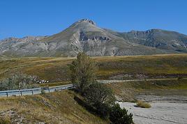 L’Abruzzo, une région qui mérite d’être découverteFR
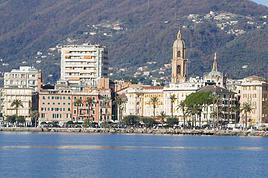 Jour de l'An sur la côte LigureFR
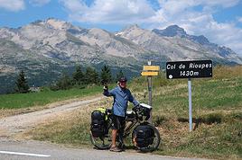 Un petit tour de chauffe à vélo dans les Alpes françaises et italiennesFR
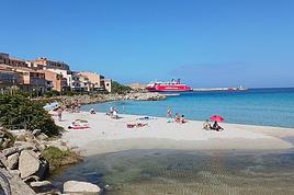 A "relaxed" 16-day tour of Corsica in autumn 2024
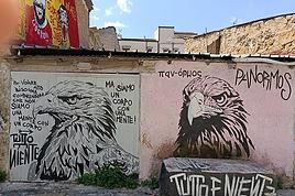 Palermo street art
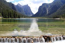 Trois semaines en Italie entre les Dolomites et VéroneFR
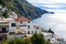 Balade amalfitaineFR