Sans prendre l’avion il faut prendre le bus de katmandou pour Jiri ou le village suivant qui est Shivalaya.
Cout 740 roupies et entre 7 et 10 h de routes dans un bus bien rempli.
De Shivalaya à Namche il faut compter 4 à 6 jours (Pour moi 6 à l’aller et 4 au retour).
Après on retrouve le chemin rempli de touriste … pas trop la 1ere quinzaine d’octobre.
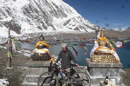
Je suis passé par le Kala Patar qui offre une très belle vue à 5545 m et le camp de base de l’everest (où l’on ne voit pas l’everest).
Direction ensuite le chola pass pour rejoindre Gokio et ses très beaux lacs. L’ascension du Gokio Ri offre une vue encore plus panoramique que le Kala Patar. Encore un pass le Renjo qui offre encore de belles vues avec le 3eme lac de Gokio.
Retour sur Thame et Namche après cela et descente à Shivalaya.
Prix des hébergements : de gratuit à 100 par personne et ce quel que soit l’endroit (meme quand on monte en altitude).
Nourriture : les prix grimpent ici avec l’altitude car il faut bien payer les porteurs.
Prix au départ de Shivalaya 250 rps pour un dal bhat et 100 pour un muesli avec lait contre 600 pour un dal bhat tout en haut et environ 400 pour le meme muesli (et parfois les portions se réduisent)
Je n’ai pris ni guide ni porteur. Le chemin est vraiment facile à suivre il peut y avoir quelque doute au début mais il suffit de demander (tout le monde ou presque parle anglais).
Pas de porteur car pas besoin de grand sac. J’ai voyagé avec un gars qui devait avoir 6 kg d’affaire. Pas de sac de couchage car on peut toujours demander une couverture de plus (moi j’avais pris le mien je l’ai utilisé car je l’avais avec). Pour les vetements il fait beau en journée donc je marchais en t-shirt et pantalon. J’avais 3 t-shirt 2 polaires et une veste pour la pluie et quelques paires de chaussettes. Facile de nettoyer et faire sécher ses affaires quand on marche.
Prévoir de bonnes chaussures et une paire de lunettes de soleil ainsi que de la creme. Des gants aussi et un bonnet pour les frileux.
On peut charger ses batteries à peu près partout à condition de payer. Pour l’eau prévoir un filtre ou des pastilles ou de l’argent si on veut acheter de l’eau en bouteille (100 à namche et plus cher encore après). Personnellement je bois l’eau directement des cascades ou rivières. Du moment que l’eau est en mouvement.
A namche et dans d’autres villages on trouve de tout ; nourriture chaussures et autres equipements de trek. Il y a un dab et des bureaux de change.
23 jours de trek pour moi et il y a beaucoup de touriste la deuxième quinzaine. Certains lodges sont complet assez vite. J’ai vu quelques tentes. Je n’ai pas trop compris car ce n’est pas gratuit et le logement ne coute rien. Et c’était bien des tentes de touristes.
Certaines parties (hors du circuit classique) nécessite une tente mais pas si c’est votre première fois et que vous restez dans le circuit tradionnel. On peut acheter une carte à Katmandou. Entre 250 et 450 rps la carte. Elle ne vous aidera pas à vous orienter car il n’y a pas beaucoup de détail. Intéressant pour savoir où l’on est et où l’on va. Mais encore une fois c’est très facile … encore plus si vous commencez de Lukla.
La 1ere partie de Jiri à Namche est assez dure à cause des très important dénivelés. Montée de 2000 et descente de 1000 … bref de quoi s’entrainer.
Plus de détail sur mon blog et si vous avez des questions n’hésitez pas j’essaierais de vous répondre.
Cout des permis et entrée de parc que l'on peut faire à Katmandou ou sur la route.
1er parc 2000, 2eme parc 3000 et le tims 2000 roupies
Salut Mellone
Merci pour ton post, pour moi ça sera d'actualité semaine prochaine!!!
je pars dimanche pour le Népal , objectif le Kala Patar en partant de Jiri et retour par Lukla !
mais tes info sont très importantes et je vais peut-être revoir mon itinéraire, si tu peux me donner qques infos .
Arriver à Shivalaya permet de gagner 3h ! peux tu me dire quelles ont été tes étapes pour rejoindre Namche ?
J'avais prévu de 0 à 3 jours d'attente à Lukla Mais en refaisant mon plan , je peux passer par le Cho la et le Rencho La et ensuite redescendre en 4 jours sur Shivalaya ……super !! comment sont les pass ? en neige? verglas ?
Comme toi je marche en solo et léger, MERCI pour tes info à venir …. si tu as un peu de temps à me consacrer !! lol
Salut Claude
Le bus arrive en fin d'après midi à Shivalaya donc le 1er jour tu ne pourras pas marcher. Pour rejoindre Namche en 4 jours ca risque d'etre dur surtout de ce coté, cela dépend de ton rythme]
Pour l'aller on était à 3 et on a mis 6 jours sachant que l'on perd beaucoup de temps si on s'arrete pour le lunch a midi. Le temps d'allumer le feu, de cuisiner et de manger ca prend entre 1h et 1h30. Sur le retour je ne m'arretais pas pour le lunch.
Les étapes :
Kenja juste avant la montée de 2000 m. Si tu peux arriver à Sete c'est mieux tu couperas cette montée en 2 jours.
2eme jour : Juste avant le pass
3eme : ringmu
4eme : kharikola
5eme jour : sur le chemin qui permet d'éviter de passer par lukla mais je ne me rappele plus le nom du village
et ensuite Namche.
Les pass étaient très enneigés mais le passage ouvert donc pas de problème mais le temps a évolué depuis donc impossible à dire pour la semaine prochaine. Je te conseille d'aller en premier sur l'ebc et kala patar et si tu peux prendre le pass cho la (plus facile de ce coté) et ensuite rejoindre gokyo et passer le pass renjo toujours si le temps le permet. Si tu viens de l'autre coté et que le temps est mauvais tu devras redescendre pour aller au ebc
Bonne route
francois
ps : je pars demain au langtang donc si tu as d'autres questions je ne pourrais pas répondre désolé
Je suis de la réunion et je compte faire ce trek en octobre ( mi octobre) , peux-tu me dire à quelle période tu as fait ce trek et si on peut le faire sans agence
Merci
pas de problème pour le faire en octobre. Début c'est mieux car moins de touristes.
Aucune obligation de passer par une agence, il faut juste acheter le tims et permis par vous meme à katmandou ou sur le chemin
Merci François pour tes info
En 6 jours ça risque d'être "chaud"…. je verrai sur place !
bon trip dans le Langtang ( un bon souvenir d'il y a qques années !)
Salut
Claude
PS : autre info , trouve t'on des guesthouses tout lelong du parcours , surtout manger qques choses le midi , Merci.
Petite remarque sur la partie Jiri/namche.
La difficulté principale est la somme importante de dénivellés sur cette portion de trek - en gros +1000m / -1000m par jour.
Il est (toujours) possible d'aller "plus" vite en évitant de marcher plus vite et en marchant plus longtemps.
Je pense toutefois que le passage du col principal (le Lamjura) à 3400m est difficile dans la journée (+2000m de Kinja) et qu'un arrêt à Sete est si ce n'est nécessaire, important.
Sur la 2e partie, il n'est absolument pas nécessaire de passer par Lukla,
Il faut aussi savoir (mais c'est indiqué précédemment) qu'il y a beaucoup de possibilités d'hébergements sur ce trek (toutes les heures environ).
proposition : Jiri/Déorali - Déo/Sete - Sete/panorama (2h après jumbesi). pour la suite, le faire en 3 ou 4 jours est possible.
Je prépare le trek everest base camp par les lacs Gokyo en novembre prochain. nous partons en individuel (vol sec) j'ai trouvé beaucoup de réponses à mes…
Je pars avec mon amie en octobre prochain au Népal pour la première fois:) Je compte faire le trek des 3 cols du camp de base de l'Everest en 18j sur place…
Pouvez-vous me dire exactement quels sont les formalités pour faire le trek du Camp de base de l'Everest (TIMS-Droits d'entrée-passeport-p... Je sais que cette…
Nous partons à 2, en novembre prochain, faire le trek du camp de base de l'Everest par les lacs Gokyo, en autonomie: pas de guide ni de porteurs par choix! Je…
Je souhaite faire un trek au mois d, avril pour le camp de base de l'Everest (plus détour par les lacs Gokyo). J'arrive a Katmandou le 2 avril et je pars pour…
Hi,
We’re planning to do the 4-day trek from Mestia to Ushguli without an agency. The descriptions mention that there are accommodations at each stop, but we can’t find any details about them. Has anyone got info or feedback on this route?
We're planning to trek in Peru and Bolivia and would love to find some local agencies.
If you know any, could you share details on prices and, of course, the names of the agencies?
Which trek would you recommend?
Elocine
Je pars en autonomie totale sur un trek au Maroc (10jrs) Imilchil - Aghbalou.
Trouve t-on des cartouches gaz à vis (Coleman, Primus) à Marrakech (adresse) ou villages entre Imilchil - Aghbalou ?
Si non , trouve-t-on des cartouches Butagaz pour camping-gaz (petit volume 230 gr ...)
Merci d' avance pour vos réponses
Hello, I’d like to embark on a little trip in my home country, Switzerland. I’ll start walking from La Cure, heading toward Le Noirmont first, then I’ll improvise my route—but it’ll probably follow the French border... at least as far as Lac de Joux.
I’ll decide day by day how much farther to go after that. My goal is to stay in nature as much as possible, wander around for as long as I can, and restock food in villages or towns along the way.
I’m thinking of mostly camping, but we’ll see if I end up in a hotel or another campsite depending on my route.
I’d love to reach La Chaux-de-Fonds on foot... maybe even Delémont.
The whole thing should take about a week, give or take.
I’ll be bringing my dog, and I’m preparing for this as soon as I’m ready.
Any tips to make sure everything goes smoothly for us? Things I should know—or avoid? What about shepherds with their flocks of sheep? And isn’t hunting season open right now?
I’m not sure if what I’m planning is even doable, which is why I’m asking around.
This’ll be my first time doing something like this—wandering in nature *and* with a dog. I’m really excited for this adventure... and I need it. Thanks!
We’re really keen on ecosystems and want to hike in "natural" ancient forests—not planted woods or areas heavily degraded by human activity. Travel guides (like Lonely Planet) don’t provide much info on this. Could you point us to the most interesting spots?
Thanks in advance for your tips.
We wish you happy holidays and a fantastic 2026, full of discoveries!
Claire and Albert
Hi, this might not be the right section, but I’d like to know if it’s possible to start mountaineering with another person without necessarily hiring a guide. We’ve done quite a bit of hiking but not mountaineering—we’ll just do a half-day glacier course. After that, we were thinking of starting with La Grande Motte and the Pointe de la Traversière, which were recommended to us. Honestly, for things like roping up and knots, I’ll learn at home with lots of videos and a book.
Hi,
I don’t know Switzerland at all and was wondering if Vallée des Joux and especially Dent de Vaulion are packed early in the morning or late in the afternoon in July and September?
If so, do you have any quieter spots to recommend in the area, or in Luxembourg (yes, I know it’s not the same country 😉)?
Thanks a lot!
Jaimerais savoir si quelqu'un aurait fait des treks sur le Ruwenzori et combien ça coute en moyenne, les infrastructures, les paysages la sécurité sur les lieux, merci beaucoup. J'attends avec impatience vos réponses.
We’re leaving in 9 days for a two-week trip to Madeira, mainly to hike.
From my research, I’ve found that since last year, access to most trails—and systematically for the most popular ones—is now paid. You have to pay an access fee of 4.50 € per person per classified hike in 2026, and even 10.50 € for the most iconic hike: Pico Arieiro to Pico Ruivo. When paying, you also have to choose a day and a 30-minute time slot for your start time. Of course, this reservation is neither changeable nor refundable, even if the weather that day is terrible.
Personally, given the massive influx of tourists to the island in recent years, I don’t mind paying a fee to help maintain the trails. Similarly, setting a limit on the number of people who can hike them per day is certainly preferable to preserve this priceless heritage.
However, what’s much less fair is that in reality, most of the available spots are reserved: 1/ for Madeira residents (which is normal); 2/ for "economic operators" (meaning local tour operators). For example, if you’re a non-resident (independent tourist), no booking is possible for the Pico Arieiro hike for an early morning start before September! So, unfortunately, we’ll have to skip this hike.
It’s the same issue for Ponta de São Lourenço, the 25 Fontes, Pico Ruivo... in short, all the most popular hikes. Oh well, we’ll skip those too!
So my question is: which hikes do you recommend where we won’t face the huge crowds that the others get? And where we can book the day before for the next day, taking the weather into account?
Finally, a quick accommodation question: we’ve booked the first week in Funchal, but I haven’t decided yet for the second week. Do you have any advice on where to stay in the south or north, preferably avoiding overly concrete-heavy and touristy spots?
I’m reposting about the logistics for Samaria Gorge.
I’d love to get recent info, especially about whether it’s possible to park my car in Omalos, do the hike, and then catch a bus back to my vehicle.
In theory, it’s doable, but when you check the KTEL website, there aren’t any feasible schedules listed. If anyone has recently organized this with reliable, verified details, I’d really appreciate it. Thanks in advance!
Hi there,
We’re flying from Montreal to Lyon this August to go hiking in the French Alps. We’ve rented a car and will be staying at campgrounds. We’re planning to do day hikes and want to stay a few days in one spot, do a few hikes, then move on to our next camping spot. Could you share your favorite spots or any recommendations for places to spend a few days with great hikes?
A few details:
We arrive in early August and leave in early September.
We’re looking for day hikes (or shorter), moderate difficulty, with a cumulative elevation gain of no more than 1000m, and of course, beautiful scenery!
We’d prefer not to drive too much—maybe it’s best not to head too far south and deal with unnecessary heat?
Along the same lines, if you know of any great campgrounds where we can start our hike directly without needing the car, we’d love to hear your suggestions!
Bonjour
Souhaitant faire de la randonnée sur cette île, je voudrais d'abord savoir quelle serait la période la plus favorable sachant que j'avais passé quelques jours en novembre 2018 pas pour cette activité mais plus pour une simple découverte de l'île et le temps n'était pas top notamment en montagne. Donc peut on choisir une organisation en étoile sachant que je louerai un véhicule avec éventuellement 2 points d'hébergement.
Je n'envisage pas d'intégrer une structure mais de partir à 2 et de s'organiser sauf si vous me conseillez une agence locale ou un guide local. Enfin même si je compte me procurer les différents supports, carte et topo guide plus gps je vous remercie de bien vouloir me communiquer les randos à faire en priorité
Merci beaucoup pour vos informations
I’m planning to do the Mercantour crossing following the Randoxygène route in mid-July.
I’m used to hiking in the mountains, but I sometimes get vertigo, for example on ridges with drops on both sides. I wanted to check if there are any T4 or T3-T4 sections and find out if there are any very exposed passages—and if so, where—so I can plan an alternative route.
Can anyone give me some info on this?
Thanks!
I’m planning a trip around Cap Corse and the AGRIATES in 2026, from May 8th to 15th (there are still 2 spots left, by the way! Just DM me if you're interested).
I’d love to know which hikes are worth prioritizing in the AGRIATES. We’ll be staying in SALECCIA for two days as our base—what should we focus on from there?
A round trip to IGNHU beach? Any other suggestions?
For Ostricano, I think it’s too far for a round trip...
Thanks for your tips!
Have a great day,
Anie, Toulouse
I’d like to get some info about the GR10 Pyrenees traverse. I need help planning the daily stages and accommodations—my wife isn’t an experienced hiker but walks a lot, so I’d like to schedule shorter walking days and thus a longer overall trip in terms of number of days.
Could anyone give me some help and advice?
Best regards,
New to this forum, I’m planning a pretty big project for 2028.
I’m heading to Nepal to do a trek from Kathmandu all the way to Everest Base Camp (a cool 5,300 m 😄).
This trek is a bit special because even though I’ll be part of a group, I’m going solo (so far, no problem—I’m used to it). But it’s my first real trek, and it’s also a humanitarian one: once I reach base camp, I’ll stay an extra week to help clean up the waste left by tens of thousands of climbers! Since I’m originally from South America, from two countries that share the Andes, I have a deep respect for mountains—they fascinate me. So Everest… it’s kind of the trip of a lifetime!
So, a little question for those who’ve done treks to Everest before… any tips for good mental preparation (I’m already working on the physical side)?
Hi there, I’m planning the Annapurna Circuit for March 2027 and I’m looking for a local agency with a local guide—preferably French-speaking—to arrange this trek for us. Any suggestions? Thanks
Hello!
We’re spending a few days in Toraja country at the end of May. We’d love to do a day trek—taking our time—on a route that’s stunning in terms of scenery, but not a level 5 in difficulty!
Any suggestions you can share, please?
Thanks in advance
I’d like to do the Mare a Mare Sud in May over 4 days. I’ve found quite a few places to stay along the route, but I’m stuck on the start and finish.
I’ll be arriving by plane on Sunday evening and would like to start pretty early on Monday morning. Ideally, accommodation right at the trailhead (Alzu di Gallina) would be amazing, but I can’t find anything. Any tips?
Also, for the transfer from Figari Airport to Porto Vecchio or Alzu di Gallina?
At the end, I’d like to pick up a rental car—any advice on that too?
I’m traveling solo by plane to Catania in May and plan to hike the northern side of Etna, starting from Linguaglossa where I’ll arrive by bus. After that, I’d love some info on how to get up to Piano Provenzana (shuttles or hitchhiking), since it seems there’s no public transport except in the summer. Can you sleep there in a free or cheap refuge, or camp? And how far up can you go without having to hire a guide? Thanks in advance. Bernard.
Bonjour a tous,
je pars en voyage au Maroc en aout et nous allons commencer par nous arrêter a Chefchaouen(nous sommes en voiture).
Ma question: quelqu'un peut il m'indiquer un itinéraire de rando en boucle d'entre 5 et 7 jours aux départ de Chefchaouen dans le parc de Talassemtane passant si possible par le pont de dieux?Ou un guide papier qui en reunis quelques uns?
Nous privilégions le camping sauvage et les gites.
Merci d'avance
Hi there, for those who’ve been recently—is it possible to find other solo travelers in March on the island to share transport or room costs? It doesn’t seem easy to travel on a budget.
If you have any recommendations for simple lodgings or places with dorms, I’d love to hear them.
For those who’ve done multi-day treks while moving around: do you need to bring your own sleeping bag? I’d love to hear about itineraries you’ve done without a guide, just with a map and GPS.
Thanks, and have a great day!
Hi everyone!
We’re planning a 15-day road trip to Scotland this summer, specifically to explore and hike on Lewis and Harris—places we’ve never been before. We’ve visited other islands on previous road trips in Scotland (we usually go in April for a week). This would be our first time in Scotland in the summer and for 15 days. We’re looking at late August to early September.
I’m currently drafting the itinerary. We’d be crossing from Ullapool and were thinking of spending 3 nights on Harris and 4 nights on Lewis.
Does that sound balanced to you? Is it better to keep the same accommodation on Harris and the same on Lewis to explore the area? I’d love to hear about any past experiences you’ve had on these islands.
Thanks!
Hi there, I’m trying to leave for 15 days very soon to São Vicente. I’m either looking to join an agency or figure things out on my own to go hiking on one of these islands or both. From what I’ve seen, it’s not easy to organize with local transport, so it gets expensive. Can I use the services of a small local agency? I’m looking for the simplest way to hike for several days. Also, how do you get from São Vicente to São Nicolau? Thanks in advance and have a great day!
Aichatou
I’ve been wanting to do this for several years, and this year’s the one. Next September, I’ll be trekking in Tusheti (Georgia), from Omalo to Shatili.
Of course, I won’t be renting a vehicle that’d just sit unused. No problem getting to Pshaveli, but from there to Omalo, it’s a dirt road (still the case?)
There must be some form of public transport since there are so many guesthouses, and not all travelers come in a 4x4.
If any of you have been to Omalo, could you confirm that these shared transports exist and how often they run?
we’re planning a trip to Yellowstone and hoping to do a three-day backcountry hike if we get a permit.
if any of you have done this before, could you let me know if it’s possible to find water along the way? And if we can transport it, are we allowed to use a stove?
Hello,
I’ll be in Nepal from March 6th to 29th (we’re flying into Kathmandu via Varanasi and leaving via Delhi).
I’m a bit confused about the regulations requiring a guide.
My wife and I (we’re 63 and 64) aren’t experienced trekkers—we’re more used to walking on terrain with very moderate elevation changes. I’m looking for fairly easy hikes, possibly day trips.
Here are my questions:
- Does the Poon Hill trek from Pokhara require a guide, or is it better to go through a local agency? (I’ve seen a lot of them offering 4-day packages)
- I’d like to do a few multi-day hikes around Jomsom (Kagbeni, Mukitinath, Lupra, Marpha)... Do you need a guide for those, and can you find accommodations easily without booking in advance?
Last question—I’m really hesitant to lug around a sleeping bag or down jacket during our 6 weeks in India. Can you easily find these kinds of items at reasonable prices in Pokhara?
Thanks in advance for any tips you can share!
Yann