Bonjour,
Nous rejoignons le Népal début octobre pour faire le tour du Dhaulagiri puis rejoindre le lac Tilicho à partir de Marpha. Deux questions restent en suspens:
1) jusqu'où vont aujourd'hui les jeeps ou bus dans la vallée vers Darbang à partir de Beni?
2) Toutes les descriptions lues jusqu'à présent pour rejoindre le lac Tilicho partent de Manang, pour des raisons d'acclimatation probablement. Quelqu'un connait-il la voie contraire partant de Jomosom ou de sa région en passant par Kaisang avec un éventuel repérage GPS?
Merci à l'avance
Question 1:
... jusqu'à Darbang. Au delà, l'itinéraire du tour du Dhaulagiri emprunte un pont suspendu que les véhicules à 4 roues ne peuvent pas emprunter. Je précise que l'info date du novembre 2012 et qu'elle est donc récente (...les choses evoluent parfois assez vite...).
Vous pouvez naturellement prendre un des bus qui font l'aller/retour Beni-Darbang en route mais le chemin Beni-Darbang n'est pas foncièrement désagréable même si y'a mieux que de se faire doubler par des bus & 2 routes sur une route poussiéreuse. Personnellement, j'ai préféré le plaisir de la marche au bus et j'ai compensé le déplaisir de croiser des vehicules motorisés avec le soleil, la vue sur les magnifiques rizieres et les delicieuses babanes que j'ai acheté en route 🙂
Quelques photos de la section Beni-Darbang:
http://4.bp.blogspot.com/...g/s1600/IMG_6264.jpghttp://1.bp.blogspot.com/...A/s1600/IMG_6265.jpghttp://1.bp.blogspot.com/...o/s1600/IMG_6268.jpg
Question 2:
Yes, je connais.
Dans la foulée du tour du Dhaulagiri, j'ai fait une boucle Jomsom-Jomsom en montant par le thorong la pour aller jusqu'à Manang et revenir par le Tilicho & le mesokanto la. J'ai donc descendu l'itinéraire par lequel vous envisagez de monter.
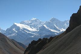
Vous allez où après le lac Tilicho ? Vous comptez revenir sur vos pas ? Parce que la boucle que j'ai fait, ça se fait très bien... j'ai croisé pas mal de monde en sens inverse à la montée du thorong mais une fois au col, j'ai gouté à une chose rare: des vues magnifiques sur les annapurnas en descendant le thorong (dans le sens où tout le monde le monte) avec pas l'ombre d'un randonneur (si ce n'est la mienne).
Si vous tenez à faire la montée Jomsom - Mesokanto - Tilicho, je peux checker si j'ai pris un ou deux points GPS... va falloir que je fouille dans mes archives.... je reviens plus tard.
Bon, comme je suis un mec qui range tout super bien (hummm), retrouver quelques points GPS ne m'aura pris que quelques min.
J'ai 2 points juste au dessus de Thinigaon. Cela devrait vous permettre de sortir de la ville & la vallée, ce qui est souvent le plus dur.
Voici:
- 28° 46.145'N, 83° 43.670'E
- et juste au dessus: 28° 46.051'N, 83° 43.773'E
Si tu positionnes ces points sur google earth tu verras qu'il sont associés à une grosse piste: c'est effectivement le chemin qu'il faut prendre. La grosse piste ne dure pas longtemps, elle se transforme assez vite en piste moins "autoroute" puis en petit chemin monotrace plus loin.
Curieusement, lorsque je suis descendu du Mesokanto la jusqu'à Jomsom, je ne suis pas passé par Kaisang, mais un peu au dessus.
J'ai croisé plusieurs fois des panneaux indicateurs "Lac tilicho" au cours de la descente, mais ils sont très espacés. Je pense qu'une fois engagé sur le chemin sur la base des 2 points GPS que j'ai indiqué, il vous faudra y aller un peu au pifomètre mais vous devriez vous en sortir sans problème.
Voici le point GPS du Mesokanto la: 28° 43.089'N, 83° 49.456'E
Comme tu pourras le voir sur google earth, c'est assez raide, mais le chemin descend en zig zag. En soi, le fait que ce soit raide n'est pas problématique mais retour d'expérience de novembre 2012: cela peut etre glacé ! Et la glace recouverte de poussière dans des pentes raides... quel bonheur à descendre 🤪 (à monter dans votre cas).
En prévision de conditions un peu pourries, des batons de marche constituent le strict minimum. Si vous voulez sécuriser, crampons et piolets (franchement à la descente, j'aurais pas craché sur un piolet) !
Une fois passé le Mesokanto la, les paysages sont extra et immédiatement après le col, la trace est évidente... pour un temps du moins. Attendez vous à des passages sans traces. En venant du sens inverse, j'avais combiné mon pifomètre gradué, la découverte de quelques cairns et la recherche de quelques panneaux de ce genre pour m'orienter:
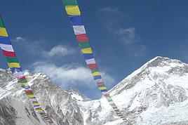
http://2.bp.blogspot.com/...c/s1600/IMG_6831.jpg
Mefiez vous des cartes qui indiquent la possibilité de passer le long du lac versant est: ca ne passe pas ! Versant ouest, il faudrait s'encorder (passage sur glacier) et ça craint et encore une fois le long du lac versant est, ça ne passe pas => passez par l'eastern pass indiqué sur les cartes.
Une fois à l'eastern pass, ça sera du gateau en termes d'orientation jusqu'au lac Tilicho.
Si tu veux je peux te mettre à disposition plusieurs photos pour te donner une idée de l'itinéraire/vous donner quelques repères complémentaires.
Un tout autre sujet: j'essaie de reprendre les "soirées trek" avec mes camarades.
Mais nous sommes toujours confronté à quelques problèmes logistiques et organisationnels avec le resto qui nous accueille jusqu'ici. On espère que ça va se débloquer prochainement.
Merci Samuel pour toutes ces précieuses précisions. Je regarderai de près tes indications. Nous comptons monter et descendre par le même chemin car notre temps est réduit. J'espère aussi que nous nous revoyons bientôt.
Bonjour Samuel,
Je viens de positionner tes 2 points au départ qui me confirment l'itinéraire à son début. Je vois aussi qu'en novembre 2012, la Mesokanto la était autorisée (j'avais lu qu'il ya un camp militaire dans lequel on peut facilement se fourrer et avoir des problèmes...). Je pense qu'aller jusque vers Kaisang ne sera pas compliqué. Si tu as quelques repères aprés Kaisang cela pourrait nous être très utile...
Merci de ton aide en tous cas.
Bonjour et merci pour ces photos qui montrent bien le chemin. Ca semble fort enneigé... J'ai repéré quelques points GPS pour la montée avec l'aide de Samuel . Dis moi si ça t'intéresse.
Salut,
Voilà mes relevés sur GE. Rien n'est sûr sauf les pts "avéré" donnés par Samuel et Mesokanto la (important car on trouve vraiment n'importe quoi par ailleurs. Le reste dépendant de ses descriptions. Toutes les cartes vues sont fausses comme d'habitude. Samuel ne passe pas par Kaisang (pt avéré Wikimapa): 28°44'12.51"N 83°46'58.58"E 3829. Nous comptons donc ne pas y passer non plus.On verra bien.
selon SA avéré environ Thinigaon 28°46'8.70"N 83°43'40.20"E 2931
selon SA avéré 28°46'3.06"N 83°43'46.38"E 2992
selon SA 28°45'56.12"N 83°44'26.95"E 3228
selon SA 28°45'40.55"N 83°45'54.35"E 3558
selon SA 28°45'38.27"N 83°47'0.12"E 3932
selon SA 28°45'26.28"N 83°47'43.98"E 3991
selon SA avéré 28°45'10.02"N 83°48'20.52"E 4077
selon SA 28°44'57.73"N 83°48'12.67"E 4144
selon SA pt eau abri 28°44'29.26"N 83°48'28.47"E 4191
selon SA 28°44'14.61"N 83°48'9.77"E 4234
selon SA 28°43'54.58"N 83°48'46.14"E 4538
Mesokanto pass selon SA 28°43'5.34"N 83°49'27.36"E 5235
selon SA 28°43'4.59"N 83°49'32.64"E 5220
selon SA 28°43'2.56"N 83°49'49.75"E 5280
selon SA 28°43'4.40"N 83°49'59.70"E 5263
La descente vers le lac Tilicho me gêne car en fait le chemin semblerait remonter après le col ce qui est bizarre. Je compte y repasser un peu de temps avant de partir ainsi que sur la montée de la passe elle même avec les photos du lien que tu m'as transmis.
Les points actuels (peu sûrs donc) sont:
28°43'4.59"N 83°49'32.64"E 5220
28°43'2.56"N 83°49'49.75"E 5280
28°43'4.40"N 83°49'59.70"E 5263
28°42'34.03"N 83°50'19.85"E 4960
28°42'29.33"N 83°50'23.92"E 4925
Nous comptons faire le trajet du 14 au 17/10 à partir de Thinigaon où nous comptons refaire les vivres. Ce trajet sera effectué si nous sommes en forme au sortir du tour du Dhaulagiri car la montée est une réelle épreuve. Nous revenons par KTM et le parc du Makalu où nous avons des amis pour être en France le 31/10. A ce moment nous aurons l'itinéraire complet que je pourrai t'envoyer sauf que ce sera probablement trop tard? Je peux te transmettre mon relevé global avec l'agenda y inclus le Dhaulagiri sur excel si tu me transmets ton adresse email.
Un petit retour d’expérience suite à notre trek autour des Annapurnnas du 6 au 28 novembre... Tout d’abord, ce trek est magnifique, avec un coup de cœur pour…
Je souhaiterais faire le tour des annapurnas en solo de mi octobre à mi novembre. Après avoir lu pas mal de discussion je ne voudrais pas manquer la découverte…
Quelqu'un est-il intéressé pour faire ce trek au mois d'octobre/novembre de cette année 2019? histoire de faire un petit groupe 2 trois ou quatre personnes…
Je pars pour le tour du Dhaulaghiri en avril ; Je vous ferai un petit compte rendu en rentrant. En attendant, si certains le font actuellemnt, ou bientôt,…
Je devais partir avec un groupe d'amis pour faire le tour du Manaslu et la vallée de tsum le mois prochain, mais les aléas de vie ont décimé mon groupe si bien…
Hi,
We’re planning to do the 4-day trek from Mestia to Ushguli without an agency. The descriptions mention that there are accommodations at each stop, but we can’t find any details about them. Has anyone got info or feedback on this route?
We're planning to trek in Peru and Bolivia and would love to find some local agencies.
If you know any, could you share details on prices and, of course, the names of the agencies?
Which trek would you recommend?
Elocine
Je pars en autonomie totale sur un trek au Maroc (10jrs) Imilchil - Aghbalou.
Trouve t-on des cartouches gaz à vis (Coleman, Primus) à Marrakech (adresse) ou villages entre Imilchil - Aghbalou ?
Si non , trouve-t-on des cartouches Butagaz pour camping-gaz (petit volume 230 gr ...)
Merci d' avance pour vos réponses
Hello, I’d like to embark on a little trip in my home country, Switzerland. I’ll start walking from La Cure, heading toward Le Noirmont first, then I’ll improvise my route—but it’ll probably follow the French border... at least as far as Lac de Joux.
I’ll decide day by day how much farther to go after that. My goal is to stay in nature as much as possible, wander around for as long as I can, and restock food in villages or towns along the way.
I’m thinking of mostly camping, but we’ll see if I end up in a hotel or another campsite depending on my route.
I’d love to reach La Chaux-de-Fonds on foot... maybe even Delémont.
The whole thing should take about a week, give or take.
I’ll be bringing my dog, and I’m preparing for this as soon as I’m ready.
Any tips to make sure everything goes smoothly for us? Things I should know—or avoid? What about shepherds with their flocks of sheep? And isn’t hunting season open right now?
I’m not sure if what I’m planning is even doable, which is why I’m asking around.
This’ll be my first time doing something like this—wandering in nature *and* with a dog. I’m really excited for this adventure... and I need it. Thanks!
We’re really keen on ecosystems and want to hike in "natural" ancient forests—not planted woods or areas heavily degraded by human activity. Travel guides (like Lonely Planet) don’t provide much info on this. Could you point us to the most interesting spots?
Thanks in advance for your tips.
We wish you happy holidays and a fantastic 2026, full of discoveries!
Claire and Albert
Hi, this might not be the right section, but I’d like to know if it’s possible to start mountaineering with another person without necessarily hiring a guide. We’ve done quite a bit of hiking but not mountaineering—we’ll just do a half-day glacier course. After that, we were thinking of starting with La Grande Motte and the Pointe de la Traversière, which were recommended to us. Honestly, for things like roping up and knots, I’ll learn at home with lots of videos and a book.
Hi,
I don’t know Switzerland at all and was wondering if Vallée des Joux and especially Dent de Vaulion are packed early in the morning or late in the afternoon in July and September?
If so, do you have any quieter spots to recommend in the area, or in Luxembourg (yes, I know it’s not the same country 😉)?
Thanks a lot!
Jaimerais savoir si quelqu'un aurait fait des treks sur le Ruwenzori et combien ça coute en moyenne, les infrastructures, les paysages la sécurité sur les lieux, merci beaucoup. J'attends avec impatience vos réponses.
We’re leaving in 9 days for a two-week trip to Madeira, mainly to hike.
From my research, I’ve found that since last year, access to most trails—and systematically for the most popular ones—is now paid. You have to pay an access fee of 4.50 € per person per classified hike in 2026, and even 10.50 € for the most iconic hike: Pico Arieiro to Pico Ruivo. When paying, you also have to choose a day and a 30-minute time slot for your start time. Of course, this reservation is neither changeable nor refundable, even if the weather that day is terrible.
Personally, given the massive influx of tourists to the island in recent years, I don’t mind paying a fee to help maintain the trails. Similarly, setting a limit on the number of people who can hike them per day is certainly preferable to preserve this priceless heritage.
However, what’s much less fair is that in reality, most of the available spots are reserved: 1/ for Madeira residents (which is normal); 2/ for "economic operators" (meaning local tour operators). For example, if you’re a non-resident (independent tourist), no booking is possible for the Pico Arieiro hike for an early morning start before September! So, unfortunately, we’ll have to skip this hike.
It’s the same issue for Ponta de São Lourenço, the 25 Fontes, Pico Ruivo... in short, all the most popular hikes. Oh well, we’ll skip those too!
So my question is: which hikes do you recommend where we won’t face the huge crowds that the others get? And where we can book the day before for the next day, taking the weather into account?
Finally, a quick accommodation question: we’ve booked the first week in Funchal, but I haven’t decided yet for the second week. Do you have any advice on where to stay in the south or north, preferably avoiding overly concrete-heavy and touristy spots?
I’m reposting about the logistics for Samaria Gorge.
I’d love to get recent info, especially about whether it’s possible to park my car in Omalos, do the hike, and then catch a bus back to my vehicle.
In theory, it’s doable, but when you check the KTEL website, there aren’t any feasible schedules listed. If anyone has recently organized this with reliable, verified details, I’d really appreciate it. Thanks in advance!
Hi there,
We’re flying from Montreal to Lyon this August to go hiking in the French Alps. We’ve rented a car and will be staying at campgrounds. We’re planning to do day hikes and want to stay a few days in one spot, do a few hikes, then move on to our next camping spot. Could you share your favorite spots or any recommendations for places to spend a few days with great hikes?
A few details:
We arrive in early August and leave in early September.
We’re looking for day hikes (or shorter), moderate difficulty, with a cumulative elevation gain of no more than 1000m, and of course, beautiful scenery!
We’d prefer not to drive too much—maybe it’s best not to head too far south and deal with unnecessary heat?
Along the same lines, if you know of any great campgrounds where we can start our hike directly without needing the car, we’d love to hear your suggestions!
Bonjour
Souhaitant faire de la randonnée sur cette île, je voudrais d'abord savoir quelle serait la période la plus favorable sachant que j'avais passé quelques jours en novembre 2018 pas pour cette activité mais plus pour une simple découverte de l'île et le temps n'était pas top notamment en montagne. Donc peut on choisir une organisation en étoile sachant que je louerai un véhicule avec éventuellement 2 points d'hébergement.
Je n'envisage pas d'intégrer une structure mais de partir à 2 et de s'organiser sauf si vous me conseillez une agence locale ou un guide local. Enfin même si je compte me procurer les différents supports, carte et topo guide plus gps je vous remercie de bien vouloir me communiquer les randos à faire en priorité
Merci beaucoup pour vos informations
I’m planning to do the Mercantour crossing following the Randoxygène route in mid-July.
I’m used to hiking in the mountains, but I sometimes get vertigo, for example on ridges with drops on both sides. I wanted to check if there are any T4 or T3-T4 sections and find out if there are any very exposed passages—and if so, where—so I can plan an alternative route.
Can anyone give me some info on this?
Thanks!
I’m planning a trip around Cap Corse and the AGRIATES in 2026, from May 8th to 15th (there are still 2 spots left, by the way! Just DM me if you're interested).
I’d love to know which hikes are worth prioritizing in the AGRIATES. We’ll be staying in SALECCIA for two days as our base—what should we focus on from there?
A round trip to IGNHU beach? Any other suggestions?
For Ostricano, I think it’s too far for a round trip...
Thanks for your tips!
Have a great day,
Anie, Toulouse
I’d like to get some info about the GR10 Pyrenees traverse. I need help planning the daily stages and accommodations—my wife isn’t an experienced hiker but walks a lot, so I’d like to schedule shorter walking days and thus a longer overall trip in terms of number of days.
Could anyone give me some help and advice?
Best regards,
New to this forum, I’m planning a pretty big project for 2028.
I’m heading to Nepal to do a trek from Kathmandu all the way to Everest Base Camp (a cool 5,300 m 😄).
This trek is a bit special because even though I’ll be part of a group, I’m going solo (so far, no problem—I’m used to it). But it’s my first real trek, and it’s also a humanitarian one: once I reach base camp, I’ll stay an extra week to help clean up the waste left by tens of thousands of climbers! Since I’m originally from South America, from two countries that share the Andes, I have a deep respect for mountains—they fascinate me. So Everest… it’s kind of the trip of a lifetime!
So, a little question for those who’ve done treks to Everest before… any tips for good mental preparation (I’m already working on the physical side)?
Hi there, I’m planning the Annapurna Circuit for March 2027 and I’m looking for a local agency with a local guide—preferably French-speaking—to arrange this trek for us. Any suggestions? Thanks
Hello!
We’re spending a few days in Toraja country at the end of May. We’d love to do a day trek—taking our time—on a route that’s stunning in terms of scenery, but not a level 5 in difficulty!
Any suggestions you can share, please?
Thanks in advance
I’d like to do the Mare a Mare Sud in May over 4 days. I’ve found quite a few places to stay along the route, but I’m stuck on the start and finish.
I’ll be arriving by plane on Sunday evening and would like to start pretty early on Monday morning. Ideally, accommodation right at the trailhead (Alzu di Gallina) would be amazing, but I can’t find anything. Any tips?
Also, for the transfer from Figari Airport to Porto Vecchio or Alzu di Gallina?
At the end, I’d like to pick up a rental car—any advice on that too?
I’m traveling solo by plane to Catania in May and plan to hike the northern side of Etna, starting from Linguaglossa where I’ll arrive by bus. After that, I’d love some info on how to get up to Piano Provenzana (shuttles or hitchhiking), since it seems there’s no public transport except in the summer. Can you sleep there in a free or cheap refuge, or camp? And how far up can you go without having to hire a guide? Thanks in advance. Bernard.
Bonjour a tous,
je pars en voyage au Maroc en aout et nous allons commencer par nous arrêter a Chefchaouen(nous sommes en voiture).
Ma question: quelqu'un peut il m'indiquer un itinéraire de rando en boucle d'entre 5 et 7 jours aux départ de Chefchaouen dans le parc de Talassemtane passant si possible par le pont de dieux?Ou un guide papier qui en reunis quelques uns?
Nous privilégions le camping sauvage et les gites.
Merci d'avance
Hi there, for those who’ve been recently—is it possible to find other solo travelers in March on the island to share transport or room costs? It doesn’t seem easy to travel on a budget.
If you have any recommendations for simple lodgings or places with dorms, I’d love to hear them.
For those who’ve done multi-day treks while moving around: do you need to bring your own sleeping bag? I’d love to hear about itineraries you’ve done without a guide, just with a map and GPS.
Thanks, and have a great day!
Hi everyone!
We’re planning a 15-day road trip to Scotland this summer, specifically to explore and hike on Lewis and Harris—places we’ve never been before. We’ve visited other islands on previous road trips in Scotland (we usually go in April for a week). This would be our first time in Scotland in the summer and for 15 days. We’re looking at late August to early September.
I’m currently drafting the itinerary. We’d be crossing from Ullapool and were thinking of spending 3 nights on Harris and 4 nights on Lewis.
Does that sound balanced to you? Is it better to keep the same accommodation on Harris and the same on Lewis to explore the area? I’d love to hear about any past experiences you’ve had on these islands.
Thanks!
Hi there, I’m trying to leave for 15 days very soon to São Vicente. I’m either looking to join an agency or figure things out on my own to go hiking on one of these islands or both. From what I’ve seen, it’s not easy to organize with local transport, so it gets expensive. Can I use the services of a small local agency? I’m looking for the simplest way to hike for several days. Also, how do you get from São Vicente to São Nicolau? Thanks in advance and have a great day!
Aichatou
I’ve been wanting to do this for several years, and this year’s the one. Next September, I’ll be trekking in Tusheti (Georgia), from Omalo to Shatili.
Of course, I won’t be renting a vehicle that’d just sit unused. No problem getting to Pshaveli, but from there to Omalo, it’s a dirt road (still the case?)
There must be some form of public transport since there are so many guesthouses, and not all travelers come in a 4x4.
If any of you have been to Omalo, could you confirm that these shared transports exist and how often they run?
we’re planning a trip to Yellowstone and hoping to do a three-day backcountry hike if we get a permit.
if any of you have done this before, could you let me know if it’s possible to find water along the way? And if we can transport it, are we allowed to use a stove?
Hello,
I’ll be in Nepal from March 6th to 29th (we’re flying into Kathmandu via Varanasi and leaving via Delhi).
I’m a bit confused about the regulations requiring a guide.
My wife and I (we’re 63 and 64) aren’t experienced trekkers—we’re more used to walking on terrain with very moderate elevation changes. I’m looking for fairly easy hikes, possibly day trips.
Here are my questions:
- Does the Poon Hill trek from Pokhara require a guide, or is it better to go through a local agency? (I’ve seen a lot of them offering 4-day packages)
- I’d like to do a few multi-day hikes around Jomsom (Kagbeni, Mukitinath, Lupra, Marpha)... Do you need a guide for those, and can you find accommodations easily without booking in advance?
Last question—I’m really hesitant to lug around a sleeping bag or down jacket during our 6 weeks in India. Can you easily find these kinds of items at reasonable prices in Pokhara?
Thanks in advance for any tips you can share!
Yann