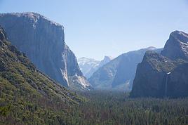
Nous préparons un itinéraire à vélo à travers les USA. Nous visiterons entre autres, les parcs nationaux au Utah, du sud vers le nord, donc on passera à Bryce Canyon et nous prendrons la route 12 pour rejoindre Escalante puis Boulder. De là, nous sommes tentés de prendre Burr Trail jusqu'à Bull Frog avant de remonter au nord par la 276 et la 95 jusqu'à Hankville.
La question: est-ce un trajet plus intéressant que la route 12 jusqu'à Torrey puis prende la 24 vers Fruita, passer à travers le parc de Capitol Reef en direction de Caineville?
De Bull Frog, pouvons-nous prendre une autre piste plutôt que la 276 et 95 pour remonter vers Hankville?
Est-il permis de camper librement dans ces secteurs?
Côté ravitaillement (eau, nourriture) quelles sont les possibilités?
Nous voulons rejoindre ensuite Moab pour avoir accès à Arches et Canyonlands. On ne voit aucune façon d'éviter de monter au nord sur la 50 avant de redescendre la route 191 vers Moab: connaissez-vous un "raccourci" par une piste qui peut se faire à vélo?
J'attends vos suggestions, cyclistes qui avez déjà fait ces routes mythiques! 😉
J'ai fait un boucle a velo dans le sud-ouest de Utah en visitant Zion, Bryce, Cedar Breaks, et Snow Canyon. C'etait excellent. Je l'ai fait en mi-mai quand le temps n'est pas encore trop chaud. Arches, Canyonlands, et Capitol Reef je connais seulement en voiture. Je deconseille Capitol Reef a velo. Tres peu de routes sont goudronnees, et l'etat des autres routes n'est pas toujours bon, et ne sont pas practicable s'il pleuvait recemment. Meme en voiture, il faut amener suffisamment d'eau pour plusieurs jours puisqu'on peut etre coince pour quelques jours apres la pluie. Aucune possibilite pour le revitaillement sauf a Torrey, je crois, et de l'eau a Fruita. Burr Trail a velo??
nous pensons partir faire un tour en commençant peut être par l'utah en venant soit de Los Angeles soit de San Fransisco...
A quoi doit on s'attendre si on par en mai dans cette région des canyons?
Le temps est bon en mai, mais il y a une grande variation de temperature selon l'altitude. J'ai visite Bryce Canyon NP et Zion NP a velo en mi-mai. Temps parfait a Zion, un peu frais a Bryce Canyon. J'ai visite Canyonlands NP en mai (en voiture) et il y faisait tres chaud. Ta route a beaucoup de denivelation. Moi, je ne commencerais pas a SF ou LA pour visiter les canyons de Utah et Arizona.
J'ai fait un voyage au USA ce printemps (pas en vélo mais quand on est cyclo on a toujours un regard cyclo) et pour t'éclairer,
je peux t'envoyer 2 ou 3 photos de la piste si tu fait de Torrey à Bryce par Norton road et burr trail, j'ai essayé d'en joindre à cette réponse mais ça coince . Il faut un VTT ou routier sérieux avec pneus assez larges et réserve d'eau, tranquillité assuré.
Bonne préparation, regardes bien sur le forum il y a beaucoup de choses, voir des gens comme Vnoa, Vasyvite, Utat , Bastinj, le Tigre, Aquilegia parmi les principaux leurs conseils sont excellents.
voici un extrait que j'avais copié en préparant mon circuit :
@ Aquilegia
notre parcours entier est de rejoindre Yellowstone puis les Rocheuses pour finir à Vancouver (ensuite l'Amérique du sud).
Le sens de ce parcours je le pense pour l'instant comme ça parce qu'il est difficile de gerer ce parcours en fonction de la météo.
Les Rocheuses entre juin et aout, et l'été les canyons sont réputés tres difficile à cause de la chaleur trop forte.
Alors je me disais que mai ça pourrait peut être le faire. Merci de tes conseils.
Pourquoi, ne pas partir de SF ou de LA? on préférerais SF parce qu'on aurait aimé visiter... mais on est à l'écoute de vos conseils..
@Miju69
Merci pour ces liens qui me serviront aussi.
Pour nous on passera un peu plus à l'est et sinon pour faire Brice > Torrey il y a la 22 et la 12... goudronnées
Si tu veux de infos va voir chez adventure cycling! Tu trouveras tout ce que tu veux! Cartes infos sur leur forum. J'ai fait un voyage en vélo en 2010 Vancouver- San diego.
Concernant ton idée la route 12 depuis Torrey jusqu'à Boulder est superbe!
ça monte raide mais quel spectacle!
Question dormir tu peux camper au "bord de route" quand tu peux à l'abris des regards!
Pour le ravitaillement pas de soucis pour l'eau pour la nourriture basique aussi!
Pour rejoindre Moab depuis Torrey c'est possible par hankville mais bien s'organiser car il n'y pas pas de ravitaillement pour remonter vers green river.
Canyonalnds en vélo c'est faisable mais prevoir de la nourriture
Dites moi votre point d'arrivée et votre point de départ?
Jacques
j'ai trouvé plusieurs post ou tu dis : (il ne faut absolutment pas aller du South Rim a Las Vegas a velo. Horrible en voiture, un desastre a velo.)
mais si je zoom sur Google je n'y vois qu'une autoroute, la 40...
Passer par le nord... pas mieux puisque de Vegas à St Georges il ne semble n'y avoir que la freeway 15...
A ce sujet la meilleure vu sur le Grand Canyon semble etre au sud vu que la zone la plus touristique s'y trouve. La vue côté nord en passant par la 67 (Keikab) est elle vraiment moins bonne?
A ce sujet beaucoup d'endroit ne sont ralliés que par autoroute... Sic!!😕
En tous cas Aquilegia, merci pour tes précisions sur les différents posts sur le sujet. Tu semble être un guide hors pair sur la région...😉
Pourquoi, ne pas partir de SF ou de LA? on préférerais SF parce qu'on aurait aimé visiter... mais on est à l'écoute de vos conseils..
Les paysages de la Californie sont soit spectaculaires soit monotones. La route directe entre SF et Yosemite NP est tres monotone. Entre LA et Death Valley, c'est peut-etre pire.
Voici quelques possibilites: Si Tioga Pass dans Yosemite NP est ouvert (la date est tres variable selon le niveau de neige qui tombe en hiver), tu peux aller de SF a Yosemite, et puis vers Las Vegas a l'est du massif Sierra Nevada. Il faudrait traverser la vallee centrale de Californie qui est tout plat et sans interet. En ete, il fait tres chaud dans cette vallee.
Ou bien, tu peux suivre la cote de SF jusqu'a San Luis Obispo/Paso Robles. C'est une tres belle route. Mais de SLO/Paso Robles vers l'est, il faudrait traverser une grande region sans interet.
Si tu veux absolument visiter Death Valley, il faut savoir que tu auras beacoup de denivellation et pas mal de paysages sans interet hors du parc.
j'ai trouvé plusieurs post ou tu dis : (il ne faut absolutment pas aller du South Rim a Las Vegas a velo. Horrible en voiture, un desastre a velo.)
mais si je zoom sur Google je n'y vois qu'une autoroute, la 40...
Passer par le nord... pas mieux puisque de Vegas à St Georges il ne semble n'y avoir que la freeway 15...
A ce sujet la meilleure vu sur le Grand Canyon semble etre au sud vu que la zone la plus touristique s'y trouve. La vue côté nord en passant par la 67 (Keikab) est elle vraiment moins bonne?
A ce sujet beaucoup d'endroit ne sont ralliés que par autoroute... Sic!!😕
En tous cas Aquilegia, merci pour tes précisions sur les différents posts sur le sujet. Tu semble être un guide hors pair sur la région...😉
Dans l'ouest des USA, les cyclistes ont souvent le droit de pedaler sur l'accotement des autoroutes si aucune alternative existe. Je l'ai fait moi-meme, mais je prefere l'eviter.
A mon avis, les vues du South Rim du Grand Canyon sont plus variees. Les routes a l'est du Grand Canyon Village seraient assez agreables a velo. Pareil pour la route entre Flagstaff et Grand Canyon Village. Et la route entre St. George et le North Rim ne serait pas mal a velo. C'est assez haute, donc frais en mai. Pas mal de foret de pin. Mais c'est different entre le South Rim et Las Vegas. C'est une route monotone avec beaucoup de denivellation. Je crois que tu peux eviter pas mal de l'autoroute 40 en empruntant l'ancienne route 66.
Lors de mon tour a velo dans le sud-ouest de Utah, nous avons pris une navette directement de l'aeroport de Las Vegas a St. George. On a pris nos velos mais nous avons reserve ca. Si tu veux absolument tout faire a velo, j'avais l'impression que l'accotement de l'autoroute 15 serait supportable.
Alors peut être faire San Franscico > LA par la route 1
puis prendre le train (si c'est possible avec les vélos) jusqu'à Flagstaff et remonter sur South Rim puis Page pour voir Antelope Canyon ensuite Zion et Bryce et poursuivre sur le nord vers Salt lake? On ratera Monument valley et Arches mais on ne peut tout voir...
Qu'en penses tu c'est faisable en partant en mai?
C'est une bonne solution, a mon avis. SF->LA sur la cote est tres jolie. Le temps est normalement tres agreable en mai en Californie. LA->Flagstaff en train, parfait. Et puis les paysages varies en Arizona et Utah avant la chaleur de l'ete.
Suivant tes conseils j'ai modifié l'idée de mon Parcours.
Celui ci te parait il plus adapté? sais tu si e train de LA à Flagstaff avec le vélo est il faisable?
Oui, c'est plus adapté. Selon le site d'Amtrak, on peut amener un velo entre LA et Flagstaff. Il faut mettre le velo dans un carton, ou bien, on peut acheter un carton a la gare pour $15. Le train arrive a Flagstaff en pleine nuit. Si tu as des problemes avec Amtrak, tu peux aller a Las Vegas en bus, et puis a St. George soit a velo soit eventuellement avec le St. George Shuttle. Mais dans ce cas, ca sera le North Rim du Grand Canyon que tu verras.
Selon ta carte, tu seras jusqu'a l'est de Glacier NP (Montana). Il te faut absolument visiter le parc et faire Going-to-the-Sun Road (Logan Pass). La route et le parc sont magnifique!
Merci encore pour ses infos....
RRRrrrr ces trains où il faut tout emballer les vélos... c'est pas mieux qu'en France.
Mettre les vélos dans un carton c'est encore démonter les vélos puis avoir à les remonter.
En fait pour Las Vegas, on hesite franchement parce qu'on est pas fan des grandes villes. SF et LA c'est juste pour faire la N1 le long de l'océan.
Passer par le nord casse un peu la boucle qui passait par Page et Zion avant Brice mais comme on est pas encore parti, on peut encore changer.
ça doit être une erreur.. voici un trajet plus simple...
et le lien pour les transports vélo, on doit avoir certains trains équipés pour les prendre entiers sans carton
Les bicyclettes de grande taille peuvent être transportées à bord sur certains trains ayant le service de bicyclette à bord. Les bicyclettes doivent être rangées dans un endroit désigné à l'intérieur du wagon. Les réservations peuvent se faire en ligne ou en composant le 1-800-USA-RAIL.
Les bicyclettes couchées, tandems et autres bicyclettes inhabituelles qui excèdent les dimensions standard des bicyclettes, et qui ne peuvent être logés dans une boîte standard pour bicyclette sont interdits.
Si ça peut intéresser quelqu'un, voici deux liens pour visionner deux petites vidéos (téléphone portable) de mon voyage en vélo en Utah, du sud au nord en…
Entre autres projets, j'ai envie de faire une grande boucle autour de Las Vegas en visitant Death Valley, le désert Mojave et filer vers le Grand Canyon. Je…
Je prépare un voyage à vélo qui aura lieu à l'été 2007. Pensez vous qu'il est raisonnable de traverser L'Utah et le Nevada à Vélo? J'ai déjà une bonne…
Avis à toutes celles et ceux qui arpenteront la zone Red Canyon / Bryce Canyon / Kodachrome Basin / Escalante / Capitel Reef, mardi 5 août 2014: Le Tour de…
I’m planning to cycle from Morlaix to Brest (via Roscoff and the V45 coastal route). We’ll start riding on August 16th for 13 days (with stops for island visits, surfing, etc.). Is there a lot of traffic at this time of year? I’ve got two kids, 11 and 13, and we don’t like riding in the middle of cars (we’ve already done the Vélomaritime—Caen to Cherbourg—the Loire route from Orléans to Saumur, the Vélodyssée from Nantes to Royans, and the canals like the Nivernais and Bourgogne, where there were plenty of bike-only lanes, which isn’t the case on this route).
Thanks for your help if you’ve already done this route in late August!
Virginie
I’ve got my flight ticket sorted—departing in mid-November and returning in mid-March. I’ll arrive in Santiago and leave from Buenos Aires.
I’ve already been to southern Argentina, specifically Torres del Paine National Park, and I’d love to go back to do the full W trek (I only did the shorter version last time).
I also want to do some hiking and maybe even tackle a summit. I climb and occasionally do some mountaineering, so I’ll definitely be going with a guide.
I plan to start around Temuco in Chile, with the idea of heading toward the lakes, then taking the Carretera Austral.
I’m not sure if I’ll go all the way to Ushuaia—it’s supposed to not be *that* worth it, except for the bragging rights of saying you’ve been to the end of the world.
I saw there are lakes in Argentina too.
I don’t have a precise itinerary, but what I’d love is, once I reach the southernmost point of my trip, to take a mini-cruise to see some wildlife. Any tips for that?
What kind of sleeping bag did you take? Is a 0°C (32°F) one enough?
And one last question: white gas stove or can I get by with my gas stove?
This summer, we’re planning to cycle along the EV 19 that follows the Meuse River from Langres all the way to Rotterdam.
My question is about getting back to Nantes.
Do any of you know what the best return option might be? I’d love to hear about your experiences.
I saw that FlixBus doesn’t take bikes.
By train, I think it’s possible but would involve multiple local trains.
We were also wondering if there’s a boat from Rotterdam to Saint-Nazaire that could take passengers with bikes.
Any tips or experiences you can share would be really helpful—thanks in advance!
Have a great evening
Hi there,
I’ve been road cycling for several years, and I’m about to switch to gravel in the next few days—I’m waiting for my bike, which should arrive this week.
I’m planning a bikepacking trip in a few weeks along the Véloroute V81, also known as the Vélosud, from Biarritz to Le Barcarès.
Has anyone here already done this route? Any info is welcome, whether it’s about the route itself, gear, or accommodation. I’ll prioritize staying with locals as much as possible. On that note, I just signed up for the brand-new site *Guidon et Couette* ((www.guidon-et-couette.fr)), which offers free accommodation between cyclists across the country, but there’s almost no one listed along my route!
Thanks in advance.
Laurent.
I’m planning to build a new touring bike.
I want to prioritize lightness.
That said, I’m tempted by a suspension fork that could offer some comfort on rougher roads.
The recent appearance of gravel suspension forks on the market might meet my needs—at least on paper.
I’m particularly considering the RockShox Rudy Ultimate XPLR fork.
Unlike MTB forks, its travel is short: either 30 mm or 40 mm.
It weighs 1400 g, which is 400/500 g more than a steel fork.
Any thoughts or real-world feedback on this?
I’m also wondering about the durability of magnesium (lower leg) for long-distance bike touring.
And what’s the impact of skipping the manufacturer-recommended maintenance every 50 and 200 hours? That’s bound to happen on a long trip unless you carry extra gear.
More generally, how reliable are these kinds of forks?
Hi everyone,
I wanted to share with you the incredible feat my friend José, who’s 72 years old, is currently undertaking. He left Auterive near Toulouse on Monday, May 18, 2026, on his non-electric bike, heading for the North Cape in Norway!
You can follow his route on the link below—he’s currently in Sweden:
https://thierry-thomas.travelmap.net/jose-de-toulouse-a-nord-cap-2026
You can zoom in on the map and click on each stopover town to see the photos
I’m making an exception and creating a separate post this time, since it’s all about France. In May, we spent a week in Provence, specifically in the Luberon, exploring the cycling routes *Autour du Luberon à Vélo*, the *Véloroute du Calavon* (part of EuroVelo 8), and the shorter *Les Ocres à Vélo* route. Together, they gave us an amazing journey through rolling hills, vineyards, lavender fields still green in spring, and some of the most stunning landscapes in southern France.
It was, of course, the perched villages that impressed us the most. We visited Gordes, Roussillon, Bonnieux, Lacoste, Lourmarin, Ménerbes, Oppède-le-Vieux, Cucuron, and Lauris. Many of them are among the most beautiful villages in Provence, and it’s hard not to agree with that reputation.
One interesting point is the route of EuroVelo 8 in this part of the region. The official path mainly follows the old railway line of the *Véloroute du Calavon*, which is very comfortable and safe. But in our opinion, cyclists traveling EuroVelo 8 around the Mediterranean would discover even more treasures if the route passed through villages like Bonnieux, Lacoste, or Oppède-le-Vieux.
We were also pleasantly surprised by how safe cycling felt. Most of the route takes small local roads, but traffic is light, drivers are respectful, and road design really takes cyclists into account. It’s one of those places where you can ride peacefully even without separated bike lanes.
Our full story:
Around Luberon by bicycle - the most beautiful villages of Provence
You can also find all our cycling travel stories on the forum:
Cycling Thread - Europe’s most beautiful bike routes
Hi there, we’re a group of 4 cyclists looking to get from Treviso in Italy to Munich with our 4 non-folding bikes. It seems complicated! Are there any solutions? Thanks so much.
hello fellow cycling enthusiasts
here’s a travel journal of the cycling tour through the Rhône-Alpes Auvergne region by Claudio
zouli
it was the plan
http://cbandiera.free.fr/parcours/auvergne-Ralpes/
the trip was completed
story being posted online soon
1100 km in 11 days
beautiful and varied regions
Hi there, we’re planning a Munich to Venice bike trip at the end of June 2026. Getting back from Venice to Toulouse by train with 4 bikes isn’t straightforward. What return options have others who’ve done this trip chosen? Any tips or great deals would be much appreciated. Thanks a bunch! !
Hi everyone,
Happy owner of a Pegasus Estremo bike with a Rohloff hub, which is giving me trouble with the SF11-NCX-FT-E-LITE 700C TS 300/0 fork (serial number TD01329060). It’s starting to show its age, and I’d like to repair it to extend the life of my beloved bike.
The suspension is gone, and there’s an oil leak from the seals.
Does anyone know how to repair it? Where can I find parts that are about fifteen years old? Or where to find an identical replacement fork? Just to clarify, the Magura HS11 brakes are mounted using Firm Tech, meaning they’re on pivots behind the fork, facing the frame.
Hi, I'd like to know if anyone has done this route recently or has reliable info.
Does the track exist, and most importantly, is there sand (for biking)?
Any info is welcome.
Cheers,
diego ambilobe: mangaoka, manondro, ramena
vohemar sambava: masondrono, tanambao
Hi there,
New to bike touring,
I’d love to start with a section of the Via Rhona to explore and share (route to be decided).
Looking forward to exchanging tips!
I’m landing in Madagascar with a buddy before the end of April 2026. We’re planning to bike around for about twenty days or so. We don’t have a specific goal other than exploring the country and meeting the locals.
Ideally, we’d prefer a loop route starting from Antananarivo with a good chunk of it along the coast. On the bike side, we’re used to riding 6 to 8 hours a day, depending on the needs, encounters, and mood 😉 Any feedback or tips from trips around this length?
A big thank you to Lazarou for all the info you share in this forum!
I'm passionate about Morocco, which I cycled through back in 2009.
Last year, my wife and I explored the High Atlas by tandem. Completely smitten, we're heading back in April (Anti Atlas) and May (High and Middle Atlas), still on our tandem.
Do you have any info on the track between Amezri and Ali Ait Nito? Are the river crossings in the Tessaout still there? It's not easy to navigate with a loaded tandem... especially if the river level is high due to this year's heavy snowmelt!
Thanks in advance for any tips you might have, and best wishes for health in this new year!
Claudio specializes in the route of the Savoie lakes
Here are his travels
Between Bornes, Chartreuse, the Savoie foothills, and Dauphiné
Five lakes: Léman, Annecy, Paladru, Aiguebelette, Bourget, not to mention a few ponds along the way
Plenty of accommodation options: camping, hotels, and more...
A lovely route not far from his place
Rural and quite peaceful
A road cycling route created by Serge B...
Tout d'abord... bonne année ! De belles routes à vous en 2017 !
Je voyage depuis quelques années avec un VTT de très bonne qualité mais équipé de freins à disques hydrauliques. Je vis (pédale) avec l'inquiétude d'avoir une panne (fuite, bulle d'air, chaleur qui fait que le liquide...). Mon vélociste me dit qu'il est impossible de les changer pour des V brakes.
Qu'en pensez-vous ? Est-ce que je prends un gros risque à continuer (seule) avec ces freins ? D'avance je vous remercie pour vos bonnes idées.
First post here to share a quick recap of our west-to-east bike trip along Algeria’s coast in January 2025.
It was just the two of us—my partner and I—with French passports and not a word of Arabic. No friends or welcoming hosts in the country.
Under those conditions, we’d strongly advise against going.
Our original plan was to follow the coast from Algiers to Tunis. We ended up cycling from Algiers to Béjaia, then took the train from Béjaia to Annaba (with a stop in Constantine), and finally biked to the border.
We were tailed by police the whole way—whether on our bikes, on the train, or even on foot while exploring towns. On top of that, we couldn’t wild camp and were limited to the few state-approved hotels that accept foreigners. Under those circumstances, connecting with locals was especially tough.
With such an omnipresent and intrusive police presence, we’d definitely recommend against this destination for bike touring. A really sad situation that completely cuts you off from the local population...
We’d been warned, we went to check it out, and we weren’t disappointed!
Hi there,
I’m planning the route to cycle from Lille to Nordkapp with my partner.
Duration: 3 months, from May 1st to July 31st, 2026.
In the attached details below, I need to add some "non-riding" days (rest days, basically).
So I’m looking to "shorten" the trip by taking ferries or trains for some stretches. Which areas could I skip?
Thanks in advance for your great tips.
Have a good evening.
https://www.komoot.com/fr-fr/collection/4023980/-lille-cap-nord-1er-mai-au-31-juillet-2026?ref=collection
I’m planning to bike back from Poland this summer. Does anyone know a way to ship it there without having to take it apart? Otherwise, it’s a real hassle to fine-tune all the settings before departure!
Thanks in advance.
Hi, has anyone recently bought Primus or Butagaz gas, possibly puncture-style, in Dubrovnik or the surrounding area? Same question for Albania... thanks. aichatou
Just a few words about the loop I did by bike in Yunnan.
Entry and exit
I entered China through the Sino-Vietnamese border crossing at Lào Cai / Hekou under the 30-day visa exemption currently available to French nationals and others.
The process was simple and quick. A Chinese police officer even helped me complete my electronic pre-registration at a computer kiosk. I wasn’t aware this formality was required—it’s similar to Thailand’s TM6.
No issues with the bike.
I left the country via the Sino-Laotian border crossing at Mohan / Boten.
The atmosphere was a bit chaotic there, but again, no problems with the bike.
The timing
I visited Yunnan in February 2026.
Weather-wise, at higher altitudes (between 1,500 and 2,000 meters), it was around ten degrees at night and in the mornings, and around twenty degrees at the hottest part of the day.
I had two days of rain, so I took the bus to keep moving. Otherwise, clear blue skies.
Culturally, Chinese New Year fell on February 17th (and the 15 days following), right in the middle of my trip. Because of this, my take on the traffic might be off.
Accommodation and food
I always found a hotel to stay in for prices ranging from 8 to 15 €. Except in Kunming (the capital), where many hotels were fully booked (Chinese New Year). I ended up at a 100 € hotel with great value for money.
A bowl of noodles costs about 1.5 € on average.
Onboard electronics
Since my smartphone doesn’t support eSIMs, I subscribed to a China plan with my carrier. Otherwise, for much cheaper, Alipay offers eSIMs for foreigners that allow access to services usually blocked for Chinese users (WhatsApp, Facebook, etc.).
An internet connection is essential for paying with Alipay or WeChat, as this payment method is widespread.
I only managed to use Alipay.
Either way, always carry cash because sometimes there’s no signal, or the merchant only accepts WeChat.
Also, it’s best to bring a power adapter when you arrive rather than struggling to find one.
Traffic and roads
The Chinese aren’t reckless drivers. They follow traffic rules and watch out for cyclists. This is slightly less true in Xishuangbanna (the region bordering Myanmar and Laos).
In urban areas, there are almost always wide bike lanes, separated from other roads, where bikes, electric mini-scooters, and scooters share the space pretty harmoniously.
The roads are in great condition, and traffic is generally manageable—even light—except for one stretch (Eshan -> Yangwu).
Most traffic is absorbed by expressways, China’s equivalent of highways: toll roads that are off-limits to slow vehicles.
You’re never far from these expressways; sometimes you even ride alongside them, which can be noisy at times.
The climbs are usually reasonable, around 5% to 6%. From what I remember, the steepest section was between Menglun and Mengla, with gradients of 8% to 10%, sometimes more.
Riding at these altitudes—though modest—took a bit of getting used to.
The route
I didn’t plan anything in advance. My only goal was to reach Kunming. I don’t know why, but just hearing the name of that city, like Yunnan, always felt dreamy to me.
Hi! I’m planning to visit the Stockholm Archipelago by bike in early April.
Do you know if the boats will be running between the different islands at that time of year? For those who’ve already been, all your tips and recommendations are welcome—accommodation, etc. Also, do you know where I can rent a bike in Stockholm? Thanks so much in advance for your help!
Hello there, pedal-powered Young Boys!
Claudio (still from Faverges)
dreaming about a cycling getaway in Italy from Faverges (train all the way to Turin)
from Turin down to Venice along the Po River and back via the Padana (Alta Italia da attraversare – Northern Italy to cross)
The tricky part is getting from Chioggia to Venice.
I read it’s possible by hopping on a boat from island to island,
but it sounds a bit stressful.
Has anyone already tackled this route?
I’m currently looking for a bike to do my first bike trip across France, with the ultimate goal of cycling through Latin America. I’ve got a lot of questions and I’d love to hear if you have any answers or advice to share.
First off, I’ve been through this before with hiking. I want to get top-quality gear right away. When I started hiking, I ended up buying everything three times—first beginner gear, then intermediate, then expert, etc.
For biking, I’d prefer to skip that process and invest right now in a bike that could ideally handle Latin America.
I’ve set a total max budget of around 5000 € (roughly 4000–4500 € for the bike and the rest for accessories: panniers, helmet, cycling shorts, etc.).
So, I’ve got quite a few questions:
* I’ve read in several places that some people recommend buying the bike directly in Latin America. Since I need a first bike to train in Europe, would it be better to buy an entry-level bike in France (and sell it before the big departure)? Or is it preferable to start right away with my final bike to get used to it? Is buying it there just to save a bit of money?
* For a long-term trip (around six months) in Latin America, is it better to go for a gravel bike or a mountain bike?
* Should I buy a new bike or a refurbished one? Even more so given that I’m planning a long trip—could a refurbished bike end up causing more breakdowns?
If you have any advice on models, technical features to prioritize, or recommended sellers or resellers, I’d love to hear it. I’m a total beginner—I’ve only just started watching videos and reading up on the subject, and all the technical specs are new to me!
Calling all travelers.
We’ll be landing at Lyon Airport and want to bike to La Verpillière train station (with panniers and camping gear, etc.) to catch a TER to Voreppe.
What’s the safest route for this bike trip?
Thanks in advance
hi,
I'm planning a recumbent bike trip from the Pyrenees to Greece. On the EuroVelo 8 route, it doesn't specify the path through the Alps.
Are there any experienced cyclists here who can tell me where they go to avoid climbing too high?
Also, is there another traveler/bike forum better suited for broadening the responses?
thanks