Voilà, je voulais tester sur google map un itinéraire en 3 semaines qui me parait pas mal.
Malheureusement, après avoir intégré plusieurs "destinations" je n'arrive plus en ajouter d'autres (ex : LV - LA). De plus il me semble qu'entre LA et cambria, le temps de route est quand même important non (plus de 5h00). Y a-t-il moyen de l'éviter?
Voici l'iténéraire qui a été proposé sur ce site:
J1 : Vol pour Phoenix
J2 : Phoenix - Grand Canyon South Rim - nuit au Maswick Lodge par ex
J3 : Grand Canyon - Page - nuit à Page
J4 : Page - Monument Valley - nuit à Mexican Hat
J5 : Gooseneck, Valley of Gods - Moab
J6 : Moab J7 : Moab
J8 : Moab - Capitol Reef - Torrey
J9 : Torrey - Bryce Canyon
J10 : Bryce Canyon - Zion
J11 : Zion - Las Vegas
J12: Las Vegas
J13: Las Vegas - LA - visites LA
J14 : LA (Universal Studios)
J15 : LA - Cambria
J16 : Cambria - Monterey - SFO
J17 : SFO
J18 : SFO
J19 : SFO
Si je rajoute 2 jours (soit 21), où puis-je les mettre?
Il y a plein de postes qui traitent des limites d'étapes entre autre de Google Maps avec des réponses à ce probleme et d'autres ... il y a des alternatives citées !!!!
Postés encore très récemment
* 04.2016 - San Francisco (semi marathon) / New York / Washington
* 05.2015 - Chicago + Sud Ouest US -
* 08.2013 - Voyage en famille - Principaux Parcs West US.
* 06.1994 - http://georgesroy.perso.worldonline.fr/usa/
* 12.1986 - 1er Voyage USA (CA / AZ / Nevada / Colorado / FL)
Beaucoup plus fiable car prend en compte le trafic donc les durées de trajet sont beaucoup plus réaliste et tu peux y ajouter autant d’étapes que tu désires, tu n’es pas limitée. Je m’etonne que l’on continue d’utiliser Google Maps qui n’est pas très fiable.
Bonne préparation.
Non, ce n'est pas toi, c'est google qui est mal fichu sur ce point !
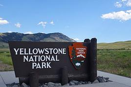
De même, si tu fais des simulations à la date d'aujourd'hui sur Yellowstone (un exemple), Google maps ne te tracera peut-être pas de route à causse de la neige. Et si tu changes la date, tu ne pourras entrer que 2 destinations 🤪
Google Maps a sûrement des défauts 😉 mais pas fiable ??? Je l'utilise assez couramment dont, entre autre, 6 mois aux USA et je n'ai jamais trouvé d'erreur. Que ce soit sur route ou sur piste.
Et j'ai comparé sur d'autres destinations (Namibie avec T4A) et les résultats sont cohérents. Par contre, il faut bien noter que les durées sont des temps de trajet purs.
Non, ce n'est pas toi, c'est google qui est mal fichu sur ce point !
De même, si tu fais des simulations à la date d'aujourd'hui sur Yellowstone (un exemple), Google maps ne te tracera peut-être pas de route à causse de la neige. Et si tu changes la date, tu ne pourras entrer que 2 destinations 🤪
Salut mon Ami,
Et Alors ??? quel est l'intérêt d'avoir un tracé GLOBAL en 10 points, non détaillé ??
Car l'intérêt "réel" est d'avoir du détail sur UNE journée (il suffit ensuite de cumuler les jours), et là ça marche, et c'est précis !
J'ai pris l'habitude d'utiliser Garmin BaseCamp qui est gratuit. On trouve des cartes OpenStreetMap gratuite et "Routable" pour la circulation routière mais aussi pour les randonnées.
L'avantage, si tu as un GPS Garmin, c'est de préparer tous les WayPoint et intinéraire à l'avance et de les charger dans le GPS. Puis sur place, il te suffit de sélectionner le jour et lancer la navigation.
Après Google est plus rapide pour une étude de base.
L'intérêt, pour moi, c'est dans les phases d'ébauche du circuit pour avoir une vision globale et éventuellement comparer des options.
Après, au quotidien, je suis d'accord avec toi, ce n'est pas suffisant.
Bonne journée (sous la flotte, j'imagine, comme nous)
Caussat
Pour ma part, j'ai toujours le logiciel de Microsoft qui s'appelle Streets and trips qui reste le top du top des planificateurs de road trip. Une version existe pour l’Europe qui s'appelle Microsoft Autoroute. Malheureusement, il a été arrêté il y a plusieurs années probablement à cause de google map qui est très bien pour visualiser un parcourt avec peu d'étape. Streets and Trips permet de planifier des pauses, de faire des stops avec des temps, du jour par jour, pas de limite de nombre d'étapes, essence avec conso et tarif. Au final, un vrai logiciel de road trip.
* 04.2016 - San Francisco (semi marathon) / New York / Washington
* 05.2015 - Chicago + Sud Ouest US -
* 08.2013 - Voyage en famille - Principaux Parcs West US.
* 06.1994 - http://georgesroy.perso.worldonline.fr/usa/
* 12.1986 - 1er Voyage USA (CA / AZ / Nevada / Colorado / FL)
Quand je dis pas fiable, c’est parce qu’en l’utilisant en mode GPS sur la route, alors qu’il est censé prendre en compte le trafic en temps réel (depuis l’Iphone) je ne le trouve pas juste du tout. J’utilise de ce fait une autre appli, et encore avant Google Maps m’indiquaIt 13mn alors que l’autre appli 20mn ce qui est qd même une sacrée erreur. Du coup je pense qu’il est qd même plus judicieux d’utiliser des appli qui sont plus précises puisqu’elles existent (pourquoi continuer à faire des itinéraires en sachant que les temps indiqués sont des temps « purs » quand on peut avoir un outil qui te le donne avec le trafic) mais je comprends que quand on est habitué à un outil il est dur d’en changer, c’est pareil pour moi sur d’autre sujet 😉
Bonne journée.
vue ta réponse, il est clair que nous n'en avons pas du tout la même utilisation ; j'utilise Google Maps uniquement en préparation, sur la route, c'est un GPS.
le trafic en temps réel
Allant à 90% en zone désertique (ou semi), pas besoin.
les temps indiqués sont des temps « purs »
Quand je parlais de temps pur (ou temps de roulage), je pensais surtout à tous les impératifs que les gens oublient souvent mais il va falloir s'arrêter pour :
prendre des photos,
prendre du carburant,
casser la croute,
et autres besoins triviaux.
Et tout ça, ça prend du temps 😉.
PS : je viens de faire un test sur Bing ; je passe sur le fait que les boutons ne sont pas forcément au même endroit 😉, mais déjà il ne me trouve pas ma première halte nocturne 😠.
En cherchant un peu y'a PLEIN d'outils gratuits qui font la même chose 😉
* 04.2016 - San Francisco (semi marathon) / New York / Washington
* 05.2015 - Chicago + Sud Ouest US -
* 08.2013 - Voyage en famille - Principaux Parcs West US.
* 06.1994 - http://georgesroy.perso.worldonline.fr/usa/
* 12.1986 - 1er Voyage USA (CA / AZ / Nevada / Colorado / FL)
Hello, je trouve simplement que pour le calcul d’itineraires il y a mieux c’est tout, Google ne donne pas un temps juste et te limite au nombre d’étapes contrairement à d’autres outils mais comme dit plus haut chacun ses habitudes.
Hello, je trouve simplement que pour le calcul d’itineraires il y a mieux c’est tout, Google ne donne pas un temps juste et te limite au nombre d’étapes contrairement à d’autres outils mais comme dit plus haut chacun ses habitudes.
Google m'a toujours donné le temps juste et je l'utilise pour 2-3 voyages par ans depuis.....
La version que j'utilise me permets 10 étapes ce qui est largement suffisant en ce qui me concerne.
J'ouvre une deuxième fenêtre si nécessaire.
Mais ce nombre d"étape peu ne pas te convenir
Le vol est trop important dans un voyage pour ne regarder que le prix.
Je suis preneur de ces utilitaires gratuits qui font la même chose. Je cherche depuis longtemps et je n'ai jamais trouvé donc si tu peux me faire une liste, j'en serai ravi! Je parle bien entendu d'un vrai road book sans avoir à retoucher. Du jour par jour par exemple avec km pour chaque changement de direction avec timing et bien entendu carte.
Je suis preneur de ces utilitaires gratuits qui font la même chose. Je cherche depuis longtemps et je n'ai jamais trouvé donc si tu peux me faire une liste, j'en serai ravi! Je parle bien entendu d'un vrai road book sans avoir à retoucher. Du jour par jour par exemple avec km pour chaque changement de direction avec timing et bien entendu carte.
Utilitaires gratuit ; tu veux dire pour la fonction GPS ? ; maps.me
Discuté régulièrement sur le forum.
Road Book sans avoir rien à retoucher ; Ça n'existe pas
Le vol est trop important dans un voyage pour ne regarder que le prix.
Je suis preneur de ces utilitaires gratuits qui font la même chose. Je cherche depuis longtemps et je n'ai jamais trouvé donc si tu peux me faire une liste, j'en serai ravi! Je parle bien entendu d'un vrai road book sans avoir à retoucher. Du jour par jour par exemple avec km pour chaque changement de direction avec timing et bien entendu carte.
Utilitaires gratuit ; tu veux dire pour la fonction GPS ? ; maps.me
Discuté régulièrement sur le forum.
Road Book sans avoir rien à retoucher ; Ça n'existe pas
C'est pour ça que je disais que seul Streets and trips faisait road book, et malheuseusement il est arrêté. C'est le logiciel que j'utilise pour tous mes voyages (grêce, espagne, canada, autriche, portugal...) en itinérance et il n'y a pas mieux. Je suis preneur si autre chose éxiste, qui plus est si c'est gratuit.
Je ne connaissais pas ce logiciel.
Et ne savais même pas que ça existait.
Il y en a peut-être d'autres ?
Mac ou Windows ?
Oui vu plusieurs ( si c'est bien ça ) , gratuits ou 2 euros, j'ai cessé de chercher après deux
play.google.com/...d.roadbook&hl=fr
play.google.com/...d.roadbook&hl=fr
Je parle d'un logiciel et non d'une application parce que préparer un road trip sur un tel c'est pas terrible! Je parle aussi d'un support que tu peux imprimer. Une version papier est quand même bien plus sympa.
Je ne connais pas ces logiciels, et je n'ai jamais senti le besoin d'utiliser autre chose que Google maps et un petit traitement de texte.
J'imprimais autre fois , maintenant j'ai tout ça sur mon petit I Pod, la plupart utiliseront leur téléphone intelligent, smart phone, pour les anglophones. 😉
Chacun sa méthode
Le vol est trop important dans un voyage pour ne regarder que le prix.
De plus il me semble qu'entre LA et cambria, le temps de route est quand même important non (plus de 5h00). Y a-t-il moyen de l'éviter?
Que voulez-vous éviter ? Eviter d'utiliser Google Maps ou éviter d'aller à Cambria ?
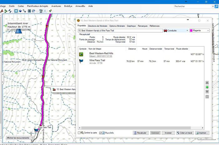
En utilisant Google Maps et en faisant une simulation d'un départ le 9 juillet de Los Angeles, si j'indique que je démarre à :
9 h > temps de conduite : 4 h 30
11 h > temps de conduite : 4 h 20
7 h > temps de conduite : 4 h 40 (dans ce dernier cas de figure, il ne me fait pas passer par la côte)
Googe Maps tient compte de la circulation et des routes fermées à la date et heure indiquées.
Si je rajoute 2 jours (soit 21), où puis-je les mettre?
Vous pouvez mettre un jour à Sedona.
Voici ce que nous avons fait à Sedona lors de notre dernier circuit :
voyageforum.com/...post=7612192#7612192
voyageforum.com/...post=7613495#7613495
voyageforum.com/...post=7615088#7615088
voyageforum.com/...post=7615259#7615259
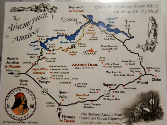
Avant d'aller à Sedona, vous pourriez faire un crochet sur l'Apache Trail :
Mais, au lieu de faire un aller-retour, vous passeriez par Payson pour rejoindre Sedona.
La première partie de l'Apache Trail :
voyageforum.com/...post=7672225#7672225
voyageforum.com/...post=7674046#7674046
voyageforum.com/...post=7675783#7675783
voyageforum.com/...post=7675828#7675828
En début de matinée, nous avons visité "Boyce Thompson Arboretum SP". Mais, je ne le vous propose pas parce que vous n'aurez pas le temps et, d'autre part, en été, il y fait très chaud.
Si vous êtes randonneurs, vous pouvez ajouter une journée à Zion NP.
Des idées de randonnées ici :
www.citrusmilo.com/zionguide/recommend.cfm
autre option :
un jour supplémentaire à Los Angeles et vous remontez la côte tranquillement en passant par Santa Barbara.
notre itinéraire sur la côte, à partir de ce message :
voyageforum.com/...post=7602862#7602862
Nous avons visité la côte dans le sens inverse de ce que vous avez l'intention de faire.
Dans MyMaps de Google on peut mettre des calques avec points d'intérêts ou itinéraire. En allant voir les détails de l'itinéraire, on voit le temps et la distance totale. Mais le nombre d'étape est aussi limité par calque. Il faut repartir sur plusieurs calques dont le nombre est aussi restreint.
En traçant mon itinéraire avec google maps il m'indique:"voie à accès limité" entre Riverkern et johnsondale en Californie (je vais de Ridgecrest à Visalia et…
Toujours à plancher sur mon itinéraire, je me demandais, si quelqu'un avait trouvé une méthode à peu près fiable, pour connaître le temps réel entre deux…
J'utilise habituellement googlemaps pour préparer mes itinéraires mais il y a un inconvénient: sauf erreur de ma part, il fonctionne en temps réel et tient…
Je me penche sur les application pour nous diriger pendant notre roadtrip, je ne suis pas très au fait de tout cela. ce que je sais c'est que nous n'aurons pas…
Hello! The itinerary is pretty much set for August 2026. Yeah, I know it’s gonna be *super* hot. But it’s the only time we can get away.
So, here’s the plan: Montpellier-CDG-Dallas.
Stay from July 31 to August 26, 2026:
Car rental – check,
Hotels – check,
Itinerary – almost check,
Photo gear – check,
Budget – check, 🤪
Meal planning – meh, we’ll see...
Walmart, of course, for the cooler when we arrive.
And now, without too much detail...
Fort Worth:
The Longhorns and the Stockyards;
JR’s ranch (for the missus);
Medal of Honor Museum – Arlington.
Houston and NASA Space Center:
See the Gulf of Mexico/America.
San Antonio and the missions.
Fort Stockton for an overnight stop.
El Paso via Guadalupe Mountains:
El Paso and White Sands.
Tucson and the Pima Air & Space Museum:
Tombstone, Bisbee.
Phoenix:
Still working on the program.
Sedona:
Round trip around the area via Flagstaff and Williams, or the Grand Canyon (already done) – we’ll decide on the spot.
Albuquerque:
Santa Fe,
Turquoise Trail,
Los Alamos.
Amarillo via Route 66:
Old Route 66 in the city;
Big Texas Ranch Steak 😏.
Dallas:
JFK Museum;
Perot Museum;
West End district.
And through it all – the road, the road, and more road!!!
We’ll adapt day by day based on our mental and physical state (we’re not exactly spring chickens).
Hello everyone! Really damaged due to flooding caused by runoff after forest fires (a total mess!), does anyone in this friendly forum have any updates on the Apache Trail between Apache Junction and Roosevelt Dam? Is there still a section of the road that’s tough to navigate?
We're leaving at the end of June and will be driving the route between Buffalo and Cody. We’ve already booked our accommodations and a rodeo in Cody, but during the day, we’ll be driving between the two and I’m unsure about the itinerary.
Which route do you think is the most pleasant, interesting, or scenic between:
- The northern route via Highway 14 with Sheridan, Lowell, etc.
- The southern route with Highways 16/20/14, passing by Loaf Mountain Overlook, Powder River Pass, Ten Sleep Canyon...
We’ll be in a car, so we should be able to drive on any road.
Thanks for your input!
I’m almost done planning our September road trip. After our 3-night visit to Sequoia, we’ll have a stopover night in Coalinga (to break up the drive). We’ll be staying two nights in Monterey and would like to stop along the way to visit one side of Pinnacles National Park. We’re torn between the West entrance and the East entrance, and we’d like to do a short hike of no more than 2 hours since we don’t want to arrive too late in Monterey.
This park is split into two distinct zones with no connection between them, and the mileage from Coalinga to Monterey is pretty much the same for both. Which area do you recommend visiting—east or west? And which route is the most scenic?
I’ve spotted two short hikes:
- East: Moses Spring to Rim Trail Loop
- West: Balconies Cliffs Cave Loop
Has anyone been there, or do you have another hike to suggest?
Thanks in advance, and have a great afternoon!
Marcalamar 🙂
After our first trip as a young couple to the West in 2007 (yes, that doesn’t make us any younger!), we’re planning to go back in 2028, but this time as a family of four! (We have two boys who’ll be 5½ and 13 years old in the summer of 2028.)
Our plan is to combine a few big cities (SF and LA, maybe San Diego) with national parks and state parks, mostly!
Ideally, we’d like to leave at the end of June and head back to France around July 19–20, so we can enjoy the first week of the Olympic Games in Los Angeles.
Since we already did the "loop" in 2007, there are must-see places we absolutely want to revisit—and especially share with our kids: Bryce Canyon, Yosemite, and above all, the Grand Canyon, which is still the most incredible thing I’ve ever seen on Earth!
On the other hand, some places didn’t leave a big impression on us for various reasons, so we’re not making them a priority: Antelope Canyon, Monument Valley, for example.
We’re planning ahead, but might as well be smart about it😏
Do you have any tips for a fun and doable itinerary over about 20–25 days with kids, without rushing?
Hi everyone! 🙂
Just a quick question about King Canyon and Sequoia National Park.
Before our night in Miramonte, we plan to visit King Canyon. The next stop will be two nights in Three Rivers to explore Sequoia National Park. I wanted to go all the way to Roaring River Falls on the King Canyon Scenic Byway and then turn back to head to Miramonte. Since we’re coming from Oakhurst, Google Maps says it’s 300 km and 5 hours of driving. Since we also want to hike to see the sequoias (Big Stump Area and Grand Grove) before tackling the King Canyon Scenic Byway, the timing’s going to be tight. How far do you recommend going before turning back to miss as few points of interest as possible on the King Canyon Scenic Byway? Thanks for your advice, and have a great evening!
Marcalamar 🙂
Hi everyone!
After years of hoping, waiting, planning, then changing, saving, and searching for the best possible route... we're FINALLY off this summer for a 5-week road trip in the West.
I had planned a trip to Colorado in 2021 but canceled due to COVID, so with time passing and my eldest’s high school graduation approaching fast, I figured it was now or never!
Anyway, the itinerary has been modified and extended to please everyone (I’m no longer the only one making decisions!!)
Here’s our final route:
Day 1 - 7/12/2026 - Brussels / Los Angeles
Day 2 - 7/13/2026 - Los Angeles
Day 3 - 7/14/2026 - Los Angeles
Day 4 - 7/15/2026 - Los Angeles
Day 5 - 7/16/2026 - Los Angeles
Day 6 - 7/17/2026 - Los Angeles / Kingman
Day 7 - 7/18/2026 - Kingman / Grand Canyon
Day 8 - 7/19/2026 - Grand Canyon / Page
Day 9 - 7/20/2026 - Page
Day 10 - 7/21/2026 - Page / Monument Valley
Day 11 - 7/22/2026 - Monument Valley / Durango
Day 12 - 7/23/2026 - Durango
Day 13 - 7/24/2026 - Durango
Day 14 - 7/25/2026 - Durango
Day 15 - 7/26/2026 - Durango / Glenwood Springs
Day 16 - 7/27/2026 - Glenwood Springs
Day 17 - 7/28/2026 - Glenwood Springs / Moab
Day 18 - 7/29/2026 - Moab
Day 19 - 7/30/2026 - Moab
Day 20 - 7/31/2026 - Moab
Day 21 - 8/1/2026 - Moab
Day 22 - 8/2/2026 - Moab / Vernal
Day 23 - 8/3/2026 - Vernal / Grand Teton
Day 24 - 8/4/2026 - Grand Teton
Day 25 - 8/5/2026 - Grand Teton / Cody
Day 26 - 8/6/2026 - Cody / Yellowstone
Day 27 - 8/7/2026 - Yellowstone
Day 28 - 8/8/2026 - Yellowstone
Day 29 - 8/9/2026 - Yellowstone
Day 30 - 8/10/2026 - Yellowstone / Salt Lake City
Day 31 - 8/11/2026 - Salt Lake City / Bryce Canyon
Day 32 - 8/12/2026 - Bryce Canyon / Zion
Day 33 - 8/13/2026 - Zion
Day 34 - 8/14/2026 - Zion
Day 35 - 8/15/2026 - Zion / Las Vegas
Day 36 - 8/16/2026 - Las Vegas
Day 37 - 8/17/2026 - Las Vegas / Los Angeles
Day 38 - 8/18/2026 - Los Angeles
Day 39 - 8/19/2026 - Los Angeles / Brussels
Day 40 - 8/20/2026 - Brussels / Home
We’ll be alternating between house swaps, motels, and campgrounds. I’ve booked all the accommodations (except the campground at Bryce since sunset bookings open only 14 days in advance) and the first activities, as well as the most touristy ones.
I’m currently putting together my day-by-day roadbook and having some trouble planning certain days, like in LA or Las Vegas. Choosing hikes isn’t easy either—it’s tough to decide!
We’re really excited but could definitely use your help with choices and optimizations!!
Hello.
I’d like to travel along I-15N from San Diego to Las Vegas with my mom, who’s 67. We’ve explored Northern California and the California Coast over the past two years and now want to continue through the desert.
There are several attractions along the way:
- Mormon Rocks
- Desert Discovery Center and visit the Old Woman meteorite
- Joshua Tree National Park
- Mojave Desert
- Mojave National Preserve
- Anza-Borrego Desert State Park
- Silverwood Lake
My mom has back issues that prevent her from hiking or walking on trails with elevation changes. Is it possible to visit these places by car, or are the routes flat enough?
I’d love for her to experience the desert with an itinerary adapted to her condition. I’m also open to other points of interest that aren’t mentioned. We have 3-4 days for the trip, so we’re not in a rush—just want to explore.
I’d love to take a road trip and visit Nova Scotia. I’d appreciate some info on the best cities to see and the most interesting spots. The trip should last about 10 to 15 days, staying in hotels or motels. Thanks in advance!
We’re being relocated to Saint Pierre and Miquelon.
We’ll be taking the flight from Nantes to Montreal and then from Montreal to Saint Pierre.
Could you recommend a hotel near the departure terminal that allows dogs?
Hi,
My 16-year-old son is flying to Grand Rapids with other kids his age. There’s a layover in Detroit. There’s no unaccompanied minor service available. Is it pretty easy to navigate Detroit Airport to catch the connecting flight to Grand Rapids (domestic flight)? There are several of them who speak English well.
Thanks for your replies,
Good evening, everyone! 🙂
Just a few last questions to wrap up our Lake Tahoe visit plans.
**Parking:**
We’d like to walk to Eagle Falls and then Eagle Lake. I’ve spotted two parking lots that seem close to each other and give access to the trailhead. Where and how do we pay for entry to Emerald Bay State Park and Inspiration Point?
**Viewpoints on the East Side:**
Are most of the viewpoints (Balancing Rock, Granite Cave, Bonsai Rock, etc.) right by the road, or do you have to hike to reach them?
**Donner Memorial State Park:**
Is it worth making a detour to Truckee to visit this park and the Truckee historic downtown?
Hi there. I'm shocked by the price of the Upper Antelope Canyon tour—$175 for less than an hour… You might say, "if you can’t afford it…" But the real question is whether it’s really worth it, because $350 for two makes me feel like I’m getting ripped off. For those who’ve done both Lower and Upper, can you tell me if the price difference is really justified? Thanks
Hi everyone! 🙂
As you can see, we're heading back from September 6th to the 27th.
Everything’s booked for September—flights, accommodations, and the car. As I plan, I’ll be asking the experts for help. This is our second trip to California, but most of the stops are new to us.
We’ll start directly from San Francisco to our first overnight stop, Davis, before heading to Lassen Volcanic Park for 4 nights. Our flight lands at 12:50 PM.
Here’s our itinerary:
Day 1: Davis – overnight stop
Day 2: Red Bluff – exploring Lassen Volcanic Park (scenic drive to Lake Helen)
Day 3: Susanville – scenic drive through the park via the South Entrance, points of interest, and hikes
Day 4: Susanville – Cinder Cone and Painted Dunes hike
Day 5: Susanville – Warner Valley (hikes)
Day 6: South Lake Tahoe
Day 7: South Lake Tahoe
Day 8: Mammoth Lake
Day 9: Mammoth Lake
Day 10: El Portal via Tioga Road
Day 11: El Portal
Day 12: El Portal
Day 13: Oakhurst
Day 14: Miramonte
Day 15: Three Rivers
Day 16: Three Rivers
Day 17: Coalinga
Day 18: Monterey
Day 19: Monterey
Day 20: San Francisco
Day 21: San Francisco
Day 22: Departure
For hikes in Lassen Volcanic Park, I’ve planned:
Bumpass Hell, Cold Boiling Lake (Day 2)
Paradise Meadow (maybe not going all the way), Devastated Area, and the loop around Reflection and Manzanita Lakes (Day 3)
Cinder Cone and Painted Dunes (Day 4)
Devil’s Kitchen and Boiling Spring Lake (Day 5)
I’ve read there are trails to access the trailheads for Cinder Cone (11 km) and Warner Valley. Are these easy trails for an SUV?
Are there any other must-see spots or things we shouldn’t miss?
That’s where I’m at for now. Thanks for your replies, and have a great evening!
Marcalamar 🙂
I’m a total USA addict. I’ve already done several road trips, including the East Coast and West Coast.
I’m here today because I’m planning to go back for another road trip on the West Coast. Possibly with one of my sisters and a couple of friends. It’s still just a plan for now, but I’m working on an itinerary in the meantime. Ideally, I’d leave in 2026, but I don’t have the exact dates yet—maybe April-May or September-October.
My last trip to the West Coast was in September 2014. We went for 2 weeks, but this time it’d be 3 weeks. What made me want to go back was simply a colleague who just left today. As I’m writing this, he’s on the plane. I’m so happy for him, but now all I can think about is going back.
Since I recently went to NY, I noticed that prices have really gone up. I assume the same is true for the West Coast? For 2 people over 3 weeks, what budget should I expect? We’re the type to watch our spending and find great tips.
I think we’ll arrive in San Francisco like the first time and leave from either Los Angeles or Las Vegas.
Merci de me conseiller pour la réservation pour la plus belle vue faut il réserver une chambre dans l'hôtel ou choisir une cabane ?
Prendre le petit déjeuner ou pas ?
Que pensez vous du restaurant ?
Hello, if the off-the-beaten-path enthusiasts are still around 😉, I’d love some info on tackling these trails. I’m not super familiar with the rules, risks, or what to expect—I’m looking for firsthand experience from folks who’ve done it on their own once or multiple times.
Hi everyone!
I’m planning a week-long family trip to NYC in October 2026. The focus is on museums and soaking up the New York vibe. I’ve been checking Airbnb, but the prices in Manhattan are through the roof. Since I don’t know NYC well, is it "wise" to look outside Manhattan? Any neighborhoods you’d recommend?
After our first trip to the West, we’d love to go back to see other must-see spots!
The stay would be from May 11 to 20, 2026—it’s short, but hey...
M11: Lyon to Las Vegas (overnight in Vegas)
T12: Route 66 – overnight in Grand Canyon (GC)
W13: Visit GC – overnight in Page
Th14: Visit Antelope Canyon / Horseshoe Bend – overnight in Monument Valley (MV)
F15: Visit MV – overnight in Moab
Sa16: Visit Arches / Dead Horse Point – overnight in Bryce
Su17: Visit Bryce – overnight in Zion
M18: Visit Zion / Valley of Fire – overnight in Vegas
Tu19: Return flight
What do you think? Could we add one more night somewhere? We’re not big hikers, so we’ll mostly explore the parks using shuttles.
Also, we’re all set—passports are good. Do you think one classic Visa card and one premium Visa card will be enough for coverage?
Thanks so much for your feedback, and happy holidays!
Hi North America forum crew,
Just a little post that might interest some of you:
Travelers to the United States | Photo Now Mandatory Upon Entry and Exit | La Presse
I assume many of you already know, but the America the Beautiful annual pass, which was $80, will increase to $250 starting January 1, 2026.
So if you're planning to travel before the end of December 2026, it's in your best interest to buy your pass in December 2025, since it will still cost $80 and be valid until the end of December 2026 if you purchase it in December 2025.
This price increase only applies to non-U.S. residents.
Additionally, for those who planned to visit just one park, a $100 surcharge per person will apply to access a list of 11 national parks...
For example, if there are 4 of you in a car, you’ll have to pay $35 + $400,
which comes to $435 to visit one of the 11 parks on the list (I don’t have all of them... Bryce, Zion, Grand Canyon, Yellowstone, Grand Teton, etc.).
Total madness.
The goal is to push people who only visit one park into buying the annual pass.
Last point: free entry days are over for non-residents!
Hi everyone, I’m traveling to Los Angeles and would like to rent a vehicle at the airport. However, I have a Boursobank Ultim deferred debit card, so I’d love to know if it’s possible for those who’ve experienced this recently. Thanks for the info!
I’m planning a week in S.F. in April 2026 and I can’t figure out how to tell the cable cars—of which I understand there are three lines—apart from the trams, which I think number seven. I can’t find their individual numbers or routes anywhere.
Could someone shed some light on this for me? Thanks in advance.
Wishing you all a Merry Christmas and a wonderful 2026 full of amazing travels.
Cheers,
Régine
Hi,
I’m planning a road trip through the American national parks starting from Denver in June 2026.
The price of the pass is jumping from 80 € to 250 € on January 1st, 2026!!!
Is it possible to buy the pass online before the end of the year to lock in the 80 € rate? If so, where and how do I go about it?
Thanks for your tips.
Arnale
I’m planning a road trip for July 2026 in northern Florida. Could you let me know if my itinerary makes sense?
Day 1: Orlando
Day 2: Amelia Island
Day 3: Amelia Island
Day 4: Tallahassee
Day 5: Panama City Beach
Day 6: Panama City Beach (visit to Destin)
Day 7: Crystal River (stop in Cedar Key on the way)
Day 8: Crystal River
Day 9: Anna Maria (stop in Clearwater)
Day 10: Anna Maria (St. Pete)
Day 11: Anna Maria
Day 12: Orlando
Day 13: Orlando
Day 14: Orlando
Day 15: Departure
We just finished 9 days in the American West and wanted to share our experience because we had an amazing time.
I know some of you might ask, why use an agency? Honestly, we didn’t really feel like doing all the driving and planning, especially since we didn’t know the area at all. And since our English isn’t great, having French-speaking guides was a big comfort.
We found Emmanuelle and Isabelle, and wow, they were fantastic. It was just the two of us with them, so it was a truly VIP, ultra-personalized experience. They treated us like royalty from start to finish. These two live in Las Vegas and know the region like the back of their hand. They told us they’ve spent over 15 years exploring every corner of the American West, and it really shows. Their knowledge of geology, park history, and local anecdotes is just impressive. It’s nothing like someone reciting a memorized script. They answer all your questions and really adapt to what you want to see or do.
What we really loved: the vehicle was super comfortable, and the little details made a difference—like snacks and even a homemade cake! Though, to be fair, we devoured the cake right away, so that counts.
Since they know the sites inside out, they took us at the right times to avoid crowds. So we could enjoy peaceful picnics at Grand Canyon viewpoints without being packed in with 200 people. Plus, on top of the must-see spots, they showed us some hidden gems that were absolutely stunning—places we never would’ve found on our own. They’re true locals who know all the best tips.
The service was really personalized. They adapted to our pace and preferences, and we could stop whenever we wanted to take photos. It’s the luxury of being in a small private group—you’re not just a number on a big bus.
In short, we really felt like we were traveling with friends rather than professional guides. Everything’s included in the price (hotel pickup, meals, park entries, etc.), so the value for money is fair.
We loved it so much that we’re already planning to come back next year to explore other areas with them. I think we’ve caught the American West bug—it’s all we can think about, and we can’t wait to return.
If you’re looking for a French-speaking tour with real personalized service and guides who know the region like no one else, we highly recommend them. We had unforgettable moments. They also design road trips for those who don’t want a guide. And they handled our hotel reservations in Las Vegas too. If you want genuine advice from friendly locals, we’re giving them a 200% recommendation!
I’m currently looking for well-located hotels near points of interest in the cities below. I’ve found a few, but the prices are really high.
Could any of you share some great addresses in the following cities?
- Los Angeles
- Las Vegas
- San Francisco
Also, do you have a preferred airline for domestic flights? If so, which one?