Bonjour à toutes et tous,
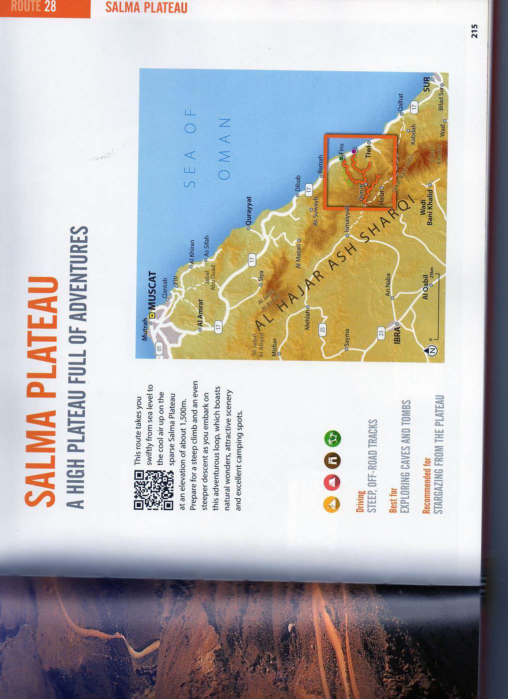
Nous partons à Oman en fin d'année et travaillons sur certains itinéraires. En particulier l'accès au plateau de Salmah. Gilfov avait conseillé (mars 2013) de ne pas boucler, d'éviter le départ à partir de Fins et de faire l'aller-retour par White Beach. Je souhaiterais savoir si quelqu'un a emprunté la piste 😛 qui, sur cette route 20 de Oman Off Road, part du village de Qurran pour rejoindre Ash Shariq (nord-ouest) pour rejoindre ensuite la route qui va à Ibra. Nous envisageons, bien entendu, de louer un 4x4. J'ai vu cette piste sur une carte routière et souhaiterais savoir dans quelle état elle est et si elle est praticable.
J'attends le plaisir de vous lire.
Bonjour,
vous souhaitez faire la traversée du plateau, si je comprends bien ?
Montez par White Beach, puis direction Quran, puis traversée vers l'ouest (vous avez dit vers le nord-ouest? et vous avez cité Ash Shariq mais je ne vois pas où c'est), on redescend finalement vers la route d'Ibra.
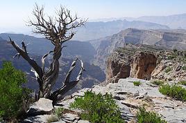
Parcours absolument superbe et sans difficulté particulière, la piste est globalement en bon état. La partie la plus impressionnante est sans doute la montée très raide au départ de la côte.
Merci beaucoup Pichteuk pour ces précisions. En effet, l'objet est de partir de la côte pour rejoindre Ibra par le plateau. Sur la carte dont je dispose, Ash Shariq est le village où la piste et la route pour Ibra se rejoignent. Merci encore de mettre votre connaissance du lieu à la disposition de tous 😄
Effectivement, c'est une route praticable. Du côté de la côte il y a un point de départ à hauteur de Fins, un autre 4km avant le wadi Shab (en venant de Mascate) et un troisième à hauteur de Qalhat - ce dernier passant plus au Sud du plateau de Salmah proprement dit mais avec une piste peut-être en meilleur état.
Ca fait une longue journée si vous comptez rejoindre Ibra dans la même journée. Ca vaut le coup de prévoir un bivouac en route (il fait frais en hiver la-haut!).
A re-confirmer au dernier moment: s'il y a eu de fortes pluies qqs jours avant les pistes peuvent être en mauvais état.
Merci de votre réponse... Vous participez, en quelque sorte, à la préparation de notre voyage et si je comprends bien vous êtes sur place (!?)
Nous serons (normalement) à Sur, nous quitterons le matin pour Wadi Ash Shab & Tiwi (cf route 21 du off road) puis prendrons la route au départ de White Beach (je pense entre Wadi Shab et Fins) pour rejoindre le plateau de Salmah où nous passerons la nuit (merci pour la précision du froid). Nous reprendrons la route le lendemain matin pour Ibra, la destination finale étant Sinaw pour le marché des Bédouins du lendemain matin.
Merci encore et je reviendrai sur ce forum si j'ai de nouvelles interrogations !
Bonjour
Si vous quittez wadi SHAB et TIWI, prenez la première piste sur votre gauche qui monte sur le plateau, c'est la plus accessible car en meilleur état que la seconde un peu plus loin.
Je vous mets en lien le fichier de l'itinéraire que vous pouvez ouvrir sur google earth puis ensuite le télécharger sur un GPS si vous le souhaitez.
Très belle traversée mais à éviter si le ciel se charge car les orages sont violents là haut.
J'ai fait ce parcours plusieurs fois, et beau bivouac à proximité des tombes ancestrales en bord de piste.
Bonjour,
Merci pour votre message. Si je comprends bien, le plateau est accessible à partir de wadi SHAB et TIWI et pas uniquement à partir de la route 20 du OOR (dans un sens ou dans l'autre et selon vous plutôt éviter un départ de FINS) ? (le lien annoncé du parcours n'est pas joint 🤪).
Merci de votre aide.
Puisque vous avez l'OOR, ça va être facile, la route 20 fait une boucle en passant sur le plateau de SALMAH.
Sur l'OOR, l'itinéraire décrit part de FINS et se termine 6 kms plus loin sur la route MUSCAT / SUR, donc normalement vous terminez cet itinéraire plus près de Wadi Shab.
Pour monter sur le plateau, je vous conseille de monter en sens inverse du circuit proposé par l'OOR, la piste est plus facile. De plus, la jonction avec l'itinéraire que je vous ai envoyé pour faire la traversée se fait au village de QURRAN (étiquette n° 6 sur votre OOR en page 238), donc au plus près de votre départ en bord de mer.
Désolé, on ne peut pas envoyer via ce site de fichier GPS ou google earth uniquement des photos. Si vous le souhaitez envoyez moi votre adresse mail et je vous envoie les points bivouacs et la trace pour la traversée au départ de QURRAN.
Concernant Mascate, j'y ai habité donc je n'ai pas fait attention aux possibilités de logement mais on trouve de tout, avec un rapport qualité prix pas toujours au top. Il y a quelques maison d'hôtes pas mal en tout cas, à voir sur booking.com.
J'ai des amis qui ont séjourné dans ces maisons d'hôtes qui ont été satisfaits. Ensuite, tout dépend du quartier où vous souhaitez vous poser, Mascate est une ville très étendue le long de la côte.
Lorsque je suis allé à Salalah, j'ai séjourné au Salalah Rotana Resort, très bel hôtel, grande piscine et construit très récemment. L'un des meilleurs rapport qualité prix dans le coin.
Je n'ai jamais séjourné à SUR, lorsque j'étais dans le coin, je me posais à "Turtle Beach Resort" à Raz Al Hadd !!! Seul camp où l'on peut se baigner tranquille (petite plage privée) et se rendre ensuite à Raz al Jinz pour voir les tortues au centre.
Bonne balade en OMAN
Bonsoir,
Merci beaucoup pour tous ces renseignements et les envois, bivouac et trace. J'avais vu cette piste sur la carte routière dont je dispose, vos informations confirment que nous prendrons ce chemin et que nous dormirons en route, si le temps de permet.
Merci encore et bonne soirée.
Bonjour à tous, je pars avec mes enfants en février et suis en pleine préparation de notre itinéraire. Je pensais aussi traverser le plateau de Salmah.
Je serais très intéressé par vos repères Google earth et cartes car malheureusement, le OOF est introuvable ici :-( ...
Et franchement, j'ai acheté le Lonely ... nul de chez nul ... très peu de cartes.
Un gros merci d'avance
Visitez mon site Woueb : http://philwoodrama.free.fr
L'avantage d'être intelligent, c'est qu'on peut toujours faire l'imbécile, alors que l'inverse est totalement impossible
Bonsoir Phil
Suis aussi en plein préparatif pour notre départ fin janvier.
J'ai le OOR , je veux bien te scanner les pages du Plateau de Salmah mais faut que tu me donnes ton mail car sinon je ne sais pas faire sur VF.
Infos :
1/ Va sur site : myoffroad.net
Circuit Plateau de Salmah, vidéo des pistes sur YouTube et autres renseignements.
2/ YouTube plateau de salmah . Plusieurs vidéo où tu vois la piste, les points de repères et la façon de l'aborder.
J'attends ton mail en MP pour t'envoyer scan du OOR pages du Plateau de Salma.
J'allais vous proposer le scan du OOF pour la route n°20. Cette route nous ne l'avons faite qu'en partie de la manière suivante : nous ne sommes pas partis de Fins mais de la piste qu'il y a entre Fins et Tiwi. Nous l'avons suivi jusqu'à l'intersection (village de Quran ou Qurun) où la piste redescend vers Fins. Là nous avons continué une piste qui mène au village de Ismaiyyah avant de redescendre à Ibra. Cette piste n'était pas indiquée sur le OOR 2014 et j'ai obtenu les informations sur ce forum (voir mes messages précédents). Les pistes sont entretenues, parfois vertigineuses et magnifiques, un 4x4 est nécessaire (selon nous).
Nous disposons aujourd'hui du dernier OOR (édition 2015). Sur cet OOR, il y a une nouvelle route, la route 30, qui part de Qalhat (sud de Tiwi) et qui rejoint la route que nous avions prise.
Sur ce forum, j'ai fait un retour d'information sur notre voyage. Il date du 25 juin 2016 et s'intitule "Retour d'expérience et infos pratiques Oman, décembre 2015/janvier 2016".
Dites-moi si vous souhaitez des scan de circuits... et bonne préparation !
Un grand merci pour les scans et les liens !
Je suis vraiment déçu de ne pas pourvoir me procurer le OOF avant de partir :-(
Il est dispo sur amazon ... à 153 € 🤪
Sinon, pour ceux qui ne connaissent pas, il y a l'application "maps me" qui est génial et qui permet de télécharger les cartes sur son téléphone pour les consulter hors ligne. Elle fonctionne bien sur avec le GPS du tel. Celle d'Oman a l'air très précise. J'utilise cette application dans tous mes voyages et je ne pourrais plus m'en passer. Le GPS, ça change la vie quand on est à l'étranger ( et même chez nous !)
Visitez mon site Woueb : http://philwoodrama.free.fr
L'avantage d'être intelligent, c'est qu'on peut toujours faire l'imbécile, alors que l'inverse est totalement impossible
Visitez mon site Woueb : http://philwoodrama.free.fr
L'avantage d'être intelligent, c'est qu'on peut toujours faire l'imbécile, alors que l'inverse est totalement impossible
Bonjour Phil,
Il ne faut pas désespérer de trouver le OOR sur place. Nous, la dernière édition, nous l'avions vue à l'aéroport de Mascate et à Nizwa dans un magasin de cartes postales, livres... sous les arcades, à un prix tout à fait compétitif, certes en janvier dernier...
Puisque vous avez l'OOR, ça va être facile, la route 20 fait une boucle en passant sur le plateau de SALMAH.
Sur l'OOR, l'itinéraire décrit part de FINS et se termine 6 kms plus loin sur la route MUSCAT / SUR, donc normalement vous terminez cet itinéraire plus près de Wadi Shab.
Pour monter sur le plateau, je vous conseille de monter en sens inverse du circuit proposé par l'OOR, la piste est plus facile. De plus, la jonction avec l'itinéraire que je vous ai envoyé pour faire la traversée se fait au village de QURRAN (étiquette n° 6 sur votre OOR en page 238), donc au plus près de votre départ en bord de mer.
Désolé, on ne peut pas envoyer via ce site de fichier GPS ou google earth uniquement des photos. Si vous le souhaitez envoyez moi votre adresse mail et je vous envoie les points bivouacs et la trace pour la traversée au départ de QURRAN.
A votre dispo
Gilles
bonjour je suis interesse pour les point bivouacs, merci gogo
Je profite de ce message pour remercier vivement Gilfov de l'aide qu'il nous a apportée à l'organisation de votre voyage 2015/2016. Ses informations nous ont été précieuses.
Gogo, à défaut de trouver la dernière version de l'OOR, nous pouvons, si vous le souhaitez, vous envoyer les scans de certains itinéraires en particulier la traversée du plateau. Pour cela, vous devez nous communiquer votre mail car nous ne pouvons pas le faire sur ce site !
Je serai à Oman début mars 2025. J'ai loué un 4x4 pour rejoindre la cote de la mer d'Oman depuis Ibra. J'ai 2 solutions vu sur Oman Off Road: La route OOR 30…
Je voudrais savoir quelle route faut il emprunter pour rejoindre les Wahiba Sands depuis le plateau de Sayq? J'ai bien compris qu'il fallait rejoindre Ibra,…
Hi there,
We’ll be traveling in January 2027 in a 4x4 with a rooftop tent with our three kids, from Johannesburg to Cape Town. We’ve already booked several campsites in national parks (Golden Gate / Mountain Zebra / Addo Elephant / Garden Route).
We still need to reserve the stretch between De Hoop Nature Reserve and Cape Town. Any suggestions?
We’d love to stay around Cape Town for 5 days to explore the wine route, the peninsula, and do some hikes in Table Mountain.
Any camping recommendations? Or, on the contrary, places to avoid?
Also, we have 2 nights left near Wilderness National Park / Knysna. Any recommendations?
Thanks so much for your help!
For my 60th birthday (yes, I’m jumping the gun a bit!), I’m starting to plan a self-drive trip to Tanzania (in June).
I also considered Zimbabwe but I’m worried it might be a bit chilly at night in June.
I’ve revisited an itinerary I’d thought about before, tweaking it since I’ll have more days to dedicate to this trip. Still no big northern classics for the same reasons as before (too expensive, too crowded, too many tour operators).
Here’s what I’ve got so far:
(Arrival/departure from Kilimanjaro Airport)
Night 1: Arusha
Night 2: Arusha
Night 3: Lake Manyara
Night 4: On the way to Iringa (any ideas???)
Night 5: Iringa
Nights 6–8: Ruaha NP
Nights 9–10: Mikumi NP
Night 11: Bagamoyo
Nights 12–15: Beach
Nights 16–17: Lushoto
Nights 18–19: Mkomazi NP
Night 20: Toward Marangu – eastern Kilimanjaro
Night 21: Western Kilimanjaro
End of trip
All your ideas, tweaks, info, and suggestions on this route are welcome!
I could move one beach night somewhere else if needed.
Also, if you have a car rental company to recommend or thoughts on the bandas rented in the parks, I’m all ears!
Finally, what are the roads like in Ruaha in June? The rental company I’m looking at seems to allow this park with a small 4x4. (Off-limits: Serengeti and Natron)
We’re planning a long-term trip starting in April with our 4x4, beginning in the USA.
We’re still looking for car insurance that covers Canada and the USA.
We’ve read quite a few forums, but we’re hoping for some help (from fellow travelers).
Hi there,
I’m planning a trip to Russia and Mongolia, starting from France.
Crossing the border at Poland/Belarus or Georgia/Russia—other borders seem either closed or complicated.
Tourist visas for 3 months with multiple entries.
Do you have any info on Russian companies that cover a 4x4 vehicle for 3 months, and what prices in rubles or euros you’ve paid?
Which bank did you use for expenses? (EuroMastercard and Visa cards no longer work.)
Regarding Russian SIM cards, a new system called "Gosuslugi" has been introduced. How long did it take you to get one, and what steps did you follow?
Hi,
we’re planning to visit a park again.
Could you point us toward the camps in Gonarezhou Park?
>We’re traveling completely self-sufficiently.
We love wildlife.
Thanks for any tips you can share!
JP
Hi there, we’ll be in Mozambique in early December 2026 and we’d like to travel from Vilanculos to Beira by car or bus to reach Beira airport. After that, we’re planning to visit Gorongosa National Park before flying back to France from Beira. From what we’ve heard, the road to Beira is tricky, especially at this time of year (start of the rainy season). Could anyone share their thoughts or suggest a solution? Thanks so much for your help!
Anne
Hi there,
I’m heading to Lesotho in a few days and I’m struggling to find info on the best route between Katse Dam and Sehlathebe National Park. There’s a fairly "direct" route from Thaba Tseka, but the roads seem rough, and we’re not exactly 4x4 pros. Anyone have any tips to share? Thanks!
Hi everyone,
We’re heading to Mozambique in October and are looking for either a 4x4 or 4x2 rental in Maputo, or a driver transfer option to reach:
- Ponta Do Ouro
- Tofo
- Vilankulos
The idea is to be self-sufficient for sightseeing and stops while still being able to access certain lodges or beaches that require a 4x2.
Do you have any contacts, addresses, or ideas to share?
Thanks in advance,
Hello,
We're hitting the road again in 2027 to discover new countries and cultures.
Could anyone give me some tips on driving from Ulaanbaatar to Lake Baikal and the route to take?
Thanks, and safe travels to those who are setting off!
We’re planning a 4x4 trip from Belgium to Central Asia, passing through Georgia, Russia, Uzbekistan, Kazakhstan, and Kyrgyzstan.
For these countries, our national insurance obviously doesn’t cover the vehicle, so we’ll need to get local insurance.
Will it be a problem if the vehicle is registered under person A and the national insurance is under person B? Both A and B will be in the vehicle, and both will be listed as drivers on the insurance.
When we get the local insurance, if we again list A and B as drivers, does the order matter? Could we get stuck at the border for this reason?
Hi,
For those who’ve driven on Iceland’s gravel roads in their own or a rented Duster, could you tell me what tires were fitted on the vehicle?
Were they All Terrain tires or more "standard" ones like all-season tires, for example?
Follow-up question: if they were "standard" tires, did that cause any issues on the gravel roads and rough terrain?
Thanks so much for any info you can share.
Best,
Marc
Hi there,
I'm planning a 4x4 road trip from Darwin to Broome with a rooftop tent in July 2026.
I'd like to know if I need to book overnight stops in advance or if I can just wing it and stop wherever I feel like it?
Some evenings, we'd like to stop and make use of campsite facilities (restaurant, shop, showers, toilets).
What do you recommend?
Do I need a permit?
My rough itinerary looks like this:
Darwin - Kakadu
Kakadu - Nitmiluk
Nitmiluk - Kununurra
Kununurra - Purnululu
Purnululu - El Questro
El Questro - Mt Elizabeth - Bell Gorge - Broome
I’m planning a trip to Iceland for next July-August, with a car and tent, and I’m wondering about booking campsites.
From your experience, is it necessary or even essential to book campsites in advance, or do you always manage to find a spot to pitch your tent?
We’ll also have the option to sleep in the car without pitching the tent.
Does that give us the flexibility to stay outside a campsite for a night here and there?
Hi,
I’m planning a road trip in the Middle Atlas, starting and ending in Fez and heading down to the south of Midelt, the Assoul Massif.... We’ll be traveling with two small 4x4s.
I’m looking for detailed maps of this region that include small roads and tracks.
Last year, we had a fantastic road trip in the Anti-Atlas and High Atlas using Erfahren maps, but unfortunately, they don’t cover the area we’re interested in this year.
Thanks for your suggestions!
Dominique
We’re planning a 13-day family road trip in Morocco this July, with six people in a Toyota Prado 4x4 (renting in Marrakech).
We’ll alternate between bivouacking and small hotels/riads depending on the stops.
Here’s the planned route (in this order):
Marrakech
→ Ouarzazate
→ Draa Valley
→ Zagora
→ Erg Chegaga
→ Lake Iriki
→ Foum Zguid
→ Tata
→ Tafraoute
→ Aït Mansour
→ Tiznit
→ Mirleft
→ Taroudant
→ Back to Marrakech
Our goal:
Atlas Mountains + desert + dunes + plateaus + valleys + a bit of coastline.
We’ll cover about 1,700 km in total.
We’re planning:
Bivouacking in the Chegaga/Iriki area
Flexible for the rest (booking the day before or same day)
Sand gear: traction plates, compressor, tow strap, roof rack
Questions:
Is the Zagora → Chegaga → Iriki → Foum Zguid crossing in July doable on our own (single vehicle, no guide)?
Are there any truly technical or risky sections between Chegaga and Iriki?
Does the overall itinerary seem manageable in 13 days without rushing?
Any suggestions for great bivouac spots or particularly interesting stops along this route?
The points on the route are provisional overnight stops. Some spots will include two nights in the same area.
We’re used to off-road driving, but not yet in the Moroccan desert.
Thanks in advance for your feedback and tips! 😊
Good evening
I could use some advice 🙂
Our trip to Namibia is planned for June/July 2026.
We’re struggling a bit with timing and choosing activities for the part of the trip between Sesriem and Brandberg.
Day 1: Sesriem to Mirabib
Day 2: Mirabib to Swakopmund – visit Swakopmund, overnight in Swakopmund
Day 3: Sandwich Harbour – overnight in Swakopmund
Day 4: Kayaking with the seals + the living dunes – overnight in Swakopmund
Day 5: Moon Landscape, Henties Bay + Cape Cross – overnight at White Lady Lodge in Brandberg
Does this itinerary seem realistic to you? Is Cape Cross really worth the trip? If I had to choose between Cape Cross and kayaking with the seals, which would you recommend?
Thanks in advance for your help!
Hélix
My son and I are heading to Georgia this summer to explore the High Caucasus (Svaneti, Kazbek, and Tusheti regions). For this, we’re planning to rent a 4x4.
However, the rental agencies we’ve found prohibit driving on the tracks to Omalo (Tusheti) and/or Ushguli (Svaneti).
Do you know of any agencies in Tbilisi (local and reliable) that allow rented 4x4s to drive on these tracks? If so, which ones?
Hi everyone,
I’m starting to plan an itinerary for September 2027 focused on Zimbabwe and Zambia. I’d love to visit Gonarezhou National Park—I see there are two sectors: the Mwenezi Region in the south and the area around the Runde River in the north. Should I cover both sectors or just focus on the northern region?
For the parks along the Zambezi River, is it better to visit Mana Pools on the Zimbabwe side or Lower Zambezi on the Zambia side?
Thanks in advance for any tips on the parks in these two countries.
Have a great day, everyone.
We’re spending 18 days in New Zealand from 05/04 to 05/21, arriving in QUEENSTOWN and leaving from AUCKLAND.
Any ideas for a road trip that covers the highlights of both islands but only changes hotels every 3–4 nights?
Thanks.
For our trip to Georgia in July, I’d like to rent a 4x4 starting from Tbilisi.
Do you have any rental companies to recommend?
The traditional rentals like Hertz, Avis, etc. seem way overpriced compared to local companies—what do you think? Are they properly insured?
Has anyone here tried Geo Rent Car, Auto 4 Rental, or Sur Price?
Also, I’m looking for info on the condition of the Ushguli–Lentekhi track—is it passable?
Hi everyone,
A well-prepped 4x4, a travel plan across Africa in stages since I’ve got kids to see regularly and work to earn a living.
I’m leaving in November for about a month with the goal of reaching Senegal via Mauritania. I’d love to share this trip with someone who wants to discover Mauritania and a bit of Senegal... and also experience life on board a 4x4 in the desert or bush, sometimes sleeping in the vehicle or in hostels/small hotels for comfort. I want to share this rediscovery because two’s better than one!
Just traveling, exploring, and living! !
I’m planning to explore Argentine and Chilean Patagonia for a month in December 2019.
I’m looking for a rental company (or several) that offers single-cab 4x4 pick-ups with a fitted camper cell for two people. I’m specifically after a vehicle with an indoor shower for extra comfort ;)
So, no vans—at least not from the rental companies I’ve seen so far.
While browsing the forum, I came across the Chilean rental company Holiday Rent. But do you have any recommendations for Argentine rentals?
Because, if I can’t return the vehicle in the same city as pickup, I’d prefer—and it’d likely be cheaper—to at least return it in the same country.
I’m traveling through Argentina and Chile (as well as Paraguay and Uruguay) with a 2019 Toyota Hilux Euro 6. Could anyone tell me if the local diesel is suitable for its engine, or if I need to take any special precautions (like adding an additive, for example) for these countries?
I’d also like to know if driving at high altitudes is possible, and up to what elevation—or if I should worry about the vehicle going into limp mode?
If that happens, what should I do?
Hi there,
Can you tell me if the road between Zagora and M'Gouna is easy or difficult for a 4x4? How much time and how many kilometers should I plan for? I’m traveling in May.
Thanks!
Hi there,
My trip to South Africa is starting to take shape.
However, I'm struggling to figure out the route through Kruger Park. I can't seem to find the information I need about getting around.
Coming from the south, I plan to arrive on Day 1 in the early afternoon at Malelane or Crocodile Bridge.
Do some shopping in Malelane (or Crocodile Bridge main area) and stay overnight outside the park.
Leave on Day 2 at 5 AM for the park. Explore the southern part of the park.
Stay overnight around Skukuza or Lower Sabie. (We don’t want to stay in one of the park’s big camps. We’re looking for a lodge around 200 €.
Head out on Day 3 for a self-drive safari, maybe as far as Orpen.
We’d like to stay in a private reserve on nights 4 and 5.
We’re not sure which one or how to get into a private reserve. Do we need to exit Kruger Park?
On Day 5, we’d like to leave to visit Blyde Canyon (on Day 6).
I’m planning to leave Morocco for the summer but want to leave my 4x4 there to avoid exceeding the famous 6-month limit. I’d like to park it in one of the two Spanish enclaves (Ceuta or Melilla).
Does anyone know of people or companies that handle long-term parking (preferably secure) in either place?
Once the car is parked, what’s the best way to get back to France using public transport?
Is the nearest airport Tanger from Ceuta?...
How do I get there easily, etc. etc.
hello! I’d like to go to Kazakhstan and rent a fitted 4x4 locally so I can drive off-road trails and sleep inside the vehicle... could anyone share some local rental company addresses, please? Thanks! !