Coucou à tous amis voyageur! 🙂
Alors je me lance, j'ai un problème je comprend rien! lol
Cela fait plusieurs jours que je fouine le net (francophone et anglophone) et voila que j'ai des infos contradictoire, bref je visualise pas le "truc"!🤪
Finalement le fameux trail de buckskin gulch c'est lequel?
trek 1 :Wire pass trailhead (ou buckskin Gulch trailhead) j'usqua white house trailhead? ou
trek 2 : Wire pass trailhead jusqu'a lee's ferry?
Parce que certain font le trek 1 en un jour d'autre en 2 en dormant à la confluence, qu'en est il réellement?
Pour le trek 2 certains l'on fait en 2 jours en dormant au millieu du trail (bien apres la confluence) et d'autre le fond en 4 jours avec 1ere nuit a la confluence, 2eme au millieu et une troisieme nuit vers la fin du trail avant de rejoindre lees ferry!
Du coup je suis embrouiller combien d'heures (environ) prend chaque tronçon? par exemple de wire pass trailhead à la confluence? de la confluence a white house? de la confluence jusquau camping du millieu et camping millieu jusque lee ferry?
Je sais pas si vous comprenez bien ce que je comprend pas, 🤪 je suis désolée j'ai du mal à formuler mon problème! 😕
Ps : jai deja parcouru tout les forums de VF de A a Z sur le sujet!
Un grand merci à tout ceux qui prendront la peine de m'expliquer!🙂
Merci, merci, merci, merci! 😉
Si je comprend bien buckskin gulch est un affluent de la paria river.ok.Donc d'apres les cartes en prenant le wire pass trail ON EST dans buckskin gulch? Du coup pourquoi sur les forums les voyageurs disent "je prend le wire pass trail pour rejoinde buckskin gulch au confluent"? (je traduis peut être tres mal voila le probleme)😊
"jai deja parcouru tout les forums de VF de A a Z sur le sujet! "
Le sujet a pourtant déjà été évoqué... c'est que tu n'es pas tombé sur les bons topics (il est vrai aussi que qd on tape Buckskin Gulch ds la fonction "recherche" du forum , on tombe sur des dizaines et des dizaines de topics... ce qui noie les les infos que tu recherches🤪)
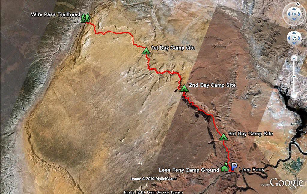
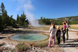
Tout en haut à gauche sur cette carte, tu vois le début du Buckskin Gulch qui coupe la piste House Rock Valley rd (celle qui mène à Edmaier Secret, à CBN , CBS et White Pocket)
(ce passage sur cette piste est d'ailleurs parfois très difficile à passer qd le wash du Buckskin Gulch est plein d'eau ou de boue, ce qui arrive en cas de fortes pluies)
C'est de là que démarre le trail (qui suit le Buckskin Gulch) menant à Edmaier Secret (voir ouestusa)
Si tu continues 4 miles plus loin sur la House Rock Valley Rd (en bas à gauche sur la carte topo) , tu arrives à Wire Pass trailhead.
Pour traverser Wire Pass, il fautcompter1,7 mi/2,7Km en one way, puis on arrive à la confluence Wire Pass/ Buckskin Gulch dont la partie slot canyon fait11,8 mi /19Km en one-way.
Pour avoir un bon aperçu de ce slot canyon en une demi-journée, il est conseillé faire les 1,7mi /2,7Km ds Wire Pass, + 2mi/3Km ds Buckskin Gulch
(ce qui correspond en tout à 11,5 km/ 4 h00 A-R) .
Le trail commence donc au parking de Wire Pass où il faut prendre un permis libre service, non limité en nombre (pour une rando d’1 jour), en utilisant une enveloppe disponible sur place et y glisser un billet de 5$
On suit le lit sec du wash Wire Pass pendant 1,7 mi. Après+/-1 mi, on atteint les premiers narrows. Ces narrows sont assez faciles : parfois (selon la façon dont le dernier flash flood a affecté le canyon), il est nécessaire d’escalader des éboulis de 2 m de haut pour passer à la 2ème section de narrows, mais ce n’est jamais insurmontable (et il existe un contournement par les hauteurs si c'est nécessaire).
Après 1,7 mi, on arrive alors à la confluence Wire Pass/Buckskin Gulch , au point GPS 37°01’11.6’’N, 112°00’10’’ W (présence de quelques petits pétroglyphes à la base d’une large alcôve sur la droite )
On peut alors suivre le Buckskin Gulch vers l’aval autant que l'on veut, pour autant qu'on dispose de bcp de temps... Pour le faire en entier (12mi/19 Km), il faut obligatoirement demander plusieurs jours à l’avance , des wilderness permits-backcountry, à la Paria Station ou au BLM de Kanab, et prévoir 3 ou 5 jours, selon qu’à la confluence avec la Paria River, on décide de :
- remonter le Paria River Canyon vers le nord (7mi/11Km) pour rejoindre White House sur la Hwy 89,
- ou de le descendre (30 mi/50Km !!!) vers le sud pour rejoindre le Colorado à Lee’s Ferry (sur la Hwy 89 A).
Il faut savoir qu’à mi-chemin dans le slot canyon Buckskin Gulch, il existe un sentier rudimentaire permettant de sortir de Buckskin Gulch, en cas de mauvais temps. C’est le seul sur toute la longueur du canyon (12 mi !!). Une fois engagé plus loin, tout espoir de sortir vivant doit être abandonné , en cas de brusques montées des eaux !!!! Et si on veut faire la rando en entier, c’est là qu’il faut camper, car, en plus de la sortie de secours, les berges sont, à cet endroit, surélevées par rapport au lit de la rivière et de ce fait, rarement inondées en cas de flash flood.
Période conseillée : printemps pour éviter les orages plus fréquents en été
Ouest USA 2009 https://voyageforum.com/v.f?post=2800143#2800143
5ème trip USA, 09/2013 https://voyageforum.com/v.f?post=6186946#6186946
Moi non plus... mais si j'avais qq années de moins, je l'aurais peut-être envisagé (le problème, c'est qu'il manque qd même d'hôtel ds ce coin😄)
"Tu as pris des cours du soir en douce chez Philippe (Sedonax) ??? "
Bien sûr... Qd j'ai débuté en 2008, tout comme notre ami Nodivenofun , je n'arrivais pas non plus à m'y retrouver ds ttes ces confluences... Heureusement que Philippe était là pour répondre à ttes mes questions😏. Depuis j'ai pris des notes et j'ai trouvé les bonnes cartes qui expliquent tout très bien😛
"Bravo, c'est de la réponse de pro."
Je n'ai donc aucun mérite puisque je ne fais que rapporter les dires de Philippe😏
D'autant que je n'y suis pas encore allée: la rando de Buckskin Gulch m'a déjà échappé par 2 fois (en 2011 et en septembre dernier pour cause de mauvais temps: le slot canyon était rempli de boue🏴☠️)
Ouest USA 2009 https://voyageforum.com/v.f?post=2800143#2800143
5ème trip USA, 09/2013 https://voyageforum.com/v.f?post=6186946#6186946
Super explications Jacqueline (même si elles viennent d'abord de Sedonax 😉).
Mais j'ai une question peut-être bête par rapport à Buckskin Gulch : pourquoi démarrer la rando au Wire Pass Trailhead et pas au Buckskin Gulch Trailhead ?? Je me disais que ce dernier parking doit être plus facilement atteint que celui de Wire Pass, non ? Mais peut-être que démarrer la rando à partir de ce parking présente moins d'intérêt ??
"pourquoi démarrer la rando au Wire Pass Trailhead et pas au Buckskin Gulch Trailhead ?"
pcq c'est + court😏
Du Wire Pass trailhead à la confluence Wire Pass/Buckskin Gulch, il n'y a que 1,7 mi / 2,7 km
Du Buckskin Gulch trailhead à la confluence Wire Pass/Buckskin Gulch, il y a 7 km
Mais si tu démarres depuis le Buckskin Gulch trailhead, tu pourras en même temps visiter Edmaier's Secret😉
Il y a eu un topic assez récent là-dessus où ts les piliers du forum avaient participé (et où Alain-Pierre/ Isap29 avait fourni une carte très intéressante avec marquage des distances)
Ouest USA 2009 https://voyageforum.com/v.f?post=2800143#2800143
5ème trip USA, 09/2013 https://voyageforum.com/v.f?post=6186946#6186946
Oh lala!!! tout s'éclaire!!!! (bon j'ai du relire 4 fois en prenant des notes 😕) en fait il y 2 confluences!!! c'est ca au moins? en fait je comprenais rien car je croyais que la "grosse" confluence avec la paria river c'etait celle de buckskin! du coup plus je lisais moins je comprenais! ah que ca fait du bien!!!mdr! j'ai la tête qui chauffe depuis des jours! Je veux te dire un EEENNNOOORRRMMMEEE MMEERRCCIII!!!😄
Merci merci merci merci quelle rapidité et efficacité!🙂
Donc comme mon but c'etait de randonner avec une seule nuit dans le canyon je peut donc partir de wire pass trailhead dormir à la confluence paria canyon et revenir a white house campground (ou j'aurais laisser la voiture bien sur🙂)?avec ce trajet j'aurais bien fait le fameux slot de buckskin?
génial! reste qu'a s'occuper des permis!
Merci à vous tous pour votre intervention! mais vraiment grand merci Bastinj !😉
J'avais lu la douzaine de page de ce post mais je vais pouvoir relire en comprenant pour edmaeir's que du coup je comprenais pas non plus!😉
trop fort! merci merci!🙂
Donc comme mon but c'etait de randonner avec une seule nuit dans le canyon je peut donc partir de wire pass trailhead dormir à la confluence paria canyon et revenir a white house campground (ou j'aurais laisser la voiture bien sur🙂)?avec ce trajet j'aurais bien fait le fameux slot de buckskin?
Si tu ne veux faire qu'une seule nuit de camping dans le canyon c'est même la seule solution. En effet, la journée de Wire Pass à la confluence avec la Paria River sera déjà longue (tout dépend de l'eau et de la boue qu'il y aura, il y a 2 obstacles à passer : un "Jumble of rocks" où on s'aide généralement d'une corde et la "cessed pool" où il faut parfois nager ou avoir de l'eau jusqu'à la poitrine"), en venant du trailhead de Buckskin Gulch ce serait trop long (sauf à foncer) même en partant tôt.
La seconde journée pour aller à White House sera par contre nettement plus courte et, il faut bien l'avouer, seulement intéressante dans sa première partie car ensuite on marche dans un wash standard.
Personnellement, je 'ai fait que 2 balades aller/retour à la journée à Buckskin Gulch : une de Wire Pass en allant assez loin dans Buckskin Gulch et l'autre de White House trailhead jusqu'à environ 1 mile à l'intérieur de Buckskin Gulch.
Si vous n'avez pas 2 véhicules, il vous faudra un Shuttle le premier jour de White House Campground à Wire Pass, Paria Outpost propose cette prestation.
Ceci n'est qu'un complément car les forumeurs précédents t'ont parfaitement répondu, en particulier Bastinj 🙂 !
Philippe
www.phschuler.com et www.ouestusa.fr, pour une vision de l'Ouest en dehors des sentiers battus.
Carnet de voyage Ouest USA 2009
Wow Sedonax en personne!!!😊 Merci pour ce complément d‘infos!!! 🙂
Vous aviez pas trouvé top le white house trail alors...😐 vous pensez que cest plus sympas un aller retour a la journée? Ou plutôt le faire en 4 jours jusqu, a lees ferry?
Merkiiii🙂
Vous aviez pas trouvé top le white house trail alors...😐 vous pensez que cest plus sympas un aller retour a la journée? Ou plutôt le faire en 4 jours jusqu, a lees ferry?
Le plan sur 2 jours Wire Pass > White House me semble très bien, je voulais juste te signaler le fait que les 2 journées seraient inégales en terme de longueur (14 et 7) et d'intérêt (en ce qui concerne les 4 derniers milesde la randonnée ) mais ce n'est pas un problème en soi (pour agrémenter le 2ème jour tu peux soit descendre 1 heure dans Paria canyon après la confluence puis revenir à la confluence pour prendre le chemin de White House, ou bien tu peux rentrer directement à White House et si tu y arrives vers le milieu de la journée tu pourras faire autre chose dans l'après midi du style Edmaier's Secret par exemple).
Les 4 jours dans Paria Canyon de White House à Lee's Ferry c'est un autre type d'expérience, nettement plus "immersive" ou l'aventure compte autant que ce qu'on y voit. Laurent Martres l'a fait l'année dernière et pour les bons marcheurs qui ne voudraient camper qu'une seule nuit il conseillerait également l'aller/retour jusqu'à Big Spring (12 miles de White House).
Philippe
www.phschuler.com et www.ouestusa.fr, pour une vision de l'Ouest en dehors des sentiers battus.
Carnet de voyage Ouest USA 2009
Nous allons bientôt partir pour les USA (ce sera notre troisième voyage) et cette fois-ci ce sera sans enfant A nous donc la liberté et l'aventure!! Nous…
Nous partons en septembre pour un mois aux US, Arizona, Utah, Californie et cette fois j'aimerai avoir avec nous un GPS de randonnée, en effet certaines randos…
Je pars 1 mois dans l'ouest du 17/08 au 17/09 et je butte un peu sur la partie Grand Staircase Escalante. Nous serons deux et nous partons pour marcher,…
Il semblerait que se site si photogénique de canyonlands, l'un des plus beaux du parc, soit fermé suite a 2 actes de vandalisme sur ce lieu sacré. souhaitons…
A tous ceux qui envisagent la rando des White Domes en passant par Water canyon, la water canyon road est complètement effondrée (et donc complètement…
Hi,
We’re planning to do the 4-day trek from Mestia to Ushguli without an agency. The descriptions mention that there are accommodations at each stop, but we can’t find any details about them. Has anyone got info or feedback on this route?
We're planning to trek in Peru and Bolivia and would love to find some local agencies.
If you know any, could you share details on prices and, of course, the names of the agencies?
Which trek would you recommend?
Elocine
Je pars en autonomie totale sur un trek au Maroc (10jrs) Imilchil - Aghbalou.
Trouve t-on des cartouches gaz à vis (Coleman, Primus) à Marrakech (adresse) ou villages entre Imilchil - Aghbalou ?
Si non , trouve-t-on des cartouches Butagaz pour camping-gaz (petit volume 230 gr ...)
Merci d' avance pour vos réponses
Hello, I’d like to embark on a little trip in my home country, Switzerland. I’ll start walking from La Cure, heading toward Le Noirmont first, then I’ll improvise my route—but it’ll probably follow the French border... at least as far as Lac de Joux.
I’ll decide day by day how much farther to go after that. My goal is to stay in nature as much as possible, wander around for as long as I can, and restock food in villages or towns along the way.
I’m thinking of mostly camping, but we’ll see if I end up in a hotel or another campsite depending on my route.
I’d love to reach La Chaux-de-Fonds on foot... maybe even Delémont.
The whole thing should take about a week, give or take.
I’ll be bringing my dog, and I’m preparing for this as soon as I’m ready.
Any tips to make sure everything goes smoothly for us? Things I should know—or avoid? What about shepherds with their flocks of sheep? And isn’t hunting season open right now?
I’m not sure if what I’m planning is even doable, which is why I’m asking around.
This’ll be my first time doing something like this—wandering in nature *and* with a dog. I’m really excited for this adventure... and I need it. Thanks!
We’re really keen on ecosystems and want to hike in "natural" ancient forests—not planted woods or areas heavily degraded by human activity. Travel guides (like Lonely Planet) don’t provide much info on this. Could you point us to the most interesting spots?
Thanks in advance for your tips.
We wish you happy holidays and a fantastic 2026, full of discoveries!
Claire and Albert
Hi, this might not be the right section, but I’d like to know if it’s possible to start mountaineering with another person without necessarily hiring a guide. We’ve done quite a bit of hiking but not mountaineering—we’ll just do a half-day glacier course. After that, we were thinking of starting with La Grande Motte and the Pointe de la Traversière, which were recommended to us. Honestly, for things like roping up and knots, I’ll learn at home with lots of videos and a book.
Jaimerais savoir si quelqu'un aurait fait des treks sur le Ruwenzori et combien ça coute en moyenne, les infrastructures, les paysages la sécurité sur les lieux, merci beaucoup. J'attends avec impatience vos réponses.
We’re leaving in 9 days for a two-week trip to Madeira, mainly to hike.
From my research, I’ve found that since last year, access to most trails—and systematically for the most popular ones—is now paid. You have to pay an access fee of 4.50 € per person per classified hike in 2026, and even 10.50 € for the most iconic hike: Pico Arieiro to Pico Ruivo. When paying, you also have to choose a day and a 30-minute time slot for your start time. Of course, this reservation is neither changeable nor refundable, even if the weather that day is terrible.
Personally, given the massive influx of tourists to the island in recent years, I don’t mind paying a fee to help maintain the trails. Similarly, setting a limit on the number of people who can hike them per day is certainly preferable to preserve this priceless heritage.
However, what’s much less fair is that in reality, most of the available spots are reserved: 1/ for Madeira residents (which is normal); 2/ for "economic operators" (meaning local tour operators). For example, if you’re a non-resident (independent tourist), no booking is possible for the Pico Arieiro hike for an early morning start before September! So, unfortunately, we’ll have to skip this hike.
It’s the same issue for Ponta de São Lourenço, the 25 Fontes, Pico Ruivo... in short, all the most popular hikes. Oh well, we’ll skip those too!
So my question is: which hikes do you recommend where we won’t face the huge crowds that the others get? And where we can book the day before for the next day, taking the weather into account?
Finally, a quick accommodation question: we’ve booked the first week in Funchal, but I haven’t decided yet for the second week. Do you have any advice on where to stay in the south or north, preferably avoiding overly concrete-heavy and touristy spots?
I’m reposting about the logistics for Samaria Gorge.
I’d love to get recent info, especially about whether it’s possible to park my car in Omalos, do the hike, and then catch a bus back to my vehicle.
In theory, it’s doable, but when you check the KTEL website, there aren’t any feasible schedules listed. If anyone has recently organized this with reliable, verified details, I’d really appreciate it. Thanks in advance!
Hi there,
We’re flying from Montreal to Lyon this August to go hiking in the French Alps. We’ve rented a car and will be staying at campgrounds. We’re planning to do day hikes and want to stay a few days in one spot, do a few hikes, then move on to our next camping spot. Could you share your favorite spots or any recommendations for places to spend a few days with great hikes?
A few details:
We arrive in early August and leave in early September.
We’re looking for day hikes (or shorter), moderate difficulty, with a cumulative elevation gain of no more than 1000m, and of course, beautiful scenery!
We’d prefer not to drive too much—maybe it’s best not to head too far south and deal with unnecessary heat?
Along the same lines, if you know of any great campgrounds where we can start our hike directly without needing the car, we’d love to hear your suggestions!
Bonjour
Souhaitant faire de la randonnée sur cette île, je voudrais d'abord savoir quelle serait la période la plus favorable sachant que j'avais passé quelques jours en novembre 2018 pas pour cette activité mais plus pour une simple découverte de l'île et le temps n'était pas top notamment en montagne. Donc peut on choisir une organisation en étoile sachant que je louerai un véhicule avec éventuellement 2 points d'hébergement.
Je n'envisage pas d'intégrer une structure mais de partir à 2 et de s'organiser sauf si vous me conseillez une agence locale ou un guide local. Enfin même si je compte me procurer les différents supports, carte et topo guide plus gps je vous remercie de bien vouloir me communiquer les randos à faire en priorité
Merci beaucoup pour vos informations
I’m planning to do the Mercantour crossing following the Randoxygène route in mid-July.
I’m used to hiking in the mountains, but I sometimes get vertigo, for example on ridges with drops on both sides. I wanted to check if there are any T4 or T3-T4 sections and find out if there are any very exposed passages—and if so, where—so I can plan an alternative route.
Can anyone give me some info on this?
Thanks!
I’m planning a trip around Cap Corse and the AGRIATES in 2026, from May 8th to 15th (there are still 2 spots left, by the way! Just DM me if you're interested).
I’d love to know which hikes are worth prioritizing in the AGRIATES. We’ll be staying in SALECCIA for two days as our base—what should we focus on from there?
A round trip to IGNHU beach? Any other suggestions?
For Ostricano, I think it’s too far for a round trip...
Thanks for your tips!
Have a great day,
Anie, Toulouse
I’d like to get some info about the GR10 Pyrenees traverse. I need help planning the daily stages and accommodations—my wife isn’t an experienced hiker but walks a lot, so I’d like to schedule shorter walking days and thus a longer overall trip in terms of number of days.
Could anyone give me some help and advice?
Best regards,
New to this forum, I’m planning a pretty big project for 2028.
I’m heading to Nepal to do a trek from Kathmandu all the way to Everest Base Camp (a cool 5,300 m 😄).
This trek is a bit special because even though I’ll be part of a group, I’m going solo (so far, no problem—I’m used to it). But it’s my first real trek, and it’s also a humanitarian one: once I reach base camp, I’ll stay an extra week to help clean up the waste left by tens of thousands of climbers! Since I’m originally from South America, from two countries that share the Andes, I have a deep respect for mountains—they fascinate me. So Everest… it’s kind of the trip of a lifetime!
So, a little question for those who’ve done treks to Everest before… any tips for good mental preparation (I’m already working on the physical side)?
Hi there, I’m planning the Annapurna Circuit for March 2027 and I’m looking for a local agency with a local guide—preferably French-speaking—to arrange this trek for us. Any suggestions? Thanks
Hello!
We’re spending a few days in Toraja country at the end of May. We’d love to do a day trek—taking our time—on a route that’s stunning in terms of scenery, but not a level 5 in difficulty!
Any suggestions you can share, please?
Thanks in advance
I’d like to do the Mare a Mare Sud in May over 4 days. I’ve found quite a few places to stay along the route, but I’m stuck on the start and finish.
I’ll be arriving by plane on Sunday evening and would like to start pretty early on Monday morning. Ideally, accommodation right at the trailhead (Alzu di Gallina) would be amazing, but I can’t find anything. Any tips?
Also, for the transfer from Figari Airport to Porto Vecchio or Alzu di Gallina?
At the end, I’d like to pick up a rental car—any advice on that too?
I’m traveling solo by plane to Catania in May and plan to hike the northern side of Etna, starting from Linguaglossa where I’ll arrive by bus. After that, I’d love some info on how to get up to Piano Provenzana (shuttles or hitchhiking), since it seems there’s no public transport except in the summer. Can you sleep there in a free or cheap refuge, or camp? And how far up can you go without having to hire a guide? Thanks in advance. Bernard.
Bonjour a tous,
je pars en voyage au Maroc en aout et nous allons commencer par nous arrêter a Chefchaouen(nous sommes en voiture).
Ma question: quelqu'un peut il m'indiquer un itinéraire de rando en boucle d'entre 5 et 7 jours aux départ de Chefchaouen dans le parc de Talassemtane passant si possible par le pont de dieux?Ou un guide papier qui en reunis quelques uns?
Nous privilégions le camping sauvage et les gites.
Merci d'avance
Hi there, for those who’ve been recently—is it possible to find other solo travelers in March on the island to share transport or room costs? It doesn’t seem easy to travel on a budget.
If you have any recommendations for simple lodgings or places with dorms, I’d love to hear them.
For those who’ve done multi-day treks while moving around: do you need to bring your own sleeping bag? I’d love to hear about itineraries you’ve done without a guide, just with a map and GPS.
Thanks, and have a great day!
Hi everyone!
We’re planning a 15-day road trip to Scotland this summer, specifically to explore and hike on Lewis and Harris—places we’ve never been before. We’ve visited other islands on previous road trips in Scotland (we usually go in April for a week). This would be our first time in Scotland in the summer and for 15 days. We’re looking at late August to early September.
I’m currently drafting the itinerary. We’d be crossing from Ullapool and were thinking of spending 3 nights on Harris and 4 nights on Lewis.
Does that sound balanced to you? Is it better to keep the same accommodation on Harris and the same on Lewis to explore the area? I’d love to hear about any past experiences you’ve had on these islands.
Thanks!
Hi there, I’m trying to leave for 15 days very soon to São Vicente. I’m either looking to join an agency or figure things out on my own to go hiking on one of these islands or both. From what I’ve seen, it’s not easy to organize with local transport, so it gets expensive. Can I use the services of a small local agency? I’m looking for the simplest way to hike for several days. Also, how do you get from São Vicente to São Nicolau? Thanks in advance and have a great day!
Aichatou
I’ve been wanting to do this for several years, and this year’s the one. Next September, I’ll be trekking in Tusheti (Georgia), from Omalo to Shatili.
Of course, I won’t be renting a vehicle that’d just sit unused. No problem getting to Pshaveli, but from there to Omalo, it’s a dirt road (still the case?)
There must be some form of public transport since there are so many guesthouses, and not all travelers come in a 4x4.
If any of you have been to Omalo, could you confirm that these shared transports exist and how often they run?
we’re planning a trip to Yellowstone and hoping to do a three-day backcountry hike if we get a permit.
if any of you have done this before, could you let me know if it’s possible to find water along the way? And if we can transport it, are we allowed to use a stove?
Hello,
I’ll be in Nepal from March 6th to 29th (we’re flying into Kathmandu via Varanasi and leaving via Delhi).
I’m a bit confused about the regulations requiring a guide.
My wife and I (we’re 63 and 64) aren’t experienced trekkers—we’re more used to walking on terrain with very moderate elevation changes. I’m looking for fairly easy hikes, possibly day trips.
Here are my questions:
- Does the Poon Hill trek from Pokhara require a guide, or is it better to go through a local agency? (I’ve seen a lot of them offering 4-day packages)
- I’d like to do a few multi-day hikes around Jomsom (Kagbeni, Mukitinath, Lupra, Marpha)... Do you need a guide for those, and can you find accommodations easily without booking in advance?
Last question—I’m really hesitant to lug around a sleeping bag or down jacket during our 6 weeks in India. Can you easily find these kinds of items at reasonable prices in Pokhara?
Thanks in advance for any tips you can share!
Yann
I’m a 56-year-old man who’s done several treks in Nepal and elsewhere. Also passionate about photography.
I’m looking for one or more people to form a group for a trek in Nepal. The trek is the Annapurna and Manaslu circuit (24 days), including a stop at Tilicho Lake. I’ve got a great itinerary and the local company seems solid. The price is around $1600.
I’ll be in Nepal from April 5 to May 12, 2026, so the trek would need to happen within those dates.