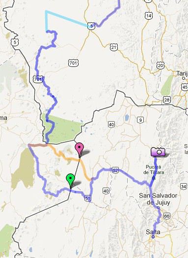
Quand on est en haut du sud Lipez à la frontière Bolivie/Chili, on n'est pas au Paso de Jama. Il faut descendre à San Pedro de Atacama pour se faire tamponner le passeport pour ensuite remonter et passer le Paso de Jama pour l'Argentine. De San Pedro on peut aussi rejoindre l'Argentine par le paso Sico (plus sécurisant en cas de mauvais temps) puis depuis le village de Catua, il y a une piste qui permet de joindre Susquès, Purmamarca, Humahuaca (piste qu'on voit très bien sur Google earth).
Je poursuis la conversation ici pour plus de clarté.
Voila on peut voir sur La carte les 2 parcours.
Maintenant passer par le Paso Sico fait tout de même un sacré détour. Ensuite pour profiter des meilleurs paysages, il faut donc remonter jusqu'à Humahuaca encore un bel aller retour.
(peut être je me trompe et que Pucara de Tilcara suffit)
Quand tu débouches sur la route principale (belle route asphaltée) après la frontière Bolivie/Chili, le poste frontière est à une petite trentaine de kilomètres à droite juste avant l'entrée de SPA. C'est de la descente.
Donc, selon l'heure qu'il est et les possibilités physiques, il est tout à fait envisageable d'y aller, de faire ses tampons et de repartir vers la frontière argentine par le paso de Jama...
J'ai fais du vélo mais, en effet, pas à ce stade et c'est pour cela que j'ai parlé des possibilités physiques. 🤪
J'ignore ce que cette personne peut parcourir comme trajet en un jour, d'où elle partira le matin...
La question me semblait surtout porter sur le fait d'avoir à aller au poste frontière du Chili et par où en repartir...
Les plus beaux paysages (époustouflants) se trouvent dans le Paso Sico surtout côté chilien.
D'après les derniers témoignages d'amis qui sont dans les parages, le Paso Sico est même plus impressionnant que le Sud Lipez... et je les rejoins!
A côté du Paso Sico, Humahuaca et Tilcara font pâles figures.
Pour remonter le col jusqu'à l'embranchement du Paso Jama, il faut compter une très grosse journée car ce sont 27 km d'une montée très raide.
Sur ce temps là, tu aurais fait les 100 premiers km ultra plats avec en principe vent 3/4 dos en direction de Paso Sico.
La capacité à pédaler nous l'avons.
Ce que je sais pour l'avoir lu de droite et de gauche, c'est que de San Pedro ça grimpe fort. Vaut mieux donc assurer tranquille surtout bien chargés.
Désolé si la question vous a semblée porter sur le fait d'aller au post frontière mais la question primordiale serait plus celle du bon "meilleur" chemin pour ne rien rater.
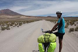
Nous souhaitons traverser le Sud Lipez à vélo, je sais que c'est pas facile, que du sable et de la piste en altitude mais le faire en 4x4 serait pour moi décevant pour vraiment apprécier l'endroit dans son jus.
Ensuite ce que je cherche c'est à ne pas rater les plus beaux endroits de la La Quebrada de Humahuaca.
Mais peut être que de remonter jusqu'à Maimara ou Pucara de Tilca suffit a s'en mettre plein les yeux.
Mais effectivement le Paso Sico à l'air très sympa aussi. De là a dire que La Quebrada de Humahuaca fait pâle figure... vue d'internet je ne dirais pas ça. C'est différent mais les 2 valent le coup.
je ne peux pas te répondre concernant les choses à ne pas rater car on n'y va que cet été. Par contre concernant le Sud Lipez, même si il est impressionnant, c'est pas forcément si dur que ça. Mon beau-frère et ma belle-soeur l'ont traversé (sud-nord) il y a 2 ans, en 8 jours avec un tandem, et ça c'est super bien passé. Ils ont rencontrés d'autre cyclo qui ont fait le détour soit-disant plus facile, mais mis à part le fait que c'est moins un no men's land et qu'il y a moins besoin d'autonomie, la route était très dure aussi.
Si cela peut t'aider, j'ai dans mon natel un fichier .KML intéressant qui donne un tracé et surtout quelques abris pour la tente et point d'eau, je te le transmet si ça peut te servir !
Merci pour ce lien.
Nous nous ne partos qu'en mai 2014 et on devrait être sur le Lipez qu'en fin octobre/debut novembre 2014. donc si d'ici là tu as des coordonnées GPs sur le terrain...😉
Je viens d'importer tes fichiers dans Google Map, ça semble bien suivre ce que nous souhaitons faire... super!
Moi j'ai trouvé ce document pour le Sud Lipez très bien fait.
Ah ben oui, je viens de me rendre compte que j'avais le même document que toi dans mon dossier 🙂 !
c'est impressionnant le job il est vraiment bien fait !!
Notre idée sera de mettre à jours toutes ces infos sur notre site demain est encore loin au retour pour aider de futurs cyclos à élaborer leurs projets, mais c'est vrai que autonomie des batteries oblige, je n'enregistrerai pas le tracé en temps réel avec mon GPS en y passant, mais on le corrigera de mémoire mais à chaud. D'ici là peut-être qu'on pourra te donner d'autres infos plus précises !! Mais tu en sais déjà un paquet sur ton itinéraire pour dire que tu pars dans une année, on part dans 10 jours et on en sait pas autant 😉 !
De San pedro de Atacama, pour rejoindre de nouveau la haute altitude, c'est pas 30 bornes de montée, c'est une cinquantaine et plus de 2000 m de positif. Le vent... Il est à mon avis impensable de faire San Pedro- Paso de Jama en une seule journée. J'y suis passée il y a quelques mois, je venais du sud Lipez que nous avons enquillé même depuis Sajama, après avoir traversé Coipasa et Uyuni.
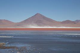
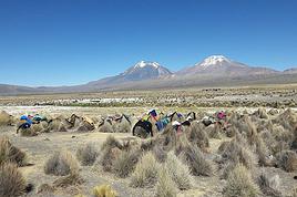
Sud Lipez, c'est difficile à cause du sable, de la caillasse, de la tôle ondulée, du vent. Le terrain lui-même ne présente guère de difficultés, mais sur les 50 000 kilomètres que j'ai fait à vélo dont 45000 en Asie, le sud Lipez fait partie des plus sérieux parce que tu passes autant de temps à pousser et sortir le vélo du sable qu'à pédaler. Et ensuite, tu te bats sevère pour monter ta tente dans la tempète. Un après midi : 8 km. Une matinée : 11. Un autre coup, 2 heures pour faire 4 bornes et sur certains tronçons, quand tu fais cinquante bornes dans la journée, c'est presqu'un exploit. Eau tous les deux jours. Il y en a à Laguna Helionda, laguna Colorada, San Juan, et Chiguana, Laguna blanca au pied du Licancabur.
La route San Pedro à Paso de Jama est en excellent état, velours, c'est beau et désert, pas de circulation. Je ne connais pas Paso de Sico. De la fin du sud Lipez, quand on retrouve le macadam, jusqu'à San Pedro, il y a 42 bornes.
Pour plus de détails, voir le site www.migrationsenbent.fr aller dans carnets de route, puis sélectionner Bolivie, ou Chili selon le cas.
Biensur que tout vécu aide pour les autres qui suivront vos pas.
J'avais déjà lu que ce n'est pas un chemin facile que cette traverser à vélo du sud Lipez...
Mais avec le recule finalement, la referiez vous dans les même conditions, cette traversée?
La nuit vu l'altitude et la saison il fait très froid, mais la journée quelle genre de température avez vous eu?
Merci encore j'ai pris plaisir à lire votre récit...
Bien sur je suis contente de l'avoir fait mais même en 50 000 km en Asie, je n'ai jamais eu des pistes si mauvaises. Alors bien sur une fois que c'est fait et que tout s'est finalement bien passé ben on se dit que ça valait le coup mais c'était tout de même la première fois que je me demandais ce que je foutais là avec un vélo.
Je ne regrette rien, je reste persuadée que j'en ai beaucoup plus profité que ceux qui font le trajet en 4 x 4 en deux jours. Au moins j'ai eu le temps d'apprécier le paysage. Un des trucs les plus durs que j'aie fait, à cause seulement de l'état de la piste.
Au niveau température, entre - 5 et - 10 la nuit, et le jour il faisait bon jusqu'à ce que le vent se lève. On pédalait avec le coupe vent, en pantalon bien sûr mais la plupart du temps sans gant. Faut dire que quand tu pousses et que t'arraches le vélo du sable, tu dégages des calories !
C'est toujours bon a savoir.
Alors après analyse dès que le vent se lève je file tous les bagages à ma chérie car avec ses 42 kg elle pourra faire face au vent. 😏
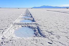
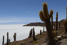
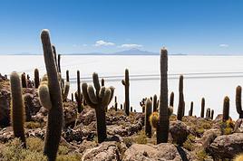
Avec mon amie, on vient de terminer dans l'ordre le Paso Sico; le Sud Lipez et le salar d'Uyuni comme cerise sur le gâteau. Si vous voulez quelques informations et que vous avez un peu de temps pour la lecture, passez voir les articles sur notre blog.
Je ne pense pas qu'il soit possible de faire la côte de 27km de San Pedro vers Paso Jama en une journée. Après cinq mois de vélo on a eu le temps de se faire la cuisse, mais là c'est vraiment très dur.
On est toujours en vadrouille, alors si la réponse à une question tarde un peu, pardonnez-nous... 🙂
Il ne faut pas écouter ce que dit Ecbasis (Jérôme et Cindy) car en fait, je les connais très bien, et ils mentent en permanence sur leur blog car ils font toute la traversée de l'Amérique du sud en stop en 4x4 ou en bus.
😏😏😏😏😏😏😏😏😏😏😏😏😏😏😏
Non hein ! Faut pas croire tout ce que je raconte !!!!!!!!!!!!!
N'hésitez surtout pas à visiter leur blog car pour un premier long périple à vélo, franchement, je suis bluffé. Vous allez vous régaler !
D'avoir enchaîné Paso Sico et Sud Lipez dans la foulée, franchement cela m'épate !
Juste pour preciser, et j'ai vu cette fausse remarque dans deja au moins 2 posts:
Lorsqu'on sort du sud lipez, on se fait tamponner "sortie Bolivie" dans le cabanon bolivien (ne pas oublier de l'eau au refugio laguna blanca). Jusque là tout va bien, puis qques kilomètres jusqu'à la croisée (5-6 kms).
Là, asphalte tout beau tout lisse, à gauche (est) -> Paso Jama et frontière argentine ou a droite (ouest et descente) San Pedro et frontiere chilienne.
Les carabineros chiliens croises a la jonction ds un pick up m'ont certifie que je n'avais pas besoin de tampons entree-sortie chiliens avant de remonter au Paso Jama. On avait donc pedale directement sur le Paso Jama, et là, on te tamponne "entree Argentine" et fini, sans histoires!
Pas besoin de faire l'aller retour entre la croisee et San Pedro pour les interesses!
Par contre, c'est clair que pour aller au PAso Sico, il faut se faire tamponner entree-sortie chili a San Pedro avant de continuer...
Pour le Sud Lipez, il faut bcp pousser suivant l'etat de la route, chaque annee est differente, mieux vaut ne pas insiter a pedaler et pousser trankilos son velo, on perd moins d'energie et ses nerfs...Le seul truc qui m'a royalement fait ch..., ce sont les 125 Jeeps de touristes qui roulent et te depassent a 80 km/h, te projectant du sable et des gravillons plein la gueule (plus les blaireaux qui te prennent en photo depuis la Jeep, ok ils sont frustres et ils nous admirent :-) mais quand meme !!!). Par contre, autant profiter a son avantage, porter moins d'eau et stopper une Jeep de temps a autre pour demander qques litres d'eau, voir une biere pour le soir :-) Un jeune cyclo s'est fait shoote par un vehicule a la Laguna Chalviri et y est decede, ce que je ne souhaite a personne. Soyez prudent!
Petite parenthèse qui n'a rien à voir avec le sujet :
Cyclocosmos a raison Ecbasis, votre blog est vraiment super génial à lire, et votre voyage qui l'alimente doit être vraiment génial aussi ! Bravo à vous 2 !!! Je viens de passer 3 heures à vous lire, j'ai adoré. Mais là faut que je retourne à mes sacoches, on prend l'avion dans 5 jours pour Quito, peut-être qu'on se croisera dans quelques semaines entre l'Equateur et le Pérou !!!
Ho ho ho (façon "Père Noël" le Ho ho ho)... Merci Simouns.
Haaaa, le stress de la semaine avant le départ... Moi j'ai beaucoup aimé ce moment-là. Profitez bien de la famille et des amis pendant cette semaine, c'est plus important que d'avoir les sacoches bien rangées!
Et les cyclos finissent toujours par se croiser, même s'il faut à l'occasion forcer le destin. Se sera avec plaisir 😄
Je suis en train de travailler sur mon prochain voyage en Amérique du Sud à vélo de Santiago à Arica, via l'Argentine passage Chili puis Bolivie. J'essaie de…
Tout est dans le titre. Est-ce que quelqu’un y est passé récemment et peut me dire ou en est l'eau dans le coin? C'est pour passé en vélo dans les prochaines…
Nous sommes un couple de 56 et 64 ans. Nous avons rejoint avec nos vélos cet été pour 5 semaines notre fille et son copain, partis de France depuis 18 mois et…
Je cherche à partir faire un tour en vélo en amérique latine vers la fin juillet 2011. Je souhaiterais notamment faire la traversée du désert d'atacama et du…
I’m planning to cycle from Morlaix to Brest (via Roscoff and the V45 coastal route). We’ll start riding on August 16th for 13 days (with stops for island visits, surfing, etc.). Is there a lot of traffic at this time of year? I’ve got two kids, 11 and 13, and we don’t like riding in the middle of cars (we’ve already done the Vélomaritime—Caen to Cherbourg—the Loire route from Orléans to Saumur, the Vélodyssée from Nantes to Royans, and the canals like the Nivernais and Bourgogne, where there were plenty of bike-only lanes, which isn’t the case on this route).
Thanks for your help if you’ve already done this route in late August!
Virginie
I’ve got my flight ticket sorted—departing in mid-November and returning in mid-March. I’ll arrive in Santiago and leave from Buenos Aires.
I’ve already been to southern Argentina, specifically Torres del Paine National Park, and I’d love to go back to do the full W trek (I only did the shorter version last time).
I also want to do some hiking and maybe even tackle a summit. I climb and occasionally do some mountaineering, so I’ll definitely be going with a guide.
I plan to start around Temuco in Chile, with the idea of heading toward the lakes, then taking the Carretera Austral.
I’m not sure if I’ll go all the way to Ushuaia—it’s supposed to not be *that* worth it, except for the bragging rights of saying you’ve been to the end of the world.
I saw there are lakes in Argentina too.
I don’t have a precise itinerary, but what I’d love is, once I reach the southernmost point of my trip, to take a mini-cruise to see some wildlife. Any tips for that?
What kind of sleeping bag did you take? Is a 0°C (32°F) one enough?
And one last question: white gas stove or can I get by with my gas stove?
This summer, we’re planning to cycle along the EV 19 that follows the Meuse River from Langres all the way to Rotterdam.
My question is about getting back to Nantes.
Do any of you know what the best return option might be? I’d love to hear about your experiences.
I saw that FlixBus doesn’t take bikes.
By train, I think it’s possible but would involve multiple local trains.
We were also wondering if there’s a boat from Rotterdam to Saint-Nazaire that could take passengers with bikes.
Any tips or experiences you can share would be really helpful—thanks in advance!
Have a great evening
Hi there,
I’ve been road cycling for several years, and I’m about to switch to gravel in the next few days—I’m waiting for my bike, which should arrive this week.
I’m planning a bikepacking trip in a few weeks along the Véloroute V81, also known as the Vélosud, from Biarritz to Le Barcarès.
Has anyone here already done this route? Any info is welcome, whether it’s about the route itself, gear, or accommodation. I’ll prioritize staying with locals as much as possible. On that note, I just signed up for the brand-new site *Guidon et Couette* ((www.guidon-et-couette.fr)), which offers free accommodation between cyclists across the country, but there’s almost no one listed along my route!
Thanks in advance.
Laurent.
I’m planning to build a new touring bike.
I want to prioritize lightness.
That said, I’m tempted by a suspension fork that could offer some comfort on rougher roads.
The recent appearance of gravel suspension forks on the market might meet my needs—at least on paper.
I’m particularly considering the RockShox Rudy Ultimate XPLR fork.
Unlike MTB forks, its travel is short: either 30 mm or 40 mm.
It weighs 1400 g, which is 400/500 g more than a steel fork.
Any thoughts or real-world feedback on this?
I’m also wondering about the durability of magnesium (lower leg) for long-distance bike touring.
And what’s the impact of skipping the manufacturer-recommended maintenance every 50 and 200 hours? That’s bound to happen on a long trip unless you carry extra gear.
More generally, how reliable are these kinds of forks?
Hi everyone,
I wanted to share with you the incredible feat my friend José, who’s 72 years old, is currently undertaking. He left Auterive near Toulouse on Monday, May 18, 2026, on his non-electric bike, heading for the North Cape in Norway!
You can follow his route on the link below—he’s currently in Sweden:
https://thierry-thomas.travelmap.net/jose-de-toulouse-a-nord-cap-2026
You can zoom in on the map and click on each stopover town to see the photos
I’m making an exception and creating a separate post this time, since it’s all about France. In May, we spent a week in Provence, specifically in the Luberon, exploring the cycling routes *Autour du Luberon à Vélo*, the *Véloroute du Calavon* (part of EuroVelo 8), and the shorter *Les Ocres à Vélo* route. Together, they gave us an amazing journey through rolling hills, vineyards, lavender fields still green in spring, and some of the most stunning landscapes in southern France.
It was, of course, the perched villages that impressed us the most. We visited Gordes, Roussillon, Bonnieux, Lacoste, Lourmarin, Ménerbes, Oppède-le-Vieux, Cucuron, and Lauris. Many of them are among the most beautiful villages in Provence, and it’s hard not to agree with that reputation.
One interesting point is the route of EuroVelo 8 in this part of the region. The official path mainly follows the old railway line of the *Véloroute du Calavon*, which is very comfortable and safe. But in our opinion, cyclists traveling EuroVelo 8 around the Mediterranean would discover even more treasures if the route passed through villages like Bonnieux, Lacoste, or Oppède-le-Vieux.
We were also pleasantly surprised by how safe cycling felt. Most of the route takes small local roads, but traffic is light, drivers are respectful, and road design really takes cyclists into account. It’s one of those places where you can ride peacefully even without separated bike lanes.
Our full story:
Around Luberon by bicycle - the most beautiful villages of Provence
You can also find all our cycling travel stories on the forum:
Cycling Thread - Europe’s most beautiful bike routes
Hi there, we’re a group of 4 cyclists looking to get from Treviso in Italy to Munich with our 4 non-folding bikes. It seems complicated! Are there any solutions? Thanks so much.
hello fellow cycling enthusiasts
here’s a travel journal of the cycling tour through the Rhône-Alpes Auvergne region by Claudio
zouli
it was the plan
http://cbandiera.free.fr/parcours/auvergne-Ralpes/
the trip was completed
story being posted online soon
1100 km in 11 days
beautiful and varied regions
Hi there, we’re planning a Munich to Venice bike trip at the end of June 2026. Getting back from Venice to Toulouse by train with 4 bikes isn’t straightforward. What return options have others who’ve done this trip chosen? Any tips or great deals would be much appreciated. Thanks a bunch! !
Hi everyone,
Happy owner of a Pegasus Estremo bike with a Rohloff hub, which is giving me trouble with the SF11-NCX-FT-E-LITE 700C TS 300/0 fork (serial number TD01329060). It’s starting to show its age, and I’d like to repair it to extend the life of my beloved bike.
The suspension is gone, and there’s an oil leak from the seals.
Does anyone know how to repair it? Where can I find parts that are about fifteen years old? Or where to find an identical replacement fork? Just to clarify, the Magura HS11 brakes are mounted using Firm Tech, meaning they’re on pivots behind the fork, facing the frame.
Hi, I'd like to know if anyone has done this route recently or has reliable info.
Does the track exist, and most importantly, is there sand (for biking)?
Any info is welcome.
Cheers,
diego ambilobe: mangaoka, manondro, ramena
vohemar sambava: masondrono, tanambao
Hi there,
New to bike touring,
I’d love to start with a section of the Via Rhona to explore and share (route to be decided).
Looking forward to exchanging tips!
I’m landing in Madagascar with a buddy before the end of April 2026. We’re planning to bike around for about twenty days or so. We don’t have a specific goal other than exploring the country and meeting the locals.
Ideally, we’d prefer a loop route starting from Antananarivo with a good chunk of it along the coast. On the bike side, we’re used to riding 6 to 8 hours a day, depending on the needs, encounters, and mood 😉 Any feedback or tips from trips around this length?
A big thank you to Lazarou for all the info you share in this forum!
I'm passionate about Morocco, which I cycled through back in 2009.
Last year, my wife and I explored the High Atlas by tandem. Completely smitten, we're heading back in April (Anti Atlas) and May (High and Middle Atlas), still on our tandem.
Do you have any info on the track between Amezri and Ali Ait Nito? Are the river crossings in the Tessaout still there? It's not easy to navigate with a loaded tandem... especially if the river level is high due to this year's heavy snowmelt!
Thanks in advance for any tips you might have, and best wishes for health in this new year!
Claudio specializes in the route of the Savoie lakes
Here are his travels
Between Bornes, Chartreuse, the Savoie foothills, and Dauphiné
Five lakes: Léman, Annecy, Paladru, Aiguebelette, Bourget, not to mention a few ponds along the way
Plenty of accommodation options: camping, hotels, and more...
A lovely route not far from his place
Rural and quite peaceful
A road cycling route created by Serge B...
Tout d'abord... bonne année ! De belles routes à vous en 2017 !
Je voyage depuis quelques années avec un VTT de très bonne qualité mais équipé de freins à disques hydrauliques. Je vis (pédale) avec l'inquiétude d'avoir une panne (fuite, bulle d'air, chaleur qui fait que le liquide...). Mon vélociste me dit qu'il est impossible de les changer pour des V brakes.
Qu'en pensez-vous ? Est-ce que je prends un gros risque à continuer (seule) avec ces freins ? D'avance je vous remercie pour vos bonnes idées.
First post here to share a quick recap of our west-to-east bike trip along Algeria’s coast in January 2025.
It was just the two of us—my partner and I—with French passports and not a word of Arabic. No friends or welcoming hosts in the country.
Under those conditions, we’d strongly advise against going.
Our original plan was to follow the coast from Algiers to Tunis. We ended up cycling from Algiers to Béjaia, then took the train from Béjaia to Annaba (with a stop in Constantine), and finally biked to the border.
We were tailed by police the whole way—whether on our bikes, on the train, or even on foot while exploring towns. On top of that, we couldn’t wild camp and were limited to the few state-approved hotels that accept foreigners. Under those circumstances, connecting with locals was especially tough.
With such an omnipresent and intrusive police presence, we’d definitely recommend against this destination for bike touring. A really sad situation that completely cuts you off from the local population...
We’d been warned, we went to check it out, and we weren’t disappointed!
Hi there,
I’m planning the route to cycle from Lille to Nordkapp with my partner.
Duration: 3 months, from May 1st to July 31st, 2026.
In the attached details below, I need to add some "non-riding" days (rest days, basically).
So I’m looking to "shorten" the trip by taking ferries or trains for some stretches. Which areas could I skip?
Thanks in advance for your great tips.
Have a good evening.
https://www.komoot.com/fr-fr/collection/4023980/-lille-cap-nord-1er-mai-au-31-juillet-2026?ref=collection
I’m planning to bike back from Poland this summer. Does anyone know a way to ship it there without having to take it apart? Otherwise, it’s a real hassle to fine-tune all the settings before departure!
Thanks in advance.
Hi, has anyone recently bought Primus or Butagaz gas, possibly puncture-style, in Dubrovnik or the surrounding area? Same question for Albania... thanks. aichatou
Just a few words about the loop I did by bike in Yunnan.
Entry and exit
I entered China through the Sino-Vietnamese border crossing at Lào Cai / Hekou under the 30-day visa exemption currently available to French nationals and others.
The process was simple and quick. A Chinese police officer even helped me complete my electronic pre-registration at a computer kiosk. I wasn’t aware this formality was required—it’s similar to Thailand’s TM6.
No issues with the bike.
I left the country via the Sino-Laotian border crossing at Mohan / Boten.
The atmosphere was a bit chaotic there, but again, no problems with the bike.
The timing
I visited Yunnan in February 2026.
Weather-wise, at higher altitudes (between 1,500 and 2,000 meters), it was around ten degrees at night and in the mornings, and around twenty degrees at the hottest part of the day.
I had two days of rain, so I took the bus to keep moving. Otherwise, clear blue skies.
Culturally, Chinese New Year fell on February 17th (and the 15 days following), right in the middle of my trip. Because of this, my take on the traffic might be off.
Accommodation and food
I always found a hotel to stay in for prices ranging from 8 to 15 €. Except in Kunming (the capital), where many hotels were fully booked (Chinese New Year). I ended up at a 100 € hotel with great value for money.
A bowl of noodles costs about 1.5 € on average.
Onboard electronics
Since my smartphone doesn’t support eSIMs, I subscribed to a China plan with my carrier. Otherwise, for much cheaper, Alipay offers eSIMs for foreigners that allow access to services usually blocked for Chinese users (WhatsApp, Facebook, etc.).
An internet connection is essential for paying with Alipay or WeChat, as this payment method is widespread.
I only managed to use Alipay.
Either way, always carry cash because sometimes there’s no signal, or the merchant only accepts WeChat.
Also, it’s best to bring a power adapter when you arrive rather than struggling to find one.
Traffic and roads
The Chinese aren’t reckless drivers. They follow traffic rules and watch out for cyclists. This is slightly less true in Xishuangbanna (the region bordering Myanmar and Laos).
In urban areas, there are almost always wide bike lanes, separated from other roads, where bikes, electric mini-scooters, and scooters share the space pretty harmoniously.
The roads are in great condition, and traffic is generally manageable—even light—except for one stretch (Eshan -> Yangwu).
Most traffic is absorbed by expressways, China’s equivalent of highways: toll roads that are off-limits to slow vehicles.
You’re never far from these expressways; sometimes you even ride alongside them, which can be noisy at times.
The climbs are usually reasonable, around 5% to 6%. From what I remember, the steepest section was between Menglun and Mengla, with gradients of 8% to 10%, sometimes more.
Riding at these altitudes—though modest—took a bit of getting used to.
The route
I didn’t plan anything in advance. My only goal was to reach Kunming. I don’t know why, but just hearing the name of that city, like Yunnan, always felt dreamy to me.
Hi! I’m planning to visit the Stockholm Archipelago by bike in early April.
Do you know if the boats will be running between the different islands at that time of year? For those who’ve already been, all your tips and recommendations are welcome—accommodation, etc. Also, do you know where I can rent a bike in Stockholm? Thanks so much in advance for your help!
Hello there, pedal-powered Young Boys!
Claudio (still from Faverges)
dreaming about a cycling getaway in Italy from Faverges (train all the way to Turin)
from Turin down to Venice along the Po River and back via the Padana (Alta Italia da attraversare – Northern Italy to cross)
The tricky part is getting from Chioggia to Venice.
I read it’s possible by hopping on a boat from island to island,
but it sounds a bit stressful.
Has anyone already tackled this route?
I’m currently looking for a bike to do my first bike trip across France, with the ultimate goal of cycling through Latin America. I’ve got a lot of questions and I’d love to hear if you have any answers or advice to share.
First off, I’ve been through this before with hiking. I want to get top-quality gear right away. When I started hiking, I ended up buying everything three times—first beginner gear, then intermediate, then expert, etc.
For biking, I’d prefer to skip that process and invest right now in a bike that could ideally handle Latin America.
I’ve set a total max budget of around 5000 € (roughly 4000–4500 € for the bike and the rest for accessories: panniers, helmet, cycling shorts, etc.).
So, I’ve got quite a few questions:
* I’ve read in several places that some people recommend buying the bike directly in Latin America. Since I need a first bike to train in Europe, would it be better to buy an entry-level bike in France (and sell it before the big departure)? Or is it preferable to start right away with my final bike to get used to it? Is buying it there just to save a bit of money?
* For a long-term trip (around six months) in Latin America, is it better to go for a gravel bike or a mountain bike?
* Should I buy a new bike or a refurbished one? Even more so given that I’m planning a long trip—could a refurbished bike end up causing more breakdowns?
If you have any advice on models, technical features to prioritize, or recommended sellers or resellers, I’d love to hear it. I’m a total beginner—I’ve only just started watching videos and reading up on the subject, and all the technical specs are new to me!
Calling all travelers.
We’ll be landing at Lyon Airport and want to bike to La Verpillière train station (with panniers and camping gear, etc.) to catch a TER to Voreppe.
What’s the safest route for this bike trip?
Thanks in advance
hi,
I'm planning a recumbent bike trip from the Pyrenees to Greece. On the EuroVelo 8 route, it doesn't specify the path through the Alps.
Are there any experienced cyclists here who can tell me where they go to avoid climbing too high?
Also, is there another traveler/bike forum better suited for broadening the responses?
thanks