Bonjour, je pars pour l'Alaska du 8 au 25 mai. Est-ce que quelqu'un a déjà emprunté la trail du Mont Juneau (Juneau Mount Trail?). J'ai lu sur quelques sites web qu'il s'agit d'une randonnée très difficile, abrupte et qu'il faut faire attention aux avalanches / glissements de terrain. Croyez-vous qu'aux alentours du 17 mai cette trial est praticable?
Sinon, je cherche un moyen de voir des glaciers à partir de Juneau pour pas cher (je ne veux pas prendre l'hélicoptère). Avez-vous des suggestions?
Merci beaucoup Etrefal. Sinon, aurais-tu des incontournables à me recommander, que ce soit à Juneau, Sitka, Haines, Skagway, Ketchikan? J'aime les paysages insolites, la nature, la randonnée (je n'ai pas peur de marcher toute une journée, mais je n'aurai pas d'équipement de camping avec moi, je dors toujours dans les Hostels). Cela vaudrait-il la peine d'aller à Gustavus pour voir Glacier Bay?
Est-ce que quelqu'un a déjà emprunté la trail du Mont Juneau (Juneau Mount Trail?). J'ai lu sur quelques sites web qu'il s'agit d'une randonnée très difficile
Je n'ai pas fait cette rando qui est une extension de "perseverance trail", mais cela ne m'empêche pas d'en parler 😉.
Probablement tu dois trouver via internet le livre-guide dont je parle sur les balades autour de Juneau (Juneau Trails).
Sinon, je cherche un moyen de voir des glaciers à partir de Juneau pour pas cher (je ne veux pas prendre l'hélicoptère). Avez-vous des suggestions?
Cela tombe bien, je peux te conseiller un excellent ( ???? 😊) carnet de voyage.
Voir ICI.
....Et les quelques messages suivants, relatant les 3 ou 4 jours que j'ai passés autour de Juneau.
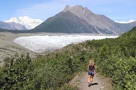
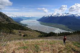
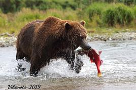
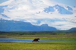
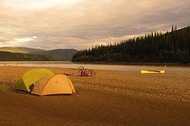
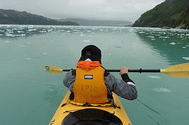
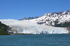
Tu y trouveras quelques infos sur les balades autour du Glacier Mendenhall (attention aux ours 😏), mais surtout la sortie à la journée en bateau vers Tracy Arm et ses deux magnifiques glaciers. Je ne peux que te la recommander.
3.14
De l'Alaska à l'Arizona : contrastes. Voir https://voyageforum.com/v.f?post=4396533#4396533
Dans la vie, le pire qui pourrait nous arriver serait qu'il ne nous arrive rien !
Sitka: Centre de réhab des oiseaux de proie, la coupole russe, rando le long de la rivière Indian jusqu'aux chutes.
Haines: Musée des outils, musée Sheldon, beaucoup de rando (Battery Point, Ripinski, Mont Riley)
Skagway: Prendre le train jusqu'au sommet, visite à Dyea et mini-bus, sentiers des lacs Dewey, bureau des parcs nationaux (Chilkoot), rivière et lac Chilkoot 12 km du village.
Glacier Bay: les visites en bateau partent de Juneau 😉
Merci beaucoup Trois14, je vais étudier tout ton carnet attentivement! Je suis certain que cela saura m'inspirer. Saurais-tu me dire si, pour cette période de l'année (mois de mai), il serait préférable que je réserve d'avance mes excursions, ou si je peux attendre d'être sur place afin de pouvoir négocier et comparer les prix?
Encore merci pour ta réponse rapide! Battery Point, Ripinsky et Mount Riley étaient déjà sur mon itinéraire!
Skagway semble tout près de Haines, est-ce qu'il y a un autre moyen de rejoindre Skagway (à partir de Haines) que le ferry (31$)? Un bus peut-être? J'imagine qu'il est trop tôt en mai pour tenter la Chilkoot Trail?
À Sitka j'avais prévu emprunter la Harbor Mountain / Gavan Hill trail, as-tu un opinion sur celle-ci? (Peut-être est-ce celle dont tu parles qui longe la rivière Indian)
Dernière chose... Étant donné l'horaire des ferrys, je devrais passer 4 nuits à Sitka, cela me semble beaucoup, y a-t-il de quoi s'occuper durant 3 journées entières?
Je ne connais pas la fréquentation de Juneau en mai, mais je ne pense pas que ce soit aussi tendu qu'en Juillet.
Pour ce qui me concerne, j'avais réservé la croisière à Tracy Arm avec "Adventure Bound Alaska" depuis la France 2 ou 3 mois avant, par internet, puis par téléphone pour négocier. Et cela avait marché (on a eu une réduc car nous étions tous les deux seniors).
Et sur la vedette, nous étions complets.
Bonne préparation
3.14
De l'Alaska à l'Arizona : contrastes. Voir https://voyageforum.com/v.f?post=4396533#4396533
Dans la vie, le pire qui pourrait nous arriver serait qu'il ne nous arrive rien !
Malheusement, de Haines à Skagway par la route c'est 600km 🤪 Les premiers 25 km de la Chilkoot devraient être dégagés mais boueux. Indian River Trail est la seule que j'ai fait à Sitka et 4 jours là serait trop long pour mon style de voyage mais si tu fais du kayak et du VTT, c'est une autre histoire
Malheusement, de Haines à Skagway par la route c'est 600km
Mais en ferry de l'AMHS (au moins un par jour, le matin), c'est un heure seulement. Coût 80$, pour 2 personnes et une voiture.
Pour Sitka (voir mon carnet de voyage, référence en fin de message), nous n'y sommes restés que peu de temps, et avec de la pluie. Nous n'avons pas randonné.
Mais je trouve aussi que 4 jours ce doit être bien long (ceux qui y vivent, ou au moins connaissent bien, ne pensent probablement pas la même chose).
3.14
De l'Alaska à l'Arizona : contrastes. Voir https://voyageforum.com/v.f?post=4396533#4396533
Dans la vie, le pire qui pourrait nous arriver serait qu'il ne nous arrive rien !
Lis http://voyageforum.com/v.f?post=3446658; pour mon experience dans cette region, j'y etais en mai. Si tu as des questions j'y repondrai apres que tu l'aies lu.
Bonjour Willemspie, j'ai effectivement lu ton carnet il y a quelque temps déjà et je m'en suis inspiré. Je suis en quête comme toi de nature et de tranquillité, mais je ne ferai pas de camping car je n'ai aucune expérience en région sauvage et je juge plus prudent de demeurer dans les Hostels.
Donc voici mon planning :
Arrivée à Ketchikan par avion le 8 mai à 15h57
3 nuits au Eagle View Hostel, Ketchikan
Ferry Ketchikan - Sitka le 11 mai, arrivée à Sitka le 12 mai à 15h30
4 nuits au Sitka International Hostel, Sitka
Ferry Sitka - Juneau le 16 mai, arrivée à Juneau le 16 mai à 19h45
4 nuits au Juneau Hostel, Juneau
Ferry Juneau - Haines le 20 mai, arrivée à Haines le 20 mai à 10h45
3 nuits au Bear Creek Cabins and Hostel, Haines
Ferry Haines - Ketchikan le 23 mai, arrivée à Ketchikan le 24 mai à 19h45
1 nuit au Eagle View Hostel, Ketchikan
Départ de Ketchikan par avion le 25 mai à 17h45
Ça semble réglé au quart de tour, mais j'ai écrit les heures juste pour donner une idée du temps que je passerai dans chaque région. Selon toi, est-ce que je manque quelque chose d'incontournable? Est-ce que je passe trop de temps quelque part? J'imagine que cela dépend de mes intérêts et de ce que je prévois faire.
À Ketchikan, Deer Mountain and Silvas Lake Trail, pêche au saumon sur un charter, Misty Fjords National Monument en hydravion, Orcas Cove trip en kayak
À Sitka : là je manque d'idées un peu... Harbor Mountain / Gavan Hill trail
À Juneau : Perseverance trail, Tracy Arm fjord en bateau, rando vers Mendenhall Glacier
À Haines : Battery Point trail, Mount Riley trail, Mount Ripinsky trail
Je ne connais pas les horaires de bateau, mais moi je resterais moins de temps a Ketchikan et surtout a Sitka et j'irais certainement a Skagway. En plus de l'Alaska Ferry, il y a aussi un bateau local entre Skagway et Haines.
Le problème pour Skagway est que je n'ai pas trouvé d'hébergement mis à part les motels à 100$ et plus la nuit... Il y avait un hostel autrefois mais il est fermé cet été. Je songe à laisser tomber Sitka, les horaires du ferry sont vraiment compliqués. Pour Ketchikan je peux facilement laisser tomber un jour ou deux.
Aussi il y avait encore beaucoup de neige des 500 metres (meme peut etre moins) en mai 2010. Par ex si tu veux monter au Mont Ripinski. Tu dois etre equippee pour.
Tous les hotels/motels en Alaska (sauf a Anchorage) sont a 100$ la nuit. J'ai sejourne 2 nuits a la YH de Sitka. Sinon dans cette region j'ai campe tout le temps.
J'ajouterai encore que le Mont Juneau, ce n'etait pas possible a cause de la neige en mai 2010. Pour d'autres randos dans la neige, je n'ai reussi que parce qu'il y avait deja des traces.
Bonjour Willemspie, je suis bien équipé en vêtements chauds et imperméables (chandail polar + veste 100% imperméable, pantalon 100% imperméable avec combine chaude, bottes de marche imperméables). J'apporte également mes raquettes et mes bâtons de marche. Je compte emprunter certains sentiers même enneigés. Je compte également aller du côté de la Kruzof Island à l'Ouest de Sitka et y passer une nuit dans la cabine du gouvernement à louer, la trail du Mount Edgecumbe (rando un peu longue pour être faite en une journée considérant le transport par bateau jusqu'à l'île).
Je souhaiterais partir dans le parc Denali fin juin mais j'ai beaucoup de mal à l'organiser bien comme il le faut.. le 26 juin:Je dois faire le vol en avion au…
Nous envisageons un trek en Alaska en juillet 2012. A peine revenu d'Islande, nous organisons un nouveau départ. Quelqu'un connait-il un trek de 5 à 10 jours…
Je suis en train de réunir un max d'infos en vue de traverser l'Alaska à pied, en partant de Barrow jusqu'à Fairbanks. J'ai pas mal de questions, si certains…
Je reviens sur le parc Denali et le fonctionnement des bus. J'ai déjà lu pas mal de choses, notamment sur le forum, mais malgré tout ce n'est pas encore…
Mon conjoint et moi allons voyager 2 mois cet été dans le nord-ouest canadien et américain, dont un mois complet en Alaska et au Yukon (aout 2016). Nous y…
Bonjour,
Nous souhaitons faire le trek de 4 jours reliant Mestia à Ushguli sans agence. Il est précisé dans les descriptifs qu'il existe des hébergement à chaque étape, mais on ne trouve pas d'info sur ces hébergements. Quelqu'un a-t-il des infos et un avis sur ce parcours?
We're planning to trek in Peru and Bolivia and would love to find some local agencies.
If you know any, could you share details on prices and, of course, the names of the agencies?
Which trek would you recommend?
Elocine
Je pars en autonomie totale sur un trek au Maroc (10jrs) Imilchil - Aghbalou.
Trouve t-on des cartouches gaz à vis (Coleman, Primus) à Marrakech (adresse) ou villages entre Imilchil - Aghbalou ?
Si non , trouve-t-on des cartouches Butagaz pour camping-gaz (petit volume 230 gr ...)
Merci d' avance pour vos réponses
Hello, I’d like to embark on a little trip in my home country, Switzerland. I’ll start walking from La Cure, heading toward Le Noirmont first, then I’ll improvise my route—but it’ll probably follow the French border... at least as far as Lac de Joux.
I’ll decide day by day how much farther to go after that. My goal is to stay in nature as much as possible, wander around for as long as I can, and restock food in villages or towns along the way.
I’m thinking of mostly camping, but we’ll see if I end up in a hotel or another campsite depending on my route.
I’d love to reach La Chaux-de-Fonds on foot... maybe even Delémont.
The whole thing should take about a week, give or take.
I’ll be bringing my dog, and I’m preparing for this as soon as I’m ready.
Any tips to make sure everything goes smoothly for us? Things I should know—or avoid? What about shepherds with their flocks of sheep? And isn’t hunting season open right now?
I’m not sure if what I’m planning is even doable, which is why I’m asking around.
This’ll be my first time doing something like this—wandering in nature *and* with a dog. I’m really excited for this adventure... and I need it. Thanks!
We’re really keen on ecosystems and want to hike in "natural" ancient forests—not planted woods or areas heavily degraded by human activity. Travel guides (like Lonely Planet) don’t provide much info on this. Could you point us to the most interesting spots?
Thanks in advance for your tips.
We wish you happy holidays and a fantastic 2026, full of discoveries!
Claire and Albert
Hi, this might not be the right section, but I’d like to know if it’s possible to start mountaineering with another person without necessarily hiring a guide. We’ve done quite a bit of hiking but not mountaineering—we’ll just do a half-day glacier course. After that, we were thinking of starting with La Grande Motte and the Pointe de la Traversière, which were recommended to us. Honestly, for things like roping up and knots, I’ll learn at home with lots of videos and a book.
Hi,
I don’t know Switzerland at all and was wondering if Vallée des Joux and especially Dent de Vaulion are packed early in the morning or late in the afternoon in July and September?
If so, do you have any quieter spots to recommend in the area, or in Luxembourg (yes, I know it’s not the same country 😉)?
Thanks a lot!
I’m starting this thread—lots of travelers here have done this trek.
When RMS is mentioned, it’s this agency: Ruwenzori Mountaineering Services (with an *s*), because there’s another one online called Ruwenzori Mountaineering Service (no *s*).
Their site:
www.rwenzorimountaineeringservices.com/
From what I gather, it’s the local mountain guide agency certified by the government?
Jaimerais savoir si quelqu'un aurait fait des treks sur le Ruwenzori et combien ça coute en moyenne, les infrastructures, les paysages la sécurité sur les lieux, merci beaucoup. J'attends avec impatience vos réponses.
We’re leaving in 9 days for a two-week trip to Madeira, mainly to hike.
From my research, I’ve found that since last year, access to most trails—and systematically for the most popular ones—is now paid. You have to pay an access fee of 4.50 € per person per classified hike in 2026, and even 10.50 € for the most iconic hike: Pico Arieiro to Pico Ruivo. When paying, you also have to choose a day and a 30-minute time slot for your start time. Of course, this reservation is neither changeable nor refundable, even if the weather that day is terrible.
Personally, given the massive influx of tourists to the island in recent years, I don’t mind paying a fee to help maintain the trails. Similarly, setting a limit on the number of people who can hike them per day is certainly preferable to preserve this priceless heritage.
However, what’s much less fair is that in reality, most of the available spots are reserved: 1/ for Madeira residents (which is normal); 2/ for "economic operators" (meaning local tour operators). For example, if you’re a non-resident (independent tourist), no booking is possible for the Pico Arieiro hike for an early morning start before September! So, unfortunately, we’ll have to skip this hike.
It’s the same issue for Ponta de São Lourenço, the 25 Fontes, Pico Ruivo... in short, all the most popular hikes. Oh well, we’ll skip those too!
So my question is: which hikes do you recommend where we won’t face the huge crowds that the others get? And where we can book the day before for the next day, taking the weather into account?
Finally, a quick accommodation question: we’ve booked the first week in Funchal, but I haven’t decided yet for the second week. Do you have any advice on where to stay in the south or north, preferably avoiding overly concrete-heavy and touristy spots?
I’m reposting about the logistics for Samaria Gorge.
I’d love to get recent info, especially about whether it’s possible to park my car in Omalos, do the hike, and then catch a bus back to my vehicle.
In theory, it’s doable, but when you check the KTEL website, there aren’t any feasible schedules listed. If anyone has recently organized this with reliable, verified details, I’d really appreciate it. Thanks in advance!
Hi there,
We’re flying from Montreal to Lyon this August to go hiking in the French Alps. We’ve rented a car and will be staying at campgrounds. We’re planning to do day hikes and want to stay a few days in one spot, do a few hikes, then move on to our next camping spot. Could you share your favorite spots or any recommendations for places to spend a few days with great hikes?
A few details:
We arrive in early August and leave in early September.
We’re looking for day hikes (or shorter), moderate difficulty, with a cumulative elevation gain of no more than 1000m, and of course, beautiful scenery!
We’d prefer not to drive too much—maybe it’s best not to head too far south and deal with unnecessary heat?
Along the same lines, if you know of any great campgrounds where we can start our hike directly without needing the car, we’d love to hear your suggestions!
Bonjour
Souhaitant faire de la randonnée sur cette île, je voudrais d'abord savoir quelle serait la période la plus favorable sachant que j'avais passé quelques jours en novembre 2018 pas pour cette activité mais plus pour une simple découverte de l'île et le temps n'était pas top notamment en montagne. Donc peut on choisir une organisation en étoile sachant que je louerai un véhicule avec éventuellement 2 points d'hébergement.
Je n'envisage pas d'intégrer une structure mais de partir à 2 et de s'organiser sauf si vous me conseillez une agence locale ou un guide local. Enfin même si je compte me procurer les différents supports, carte et topo guide plus gps je vous remercie de bien vouloir me communiquer les randos à faire en priorité
Merci beaucoup pour vos informations
I’m planning to do the Mercantour crossing following the Randoxygène route in mid-July.
I’m used to hiking in the mountains, but I sometimes get vertigo, for example on ridges with drops on both sides. I wanted to check if there are any T4 or T3-T4 sections and find out if there are any very exposed passages—and if so, where—so I can plan an alternative route.
Can anyone give me some info on this?
Thanks!
I’m planning a trip around Cap Corse and the AGRIATES in 2026, from May 8th to 15th (there are still 2 spots left, by the way! Just DM me if you're interested).
I’d love to know which hikes are worth prioritizing in the AGRIATES. We’ll be staying in SALECCIA for two days as our base—what should we focus on from there?
A round trip to IGNHU beach? Any other suggestions?
For Ostricano, I think it’s too far for a round trip...
Thanks for your tips!
Have a great day,
Anie, Toulouse
I’d like to get some info about the GR10 Pyrenees traverse. I need help planning the daily stages and accommodations—my wife isn’t an experienced hiker but walks a lot, so I’d like to schedule shorter walking days and thus a longer overall trip in terms of number of days.
Could anyone give me some help and advice?
Best regards,
New to this forum, I’m planning a pretty big project for 2028.
I’m heading to Nepal to do a trek from Kathmandu all the way to Everest Base Camp (a cool 5,300 m 😄).
This trek is a bit special because even though I’ll be part of a group, I’m going solo (so far, no problem—I’m used to it). But it’s my first real trek, and it’s also a humanitarian one: once I reach base camp, I’ll stay an extra week to help clean up the waste left by tens of thousands of climbers! Since I’m originally from South America, from two countries that share the Andes, I have a deep respect for mountains—they fascinate me. So Everest… it’s kind of the trip of a lifetime!
So, a little question for those who’ve done treks to Everest before… any tips for good mental preparation (I’m already working on the physical side)?
Hi there, I’m planning the Annapurna Circuit for March 2027 and I’m looking for a local agency with a local guide—preferably French-speaking—to arrange this trek for us. Any suggestions? Thanks
Hello!
We’re spending a few days in Toraja country at the end of May. We’d love to do a day trek—taking our time—on a route that’s stunning in terms of scenery, but not a level 5 in difficulty!
Any suggestions you can share, please?
Thanks in advance
I’d like to do the Mare a Mare Sud in May over 4 days. I’ve found quite a few places to stay along the route, but I’m stuck on the start and finish.
I’ll be arriving by plane on Sunday evening and would like to start pretty early on Monday morning. Ideally, accommodation right at the trailhead (Alzu di Gallina) would be amazing, but I can’t find anything. Any tips?
Also, for the transfer from Figari Airport to Porto Vecchio or Alzu di Gallina?
At the end, I’d like to pick up a rental car—any advice on that too?
I’m traveling solo by plane to Catania in May and plan to hike the northern side of Etna, starting from Linguaglossa where I’ll arrive by bus. After that, I’d love some info on how to get up to Piano Provenzana (shuttles or hitchhiking), since it seems there’s no public transport except in the summer. Can you sleep there in a free or cheap refuge, or camp? And how far up can you go without having to hire a guide? Thanks in advance. Bernard.
Bonjour a tous,
je pars en voyage au Maroc en aout et nous allons commencer par nous arrêter a Chefchaouen(nous sommes en voiture).
Ma question: quelqu'un peut il m'indiquer un itinéraire de rando en boucle d'entre 5 et 7 jours aux départ de Chefchaouen dans le parc de Talassemtane passant si possible par le pont de dieux?Ou un guide papier qui en reunis quelques uns?
Nous privilégions le camping sauvage et les gites.
Merci d'avance
Hi there, for those who’ve been recently—is it possible to find other solo travelers in March on the island to share transport or room costs? It doesn’t seem easy to travel on a budget.
If you have any recommendations for simple lodgings or places with dorms, I’d love to hear them.
For those who’ve done multi-day treks while moving around: do you need to bring your own sleeping bag? I’d love to hear about itineraries you’ve done without a guide, just with a map and GPS.
Thanks, and have a great day!
Hi everyone!
We’re planning a 15-day road trip to Scotland this summer, specifically to explore and hike on Lewis and Harris—places we’ve never been before. We’ve visited other islands on previous road trips in Scotland (we usually go in April for a week). This would be our first time in Scotland in the summer and for 15 days. We’re looking at late August to early September.
I’m currently drafting the itinerary. We’d be crossing from Ullapool and were thinking of spending 3 nights on Harris and 4 nights on Lewis.
Does that sound balanced to you? Is it better to keep the same accommodation on Harris and the same on Lewis to explore the area? I’d love to hear about any past experiences you’ve had on these islands.
Thanks!
Hi there, I’m trying to leave for 15 days very soon to São Vicente. I’m either looking to join an agency or figure things out on my own to go hiking on one of these islands or both. From what I’ve seen, it’s not easy to organize with local transport, so it gets expensive. Can I use the services of a small local agency? I’m looking for the simplest way to hike for several days. Also, how do you get from São Vicente to São Nicolau? Thanks in advance and have a great day!
Aichatou
I’ve been wanting to do this for several years, and this year’s the one. Next September, I’ll be trekking in Tusheti (Georgia), from Omalo to Shatili.
Of course, I won’t be renting a vehicle that’d just sit unused. No problem getting to Pshaveli, but from there to Omalo, it’s a dirt road (still the case?)
There must be some form of public transport since there are so many guesthouses, and not all travelers come in a 4x4.
If any of you have been to Omalo, could you confirm that these shared transports exist and how often they run?
we’re planning a trip to Yellowstone and hoping to do a three-day backcountry hike if we get a permit.
if any of you have done this before, could you let me know if it’s possible to find water along the way? And if we can transport it, are we allowed to use a stove?