bonjour
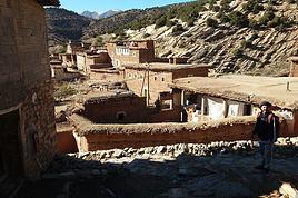
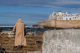
j'envisage de traverser le maroc a pied par l'atlas et le rif
genre agadir-tanger
départ mi -avril
si quelqu'un a déjà fait ca ou un bout j'ai quelques sur le rif?
dans le désordrequel itinéraire avez vous choisi?comment ca été pour le ravito en eau et en bouffe?comment a été l'acceuil des locaux ?quel temps avez vous eut ? pluie? vent? froid?comment avez vous rechargé les batteries de l'appareil photo?comment couchiez vous ? quelle tente et quel duvet (température?)la tente est elle necessaire?avez demandé un peu l'hospitalité?réchaud a gaz ou a essence?quoi savoir avant de partir?quel budget?comment transporter ou récupérer de l'argent ? je supose qu'il y a pas des tirettes a CB derrière chaque pierre
y a beaucoup de ? 🏴☠️
alors si ca te fait chier de répondre a tout
sépare en plusieurs fois
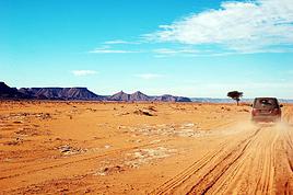
Moi je l'ai traversé en voiture il y a longtemps.
2 choses à dire qui n'ont probablement pas changées depuis, c'est que
1) c'est là que la culture du cannabis est pratiquée (grands champs le long des routes)
2) Les 2 contacts qu'on à eu avec des locaux c'est avec des gens qui voulaient nous vendre du hashish, trés insistants voire agressifs. On avait eu vent à l'époque de trés mauvais plans dans le coin et on ne s'est guère arrêté, mais le sport local était clairement de soutirer de l'argent aux passants.
Si ce n'est plus pareil tant mieux, mais quand on voit des reportages sur le traffic, il a l'air florissant. Le traffic n'est certes pas génant pour le touriste mais la délinquance qui va avec si.
J ai fait le rif il y a 30 ans a velo et a l epoque je n ai pas traine le seul arret hotel que j ai fait il y en avait qui triait du hash et il ne rigolait pas specialement . A pieds je pense que tu vas faire une experience que tu n aimeras pas specialement renseigne toi un peu partout . A mon epoque meme la police n y allait pas c etait un endroit de non droit
Bon courage et regarde sur la carte il y a d autres itineraires plus reposant nerveusement que de passer par le rif
Jean Marc Maryse
Jean-Marc & Maryse
Qui plante un arbre, plante le bonheur (proverbe chinois)
L'atlas oui, le rif NON
Photo: piles
Pas de cartouche de gaz, donc réchaud à essence si vous en avez un
Tente indispensable, duvet assez chaud.
Ne pas quitter la route nationale, mais à pieds c'est fortement déconseillé, le jour à cause du soleil, la nuit à cause du manque de repères
Prendre les grands taxis, à plusieurs, prés des gares routières. (pas cher)
bonjour yulbo
merci pour ta réponse
cependant j'aurai quelques ? a approfondir
tu as traversé l'atlas ? de ou a ou? en combien de temps ? seul ou accompagné ?
penses tu que meme en mai juin juillet il fait encore froid dans les montagnes ?
pourquoi la tente est indispensable ? orage? vent ?
je n'ai pas compris ta dernière phrase sur la route nationale.....?
peux tu developper ?
Sur guide du routard 2007/2008 et sans doutes dans le nouveau, ils parlent longuement du rif et disent que la région a été sécurisée, enfin, apparemment plus de mecs qui se jettent par terre pour arrêter les voitures pour vous vendre un kilo de concentré de plantes locales ! 😏
Aube
Viens donc! Regarde le soleil à son méridien, et de l'autre côté la nuit foule déjà à ses pieds le Maroc. Dante.
ok tinitrane
ca me fait plaisir ce que tu me dis car pour l'instant les réponses a mon message n'étaient pas très réjouissantes 🏴☠️
merci pour l'info 😎
a+
simon
Contacts Hoceine Ahalfi :
Courriel : atlaspassion@yahoo.fr
Les courriels sont les plus pratiques, car il peut ainsi les consulter de tous les endroits où il se trouve au Maroc.
Téléphone sur le terrain quand il est sur réseau : 00.212 (0) 66.59.13.56.
Ce sont les coordonnées d'un ami guide de longue date avec qui j'ai personnellement fait de tres nombreuses reconnaissances (y compris dans le RIF) du Nord au Sud.
Sérieux et fiable je peux le conseiller sans crainte de me tromper et sans arrières pensées commerciales.
De la part de Jean-Claude, il saura d'ou ça vien et n'en sera que plus attentif.
Bonne balade enrichissante, y compris dans le RIF, ou j'etais en Mars 08 sans aucun dérangement.
"Le desert est beau, ne ment pas, il est propre".Th.Monod.
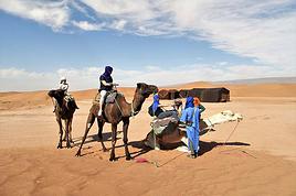
je n'ai pas vraiement d'info à te fournir pour cet itinéraire, cependant je te conseillerai, vu toutes tes questions, dans un premier temps de t'acheter un guide de voyage qui t'indiquera : les hébergements potentiels, les transports locaux...conditions climatiques...et de bonnes cartes du secteur.
Maintenant si tu souhaites réaliser une rando hors des principaux axes routiers, donc plutôt en pleine nature, il te faut être totalement autonome :
Une tente bien sûr la plus légère possible soit max 1 kg, autoportante si possible (type igloo pour plus de résistance au vent)
ou un abri bivouac monoplace en tissus impert-respirant (sorte de petite tente tunnel)
sac de couchage : si tu ne bivouaque pas à plus de 1000m prend un sac donnée pour 0°C ou -2°c (cela dépend aussi de la saison de ton voyage, il fait plutôt bon à la mi-avril)
un bon matelas de sol de rando (autogoflant = grand confort, un poil lourd mais vraiment confort...)
l'eau :
En pleine nature (cours d'eau, lac, source) et proche des villages (puits, fontaine), il te faut filtrer et purifier l'eau, l'idéal, pour l'avoir utiliser régulièrement, est un filtre de poche à pompe de type waterWoks de MRS.
En ville acheter des bouteilles d'eau minérales
la bouffe :
Pas bcp de choix en alimentation légère dans les petits villages : pates, conserves de sardines et thons, soupe lyoph, orange, petit melon, carrote... Ne pas hésiter à acheter de la nourriture en france : pate chinoise, barre de céréale, chocolat, paté...
le réchaud :
On peut trouver des petites bouteilles de gaz pour campingGAz dans certain supermarché
Si tu viens par une autre moyen que l'avion tu peux emporter ton réchaud à Gaz et ses bouteilles, sinon prévoir un réchaud à essence ou même manges froid le midi et fais un feu le soir.
recharger les piles et batteries:
il existe de petits panneaux solaire léger (type e-sun) qui ce déplie en 4 volets format A5 (12v et 600mA, 200 grammes), fournit avec une connection alume cigare et te permettant de recharger des piles-accu en une journée ou demi-journée suivant le capacité des piles. (j'utilise régulièrement ce matériel dans mes treks sahariens)
Argent :
Les villes importantes ont toutes des distributeurs CB, à condition d'avoir une carte visa internationnale.
Budget :
Si tu es autonome, seul la bouffe, les transports (bus, taxi) et hôtel au départ et à l'arrivée, voire les hotels intermédiaires sur la route suivant le temps que tu passes sur le terrain.
Moi je compte grosso modo de 20 à 50 euros la semaine.
Hébergement : les habitants sont souvent accueillant hors des villes au Maroc. Mais je ne connais pas le Rif
Sécurité : trouve un équipier, c'est mieux si tu t'aventures hors des sentiers battus et hors couverture GSM
Achete une bonne carte routière (IGN ou michelin) et des cartes de randonnées, ces dernières sont hélas difficile à ce procurer au Maroc.
Autres conseils si tu t'aventure hors des sentiers battus :Soit au top en matière de carto et d'orientation (connaitre parfaitement l'utilisation de la boussole/compas, lecture de carte topo, altimètre, GPS...), sans cela tu risques de te perdre ou de ne pas trouver ton point d'eau, ton site de bivouac etc...Apprend à lire les signes environnementaux : approche du mauvais temps, zone de dangers objectifs (zone d'éboulement, de crue..)Préviens des personnes de ton parcours et tiens-les informés par téléphone régulièrement (dans la mesure du possible). Parfois il est bon de prévenir les autorités locales de ton programme.(police, gendarme).pévois une bonne pharmacie (mais light !)marche léger et par petite étape, "qui veut voyager loin ménage sa monture" !
Si tu ne te sens pas assez compétent, suit une formation/stage en club (FFRP, FFME, FFSpéléo...), elles sont souvent d'une grande qualité.
Désolé si ces conseils te parraissent évident, mais je ne connais pas ton niveau, ni ton expérience.
Pour ma part je suis guide professionnel de randonnée depuis 1998 (BE AMM).
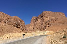
salut!tu compte marcher le long de la route ou a travers champs?
parceke il ya une importante denivele et je doute kil y est des chemin de randonnee.
il ny a kune seule route nationale ki traverse les montagnes du rif de chefchaouen a ketama.
les montagnes du rif c l equivalent d 1 departemen francais et 90% de la population vit de la culture du cannabis, donc ne t etonne pa si on ten propose le long de cet route!
si sa ne t interesse pa..tu na ka simplemen refuser (a te voir marcher au bord de la route avec ton sac je doute kil te propose gran chose)
les marocains du rif son des commerciaux il parle le francais, l espagnol et meme l italien donc pa de souci pour te faire comprendre.
pour le reste c comme partou on fai de bonnes comme de mauvaises rencontres!!
Je suis originaire du Rif et je voulais réctifier quelques clichés. Les Rifains ne vivent pas tous de la culture du H, loin de là. Il faut distinguer ka région de Ketama, bien connue pour ce type de culture, du reste du Rif qui ne vit pas de ce genre de trafics.
Pour la rando, mieux vaut tout de même éviter de s'aventurer trop en profondeur dans les montagnes du Rif, seul. Privilégiez les plaines semi montagneuses, Tastit, Kassita, Midar, Temsamen, Al Hoceima, Nador et d'autres petites villes très intéressantes ou les gens sont très accueillantes.
Bonjour,
l'année dernière, fin avril, j'ai marché 2 semaines dans le rif occidental pour rejoindre la mer. J'étais seul et je n'avais pas de carte, seulement quelques noms de villages . Je n'ai eu aucun problème particulier. Il faut tout de même savoir se repérer avec une boussole et se contenter de peu notamment pour manger car je n'ai pas trouvé d'épicerie dans les villages.
Pour moi les 2 dangers sont le chergui (un brouillard qui se forme près de la côte et dans lequel on est trempé jusqu'aux os en moins de 2) et certains chiens qui défendent vraiment leur territoire.
Est-ce que quelqu'un a déjà fait ce trek dans l'Atlas au Maroc: Traversée N- Sud Atlas central de Zahouia à Boutaghar avec M'goun (sommet et gorges)? Nombre de…
Quelqu'un a t'il déjà fait la traversée intégrale nord-sud, à pieds, de l'erg chebbi qui fait à peu pres 20 kms de long à vol d'oiseau. Est ce faisable en une…
Nous sommes un groupe de 6 personnes et nous préparons actuellement notre premier séjour au Maroc qui aura lieu du 1er au 18 Aout prochain. J'ai beaucoup…
je conseil vraiment de le faire a pied et non en 4x4 a moins d etre faignant bien sur, mais en prennant le temps la nature et le calme sont magnifique et les…
J'envisage de traverser le maroc a pied par l'atlas et le rif genre agadir-tanger départ mi -avril si quelqu'un a déjà fait ca ou un bout j'ai quelques? dans…
Bonjour,
Nous souhaitons faire le trek de 4 jours reliant Mestia à Ushguli sans agence. Il est précisé dans les descriptifs qu'il existe des hébergement à chaque étape, mais on ne trouve pas d'info sur ces hébergements. Quelqu'un a-t-il des infos et un avis sur ce parcours?
We're planning to trek in Peru and Bolivia and would love to find some local agencies.
If you know any, could you share details on prices and, of course, the names of the agencies?
Which trek would you recommend?
Elocine
Je pars en autonomie totale sur un trek au Maroc (10jrs) Imilchil - Aghbalou.
Trouve t-on des cartouches gaz à vis (Coleman, Primus) à Marrakech (adresse) ou villages entre Imilchil - Aghbalou ?
Si non , trouve-t-on des cartouches Butagaz pour camping-gaz (petit volume 230 gr ...)
Merci d' avance pour vos réponses
Hello, I’d like to embark on a little trip in my home country, Switzerland. I’ll start walking from La Cure, heading toward Le Noirmont first, then I’ll improvise my route—but it’ll probably follow the French border... at least as far as Lac de Joux.
I’ll decide day by day how much farther to go after that. My goal is to stay in nature as much as possible, wander around for as long as I can, and restock food in villages or towns along the way.
I’m thinking of mostly camping, but we’ll see if I end up in a hotel or another campsite depending on my route.
I’d love to reach La Chaux-de-Fonds on foot... maybe even Delémont.
The whole thing should take about a week, give or take.
I’ll be bringing my dog, and I’m preparing for this as soon as I’m ready.
Any tips to make sure everything goes smoothly for us? Things I should know—or avoid? What about shepherds with their flocks of sheep? And isn’t hunting season open right now?
I’m not sure if what I’m planning is even doable, which is why I’m asking around.
This’ll be my first time doing something like this—wandering in nature *and* with a dog. I’m really excited for this adventure... and I need it. Thanks!
We’re really keen on ecosystems and want to hike in "natural" ancient forests—not planted woods or areas heavily degraded by human activity. Travel guides (like Lonely Planet) don’t provide much info on this. Could you point us to the most interesting spots?
Thanks in advance for your tips.
We wish you happy holidays and a fantastic 2026, full of discoveries!
Claire and Albert
Hi, this might not be the right section, but I’d like to know if it’s possible to start mountaineering with another person without necessarily hiring a guide. We’ve done quite a bit of hiking but not mountaineering—we’ll just do a half-day glacier course. After that, we were thinking of starting with La Grande Motte and the Pointe de la Traversière, which were recommended to us. Honestly, for things like roping up and knots, I’ll learn at home with lots of videos and a book.
Hi,
I don’t know Switzerland at all and was wondering if Vallée des Joux and especially Dent de Vaulion are packed early in the morning or late in the afternoon in July and September?
If so, do you have any quieter spots to recommend in the area, or in Luxembourg (yes, I know it’s not the same country 😉)?
Thanks a lot!
Jaimerais savoir si quelqu'un aurait fait des treks sur le Ruwenzori et combien ça coute en moyenne, les infrastructures, les paysages la sécurité sur les lieux, merci beaucoup. J'attends avec impatience vos réponses.
We’re leaving in 9 days for a two-week trip to Madeira, mainly to hike.
From my research, I’ve found that since last year, access to most trails—and systematically for the most popular ones—is now paid. You have to pay an access fee of 4.50 € per person per classified hike in 2026, and even 10.50 € for the most iconic hike: Pico Arieiro to Pico Ruivo. When paying, you also have to choose a day and a 30-minute time slot for your start time. Of course, this reservation is neither changeable nor refundable, even if the weather that day is terrible.
Personally, given the massive influx of tourists to the island in recent years, I don’t mind paying a fee to help maintain the trails. Similarly, setting a limit on the number of people who can hike them per day is certainly preferable to preserve this priceless heritage.
However, what’s much less fair is that in reality, most of the available spots are reserved: 1/ for Madeira residents (which is normal); 2/ for "economic operators" (meaning local tour operators). For example, if you’re a non-resident (independent tourist), no booking is possible for the Pico Arieiro hike for an early morning start before September! So, unfortunately, we’ll have to skip this hike.
It’s the same issue for Ponta de São Lourenço, the 25 Fontes, Pico Ruivo... in short, all the most popular hikes. Oh well, we’ll skip those too!
So my question is: which hikes do you recommend where we won’t face the huge crowds that the others get? And where we can book the day before for the next day, taking the weather into account?
Finally, a quick accommodation question: we’ve booked the first week in Funchal, but I haven’t decided yet for the second week. Do you have any advice on where to stay in the south or north, preferably avoiding overly concrete-heavy and touristy spots?
I’m reposting about the logistics for Samaria Gorge.
I’d love to get recent info, especially about whether it’s possible to park my car in Omalos, do the hike, and then catch a bus back to my vehicle.
In theory, it’s doable, but when you check the KTEL website, there aren’t any feasible schedules listed. If anyone has recently organized this with reliable, verified details, I’d really appreciate it. Thanks in advance!
Hi there,
We’re flying from Montreal to Lyon this August to go hiking in the French Alps. We’ve rented a car and will be staying at campgrounds. We’re planning to do day hikes and want to stay a few days in one spot, do a few hikes, then move on to our next camping spot. Could you share your favorite spots or any recommendations for places to spend a few days with great hikes?
A few details:
We arrive in early August and leave in early September.
We’re looking for day hikes (or shorter), moderate difficulty, with a cumulative elevation gain of no more than 1000m, and of course, beautiful scenery!
We’d prefer not to drive too much—maybe it’s best not to head too far south and deal with unnecessary heat?
Along the same lines, if you know of any great campgrounds where we can start our hike directly without needing the car, we’d love to hear your suggestions!
Bonjour
Souhaitant faire de la randonnée sur cette île, je voudrais d'abord savoir quelle serait la période la plus favorable sachant que j'avais passé quelques jours en novembre 2018 pas pour cette activité mais plus pour une simple découverte de l'île et le temps n'était pas top notamment en montagne. Donc peut on choisir une organisation en étoile sachant que je louerai un véhicule avec éventuellement 2 points d'hébergement.
Je n'envisage pas d'intégrer une structure mais de partir à 2 et de s'organiser sauf si vous me conseillez une agence locale ou un guide local. Enfin même si je compte me procurer les différents supports, carte et topo guide plus gps je vous remercie de bien vouloir me communiquer les randos à faire en priorité
Merci beaucoup pour vos informations
I’m planning to do the Mercantour crossing following the Randoxygène route in mid-July.
I’m used to hiking in the mountains, but I sometimes get vertigo, for example on ridges with drops on both sides. I wanted to check if there are any T4 or T3-T4 sections and find out if there are any very exposed passages—and if so, where—so I can plan an alternative route.
Can anyone give me some info on this?
Thanks!
I’m planning a trip around Cap Corse and the AGRIATES in 2026, from May 8th to 15th (there are still 2 spots left, by the way! Just DM me if you're interested).
I’d love to know which hikes are worth prioritizing in the AGRIATES. We’ll be staying in SALECCIA for two days as our base—what should we focus on from there?
A round trip to IGNHU beach? Any other suggestions?
For Ostricano, I think it’s too far for a round trip...
Thanks for your tips!
Have a great day,
Anie, Toulouse
I’d like to get some info about the GR10 Pyrenees traverse. I need help planning the daily stages and accommodations—my wife isn’t an experienced hiker but walks a lot, so I’d like to schedule shorter walking days and thus a longer overall trip in terms of number of days.
Could anyone give me some help and advice?
Best regards,
New to this forum, I’m planning a pretty big project for 2028.
I’m heading to Nepal to do a trek from Kathmandu all the way to Everest Base Camp (a cool 5,300 m 😄).
This trek is a bit special because even though I’ll be part of a group, I’m going solo (so far, no problem—I’m used to it). But it’s my first real trek, and it’s also a humanitarian one: once I reach base camp, I’ll stay an extra week to help clean up the waste left by tens of thousands of climbers! Since I’m originally from South America, from two countries that share the Andes, I have a deep respect for mountains—they fascinate me. So Everest… it’s kind of the trip of a lifetime!
So, a little question for those who’ve done treks to Everest before… any tips for good mental preparation (I’m already working on the physical side)?
Hi there, I’m planning the Annapurna Circuit for March 2027 and I’m looking for a local agency with a local guide—preferably French-speaking—to arrange this trek for us. Any suggestions? Thanks
Hello!
We’re spending a few days in Toraja country at the end of May. We’d love to do a day trek—taking our time—on a route that’s stunning in terms of scenery, but not a level 5 in difficulty!
Any suggestions you can share, please?
Thanks in advance
I’d like to do the Mare a Mare Sud in May over 4 days. I’ve found quite a few places to stay along the route, but I’m stuck on the start and finish.
I’ll be arriving by plane on Sunday evening and would like to start pretty early on Monday morning. Ideally, accommodation right at the trailhead (Alzu di Gallina) would be amazing, but I can’t find anything. Any tips?
Also, for the transfer from Figari Airport to Porto Vecchio or Alzu di Gallina?
At the end, I’d like to pick up a rental car—any advice on that too?
I’m traveling solo by plane to Catania in May and plan to hike the northern side of Etna, starting from Linguaglossa where I’ll arrive by bus. After that, I’d love some info on how to get up to Piano Provenzana (shuttles or hitchhiking), since it seems there’s no public transport except in the summer. Can you sleep there in a free or cheap refuge, or camp? And how far up can you go without having to hire a guide? Thanks in advance. Bernard.
Bonjour a tous,
je pars en voyage au Maroc en aout et nous allons commencer par nous arrêter a Chefchaouen(nous sommes en voiture).
Ma question: quelqu'un peut il m'indiquer un itinéraire de rando en boucle d'entre 5 et 7 jours aux départ de Chefchaouen dans le parc de Talassemtane passant si possible par le pont de dieux?Ou un guide papier qui en reunis quelques uns?
Nous privilégions le camping sauvage et les gites.
Merci d'avance
Hi there, for those who’ve been recently—is it possible to find other solo travelers in March on the island to share transport or room costs? It doesn’t seem easy to travel on a budget.
If you have any recommendations for simple lodgings or places with dorms, I’d love to hear them.
For those who’ve done multi-day treks while moving around: do you need to bring your own sleeping bag? I’d love to hear about itineraries you’ve done without a guide, just with a map and GPS.
Thanks, and have a great day!
Hi everyone!
We’re planning a 15-day road trip to Scotland this summer, specifically to explore and hike on Lewis and Harris—places we’ve never been before. We’ve visited other islands on previous road trips in Scotland (we usually go in April for a week). This would be our first time in Scotland in the summer and for 15 days. We’re looking at late August to early September.
I’m currently drafting the itinerary. We’d be crossing from Ullapool and were thinking of spending 3 nights on Harris and 4 nights on Lewis.
Does that sound balanced to you? Is it better to keep the same accommodation on Harris and the same on Lewis to explore the area? I’d love to hear about any past experiences you’ve had on these islands.
Thanks!
Hi there, I’m trying to leave for 15 days very soon to São Vicente. I’m either looking to join an agency or figure things out on my own to go hiking on one of these islands or both. From what I’ve seen, it’s not easy to organize with local transport, so it gets expensive. Can I use the services of a small local agency? I’m looking for the simplest way to hike for several days. Also, how do you get from São Vicente to São Nicolau? Thanks in advance and have a great day!
Aichatou
I’ve been wanting to do this for several years, and this year’s the one. Next September, I’ll be trekking in Tusheti (Georgia), from Omalo to Shatili.
Of course, I won’t be renting a vehicle that’d just sit unused. No problem getting to Pshaveli, but from there to Omalo, it’s a dirt road (still the case?)
There must be some form of public transport since there are so many guesthouses, and not all travelers come in a 4x4.
If any of you have been to Omalo, could you confirm that these shared transports exist and how often they run?
we’re planning a trip to Yellowstone and hoping to do a three-day backcountry hike if we get a permit.
if any of you have done this before, could you let me know if it’s possible to find water along the way? And if we can transport it, are we allowed to use a stove?
Hello,
I’ll be in Nepal from March 6th to 29th (we’re flying into Kathmandu via Varanasi and leaving via Delhi).
I’m a bit confused about the regulations requiring a guide.
My wife and I (we’re 63 and 64) aren’t experienced trekkers—we’re more used to walking on terrain with very moderate elevation changes. I’m looking for fairly easy hikes, possibly day trips.
Here are my questions:
- Does the Poon Hill trek from Pokhara require a guide, or is it better to go through a local agency? (I’ve seen a lot of them offering 4-day packages)
- I’d like to do a few multi-day hikes around Jomsom (Kagbeni, Mukitinath, Lupra, Marpha)... Do you need a guide for those, and can you find accommodations easily without booking in advance?
Last question—I’m really hesitant to lug around a sleeping bag or down jacket during our 6 weeks in India. Can you easily find these kinds of items at reasonable prices in Pokhara?
Thanks in advance for any tips you can share!
Yann