Bonjour à tous
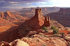
Cette année, Valley of Fire est (enfin!) au programme. On y consacre une journée pleine, pour pouvoir y faire quelques randos dont Pretzl Arch et Crazy Hill Trail. Point de départ facile à localiser MAIS: j'ai lu sur certains sites, mais pas tous (justement), que ces sentiers sont peu ou pas balisés, et qu'un GPS de rando est + que conseillé pour trouver les points d'intérêt, à savoir Pretzl, Fire Cave, Thunderstorm Arch et Crazy Hill.
N'étant pas pro de l'orientation, je me méfie beaucoup des indications genre "descendez ds le ravin et vous devriez voir....".
Merci à ceux qui connaissent ces trails de me dire s'il faut absolument un GPS ou pas. (n'en ai pas et n'en ai jamais utilisé)
Mon expérience :
Même avec un GPS on peut passer à coté ! 😉 🤪
Donc : ceinture et bretelles = cartes et GPS ! 😇
(mais on peut utiliser celui de la voiture si les distances ne sont pas trop grandes, autonomie limitée...)
Cf : http://voyageforum.com/v.f?post=4613159;page=last;#last
Avec les cartes les repères sont sans doute pas faciles a suivre c'est ça ?
Un GPS , si tu entre la longitude de la latitude où tu veux te rendre , le GPS va t'y amener .
Si par contre tu lui demande simplement le parcours et que le gps n'est pas a jour ( des erreurs non corrigées ou ....) tu auras en effet de la difficulté.
Suis-je dans l'erreur ?
Je connais beaucoup de gens qui ne connaissent pas ça faire des mises à jours de gps .
J'utiliserais mon gps de voiture en entrant la longitude et latitude .
Le vol est trop important dans un voyage pour ne regarder que le prix.
Les GPS de voiture ne sont pas top pour la rando ... J'ai essayé avec le mien, il me dit "impossible de trouver le point patati patata" ou "le point ne se trouve pas sur une route" ...
Le mieux c'est vraiment GPS de rando avec carte topo de rando.
Comme le dit Thibaut, Pretzl, Fire Cave, Thunderstorm Arch et Crazy Hill ne sont pas des spots répertoriés officiellement... donc, il n'y a ni sentier, ni indication, ni repère... et comme ses spots sont encore confidentiels, il n'y a pas grand monde non plus (déjà que Valley of Fire n'est pas un parc immensément visité...)
Donc, sans GPS, le risque est grand de faire bcp d'allers-retours pour les découvrir .
Le seul point positif, c'est qu'il n'y a pas une très longue marche pour découvrir Fire Cave, Thunderstorm Arch et Crazy Hill, et qu'en furetant, et avec de la chance, il est peut-être possible de les découvrir, même sans GPS (mais faut du courage pour faire ces allers-retours sous le soleil et avec la chaleur qui règne ds ce parc).
Quant à Pretzel Arch, je pense qu'il n'y a aucune chance de la découvrir sans GPS
Ouest USA 2009 https://voyageforum.com/v.f?post=2800143#2800143
5ème trip USA, 09/2013 https://voyageforum.com/v.f?post=6186946#6186946
Les GPS de voiture ne sont pas top pour la rando ... J'ai essayé avec le mien, il me dit "impossible de trouver le point patati patata" ou "le point ne se trouve pas sur une route" ...
Le mieux c'est vraiment GPS de rando avec carte topo de rando.
Tu as indiqué la latitude et la longitude pour le gps de voiture ?
Évidemment l'idéal est un GPS de randonnée en souhaitant qu'il t'y amène parce que ce n'est pas donné ces trucs
Le vol est trop important dans un voyage pour ne regarder que le prix.
Merci à tous les 3. Bon, ça ne va pas être simple...😠 car je n'ai fait jusqu'à maintenant que des randos bien balisées...pour lesquelles je n'avais pas besoin de cartes (juste les schémas des brochures des visitor center). Cela dit, j'ai quand même réussi à nous perdre sur un petit trail à Kodachrome, donc il va falloir qu'on s'améliore. Je vais donc poser des questions idiotes: les points d'intérêt que je vise, comme les arches, ou Crazy Hill, figurent-ils sur ces cartes (😊)??
Itat, j'en profite pour te remercier/féliciter pour ton super site qui en aide plus d'1 à préparer ses visites, y compris moi. M'en suis beaucoup inspirée cette année pour Valley of Fire justement et Yosemite. C'est juste dommage que tu n'aies pas mis des cairns sur les randos dont je parle😉
Je vais visiter les liens de Stratele voir si ça m'aide et réfléchir au GPS, pour lequel j'aurai sûrement d'autres questions.
Lis surtout le lien que t'a indiqué Pong http://voyageforum.com/v.f?post=4613159#4613159 ... et si tu n'as pas le courage de lire ttes les pages pour connaitre la chronologie de la découvertes de ts ces spots, cours directement à la page 8 et suivantes😉
Ouest USA 2009 https://voyageforum.com/v.f?post=2800143#2800143
5ème trip USA, 09/2013 https://voyageforum.com/v.f?post=6186946#6186946
Pour rater Crazy Hill il faut vraiment le faire exprès même sans GPS (je n'ai pas utilisé mon Etrex pour cette balade des 7 merveilles) - Thunderstorm Arch est un peu plus délicat à découvrir.
La carte de Pong et hop en route!
Vous ne serez jamais loin de la route ( 400 -500m maxi) - méfiez vous par contre de la chaleur intense.
L'accès à Fire Wave est "cairné "par des poteaux métalliques 😎.
Si vous vous décidez à utiliser un GPS de rando, exercez vous avant de partir.🙂
Je me souviens d'avoir lu ta réussite de découvrir ces spots sans GPS... mais tu es peut-être (sans doute😇) doué
Voir une autre expérience moins réussie http://voyageforum.com/v.f?post=6167302#6167302
"L'accès à Fire Wave est "cairné "par des poteaux métalliques "
Fire Wave oui... mais pas Fire Cave
Ouest USA 2009 https://voyageforum.com/v.f?post=2800143#2800143
5ème trip USA, 09/2013 https://voyageforum.com/v.f?post=6186946#6186946
Évidemment l'idéal est un GPS de randonnée en souhaitant qu'il t'y amène parce que ce n'est pas donné ces trucs
j'ai acheté le mien (neuf) à 100euros sur leboncoin.fr...et les cartes gratuites (légalement) existent
Tu as bien raison , c'est très raisonnable comme prix .
Une petite recherche chez un fournisseur de ma région , ces gps commence 85 euros et vont jusqu'à 550 euros . Il n'y en qu'un en bas de 100 euros et la plupart 300 euros . Et quand j'achète je ne vise pas le moins cher mais le milieu et plus , c'est sans doute pour ça que j'ai retenu 300 euros et que je trouve ça c'est cher si ça ne fait pas toujours le travail
Le vol est trop important dans un voyage pour ne regarder que le prix.
Vu la carte (p8) et les coordonnées GPS. Vu aussi d'autres liens qui parlent du circuit des "7 merveilles".
Je vais creuser tout ça car pour l'instant ça ne suffit pas, sauf si je prends un gps et que ça marche bien. J'ai pas encore trouvé une carte qui me renseigne "suffisamment", car je ne veux pas passer à côté🙁. Et même si j'ai un gps, j'aimerais bien avoir aussi et prioritairement une carte. Peut-être le lien de Stratele, mais il faut s'inscrire... ça va se faire.
A suivre...et merci encore.
C'est vrai qu'avec la carte fournie par Pong, je pense quand même que la probabilité de passer à côté des merveilles est quand même faible et puis acheter un GPS de rando que pour ça .. ça fait quand même cher le coût de revient de chaque merveille 😉
A moins que ... ça ne te donne des ailes du coup pour sortir des sentiers battus et visiter d'autres sites avec ton nouveau gadget 😎
Salut Jean-Philippe
Oui, c'est vrai que l'investissement m'ennuie un peu parce que c'est le seul endroit du parcours (cette année!...) qui nécessite cet équipement.
C'est pour ça que je vais essayer de trouver une carte détaillée. J'ai vu une carte dans un post de Pong en suivant les conseils, mais je ne suis pas sûre que ce soit celle-là dont vous parlez tous. Donc je vais continuer mes recherches avant de poser d'autres questions. En tous cas, d'une manière ou d'une autre, je veux arriver à dénicher ces sites!
L'idée, déjà cette année et pour l'avenir, est de faire bcp moins de km en voiture pour en faire davantage à pied, explorer plus à fond les lieux, autour de Moab, Escalante, et ds les San Juan Mountains entre Telluride et Silverton (ça on teste cette année).
En réflexion!
"L'idée, déjà cette année et pour l'avenir, est de faire bcp moins de km en voiture pour en faire davantage à pied, explorer plus à fond les lieux, autour de Moab, Escalante"
Alors achetez un GPS, il deviendra de tte façon indispensable 😉
Au 1er voyage, ns avons fait sans (se disant comme vs, que ce n'était pas nécessaire...)... et on a loupé la "House of Fire"🤪
Pour le 2ème voyage, ns avions un Smartphone avec fonction GPS; et plus ns voyageons ds l'ouest américain, plus il devient obligatoire pour explorer le wilderness sans stress
Ouest USA 2009 https://voyageforum.com/v.f?post=2800143#2800143
5ème trip USA, 09/2013 https://voyageforum.com/v.f?post=6186946#6186946
Doué, sûrement 😊 ... ou alors avec une dose de réussite aussi insolente qu'inattendue et forcément ... imméritée!
Un peu de bon sens, une observation rigoureuse du tracé, un examen attentif du relief avant le départ sur la carte ET sur le terrain, un soupçon de chance et tout va bien... on n'est qu'à 4 ou 500 de l'asphalte.
Les principaux obstacles ne sont ni l'orientation, ni la distance, ni les dénivelés mais bien la chaleur et j'insiste une fois de plus là dessus. J'ai relu ton lien: démarrer cette balade à 10h30 ou 11h du matin en plein été, c'est de l'inconscience, sauf équipage entraîné ... et plus jeune...
Cette boucle, ce n'est ni Bisti Badlands ni son cousin ...
Acheter un GPS ? juste pour cette rando? si ça peut rassurer ... il ne faut pas s'imaginer non plus qu'on va tomber pile poil à 5cm près.
Alain
PS je me demande si cette rando n'est pas plus aisée à parcourir en commençant par Fire Wave (je n'ai pas confondu avec Fire Cave😉) hop, on file sur Pink Canyon- au sortir on croise la route - Striped Rock n'est pas loin - et on remonte par Crazy Hill - facile non? 😎 seul souci, on ne "tombe" pas sur cette glace fraise, abricot, vanille qui fond au soleil ... comme en commençant de l'autre sens.
Un peu de bon sens, une observation rigoureuse du tracé, un examen attentif du relief avant le départ sur la carte ET sur le terrain, un soupçon de chance et tout va bien... on n'est qu'à 4 ou 500 de l'asphalte.
BonsoirDésolée mais là...je crois qu'il y a vraiment quelque chose qui m'échappe🏴☠️ : vous dites "une observation rigoureuse du tracé": d'accord, mais : sur quoi suis-je censée "observer le tracé"? Moi je m'imagine une carte style nos cartes IGN. Comment puis-je utiliser la carte de Pong? Désolée encore une fois pour ces questions stupides, mais j'aimerais bien comprendre...
Tu as raison de poser la question car peut être que chacun de nous a une stratégie différente. La meilleure étant celle qui te sied le mieux ...
Pour ma part, si je n'avais pas de GPS de rando ... Je prends la carte de Pong, j'ouvre Google Map ou Google Earth et je retrouve la zone concernée (assez rapidement car on voit bien la route en cul de sac qui mène à White Domes). De là, je zoome sur des parties de la boucle : tu vas vite apercevoir le radier sur la route par exemple peu avant le parking pour Fire Wave. Et puis, je fais des "copie écran" que j'imprime. ce qui peut résulter en 10 pages par exemple rien que pour cette boucle. Ces parties agrandies sont après plus facilement exploitables sur le terrain...
Nous étions à Vof il y a qqs jours, je ne vois pas comment nous aurions pu faire cette fameuse boucle sans le GPS ! Par contre, nous n'avons pas investi dans un GPS de rando mais dans une appli smartphone (maps 3D) largement suffisante (entre 3 et 5€). Tu peux charger les cartes gratuitement. Par contre, il faut un peu de temps pour le prendre en main, qd même pas évident.
Hello Laure...et bonjour à tous
Merci pour le tuyau smartphone. J'ai installé ViewRanger et trouvé gratuitement la carte USA, avec oh miracle le tracé du circuit des 7 merveilles avec les noms indiqués! Trop bien! Nous reste à nous familiariser avec cet engin là, c'est au programme du we, les choses avancent🙂
J'ai bien conscience qu'il fait très très chaud par là-bas (on y sera mi-août), c'est pourquoi j'envisageais de démarrer la journée par cette rando là pour continuer par les points de vue ou courts trails au + fort de la chaleur; on sera à végas la nuit d'avant, je pensais attaquer la rando à 7h30 au + tard, pour finir à 11h maxi en tenant compte des arrêts photos, hésitations de parcours...Cela vous paraît-il raisonnable et faisable?? (je précise qu'on ne peut pas faire la rando le soir compte tenu de l'étape suivante, ce qui pourtant aurait été l'idéal pr la lumière, tant pis 🤪)
3h30 pour faire la boucle me semble un peu large, je pense que tu peux enlever 1/2h - 1h (nous l'avons fait en 1h40 mais au pas de charge 🤪 parce ce que je voulais arriver pour le sunset à fire wave 😇 )
Par contre, dans l'après midi tout était dans l'ombre, à part la vague, donc peut-être le matin ne serait pas si mal...
Si le voyage est prévu en juillet-août, il fera déjà très chaud à VoF à partir de 9h00
(voir notre expérience en septembre où il fait un peu moins chaud qu'en juillet et où pourtant à partir de 9h00, c'était déjà la fournaise http://voyageforum.com/v.f?post=6189597#6189597)
L'idéal (pour éviter la chaleur et avoir de belles couleurs) serait de quitter Las Vegas aux 1ères lueurs de l'aube, voire même plus tôt pour assister au sunrise là-bas
(voir expérience de Cendryon http://www.frontiereland.be/photos/ouest2/jour4.htm)
Si tu ne fais que la "boucle aux 7 merveilles", il ne faudra pas 3h30... mais c'est vrai qu'il y a aussi tt le reste (et qu'il est très facile de passer 1 jour entier ds ce parc pour tout voir)
Ouest USA 2009 https://voyageforum.com/v.f?post=2800143#2800143
5ème trip USA, 09/2013 https://voyageforum.com/v.f?post=6186946#6186946
Si vous avez prévu 2 nuits à Las Vegas, vous pourriez reporter la 2ème nuit à Overton afin de profiter de Valley of Fire SP en fin de journée + le lendemain matin de très bonne heure. Nous avons dormi au motel "North Shore Inn at Lake Mead", bon rapport qualité/prix et petit-déjeuner sous forme de buffet compris dans le prix de la chambre.
Hello
Rentrés depuis 15 jours... Petit retour sur VOF et la rando des Merveilles...que bien sûr on n'a pas faite!!! Enfin côté ouest de la scénic drive. Problème d'utilisation de ViewRanger : soit on est des vrais boulets soit l'appli est moyenne (directions incohérentes)...sûrement un peu les 2! Bref, ça ne nous a pas empêchés d'apprécier : grosse claque, c'était vraiment magnifique, l'un des tops de cette année. On y était à 6h du mat, vu Striped Rock en 1er en remontant la scenic drive, lumière ++. Puis belle balade White Dome, on a pris notre temps. Puis Fire Wave prolongée (quand même🤪) par Pink Canyon, et remontée au parking par la route. Fire Canyon Arch, trouvée grâce aux explications des internautes, car l'appli nous envoyait à droite à gauche...La loop drive...vu des bighorn sheep...Elephant Rock...Pas grand monde...un must!
Merci encore pour l'aide apportée, on va continuer à progresser pour l'année prochaine😏
J'ai prévu de visiter Monument Valley samedi prochain après 3 jours au Grand Canyon, j'ai vu sur le site navajonationparks.or... qu'il peut y avoir des chemins…
J'ai réservé depuis plusieurs mois un tour avec Monument Valley Safari pour le 02.08.2020 malheureusement mon vol est annulé et je ne pourrai donc pas faire ce…
Nous envisageons d’aller à Monument Valley depuis phœnix et ensuite direction Moab puis Las Vegas. Nous connaissons un peu ces destinations mais uniquement en…
Livres, films et documentaires › États-Unis · 0 replies
Je m'appelle Charlotte Mattout et je suis journaliste pour France 2. Nous cherchons une famille ou un groupe de Français qui vont visiter Death Valley bientôt…
Hello! The itinerary is pretty much set for August 2026. Yeah, I know it’s gonna be *super* hot. But it’s the only time we can get away.
So, here’s the plan: Montpellier-CDG-Dallas.
Stay from July 31 to August 26, 2026:
Car rental – check,
Hotels – check,
Itinerary – almost check,
Photo gear – check,
Budget – check, 🤪
Meal planning – meh, we’ll see...
Walmart, of course, for the cooler when we arrive.
And now, without too much detail...
Fort Worth:
The Longhorns and the Stockyards;
JR’s ranch (for the missus);
Medal of Honor Museum – Arlington.
Houston and NASA Space Center:
See the Gulf of Mexico/America.
San Antonio and the missions.
Fort Stockton for an overnight stop.
El Paso via Guadalupe Mountains:
El Paso and White Sands.
Tucson and the Pima Air & Space Museum:
Tombstone, Bisbee.
Phoenix:
Still working on the program.
Sedona:
Round trip around the area via Flagstaff and Williams, or the Grand Canyon (already done) – we’ll decide on the spot.
Albuquerque:
Santa Fe,
Turquoise Trail,
Los Alamos.
Amarillo via Route 66:
Old Route 66 in the city;
Big Texas Ranch Steak 😏.
Dallas:
JFK Museum;
Perot Museum;
West End district.
And through it all – the road, the road, and more road!!!
We’ll adapt day by day based on our mental and physical state (we’re not exactly spring chickens).
Hello everyone! Really damaged due to flooding caused by runoff after forest fires (a total mess!), does anyone in this friendly forum have any updates on the Apache Trail between Apache Junction and Roosevelt Dam? Is there still a section of the road that’s tough to navigate?
We're leaving at the end of June and will be driving the route between Buffalo and Cody. We’ve already booked our accommodations and a rodeo in Cody, but during the day, we’ll be driving between the two and I’m unsure about the itinerary.
Which route do you think is the most pleasant, interesting, or scenic between:
- The northern route via Highway 14 with Sheridan, Lowell, etc.
- The southern route with Highways 16/20/14, passing by Loaf Mountain Overlook, Powder River Pass, Ten Sleep Canyon...
We’ll be in a car, so we should be able to drive on any road.
Thanks for your input!
I’m almost done planning our September road trip. After our 3-night visit to Sequoia, we’ll have a stopover night in Coalinga (to break up the drive). We’ll be staying two nights in Monterey and would like to stop along the way to visit one side of Pinnacles National Park. We’re torn between the West entrance and the East entrance, and we’d like to do a short hike of no more than 2 hours since we don’t want to arrive too late in Monterey.
This park is split into two distinct zones with no connection between them, and the mileage from Coalinga to Monterey is pretty much the same for both. Which area do you recommend visiting—east or west? And which route is the most scenic?
I’ve spotted two short hikes:
- East: Moses Spring to Rim Trail Loop
- West: Balconies Cliffs Cave Loop
Has anyone been there, or do you have another hike to suggest?
Thanks in advance, and have a great afternoon!
Marcalamar 🙂
After our first trip as a young couple to the West in 2007 (yes, that doesn’t make us any younger!), we’re planning to go back in 2028, but this time as a family of four! (We have two boys who’ll be 5½ and 13 years old in the summer of 2028.)
Our plan is to combine a few big cities (SF and LA, maybe San Diego) with national parks and state parks, mostly!
Ideally, we’d like to leave at the end of June and head back to France around July 19–20, so we can enjoy the first week of the Olympic Games in Los Angeles.
Since we already did the "loop" in 2007, there are must-see places we absolutely want to revisit—and especially share with our kids: Bryce Canyon, Yosemite, and above all, the Grand Canyon, which is still the most incredible thing I’ve ever seen on Earth!
On the other hand, some places didn’t leave a big impression on us for various reasons, so we’re not making them a priority: Antelope Canyon, Monument Valley, for example.
We’re planning ahead, but might as well be smart about it😏
Do you have any tips for a fun and doable itinerary over about 20–25 days with kids, without rushing?
Hi everyone! 🙂
Just a quick question about King Canyon and Sequoia National Park.
Before our night in Miramonte, we plan to visit King Canyon. The next stop will be two nights in Three Rivers to explore Sequoia National Park. I wanted to go all the way to Roaring River Falls on the King Canyon Scenic Byway and then turn back to head to Miramonte. Since we’re coming from Oakhurst, Google Maps says it’s 300 km and 5 hours of driving. Since we also want to hike to see the sequoias (Big Stump Area and Grand Grove) before tackling the King Canyon Scenic Byway, the timing’s going to be tight. How far do you recommend going before turning back to miss as few points of interest as possible on the King Canyon Scenic Byway? Thanks for your advice, and have a great evening!
Marcalamar 🙂
Hi everyone!
After years of hoping, waiting, planning, then changing, saving, and searching for the best possible route... we're FINALLY off this summer for a 5-week road trip in the West.
I had planned a trip to Colorado in 2021 but canceled due to COVID, so with time passing and my eldest’s high school graduation approaching fast, I figured it was now or never!
Anyway, the itinerary has been modified and extended to please everyone (I’m no longer the only one making decisions!!)
Here’s our final route:
Day 1 - 7/12/2026 - Brussels / Los Angeles
Day 2 - 7/13/2026 - Los Angeles
Day 3 - 7/14/2026 - Los Angeles
Day 4 - 7/15/2026 - Los Angeles
Day 5 - 7/16/2026 - Los Angeles
Day 6 - 7/17/2026 - Los Angeles / Kingman
Day 7 - 7/18/2026 - Kingman / Grand Canyon
Day 8 - 7/19/2026 - Grand Canyon / Page
Day 9 - 7/20/2026 - Page
Day 10 - 7/21/2026 - Page / Monument Valley
Day 11 - 7/22/2026 - Monument Valley / Durango
Day 12 - 7/23/2026 - Durango
Day 13 - 7/24/2026 - Durango
Day 14 - 7/25/2026 - Durango
Day 15 - 7/26/2026 - Durango / Glenwood Springs
Day 16 - 7/27/2026 - Glenwood Springs
Day 17 - 7/28/2026 - Glenwood Springs / Moab
Day 18 - 7/29/2026 - Moab
Day 19 - 7/30/2026 - Moab
Day 20 - 7/31/2026 - Moab
Day 21 - 8/1/2026 - Moab
Day 22 - 8/2/2026 - Moab / Vernal
Day 23 - 8/3/2026 - Vernal / Grand Teton
Day 24 - 8/4/2026 - Grand Teton
Day 25 - 8/5/2026 - Grand Teton / Cody
Day 26 - 8/6/2026 - Cody / Yellowstone
Day 27 - 8/7/2026 - Yellowstone
Day 28 - 8/8/2026 - Yellowstone
Day 29 - 8/9/2026 - Yellowstone
Day 30 - 8/10/2026 - Yellowstone / Salt Lake City
Day 31 - 8/11/2026 - Salt Lake City / Bryce Canyon
Day 32 - 8/12/2026 - Bryce Canyon / Zion
Day 33 - 8/13/2026 - Zion
Day 34 - 8/14/2026 - Zion
Day 35 - 8/15/2026 - Zion / Las Vegas
Day 36 - 8/16/2026 - Las Vegas
Day 37 - 8/17/2026 - Las Vegas / Los Angeles
Day 38 - 8/18/2026 - Los Angeles
Day 39 - 8/19/2026 - Los Angeles / Brussels
Day 40 - 8/20/2026 - Brussels / Home
We’ll be alternating between house swaps, motels, and campgrounds. I’ve booked all the accommodations (except the campground at Bryce since sunset bookings open only 14 days in advance) and the first activities, as well as the most touristy ones.
I’m currently putting together my day-by-day roadbook and having some trouble planning certain days, like in LA or Las Vegas. Choosing hikes isn’t easy either—it’s tough to decide!
We’re really excited but could definitely use your help with choices and optimizations!!
Hello.
I’d like to travel along I-15N from San Diego to Las Vegas with my mom, who’s 67. We’ve explored Northern California and the California Coast over the past two years and now want to continue through the desert.
There are several attractions along the way:
- Mormon Rocks
- Desert Discovery Center and visit the Old Woman meteorite
- Joshua Tree National Park
- Mojave Desert
- Mojave National Preserve
- Anza-Borrego Desert State Park
- Silverwood Lake
My mom has back issues that prevent her from hiking or walking on trails with elevation changes. Is it possible to visit these places by car, or are the routes flat enough?
I’d love for her to experience the desert with an itinerary adapted to her condition. I’m also open to other points of interest that aren’t mentioned. We have 3-4 days for the trip, so we’re not in a rush—just want to explore.
I’d love to take a road trip and visit Nova Scotia. I’d appreciate some info on the best cities to see and the most interesting spots. The trip should last about 10 to 15 days, staying in hotels or motels. Thanks in advance!
We’re being relocated to Saint Pierre and Miquelon.
We’ll be taking the flight from Nantes to Montreal and then from Montreal to Saint Pierre.
Could you recommend a hotel near the departure terminal that allows dogs?
Hi,
My 16-year-old son is flying to Grand Rapids with other kids his age. There’s a layover in Detroit. There’s no unaccompanied minor service available. Is it pretty easy to navigate Detroit Airport to catch the connecting flight to Grand Rapids (domestic flight)? There are several of them who speak English well.
Thanks for your replies,
Good evening, everyone! 🙂
Just a few last questions to wrap up our Lake Tahoe visit plans.
**Parking:**
We’d like to walk to Eagle Falls and then Eagle Lake. I’ve spotted two parking lots that seem close to each other and give access to the trailhead. Where and how do we pay for entry to Emerald Bay State Park and Inspiration Point?
**Viewpoints on the East Side:**
Are most of the viewpoints (Balancing Rock, Granite Cave, Bonsai Rock, etc.) right by the road, or do you have to hike to reach them?
**Donner Memorial State Park:**
Is it worth making a detour to Truckee to visit this park and the Truckee historic downtown?
Hi there. I'm shocked by the price of the Upper Antelope Canyon tour—$175 for less than an hour… You might say, "if you can’t afford it…" But the real question is whether it’s really worth it, because $350 for two makes me feel like I’m getting ripped off. For those who’ve done both Lower and Upper, can you tell me if the price difference is really justified? Thanks
Hi everyone! 🙂
As you can see, we're heading back from September 6th to the 27th.
Everything’s booked for September—flights, accommodations, and the car. As I plan, I’ll be asking the experts for help. This is our second trip to California, but most of the stops are new to us.
We’ll start directly from San Francisco to our first overnight stop, Davis, before heading to Lassen Volcanic Park for 4 nights. Our flight lands at 12:50 PM.
Here’s our itinerary:
Day 1: Davis – overnight stop
Day 2: Red Bluff – exploring Lassen Volcanic Park (scenic drive to Lake Helen)
Day 3: Susanville – scenic drive through the park via the South Entrance, points of interest, and hikes
Day 4: Susanville – Cinder Cone and Painted Dunes hike
Day 5: Susanville – Warner Valley (hikes)
Day 6: South Lake Tahoe
Day 7: South Lake Tahoe
Day 8: Mammoth Lake
Day 9: Mammoth Lake
Day 10: El Portal via Tioga Road
Day 11: El Portal
Day 12: El Portal
Day 13: Oakhurst
Day 14: Miramonte
Day 15: Three Rivers
Day 16: Three Rivers
Day 17: Coalinga
Day 18: Monterey
Day 19: Monterey
Day 20: San Francisco
Day 21: San Francisco
Day 22: Departure
For hikes in Lassen Volcanic Park, I’ve planned:
Bumpass Hell, Cold Boiling Lake (Day 2)
Paradise Meadow (maybe not going all the way), Devastated Area, and the loop around Reflection and Manzanita Lakes (Day 3)
Cinder Cone and Painted Dunes (Day 4)
Devil’s Kitchen and Boiling Spring Lake (Day 5)
I’ve read there are trails to access the trailheads for Cinder Cone (11 km) and Warner Valley. Are these easy trails for an SUV?
Are there any other must-see spots or things we shouldn’t miss?
That’s where I’m at for now. Thanks for your replies, and have a great evening!
Marcalamar 🙂
I’m a total USA addict. I’ve already done several road trips, including the East Coast and West Coast.
I’m here today because I’m planning to go back for another road trip on the West Coast. Possibly with one of my sisters and a couple of friends. It’s still just a plan for now, but I’m working on an itinerary in the meantime. Ideally, I’d leave in 2026, but I don’t have the exact dates yet—maybe April-May or September-October.
My last trip to the West Coast was in September 2014. We went for 2 weeks, but this time it’d be 3 weeks. What made me want to go back was simply a colleague who just left today. As I’m writing this, he’s on the plane. I’m so happy for him, but now all I can think about is going back.
Since I recently went to NY, I noticed that prices have really gone up. I assume the same is true for the West Coast? For 2 people over 3 weeks, what budget should I expect? We’re the type to watch our spending and find great tips.
I think we’ll arrive in San Francisco like the first time and leave from either Los Angeles or Las Vegas.
Merci de me conseiller pour la réservation pour la plus belle vue faut il réserver une chambre dans l'hôtel ou choisir une cabane ?
Prendre le petit déjeuner ou pas ?
Que pensez vous du restaurant ?
Hello, if the off-the-beaten-path enthusiasts are still around 😉, I’d love some info on tackling these trails. I’m not super familiar with the rules, risks, or what to expect—I’m looking for firsthand experience from folks who’ve done it on their own once or multiple times.
Hi everyone!
I’m planning a week-long family trip to NYC in October 2026. The focus is on museums and soaking up the New York vibe. I’ve been checking Airbnb, but the prices in Manhattan are through the roof. Since I don’t know NYC well, is it "wise" to look outside Manhattan? Any neighborhoods you’d recommend?
After our first trip to the West, we’d love to go back to see other must-see spots!
The stay would be from May 11 to 20, 2026—it’s short, but hey...
M11: Lyon to Las Vegas (overnight in Vegas)
T12: Route 66 – overnight in Grand Canyon (GC)
W13: Visit GC – overnight in Page
Th14: Visit Antelope Canyon / Horseshoe Bend – overnight in Monument Valley (MV)
F15: Visit MV – overnight in Moab
Sa16: Visit Arches / Dead Horse Point – overnight in Bryce
Su17: Visit Bryce – overnight in Zion
M18: Visit Zion / Valley of Fire – overnight in Vegas
Tu19: Return flight
What do you think? Could we add one more night somewhere? We’re not big hikers, so we’ll mostly explore the parks using shuttles.
Also, we’re all set—passports are good. Do you think one classic Visa card and one premium Visa card will be enough for coverage?
Thanks so much for your feedback, and happy holidays!
Hi North America forum crew,
Just a little post that might interest some of you:
Travelers to the United States | Photo Now Mandatory Upon Entry and Exit | La Presse
I assume many of you already know, but the America the Beautiful annual pass, which was $80, will increase to $250 starting January 1, 2026.
So if you're planning to travel before the end of December 2026, it's in your best interest to buy your pass in December 2025, since it will still cost $80 and be valid until the end of December 2026 if you purchase it in December 2025.
This price increase only applies to non-U.S. residents.
Additionally, for those who planned to visit just one park, a $100 surcharge per person will apply to access a list of 11 national parks...
For example, if there are 4 of you in a car, you’ll have to pay $35 + $400,
which comes to $435 to visit one of the 11 parks on the list (I don’t have all of them... Bryce, Zion, Grand Canyon, Yellowstone, Grand Teton, etc.).
Total madness.
The goal is to push people who only visit one park into buying the annual pass.
Last point: free entry days are over for non-residents!
Hi everyone, I’m traveling to Los Angeles and would like to rent a vehicle at the airport. However, I have a Boursobank Ultim deferred debit card, so I’d love to know if it’s possible for those who’ve experienced this recently. Thanks for the info!
I’m planning a week in S.F. in April 2026 and I can’t figure out how to tell the cable cars—of which I understand there are three lines—apart from the trams, which I think number seven. I can’t find their individual numbers or routes anywhere.
Could someone shed some light on this for me? Thanks in advance.
Wishing you all a Merry Christmas and a wonderful 2026 full of amazing travels.
Cheers,
Régine
Hi,
I’m planning a road trip through the American national parks starting from Denver in June 2026.
The price of the pass is jumping from 80 € to 250 € on January 1st, 2026!!!
Is it possible to buy the pass online before the end of the year to lock in the 80 € rate? If so, where and how do I go about it?
Thanks for your tips.
Arnale
I’m planning a road trip for July 2026 in northern Florida. Could you let me know if my itinerary makes sense?
Day 1: Orlando
Day 2: Amelia Island
Day 3: Amelia Island
Day 4: Tallahassee
Day 5: Panama City Beach
Day 6: Panama City Beach (visit to Destin)
Day 7: Crystal River (stop in Cedar Key on the way)
Day 8: Crystal River
Day 9: Anna Maria (stop in Clearwater)
Day 10: Anna Maria (St. Pete)
Day 11: Anna Maria
Day 12: Orlando
Day 13: Orlando
Day 14: Orlando
Day 15: Departure
We just finished 9 days in the American West and wanted to share our experience because we had an amazing time.
I know some of you might ask, why use an agency? Honestly, we didn’t really feel like doing all the driving and planning, especially since we didn’t know the area at all. And since our English isn’t great, having French-speaking guides was a big comfort.
We found Emmanuelle and Isabelle, and wow, they were fantastic. It was just the two of us with them, so it was a truly VIP, ultra-personalized experience. They treated us like royalty from start to finish. These two live in Las Vegas and know the region like the back of their hand. They told us they’ve spent over 15 years exploring every corner of the American West, and it really shows. Their knowledge of geology, park history, and local anecdotes is just impressive. It’s nothing like someone reciting a memorized script. They answer all your questions and really adapt to what you want to see or do.
What we really loved: the vehicle was super comfortable, and the little details made a difference—like snacks and even a homemade cake! Though, to be fair, we devoured the cake right away, so that counts.
Since they know the sites inside out, they took us at the right times to avoid crowds. So we could enjoy peaceful picnics at Grand Canyon viewpoints without being packed in with 200 people. Plus, on top of the must-see spots, they showed us some hidden gems that were absolutely stunning—places we never would’ve found on our own. They’re true locals who know all the best tips.
The service was really personalized. They adapted to our pace and preferences, and we could stop whenever we wanted to take photos. It’s the luxury of being in a small private group—you’re not just a number on a big bus.
In short, we really felt like we were traveling with friends rather than professional guides. Everything’s included in the price (hotel pickup, meals, park entries, etc.), so the value for money is fair.
We loved it so much that we’re already planning to come back next year to explore other areas with them. I think we’ve caught the American West bug—it’s all we can think about, and we can’t wait to return.
If you’re looking for a French-speaking tour with real personalized service and guides who know the region like no one else, we highly recommend them. We had unforgettable moments. They also design road trips for those who don’t want a guide. And they handled our hotel reservations in Las Vegas too. If you want genuine advice from friendly locals, we’re giving them a 200% recommendation!
I’m currently looking for well-located hotels near points of interest in the cities below. I’ve found a few, but the prices are really high.
Could any of you share some great addresses in the following cities?
- Los Angeles
- Las Vegas
- San Francisco
Also, do you have a preferred airline for domestic flights? If so, which one?