bonjour à tous
j'aimerais savoir s'il est possible de mettre son vélo dans le bus en argentine et au chili ( mon parcours serait à peu pres : buenos aires - ushuaia en bus
ushuaia - santiago du chili à vélo (en passant par la carretera australe )
d'ailleurs est il facile de rejoindre villa o'higins via le sud ??j'ai lu sur le forum qu'il etait possible de passer par el chaiten en argentine de rejoindre le lac o'higgins au chili puis bateau pour la traversée du lac ... est ce facile avec un vélo chargé et seul ?
donc ensuite santigo- san pedro de atacama en bus .
puis retour sur buenos aires à vélo en passant par le sud bolivien puis nord argentine et iguazu.
que pensez vous ce parcours, pensez vous qu'en 3 mois ce soit realisable?
merci d'avance pour vos reponses .
ps : je sais qu'il y a l'avion mais bon, je prefere me taper 3 jours de bus et voir le paysase que d'atterir directement à ushuaia. c'est la ville du bout du monde, j'ai envie d'en avoir l'impression...😉
il est tout a fait possible de charger un velo dans un bus en Argentine et au Chili. Il est en général glissé dans la soute à bagages entier sans démonter quoi que ce soit. La compagnie demande parfois un supplément pour le vélo mais ce n'est pas général. Naturellement, cela marche mieux si le bus n'est pas bondé.
La limitation est que sur les lignes locales et peu fréquentées (par exemple le long de la Carretera australe) les bus sont petits et accueillent difficilement un vélo.
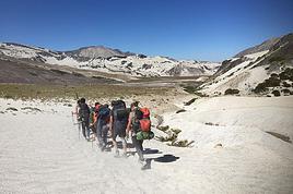
Pour la traversée El Chalten et Villa O'Higgins le sujet a été largement discuté sur ce forum, toutefois étant donné que je l'ai effectué au début du mois je me permets de remettre des informations de dernoère fraîcheur.
Si tu viens du sud (El Chalten) tu monte la vallée du Lago Desierto sur 40 km environ, la route est en mauvais état mais roulable toutefois.
Le Lago Desierto est un lac glaciaire de 12 km de long que l'on remonte a l'aide d'un bateau qui coûte 90 pesos (c'est cher pour 30 minutes de barcasse), le vélo voyage gratos. Ce bateau a des horaires un peu folcloriques mais circule tous les jours. Il existe un sentier pédestre le long du lac qui permet d'éviter de payer 90 pesos. Tous les gars que j'ai rencontré et qui l'ont fait m'ont dit qu'ils ne le feraient plus. Un allemand a même abandonné son vélo a mis parcours et est revenu le chercher avec le bateau des douanniers.
Côté nord du lago Desierto tu as la douanne argentine qui est sympa, ensuite tu as 6 km de marche en forêt. En gros, le premier km est merdique car le sentier est raide et trop étroit pour passer avec les sacoches, il est donc judicieux de retirer les sacoches d'un côté du vélo et de les fixer sur un sac a dos. Ensuite 3 km de marécages, ensuite 2 km en forêt où il faut un peu porter le vélo parfois. J'ai mis 2h30 en venant du nord.
Ensuite tu vois les panneaux de la frontière, il y a encore environ 20 km jusqu'au lago O'Higgins. Ces 20 km tu peux facilement pousser ton vélo ou même rouler avec parfois. Il y a un gué a franchir qui a un peu de courant car un pont a été détruit par la crue de la rivière, toutefois tu auras surement déjà les chaussures humides à cause des marécages, donc tu rentres dans la flotte en aval du pont détruit sans trop te poser de question.
Tu trouves la douanne Chilienne 500m avant le lac. Il y a possibilité de camper (signalé par un panneau) à 100m du lac sur un terrain qui appartient a un couple agé. Ils font également hostal et servent a manger.
Le bateau "Quertu" fait la traversée le mercredi et le samedi. Il part de Villa O'Higgins le matin vers les 8 heures, arrive à Candelario Mansillia vers 10 heures, repart pour faire un tour vers le glacier O'Higgins pour revenir vers les 15 heures à Candelario Mansillia et repartir vers Villa O'Higgins. Parfois le bateau a un peu de retard (vent, ...) Ce bateau circule depuis 2005 seulement et est organisé par un gars de Villa O'Higgins qui essaie de développer le tourisme dans ce bled. Tu paies 17500 pesos (chiliens) pour la traversée et 30000 pesos avec l'excursion au glacier. C'est également assez cher mais il y a deux heures de navigation et c'est vraiment un gros bateau qui est nécessaire.
Toutes les infos sur la traversée se trouvent ici: http://www.villaohiggins.cl/hielosur/index.htm
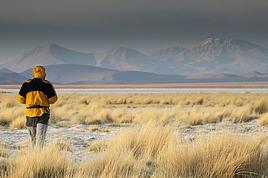
La Carretera australe est en relativement bon état près de Villa O'Higgins car le trafic y est moindre et la chaussée n'a pas été défoncée par les camions. Le paysage y est idylique...
Je trouve ton plan de voyage un peu chargé, je rentre de 7 semaines et je n'ai fait "que" Puerto-Montt - Punta Arenas. J'ai couvert 2500 km avec mon vélo et pense que c'était difficilement faisable en moins de temps. Naturellement j'ai également fait un peu de randonnée à pieds ( Fitz Roy, Torres del Paine) et fait quelques excursions hors de la Carretera ( Caleta Tortel, Los Exploradores, Chiloe, ...)
Je te souhaite un bon voyage dans cette région magnifique.
Christian
merci beaucoup pour ces reponses aussi rapides !! et tout particulierement à toi christian pour tous ces détails !! ça me donne encore plus envie !! c'est vrai que mon programme est peut etre un peu trop chargé. disons, que la partie retour : bolivie - buenos aires va surement etre réalisée en partie en bus je pense ...enfin on verra bien !! un voyage n'est jamais écrit à l'avance de toute façon ...
sinon d'ou es tu en suisse ? j'ai la double nationalité, j'ai de la famille à zurich et a pully ( lausanne ).
es tu encore en amerique du sud en ce moment ??
je suis de retour en Suisse depuis 3 jours. C'était mon premier voyage en amérique du sud mais c'est certain que je vais y retourner, en parlant un peu plus l'espagnol.
Je te contacte en privé pour plus de détails.
SALUT JEROME JE CROIS QUE TON PARCOUR EST REALISABLE EN TROIS MOIS J'AIS FAIS SAN MARTIN DE LOS ANDES USHUAIA EN 2 MOIS TRANQUILEMENT EN M'ARRETANT POUR RANDONER LE VELO NE POSE PAS DE PROBLEME DANS LE BUS MIEUX VAUT L'AMBALER ON TE DEMANDERA DE PAYER UNE MODIQUE SOMME.DEL CHALTEN A VILLA O HIGINS IL YA UN BATEAU 2 FOIS PAR SEMAINE POUR ATEINDRE LE LAC LE SENTIER EST DIFICILE TU POUSSERA BEAUCOUP LE VELO IL SUFIT DE PAS ETRE PRESSER.SI TU A BESOIN D'AUTRE RENSEGNEMENT VOISI MON MAIL:ZEITUN2000@HOTMAIL.FR
salut !!
je suis tombée sur ton message qui date un peu maintenant, alors j'espère que tu as bien fait ton voyage et que tu pourras répondre à mes questions!
je suis en train de préparer un voyage à vélo de 5 mois environ avec mon copain, nous pensons partir vers mi-février pour revenir fin juillet, et on cherche le meilleur compromis pour essayer d'aller en patagonie, côté chili et argentine et si possible un peu en bolivie et au pérou...alors ça fait beaucoup? as-tu fait ton trajet comme tu l'avais annoncé? ça me parait pas mal, et à priori pour l'instant on ferait quelque chose qui pourrait ressembler à ton projet : commencer d'abord le vélo d'ushuaia (en prenant le bus? pas trop long depuis buenos aires?) et remonter jusqu'à santiago : combien de temps faut-il prévoir pour ces environ 2400km? pas trop galère la traversée décrite par un autre membre du site entre el chalten et villa o'higgins? ensuite remonter en bus un peu, pour aller jusqu'à atacama ou même carrément atica pour être direct à la frontière chili/pérou, passer par le lac titicaca, et retourner en argentine et faire un crochet par les chutes iguazu avant de rentrer à buenos aires.
qu'en penses-tu???
merci d'avance pour tes réponses!!!
stéphanie
ah bah mince, pourtant tu avais l'air d'être bien préparé! dommage. mais si jamais tu as des infos ou si tu connais quelqu'un qui en a, n'hésite pas à me le faire savoir!
stéphanie
salut !!
tu as l'air de bien connaître l'amérique du sud!
je suis en train de préparer un voyage à vélo de 5 mois environ avec mon copain, nous pensons partir vers mi-février pour revenir fin juillet, et on cherche le meilleur compromis pour essayer d'aller en patagonie, côté chili et argentine et si possible un peu en bolivie et au pérou...alors ça fait beaucoup? à priori pour l'instant on ferait quelque chose qui pourrait ressembler à : commencer d'abord le vélo d'ushuaia (en prenant le bus? pas trop long depuis buenos aires?) et remonter jusqu'à santiago : combien de temps faut-il prévoir pour ces environ 2400km? pas trop galère la traversée entre el chalten et villa o'higgins? ensuite remonter en bus un peu, pour aller jusqu'à atacama ou même carrément atica pour être direct à la frontière chili/pérou, passer par le lac titicaca, et retourner en argentine et faire un crochet par les chutes iguazu avant de rentrer à buenos aires.
qu'en penses-tu???
merci d'avance pour tes réponses!!!
stéphanie
Savez vous si on peut mettre les vélos dans le bus entre Mendoza (argentine) et Santiago du Chili? J'aurais aimé appeler les compagnies directement mais sur le…
J pars dans 3 semaines au chili et je vais atterir à Santiago. Je voudrais pédaler de Chaiten à Villa O'Higgins, traverser la frontière pour El Chalten puis…
D'ici un mois je vais partir en Amérique du sud, en argentine plus précisément et j’atterrirais en avion à Buenos Aires. Je dois ensuite retrouver quelqu'un à…
Est il possible de mettre son vélo dans un bus entre Cusco et la frontière bolivienne? Laisser des affaires (dont un vélo) quelques jours dans un hotel à Cusco…
Je souhaite faire Morlaix Brest ( via Roscoff et la littoral V45) nous commencerons à rouler le 16 aout pour 13 jours (avec des pauses visites iles , surf etc..) Est ce qu'il y a beaucoup de circulation à cette époque de l'année car j'ai 2 enfants de11 et 13 ans et on n'aime pas rouler au milieu des voitures (on a déjà fait velomaritime ; Caen - Cherbourg, loire : Orléans- Saumur, Velodyssée : Nantes - Royans, les canaux : nivernais , bourgogne etc ... et il y avait beaucoup de voies réservées aux vélos ce qui n'est pas le cas sur cet itinéraire).
Merci de votre aide si vous avez déjà parcourue cet itinéraire fin aout.
Virginie
Ca y est j'ai mon billet d'avion, départ mi novembre, retour mi-mars.
arrivée santiago et je repars depuis Buenos Aires.
J'ai deja été dans le sud de l'argentine, notamment le parc torres del Paine, et j'ai très envie d'y retourner pour faire le grand W, j'avais fait le petit.
Je souhaite aussi randonner qq foois et pourquoi pas faire un sommet. Je grimpe et je fais occasionnellement de l'alpinisme, donc ce sera avec un guide de toute façon.
Je compte démarrer vers temuco au chili, j'ai dans l'idée d'aller vers les lac, puis prendre la careterra austral.
Je sais pas si je vais aller jusqu'à Ushuaia, parait que cela vaut pas tant que cela la peine, à part pour dire qu'on a été au bout de la terre.
j'ai vu vite fait qu'il y'avait des lac en Argentine.
Je n'ai pas d'itinéraire précis. Mais ce que je souhiaterai, c'est qu'une fois arriver le plus au sud de mon vooayage, faire une mini croisière pour voir des annimaux.
Des conseils pour cela?
qu'avez vous pris comme sac de couchage? un 0 degré suffit?
et ultime question, réchaud à essence ou est-ce que je peux m'en sortir avec mon réchaud gaz?
Cet été nous prévoyons de pédaler sur l'EV 19 qui longe la Meuse de Langres jusqu'à Rotterdam.
Mon questionnement concerne le retour jusqu'à Nantes.
Savez vous quel est le meilleur retour possible? J'en appelle à vos expériences.
Je voyais que Flixbus ne prenait pas les vélos.
En train, je pense que c'est possible avec de multiples petits trains.
On se questionnait aussi sur l'existence d'un bateau qui irait de Rotterdam jusqu'à St Nazaire et qui pourrait charger des passagers avec vélos.
Toutes vos expériences partagées nous seront bien utiles et nous vous en remercions.
Bonne soirée
Hi there,
I’ve been road cycling for several years, and I’m about to switch to gravel in the next few days—I’m waiting for my bike, which should arrive this week.
I’m planning a bikepacking trip in a few weeks along the Véloroute V81, also known as the Vélosud, from Biarritz to Le Barcarès.
Has anyone here already done this route? Any info is welcome, whether it’s about the route itself, gear, or accommodation. I’ll prioritize staying with locals as much as possible. On that note, I just signed up for the brand-new site *Guidon et Couette* ((www.guidon-et-couette.fr)), which offers free accommodation between cyclists across the country, but there’s almost no one listed along my route!
Thanks in advance.
Laurent.
I’m planning to build a new touring bike.
I want to prioritize lightness.
That said, I’m tempted by a suspension fork that could offer some comfort on rougher roads.
The recent appearance of gravel suspension forks on the market might meet my needs—at least on paper.
I’m particularly considering the RockShox Rudy Ultimate XPLR fork.
Unlike MTB forks, its travel is short: either 30 mm or 40 mm.
It weighs 1400 g, which is 400/500 g more than a steel fork.
Any thoughts or real-world feedback on this?
I’m also wondering about the durability of magnesium (lower leg) for long-distance bike touring.
And what’s the impact of skipping the manufacturer-recommended maintenance every 50 and 200 hours? That’s bound to happen on a long trip unless you carry extra gear.
More generally, how reliable are these kinds of forks?
Hi everyone,
I wanted to share with you the incredible feat my friend José, who’s 72 years old, is currently undertaking. He left Auterive near Toulouse on Monday, May 18, 2026, on his non-electric bike, heading for the North Cape in Norway!
You can follow his route on the link below—he’s currently in Sweden:
https://thierry-thomas.travelmap.net/jose-de-toulouse-a-nord-cap-2026
You can zoom in on the map and click on each stopover town to see the photos
I’m making an exception and creating a separate post this time, since it’s all about France. In May, we spent a week in Provence, specifically in the Luberon, exploring the cycling routes *Autour du Luberon à Vélo*, the *Véloroute du Calavon* (part of EuroVelo 8), and the shorter *Les Ocres à Vélo* route. Together, they gave us an amazing journey through rolling hills, vineyards, lavender fields still green in spring, and some of the most stunning landscapes in southern France.
It was, of course, the perched villages that impressed us the most. We visited Gordes, Roussillon, Bonnieux, Lacoste, Lourmarin, Ménerbes, Oppède-le-Vieux, Cucuron, and Lauris. Many of them are among the most beautiful villages in Provence, and it’s hard not to agree with that reputation.
One interesting point is the route of EuroVelo 8 in this part of the region. The official path mainly follows the old railway line of the *Véloroute du Calavon*, which is very comfortable and safe. But in our opinion, cyclists traveling EuroVelo 8 around the Mediterranean would discover even more treasures if the route passed through villages like Bonnieux, Lacoste, or Oppède-le-Vieux.
We were also pleasantly surprised by how safe cycling felt. Most of the route takes small local roads, but traffic is light, drivers are respectful, and road design really takes cyclists into account. It’s one of those places where you can ride peacefully even without separated bike lanes.
Our full story:
Around Luberon by bicycle - the most beautiful villages of Provence
You can also find all our cycling travel stories on the forum:
Cycling Thread - Europe’s most beautiful bike routes
Hi there, we’re a group of 4 cyclists looking to get from Treviso in Italy to Munich with our 4 non-folding bikes. It seems complicated! Are there any solutions? Thanks so much.
hello fellow cycling enthusiasts
here’s a travel journal of the cycling tour through the Rhône-Alpes Auvergne region by Claudio
zouli
it was the plan
http://cbandiera.free.fr/parcours/auvergne-Ralpes/
the trip was completed
story being posted online soon
1100 km in 11 days
beautiful and varied regions
Hi there, we’re planning a Munich to Venice bike trip at the end of June 2026. Getting back from Venice to Toulouse by train with 4 bikes isn’t straightforward. What return options have others who’ve done this trip chosen? Any tips or great deals would be much appreciated. Thanks a bunch! !
Hi everyone,
Happy owner of a Pegasus Estremo bike with a Rohloff hub, which is giving me trouble with the SF11-NCX-FT-E-LITE 700C TS 300/0 fork (serial number TD01329060). It’s starting to show its age, and I’d like to repair it to extend the life of my beloved bike.
The suspension is gone, and there’s an oil leak from the seals.
Does anyone know how to repair it? Where can I find parts that are about fifteen years old? Or where to find an identical replacement fork? Just to clarify, the Magura HS11 brakes are mounted using Firm Tech, meaning they’re on pivots behind the fork, facing the frame.
Hi, I'd like to know if anyone has done this route recently or has reliable info.
Does the track exist, and most importantly, is there sand (for biking)?
Any info is welcome.
Cheers,
diego ambilobe: mangaoka, manondro, ramena
vohemar sambava: masondrono, tanambao
Hi there,
New to bike touring,
I’d love to start with a section of the Via Rhona to explore and share (route to be decided).
Looking forward to exchanging tips!
I’m landing in Madagascar with a buddy before the end of April 2026. We’re planning to bike around for about twenty days or so. We don’t have a specific goal other than exploring the country and meeting the locals.
Ideally, we’d prefer a loop route starting from Antananarivo with a good chunk of it along the coast. On the bike side, we’re used to riding 6 to 8 hours a day, depending on the needs, encounters, and mood 😉 Any feedback or tips from trips around this length?
A big thank you to Lazarou for all the info you share in this forum!
I'm passionate about Morocco, which I cycled through back in 2009.
Last year, my wife and I explored the High Atlas by tandem. Completely smitten, we're heading back in April (Anti Atlas) and May (High and Middle Atlas), still on our tandem.
Do you have any info on the track between Amezri and Ali Ait Nito? Are the river crossings in the Tessaout still there? It's not easy to navigate with a loaded tandem... especially if the river level is high due to this year's heavy snowmelt!
Thanks in advance for any tips you might have, and best wishes for health in this new year!
Claudio specializes in the route of the Savoie lakes
Here are his travels
Between Bornes, Chartreuse, the Savoie foothills, and Dauphiné
Five lakes: Léman, Annecy, Paladru, Aiguebelette, Bourget, not to mention a few ponds along the way
Plenty of accommodation options: camping, hotels, and more...
A lovely route not far from his place
Rural and quite peaceful
A road cycling route created by Serge B...
Tout d'abord... bonne année ! De belles routes à vous en 2017 !
Je voyage depuis quelques années avec un VTT de très bonne qualité mais équipé de freins à disques hydrauliques. Je vis (pédale) avec l'inquiétude d'avoir une panne (fuite, bulle d'air, chaleur qui fait que le liquide...). Mon vélociste me dit qu'il est impossible de les changer pour des V brakes.
Qu'en pensez-vous ? Est-ce que je prends un gros risque à continuer (seule) avec ces freins ? D'avance je vous remercie pour vos bonnes idées.
First post here to share a quick recap of our west-to-east bike trip along Algeria’s coast in January 2025.
It was just the two of us—my partner and I—with French passports and not a word of Arabic. No friends or welcoming hosts in the country.
Under those conditions, we’d strongly advise against going.
Our original plan was to follow the coast from Algiers to Tunis. We ended up cycling from Algiers to Béjaia, then took the train from Béjaia to Annaba (with a stop in Constantine), and finally biked to the border.
We were tailed by police the whole way—whether on our bikes, on the train, or even on foot while exploring towns. On top of that, we couldn’t wild camp and were limited to the few state-approved hotels that accept foreigners. Under those circumstances, connecting with locals was especially tough.
With such an omnipresent and intrusive police presence, we’d definitely recommend against this destination for bike touring. A really sad situation that completely cuts you off from the local population...
We’d been warned, we went to check it out, and we weren’t disappointed!
Hi there,
I’m planning the route to cycle from Lille to Nordkapp with my partner.
Duration: 3 months, from May 1st to July 31st, 2026.
In the attached details below, I need to add some "non-riding" days (rest days, basically).
So I’m looking to "shorten" the trip by taking ferries or trains for some stretches. Which areas could I skip?
Thanks in advance for your great tips.
Have a good evening.
https://www.komoot.com/fr-fr/collection/4023980/-lille-cap-nord-1er-mai-au-31-juillet-2026?ref=collection
I’m planning to bike back from Poland this summer. Does anyone know a way to ship it there without having to take it apart? Otherwise, it’s a real hassle to fine-tune all the settings before departure!
Thanks in advance.
Hi, has anyone recently bought Primus or Butagaz gas, possibly puncture-style, in Dubrovnik or the surrounding area? Same question for Albania... thanks. aichatou
Just a few words about the loop I did by bike in Yunnan.
Entry and exit
I entered China through the Sino-Vietnamese border crossing at Lào Cai / Hekou under the 30-day visa exemption currently available to French nationals and others.
The process was simple and quick. A Chinese police officer even helped me complete my electronic pre-registration at a computer kiosk. I wasn’t aware this formality was required—it’s similar to Thailand’s TM6.
No issues with the bike.
I left the country via the Sino-Laotian border crossing at Mohan / Boten.
The atmosphere was a bit chaotic there, but again, no problems with the bike.
The timing
I visited Yunnan in February 2026.
Weather-wise, at higher altitudes (between 1,500 and 2,000 meters), it was around ten degrees at night and in the mornings, and around twenty degrees at the hottest part of the day.
I had two days of rain, so I took the bus to keep moving. Otherwise, clear blue skies.
Culturally, Chinese New Year fell on February 17th (and the 15 days following), right in the middle of my trip. Because of this, my take on the traffic might be off.
Accommodation and food
I always found a hotel to stay in for prices ranging from 8 to 15 €. Except in Kunming (the capital), where many hotels were fully booked (Chinese New Year). I ended up at a 100 € hotel with great value for money.
A bowl of noodles costs about 1.5 € on average.
Onboard electronics
Since my smartphone doesn’t support eSIMs, I subscribed to a China plan with my carrier. Otherwise, for much cheaper, Alipay offers eSIMs for foreigners that allow access to services usually blocked for Chinese users (WhatsApp, Facebook, etc.).
An internet connection is essential for paying with Alipay or WeChat, as this payment method is widespread.
I only managed to use Alipay.
Either way, always carry cash because sometimes there’s no signal, or the merchant only accepts WeChat.
Also, it’s best to bring a power adapter when you arrive rather than struggling to find one.
Traffic and roads
The Chinese aren’t reckless drivers. They follow traffic rules and watch out for cyclists. This is slightly less true in Xishuangbanna (the region bordering Myanmar and Laos).
In urban areas, there are almost always wide bike lanes, separated from other roads, where bikes, electric mini-scooters, and scooters share the space pretty harmoniously.
The roads are in great condition, and traffic is generally manageable—even light—except for one stretch (Eshan -> Yangwu).
Most traffic is absorbed by expressways, China’s equivalent of highways: toll roads that are off-limits to slow vehicles.
You’re never far from these expressways; sometimes you even ride alongside them, which can be noisy at times.
The climbs are usually reasonable, around 5% to 6%. From what I remember, the steepest section was between Menglun and Mengla, with gradients of 8% to 10%, sometimes more.
Riding at these altitudes—though modest—took a bit of getting used to.
The route
I didn’t plan anything in advance. My only goal was to reach Kunming. I don’t know why, but just hearing the name of that city, like Yunnan, always felt dreamy to me.
Hi! I’m planning to visit the Stockholm Archipelago by bike in early April.
Do you know if the boats will be running between the different islands at that time of year? For those who’ve already been, all your tips and recommendations are welcome—accommodation, etc. Also, do you know where I can rent a bike in Stockholm? Thanks so much in advance for your help!
Hello there, pedal-powered Young Boys!
Claudio (still from Faverges)
dreaming about a cycling getaway in Italy from Faverges (train all the way to Turin)
from Turin down to Venice along the Po River and back via the Padana (Alta Italia da attraversare – Northern Italy to cross)
The tricky part is getting from Chioggia to Venice.
I read it’s possible by hopping on a boat from island to island,
but it sounds a bit stressful.
Has anyone already tackled this route?
I’m currently looking for a bike to do my first bike trip across France, with the ultimate goal of cycling through Latin America. I’ve got a lot of questions and I’d love to hear if you have any answers or advice to share.
First off, I’ve been through this before with hiking. I want to get top-quality gear right away. When I started hiking, I ended up buying everything three times—first beginner gear, then intermediate, then expert, etc.
For biking, I’d prefer to skip that process and invest right now in a bike that could ideally handle Latin America.
I’ve set a total max budget of around 5000 € (roughly 4000–4500 € for the bike and the rest for accessories: panniers, helmet, cycling shorts, etc.).
So, I’ve got quite a few questions:
* I’ve read in several places that some people recommend buying the bike directly in Latin America. Since I need a first bike to train in Europe, would it be better to buy an entry-level bike in France (and sell it before the big departure)? Or is it preferable to start right away with my final bike to get used to it? Is buying it there just to save a bit of money?
* For a long-term trip (around six months) in Latin America, is it better to go for a gravel bike or a mountain bike?
* Should I buy a new bike or a refurbished one? Even more so given that I’m planning a long trip—could a refurbished bike end up causing more breakdowns?
If you have any advice on models, technical features to prioritize, or recommended sellers or resellers, I’d love to hear it. I’m a total beginner—I’ve only just started watching videos and reading up on the subject, and all the technical specs are new to me!
Calling all travelers.
We’ll be landing at Lyon Airport and want to bike to La Verpillière train station (with panniers and camping gear, etc.) to catch a TER to Voreppe.
What’s the safest route for this bike trip?
Thanks in advance
hi,
I'm planning a recumbent bike trip from the Pyrenees to Greece. On the EuroVelo 8 route, it doesn't specify the path through the Alps.
Are there any experienced cyclists here who can tell me where they go to avoid climbing too high?
Also, is there another traveler/bike forum better suited for broadening the responses?
thanks