Bonjour à tous et toutes , je viens sur ce forum pour vous demander conseil.
Mon amie et moi avons ce rêve de parcourir les Etats-Unis, peu à peu, et nous voulons commencer l'été 2015 pour une période d'un mois.
Nous voulons arriver à Washington, et partir jusque New-York, en passant par Philadelphia. Tout ceci à pied ( 75heures l'aller) ou en stop, et nous tenons vraiment à le faire de cette façon, c'est ça le but de nos "escapades".
Mes questions sont les suivantes :
- Quelqu'un ici l'a déjà fait?
- En un mois est-ce faisable ?
- Y'a t-il des refuges sur cette route ?
Et pour finir, nous cherchons un compagnon masculin, parce que deux filles seules sur la route .... puis ça nous fera une bonne petite compagnie !
Je ne suis pas certaine que ça soit le plus agréable voyage! Si vous voulez decouvrir un peu la région autour de New York, il faut mieux remonter vers le nord, vous aurez l'occasion d'y voir plus de choses. Mais c'est juste mon humble avis. Si vous voulez le faire, ca doit etre faisable en un mois effectivement car il y a un peu moins de 400 kilomètres. Par contre, je ne sais pas ce que vous voulez dire par refuge. Bonne balade en tout cas!
Vous avez besoin d'autres informations sur New York? Elles sont surement sur mon site: http://sejour-newyork.fr, sinon, n’hésitez pas a me demander.
Sans doute, quelqu'un l'a fait--il y a 200 ans. Aujourd'hui, entre NY et Philly tu verras une melange de rafineries, usines chimiques, Superfund sites, et autoroutes. Joli, hein? Refuges? New Jersey Turnpike rest stops! (je plaisante). New Jersey est l'etat avec la plus elevee densite de population parmi les 50 etats americains.
Si tu veux vraiment aller de NY a DC a pied, je conseille l'Appalachian Trail, une tres belle piste dans la foret aux montagnes qui va du Maine vers Georgia. Tu peux prendre un train vers une ville au nord de NYC ou le Trail traverse la riviere Hudson, et puis descendre jusqu'a Harpers Ferry (West Virginia). De Harpers Ferry, on peut suivre le Chesapeake & Ohio Canal a pied jusqu'a Washington, ou bien prendre le train MARC chaque matin. Et oui, on trouve des refuges au bord de l'Appalachian Trail.
Bonjour,
Tu es une troll?
Aujourd'hui, entre NY et Philly tu verras une melange de rafineries, usines chimiques, Superfund sites, et autoroutes.
salut en France les gens ne connaissent pas du tout les réalités des USA, ils s'imaginent des tas de choses..
or comme tu le mentionnes si bien la partie Est des USA c'est un étalement urbain sans précédent avec des zones "exo-urbaines" à l'infini. 😐
C'est pas comme en France où on arrive toujours à trouver un GR même en étant en région parisienne ( on peut aller en forêt de Rambouillet ou Orléans)...quoique la France c'est pareil il y a de plus en plus de centres commerciaux et zones d'activité à droite et à gauche
C'est pour ça que j'ai été très déçu par la Floride , ça va devenir du nord au sud , de Jacksonville à Miami une giga zone pavillonaire avec des rues en quadrillage, des turnpikes, des highways bref une grosse horreur.
Parenthèse fermée, tout n'est pas perdu pour autant car comme tu le mentionnes très bien l'attrait de l'état de NY c'est la chaîne des Adirondacks assez isolée qui en fait un parc national et effectivement l'Appalachian Trail qui me semble-t-il part du Canada aussi.
Nous voulons arriver à Washington, et partir jusque New-York, en passant par Philadelphia. Tout ceci à pied ( 75heures l'aller) ou en stop, et nous tenons vraiment à le faire de cette façon, c'est ça le but de nos "escapades".
comme mon prédecesseur : est-ce un message sérieux ?
La géographie aux USA ça n'a rien du tout à voir avec la France
Pour randonner il faut aller dans les parcs nationaux
La géographie aux USA ça n'a rien du tout à voir avec la France
Pour randonner il faut aller dans les parcs nationaux
C'est vrai que la geographie aux USA n'a rien du tout a voir avec la France, mais il ne faut pas aller dans les parcs nationaux afin de trouver de belles randonnees. L'Appalachian Trail est vraiment superbe, meme la partie dans le nord-ouest de New Jersey. On peut aller aussi de Washington, DC a Pittsburgh en suivant le C&O Canal jusqu'a Cumberland (Maryland), et puis le Great Allegheny Passage (GAP) Trail de Cumberland a Pittsburgh qui suit un ancien chemin de fer. Cette route (DC<->Pittsburgh) se fait a velo aussi.
Si tu aimes la ''grande nature'' préservée on ne saurait te dire mieux que de suivre l'avis de Aquilegia : la Appalachian trail, internationalement connue, qui court sur bien plus long que ton trajet , plusieurs milliers de kilomètres entre l'Alabama (de mémoire) et maintenant poursuivie au Canada jusqu'à la pointe de la Gaspésie (de mémoire)
Et maintenant en prime on y rencontre plein d'ours noirs dont la population a spectaculairement grimpé ces dernières décennies sur la côte Est notamment
mais si tu préfères les paysages plus variés, tantôt urbains, aménagés, marqués par l'histoire de ses habitants, tantôt ruraux, bucoliques, tantôt agricoles,
…. il y a, à travers tout le pays, une multitude de possibilités offertes par le programme Rails-to-Trails qui comme son nom l'indique consiste en un réseau d'anciennes voies de chemin de fer régionales ou locales plus ou moins aménagées en '' sentiers'' de randonnée de toutes les longueurs. Souvent de quelques kilomètres à quelques dizaines mais certaines de plusieurs centaines .
L'alternative à l'Appalachian Trail proposée par Aquilegia, via Cumberland, me semble d'ailleurs appartenir à ce réseau d'anciennes voies ferrés
On peut s'en servir pour se construire, avec une bonne carte, une partie plus ou moins importante de son itinéraire dans à peu près n'importe quelle région .
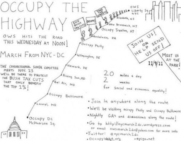
à moins que ..... vous vouliez rééditez, en sens inverse, la fameuse marche de ''Occupy Wall Street'' dont la presse internationale parlait en 2011😛
dans ce cas c'est ici :
Occupy Wall Street protesters arrive in D.C. after 231-mile walk from
Suite des "Rencontres insolites avec des grizzlys, chercheurs d'or et autres dans l'Ouest Américain" (26 février 2009)
Non , absolument pas , nul besoin d aller dans les parcs nationaux pour faire de belles randonnees....
mon message a mal été compris évidemment on peut randonner ailleurs que dans les parcs nationaux...
mais je connais assez bien le Canada, qui est un clone des USA et j'ai été déçu , lorsqu'on trouve quelques sentiers il y a forcément des bagnoles qui passent , c'est l'omniprésence de la bagnole donc pour les soi-disant grands espaces de l'Amérique du Nord on repassera..je préfère aller en Asie Centrale, Amérique latine ou ailleurs.
Ceci dit les gens font ce qu'ils veulent..
Viens ici quand tu veux on peut faire des randonnees au milieu de nulle part pendant des mois si l on veut et ce sans voir une seule bagnole ....tu connais tres mal ( voir pas du tout les possibiltes de randonnees aux Usa )
Non , absolument pas , nul besoin d aller dans les parcs nationaux pour faire de belles randonnees....
mon message a mal été compris évidemment on peut randonner ailleurs que dans les parcs nationaux...
mais je connais assez bien le Canada, qui est un clone des USA et j'ai été déçu , lorsqu'on trouve quelques sentiers il y a forcément des bagnoles qui passent , c'est l'omniprésence de la bagnole donc pour les soi-disant grands espaces de l'Amérique du Nord on repassera..je préfère aller en Asie Centrale, Amérique latine ou ailleurs.
Ceci dit les gens font ce qu'ils veulent..
C'est tout à fait ridicule. Est-ce que t'as jamais visité les USA?
J'ai réservé depuis plusieurs mois un tour avec Monument Valley Safari pour le 02.08.2020 malheureusement mon vol est annulé et je ne pourrai donc pas faire ce…
Tout est dans le titre, j'aimerais savoir si quelqu'un connait et a déjà fait cette rando juste à l'entrée de Zion. Si oui, où doit-on commencer et où…
Nous partons en septembre pour un mois aux US, Arizona, Utah, Californie et cette fois j'aimerai avoir avec nous un GPS de randonnée, en effet certaines randos…
La question est dans le titre: quels sont vos plus beaux slot canyons? Ce post est purement occupationnel, mon corps est emprisonné mais ma tête voyage... Si…
Bonjour,
Nous souhaitons faire le trek de 4 jours reliant Mestia à Ushguli sans agence. Il est précisé dans les descriptifs qu'il existe des hébergement à chaque étape, mais on ne trouve pas d'info sur ces hébergements. Quelqu'un a-t-il des infos et un avis sur ce parcours?
We're planning to trek in Peru and Bolivia and would love to find some local agencies.
If you know any, could you share details on prices and, of course, the names of the agencies?
Which trek would you recommend?
Elocine
Je pars en autonomie totale sur un trek au Maroc (10jrs) Imilchil - Aghbalou.
Trouve t-on des cartouches gaz à vis (Coleman, Primus) à Marrakech (adresse) ou villages entre Imilchil - Aghbalou ?
Si non , trouve-t-on des cartouches Butagaz pour camping-gaz (petit volume 230 gr ...)
Merci d' avance pour vos réponses
Hello, I’d like to embark on a little trip in my home country, Switzerland. I’ll start walking from La Cure, heading toward Le Noirmont first, then I’ll improvise my route—but it’ll probably follow the French border... at least as far as Lac de Joux.
I’ll decide day by day how much farther to go after that. My goal is to stay in nature as much as possible, wander around for as long as I can, and restock food in villages or towns along the way.
I’m thinking of mostly camping, but we’ll see if I end up in a hotel or another campsite depending on my route.
I’d love to reach La Chaux-de-Fonds on foot... maybe even Delémont.
The whole thing should take about a week, give or take.
I’ll be bringing my dog, and I’m preparing for this as soon as I’m ready.
Any tips to make sure everything goes smoothly for us? Things I should know—or avoid? What about shepherds with their flocks of sheep? And isn’t hunting season open right now?
I’m not sure if what I’m planning is even doable, which is why I’m asking around.
This’ll be my first time doing something like this—wandering in nature *and* with a dog. I’m really excited for this adventure... and I need it. Thanks!
We’re really keen on ecosystems and want to hike in "natural" ancient forests—not planted woods or areas heavily degraded by human activity. Travel guides (like Lonely Planet) don’t provide much info on this. Could you point us to the most interesting spots?
Thanks in advance for your tips.
We wish you happy holidays and a fantastic 2026, full of discoveries!
Claire and Albert
Hi, this might not be the right section, but I’d like to know if it’s possible to start mountaineering with another person without necessarily hiring a guide. We’ve done quite a bit of hiking but not mountaineering—we’ll just do a half-day glacier course. After that, we were thinking of starting with La Grande Motte and the Pointe de la Traversière, which were recommended to us. Honestly, for things like roping up and knots, I’ll learn at home with lots of videos and a book.
Hi,
I don’t know Switzerland at all and was wondering if Vallée des Joux and especially Dent de Vaulion are packed early in the morning or late in the afternoon in July and September?
If so, do you have any quieter spots to recommend in the area, or in Luxembourg (yes, I know it’s not the same country 😉)?
Thanks a lot!
I’m starting this thread—lots of travelers here have done this trek.
When RMS is mentioned, it’s this agency: Ruwenzori Mountaineering Services (with an *s*), because there’s another one online called Ruwenzori Mountaineering Service (no *s*).
Their site:
www.rwenzorimountaineeringservices.com/
From what I gather, it’s the local mountain guide agency certified by the government?
Jaimerais savoir si quelqu'un aurait fait des treks sur le Ruwenzori et combien ça coute en moyenne, les infrastructures, les paysages la sécurité sur les lieux, merci beaucoup. J'attends avec impatience vos réponses.
We’re leaving in 9 days for a two-week trip to Madeira, mainly to hike.
From my research, I’ve found that since last year, access to most trails—and systematically for the most popular ones—is now paid. You have to pay an access fee of 4.50 € per person per classified hike in 2026, and even 10.50 € for the most iconic hike: Pico Arieiro to Pico Ruivo. When paying, you also have to choose a day and a 30-minute time slot for your start time. Of course, this reservation is neither changeable nor refundable, even if the weather that day is terrible.
Personally, given the massive influx of tourists to the island in recent years, I don’t mind paying a fee to help maintain the trails. Similarly, setting a limit on the number of people who can hike them per day is certainly preferable to preserve this priceless heritage.
However, what’s much less fair is that in reality, most of the available spots are reserved: 1/ for Madeira residents (which is normal); 2/ for "economic operators" (meaning local tour operators). For example, if you’re a non-resident (independent tourist), no booking is possible for the Pico Arieiro hike for an early morning start before September! So, unfortunately, we’ll have to skip this hike.
It’s the same issue for Ponta de São Lourenço, the 25 Fontes, Pico Ruivo... in short, all the most popular hikes. Oh well, we’ll skip those too!
So my question is: which hikes do you recommend where we won’t face the huge crowds that the others get? And where we can book the day before for the next day, taking the weather into account?
Finally, a quick accommodation question: we’ve booked the first week in Funchal, but I haven’t decided yet for the second week. Do you have any advice on where to stay in the south or north, preferably avoiding overly concrete-heavy and touristy spots?
I’m reposting about the logistics for Samaria Gorge.
I’d love to get recent info, especially about whether it’s possible to park my car in Omalos, do the hike, and then catch a bus back to my vehicle.
In theory, it’s doable, but when you check the KTEL website, there aren’t any feasible schedules listed. If anyone has recently organized this with reliable, verified details, I’d really appreciate it. Thanks in advance!
Hi there,
We’re flying from Montreal to Lyon this August to go hiking in the French Alps. We’ve rented a car and will be staying at campgrounds. We’re planning to do day hikes and want to stay a few days in one spot, do a few hikes, then move on to our next camping spot. Could you share your favorite spots or any recommendations for places to spend a few days with great hikes?
A few details:
We arrive in early August and leave in early September.
We’re looking for day hikes (or shorter), moderate difficulty, with a cumulative elevation gain of no more than 1000m, and of course, beautiful scenery!
We’d prefer not to drive too much—maybe it’s best not to head too far south and deal with unnecessary heat?
Along the same lines, if you know of any great campgrounds where we can start our hike directly without needing the car, we’d love to hear your suggestions!
Bonjour
Souhaitant faire de la randonnée sur cette île, je voudrais d'abord savoir quelle serait la période la plus favorable sachant que j'avais passé quelques jours en novembre 2018 pas pour cette activité mais plus pour une simple découverte de l'île et le temps n'était pas top notamment en montagne. Donc peut on choisir une organisation en étoile sachant que je louerai un véhicule avec éventuellement 2 points d'hébergement.
Je n'envisage pas d'intégrer une structure mais de partir à 2 et de s'organiser sauf si vous me conseillez une agence locale ou un guide local. Enfin même si je compte me procurer les différents supports, carte et topo guide plus gps je vous remercie de bien vouloir me communiquer les randos à faire en priorité
Merci beaucoup pour vos informations
I’m planning to do the Mercantour crossing following the Randoxygène route in mid-July.
I’m used to hiking in the mountains, but I sometimes get vertigo, for example on ridges with drops on both sides. I wanted to check if there are any T4 or T3-T4 sections and find out if there are any very exposed passages—and if so, where—so I can plan an alternative route.
Can anyone give me some info on this?
Thanks!
I’m planning a trip around Cap Corse and the AGRIATES in 2026, from May 8th to 15th (there are still 2 spots left, by the way! Just DM me if you're interested).
I’d love to know which hikes are worth prioritizing in the AGRIATES. We’ll be staying in SALECCIA for two days as our base—what should we focus on from there?
A round trip to IGNHU beach? Any other suggestions?
For Ostricano, I think it’s too far for a round trip...
Thanks for your tips!
Have a great day,
Anie, Toulouse
I’d like to get some info about the GR10 Pyrenees traverse. I need help planning the daily stages and accommodations—my wife isn’t an experienced hiker but walks a lot, so I’d like to schedule shorter walking days and thus a longer overall trip in terms of number of days.
Could anyone give me some help and advice?
Best regards,
New to this forum, I’m planning a pretty big project for 2028.
I’m heading to Nepal to do a trek from Kathmandu all the way to Everest Base Camp (a cool 5,300 m 😄).
This trek is a bit special because even though I’ll be part of a group, I’m going solo (so far, no problem—I’m used to it). But it’s my first real trek, and it’s also a humanitarian one: once I reach base camp, I’ll stay an extra week to help clean up the waste left by tens of thousands of climbers! Since I’m originally from South America, from two countries that share the Andes, I have a deep respect for mountains—they fascinate me. So Everest… it’s kind of the trip of a lifetime!
So, a little question for those who’ve done treks to Everest before… any tips for good mental preparation (I’m already working on the physical side)?
Hi there, I’m planning the Annapurna Circuit for March 2027 and I’m looking for a local agency with a local guide—preferably French-speaking—to arrange this trek for us. Any suggestions? Thanks
Hello!
We’re spending a few days in Toraja country at the end of May. We’d love to do a day trek—taking our time—on a route that’s stunning in terms of scenery, but not a level 5 in difficulty!
Any suggestions you can share, please?
Thanks in advance
I’d like to do the Mare a Mare Sud in May over 4 days. I’ve found quite a few places to stay along the route, but I’m stuck on the start and finish.
I’ll be arriving by plane on Sunday evening and would like to start pretty early on Monday morning. Ideally, accommodation right at the trailhead (Alzu di Gallina) would be amazing, but I can’t find anything. Any tips?
Also, for the transfer from Figari Airport to Porto Vecchio or Alzu di Gallina?
At the end, I’d like to pick up a rental car—any advice on that too?
I’m traveling solo by plane to Catania in May and plan to hike the northern side of Etna, starting from Linguaglossa where I’ll arrive by bus. After that, I’d love some info on how to get up to Piano Provenzana (shuttles or hitchhiking), since it seems there’s no public transport except in the summer. Can you sleep there in a free or cheap refuge, or camp? And how far up can you go without having to hire a guide? Thanks in advance. Bernard.
Bonjour a tous,
je pars en voyage au Maroc en aout et nous allons commencer par nous arrêter a Chefchaouen(nous sommes en voiture).
Ma question: quelqu'un peut il m'indiquer un itinéraire de rando en boucle d'entre 5 et 7 jours aux départ de Chefchaouen dans le parc de Talassemtane passant si possible par le pont de dieux?Ou un guide papier qui en reunis quelques uns?
Nous privilégions le camping sauvage et les gites.
Merci d'avance
Hi there, for those who’ve been recently—is it possible to find other solo travelers in March on the island to share transport or room costs? It doesn’t seem easy to travel on a budget.
If you have any recommendations for simple lodgings or places with dorms, I’d love to hear them.
For those who’ve done multi-day treks while moving around: do you need to bring your own sleeping bag? I’d love to hear about itineraries you’ve done without a guide, just with a map and GPS.
Thanks, and have a great day!
Hi everyone!
We’re planning a 15-day road trip to Scotland this summer, specifically to explore and hike on Lewis and Harris—places we’ve never been before. We’ve visited other islands on previous road trips in Scotland (we usually go in April for a week). This would be our first time in Scotland in the summer and for 15 days. We’re looking at late August to early September.
I’m currently drafting the itinerary. We’d be crossing from Ullapool and were thinking of spending 3 nights on Harris and 4 nights on Lewis.
Does that sound balanced to you? Is it better to keep the same accommodation on Harris and the same on Lewis to explore the area? I’d love to hear about any past experiences you’ve had on these islands.
Thanks!
Hi there, I’m trying to leave for 15 days very soon to São Vicente. I’m either looking to join an agency or figure things out on my own to go hiking on one of these islands or both. From what I’ve seen, it’s not easy to organize with local transport, so it gets expensive. Can I use the services of a small local agency? I’m looking for the simplest way to hike for several days. Also, how do you get from São Vicente to São Nicolau? Thanks in advance and have a great day!
Aichatou
I’ve been wanting to do this for several years, and this year’s the one. Next September, I’ll be trekking in Tusheti (Georgia), from Omalo to Shatili.
Of course, I won’t be renting a vehicle that’d just sit unused. No problem getting to Pshaveli, but from there to Omalo, it’s a dirt road (still the case?)
There must be some form of public transport since there are so many guesthouses, and not all travelers come in a 4x4.
If any of you have been to Omalo, could you confirm that these shared transports exist and how often they run?
we’re planning a trip to Yellowstone and hoping to do a three-day backcountry hike if we get a permit.
if any of you have done this before, could you let me know if it’s possible to find water along the way? And if we can transport it, are we allowed to use a stove?