Je finis la descente du mekong côté thailandais et après je passe au laos et j'aimerais aller de Champassak à Don khong par le chemin le plus près du Mekong et savoir si en route je trouverais pour me ravitailler et me loger, je suis à vélo
Je ne veux pas prendre l'axe principal qui va de Pakse à la frontière du Cambodge car je connais , c'est plat et droit, , inintéressant à vélo
J'attends des informations seulement de personnes qui ont effectué ce parcours, pas de on m'a dit que...
Merci d'avance
Nous avons fait Don Khong -Pakse par le rive Ouest du Mekong. 4 jours de paradis. Les plus 300km de notre périple.
Voici les photos : http://2hobosinasia.blogspot.sg/2013/02/8-9-en-10.html?view=timeslide
Le texte est en néerlandais, mais avec le traducteur de google vous allez pouvoir récupérer qq info pratique.
Merci pour tes infos
Je viens d'arriver il y a 3 heures à don khong
J'avais eu les infos à pakse par un laotien qui m'avait tout traduit en français et laotien sur un papier
Mais c'est vrai que c'est simple de soukoumak à saphang par la piste qui longe le mekong en passant par bugkeo
C'est une piste roulante et pas sablonneuse et comme il y a un pont de don san à don khong cela donne un parcours vraiment sympa je suis parti il y a 3 semaines de chiang kong au nord de la thailande, mais cette étape aujourd hui etait une des plus belles avec la montée de fuchi fa au nord est de la thailande , en début de voyage
Bonne route à toi
Pas Dong Khong, c'est moche et rien à y voir ! Allez plutôt dans un petit paradis, Don Khone. Voici mes notes de voyage à ce sujet :
l’ile de Don Khone ; j’avais prévu 2 jours, il a fallu me torturer pour la quitter au bout de 6. Un petit village principal d’une rue en terre, un tas de GH et bons restos, et un tas de belles choses à voir.
Pour le logement, ce sont en général des bungalows en bois avec terrasse sur le fleuve ; ça va de l’élégant et cher Sala Done Hotel au Somphamit, Pan’s, Pakha GH, et plein d’autres. J’ai trouvé mon hâvre à l’écart de tout: le petit Phonvilay, 3 petits bâtiments de 2 chambres toutes simples, avec terrasse au-dessus d’un bras du Mékong et un gros plus, un petit chemin juste à droite qui descend la berge de la rivière, donc 3-4 baignades sympas chaque jour ; le tout pour 60 000 K ; pour y aller, prendre à droite au bout du pont jusqu’au wat, et le petit chemin vers la rivière qui longe le mur du wat.
Pour manger, que l’embarras du choix ; j’ai pris tous mes diners chez la Cordon bleu de la Fleur du Mékong ; je ne sais pas comment elle fait, mais même les plats les plus simples ont un petit quelque chose extra ; elle est célèbre pour son curry (plutôt un ragoût peu épicé) de canard ou de poulet aux pommes de terre et patates douces, un copieux régal ; prenez celui au poulet, les canards asiatiques n’ont que la peau et les os.
L’ile a toute une histoire : le Mékong en amont fait plus d’un km de large (il parait qu’il peut faire 14 km en hautes eaux) et “tombe” sur une barrière rocheuse ; il se divise donc en multiples petits bras et passe partout où il y a des fissures, d’où les 4000 iles et les impressionnants rapides. Les français ont découvert ça en cherchant à naviguer sur le Mékong de Saigon à Luang Prabang et la Chine, et paf, impassable ! Donc ils ont construit un chemin de fer à voie étroite qui partait du sud de l’ile, contournait les rapides, et finissait au nord de l’ile de Don Det. On peut voir 2 locomotives rouillées, découvertes dans la jungle en 1990 par un explorateur français : l’une dans le prolongement sud du pont et l’autre au village de Ban Hang Khone à la pointe sud de l’ile, les 2 avec grands panneaux en anglais et très intéressantes photos d’époque expliquant tout l’histoire du chemin de fer, abandonnée lorsqu’a été construite la route 13 longeant les 4000 iles (les rails ont été récupérées et la voie de chemin de fer est maintenant une excellente piste).
Rapides de Somphamit (Li Phi)
Les locaux les appellent Li Phi, qui signifie « le gouffre aux mauvais esprits « (les « phi » auxquels les Lao croient encore beaucoup) car les locaux croient que les chutes et rapides captent les phi, au point où aucun ne se baignera jamais à cet endroit. C’est très spectaculaire. Droit d’entrée 35 000 K. Petite plage et grand restaurant avec terrasse et tables sous toits en chaume de riz.
Rapides de Khon Pa Sai
Un tout autre genre, tout aussi spectaculaires, et moins fréquentés par les touristes. Prendre à gauche à la sortie du pont et aller jusqu’au bout nord de l’ile (village de Ban Khon Nua) et continuer vers le sud jusqu’à un grand panneau jaune « Khon Pa Sai Waterfalls » indiquant un petit chemin à gauche. On arrive devant un petit pont suspendu au coin surplombé par un petit restaurant avec terrasse où l’on se régale (j’y ai pris la plupart de mes déjeuners). Traverser le pont et suivre le chemin ; on débouche sur un site spectaculaire de chutes et rapides. Au milieu de ceux-ci, vous y verrez des structures uniques, de gigantesques nasses à poissons de plus de 10 m de longueur ; en période de hautes eaux, ces nasses peuvent attraper chacune jusqu’à 500 kg de poissons (oui, cinq cent) par jour.
Ban Hang Khone
C’est le « port français » à la pointe sud de l’ile, au large de laquelle le Mékong a fini ses rapides et s’étend sur des km (c’est là qu’on peut voir les fameux dauphins de l’Irrawady le matin ou en fin d’après-midi). Pour y aller, vous prenez la piste qui était l’ancienne voie de chemin de fer, ou vous continuez plein sud la piste qui passe aux chutes de Khon Pa Sai (mais pas en moto car pont coupé). Immense terrasse en béton faisant partie des anciennes installations du port, avec magnifique panorama du Mékong à perte de vue. Un peu avant, une petite piste mène sur une grande plage (restos).
Si on retourne sur la 13 (ou pirogue de Don Khone), il y a également plus au sud les chutes de Pha Peng , les plus hautes chutes fluviales d’Asie (15 m). Je n’y suis pas allé mais il parait qu’elles sont spectaculaires.
Pour y aller, vs allez jusquà NAKASANG + ferry N-Don Det et descendre cette ile juqu'à Don Khone à Don Det, vs longez un bras du Mékong bordé d'un tas de GH et de bars, un vrai souk !
Cecui dit, je ne connais aucune route allant du Cambodge aux 4000 Iles à part la 13, mais vs n'avez pas un long trajet de la frontière à Nakasang
Pour remonter plus qu nord (Champassak), dès que j'ai pu, j'ai quitté la 13 et pris un petit chemin idyllique qui longe le Mékong ; ça sera long en vélo mais c'est super !
Méfiez-vous de la vie, car les ratés ne vous rateront pas!
Merci mais je connais déjà done kone, une autre fois en allant au cambodge j'étais passé par la 13 , c'est pour cela que je suis passé par champassak et soukoumak , et j'aime bien don khong pour sa tranquillité un peu hors des flots touristiques des 2 autres îles
Quand à aller de done khong à done kone cest plus sympa d y aller en passant par don sam ou som (écrit différemment selon les cartes) et on longe le mekong par un sentier , je trouve cela plus sympa que le bus et il existe aussi la solution des bateaux qui vont le matin de don khong à don kone via don det
Effectivement prendre la rive Ouest du Mekong depuis Champassak. En face de Champassak il y a la merveilleuse ile de Don Daeng a faire. Possibilite d y dormir en guesthouse ou en chambres communautaires.
Ensuite prendre la piste qui longe le Mekong plein Sud. Ne pas manquez de visiter le site archeologique pre-angkorien du Vat Phou. En se dirigeant vers le Sud quelques belles pagodes dont le Vat Muang Keo et sa magnifique librairie en bois.
Tout du long jusqu aux 4000 iles c est un regal. Je l ai fait lors d une grosse journee a moto. A velo si vous avez un hamac, c est pas lourd, vous pouvez dormir au bord du Mekong 🙂
J oubliais, ne manquez pas le spectacle du theatre d ombre a Champassak.
Si vous remontez sur Champassak, prenez la route (en latérite) d'Attapeu pour voir cela, super :
Route d'Attapeu sur 8 km (péage 20 000 kips) pour tourner à droite (panneau) sur une bonne piste ; vous pénétrez dans le beau parc national de Xe Pian, où on trouve encore des éléphants sauvages, des léopards et des tigres. Vous arrivez à l’entrée du petit village de Ban Khiet Ngon; à votre droite, un petit bâtiment en dur avec 4 chambres OK pas chères (60 000 kips) en face d’une vieille maison en bois qui sert d’office du Tourisme et son jardin de “parking à éléphants” ; c’est en effet de ce village qu’on peut aller à dos d’éléphant (20 000 K) au sommet du Phou Asa, un des endroits les plus curieux que j’ai jamais vus ; vous montez en pleine jungle et débouchez sur un sommet plat d’ardoise complètement dénudé, on se croirait vraiment sur la Lune ! Au fond, un site étonnant, construit en commémoration d’une victoire de nationalistes lao sur les envahisseurs siamois au XIXe (donc le site n’a pas 1000 ans comme le prétendent les locaux). Vaste site archéologique avec un enclos de 180 m sur 50 délimité par des murs et colonnes de 2 m en ardoises empilées sans mortier ; au fond, un temple en ruine et une tour. Vue époustouflante de toute la région. Très prisé par les touristes qui arrivent en minibus de Pakse ; bon, les balades à dos d'éléphant à la queue leu-leu, c’est pas mon truc, donc on vous dit que c’est interdit de monter en moto, mais je l’ai fait quand même et sans problème à part l’air pas content des cornacs (vous tournez sur la piste à droite à l’entrée du village, panneau « Phou Asa »).
Si vous avez les fonds, vous suivez les flèches « Kingfisher Lodge » et arrivez dans la première écolodge du Laos, développée par une famille lao-italienne ; belles maisons sur pilotis (750 000 K avec pt déj) et 2 bungalows de 2 chambres avec ventilo seulement (250 000 K) ; petit bâtiment en bois de 2 étages restaurant + une terrasse au bord d’un étang avec un joli plus : le soir, des éléphants et buffles sauvages viennent boire un coup avec vous ; résa à l’avance conseillée car pas mal de groupes de Pakse.
Les guides-papier parlent également du village plus éloigné de Ban Papho, celui-là vraiment en pleine jungle ; il y avait autrefois des balades à dos d’éléphant mais c’est terminé. Par contre, super-trekkings dans le parc national (voir à Pakse avec l’agence Green Discovery, spécialisée dans les trekkings dans tout le Laos).
Méfiez-vous de la vie, car les ratés ne vous rateront pas!
bon, les balades à dos d'éléphant à la queue leu-leu, c’est pas mon truc, donc on vous dit que c’est interdit de monter en moto, mais je l’ai fait quand même et sans problème à part l’air pas content des cornacs
Eh oui c est un endroit sacré !!! on se permet de faire des choses qu on oserait pas faire chez soi.
L aventure continue pour les "durs a cuire" 😏 en prenant pleine jungle pour gagner Attapeu.
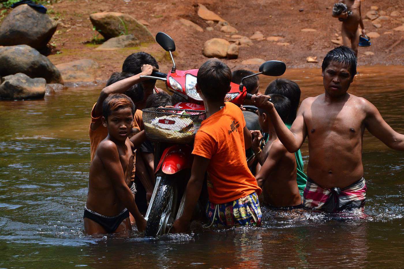
C est que de la piste avec un tas de passage de rivieres, voir photo
Je pars dans 4 semaine pour le LAos à vélo avec ma petite de 6 ans dans la charette (c'est sa deuxième expérience après la Thailande il y a deux ans). Je fais…
Je m'adresse autant aux amateurs de vélo qu'à ceux qui par d'autres moyens ont parcouru des pistes au Laos. Fin janvier 2016 nous partons au Laos pour un mois,…
On est parti de France il y a 6mois sur nos montures et nous voila au Cambodge a siem reap pres a visiter les temples d'Angkor. La prochaine etape est de…
Je suis nouveaux sur le forum. Comme ils est difficiles de trouver de très bon vélo au Laos, quel est la procédure pour emmener sont vélo par avion? Si vous…
La carte Reise-know-how LAOS signale des bateaux faisant des liaisons au nord de PAKSAN (nord-est de VIENTIANE, au bord du Mékong) vers THATOM sur la Nam Xan…
I’ve gotten used to crossing Europe by bus to return by bike.
It was really convenient to take the bike without having to disassemble it.
But FlixBus no longer accepts bikes...
What alternatives do you know about?
Thanks.
I’m planning to cycle from Morlaix to Brest (via Roscoff and the V45 coastal route). We’ll start riding on August 16th for 13 days (with stops for island visits, surfing, etc.). Is there a lot of traffic at this time of year? I’ve got two kids, 11 and 13, and we don’t like riding in the middle of cars (we’ve already done the Vélomaritime—Caen to Cherbourg—the Loire route from Orléans to Saumur, the Vélodyssée from Nantes to Royans, and the canals like the Nivernais and Bourgogne, where there were plenty of bike-only lanes, which isn’t the case on this route).
Thanks for your help if you’ve already done this route in late August!
Virginie
I’ve got my flight ticket sorted—departing in mid-November and returning in mid-March. I’ll arrive in Santiago and leave from Buenos Aires.
I’ve already been to southern Argentina, specifically Torres del Paine National Park, and I’d love to go back to do the full W trek (I only did the shorter version last time).
I also want to do some hiking and maybe even tackle a summit. I climb and occasionally do some mountaineering, so I’ll definitely be going with a guide.
I plan to start around Temuco in Chile, with the idea of heading toward the lakes, then taking the Carretera Austral.
I’m not sure if I’ll go all the way to Ushuaia—it’s supposed to not be *that* worth it, except for the bragging rights of saying you’ve been to the end of the world.
I saw there are lakes in Argentina too.
I don’t have a precise itinerary, but what I’d love is, once I reach the southernmost point of my trip, to take a mini-cruise to see some wildlife. Any tips for that?
What kind of sleeping bag did you take? Is a 0°C (32°F) one enough?
And one last question: white gas stove or can I get by with my gas stove?
This summer, we’re planning to cycle along the EV 19 that follows the Meuse River from Langres all the way to Rotterdam.
My question is about getting back to Nantes.
Do any of you know what the best return option might be? I’d love to hear about your experiences.
I saw that FlixBus doesn’t take bikes.
By train, I think it’s possible but would involve multiple local trains.
We were also wondering if there’s a boat from Rotterdam to Saint-Nazaire that could take passengers with bikes.
Any tips or experiences you can share would be really helpful—thanks in advance!
Have a great evening
Hi there,
I’ve been road cycling for several years, and I’m about to switch to gravel in the next few days—I’m waiting for my bike, which should arrive this week.
I’m planning a bikepacking trip in a few weeks along the Véloroute V81, also known as the Vélosud, from Biarritz to Le Barcarès.
Has anyone here already done this route? Any info is welcome, whether it’s about the route itself, gear, or accommodation. I’ll prioritize staying with locals as much as possible. On that note, I just signed up for the brand-new site *Guidon et Couette* ((www.guidon-et-couette.fr)), which offers free accommodation between cyclists across the country, but there’s almost no one listed along my route!
Thanks in advance.
Laurent.
I’m planning to build a new touring bike.
I want to prioritize lightness.
That said, I’m tempted by a suspension fork that could offer some comfort on rougher roads.
The recent appearance of gravel suspension forks on the market might meet my needs—at least on paper.
I’m particularly considering the RockShox Rudy Ultimate XPLR fork.
Unlike MTB forks, its travel is short: either 30 mm or 40 mm.
It weighs 1400 g, which is 400/500 g more than a steel fork.
Any thoughts or real-world feedback on this?
I’m also wondering about the durability of magnesium (lower leg) for long-distance bike touring.
And what’s the impact of skipping the manufacturer-recommended maintenance every 50 and 200 hours? That’s bound to happen on a long trip unless you carry extra gear.
More generally, how reliable are these kinds of forks?
Hi everyone,
I wanted to share with you the incredible feat my friend José, who’s 72 years old, is currently undertaking. He left Auterive near Toulouse on Monday, May 18, 2026, on his non-electric bike, heading for the North Cape in Norway!
You can follow his route on the link below—he’s currently in Sweden:
https://thierry-thomas.travelmap.net/jose-de-toulouse-a-nord-cap-2026
You can zoom in on the map and click on each stopover town to see the photos
I’m making an exception and creating a separate post this time, since it’s all about France. In May, we spent a week in Provence, specifically in the Luberon, exploring the cycling routes *Autour du Luberon à Vélo*, the *Véloroute du Calavon* (part of EuroVelo 8), and the shorter *Les Ocres à Vélo* route. Together, they gave us an amazing journey through rolling hills, vineyards, lavender fields still green in spring, and some of the most stunning landscapes in southern France.
It was, of course, the perched villages that impressed us the most. We visited Gordes, Roussillon, Bonnieux, Lacoste, Lourmarin, Ménerbes, Oppède-le-Vieux, Cucuron, and Lauris. Many of them are among the most beautiful villages in Provence, and it’s hard not to agree with that reputation.
One interesting point is the route of EuroVelo 8 in this part of the region. The official path mainly follows the old railway line of the *Véloroute du Calavon*, which is very comfortable and safe. But in our opinion, cyclists traveling EuroVelo 8 around the Mediterranean would discover even more treasures if the route passed through villages like Bonnieux, Lacoste, or Oppède-le-Vieux.
We were also pleasantly surprised by how safe cycling felt. Most of the route takes small local roads, but traffic is light, drivers are respectful, and road design really takes cyclists into account. It’s one of those places where you can ride peacefully even without separated bike lanes.
Our full story:
Around Luberon by bicycle - the most beautiful villages of Provence
You can also find all our cycling travel stories on the forum:
Cycling Thread - Europe’s most beautiful bike routes
Hi there, we’re a group of 4 cyclists looking to get from Treviso in Italy to Munich with our 4 non-folding bikes. It seems complicated! Are there any solutions? Thanks so much.
hello fellow cycling enthusiasts
here’s a travel journal of the cycling tour through the Rhône-Alpes Auvergne region by Claudio
zouli
it was the plan
http://cbandiera.free.fr/parcours/auvergne-Ralpes/
the trip was completed
story being posted online soon
1100 km in 11 days
beautiful and varied regions
Hi there, we’re planning a Munich to Venice bike trip at the end of June 2026. Getting back from Venice to Toulouse by train with 4 bikes isn’t straightforward. What return options have others who’ve done this trip chosen? Any tips or great deals would be much appreciated. Thanks a bunch! !
Hi everyone,
Happy owner of a Pegasus Estremo bike with a Rohloff hub, which is giving me trouble with the SF11-NCX-FT-E-LITE 700C TS 300/0 fork (serial number TD01329060). It’s starting to show its age, and I’d like to repair it to extend the life of my beloved bike.
The suspension is gone, and there’s an oil leak from the seals.
Does anyone know how to repair it? Where can I find parts that are about fifteen years old? Or where to find an identical replacement fork? Just to clarify, the Magura HS11 brakes are mounted using Firm Tech, meaning they’re on pivots behind the fork, facing the frame.
Hi, I'd like to know if anyone has done this route recently or has reliable info.
Does the track exist, and most importantly, is there sand (for biking)?
Any info is welcome.
Cheers,
diego ambilobe: mangaoka, manondro, ramena
vohemar sambava: masondrono, tanambao
Hi there,
New to bike touring,
I’d love to start with a section of the Via Rhona to explore and share (route to be decided).
Looking forward to exchanging tips!
I’m landing in Madagascar with a buddy before the end of April 2026. We’re planning to bike around for about twenty days or so. We don’t have a specific goal other than exploring the country and meeting the locals.
Ideally, we’d prefer a loop route starting from Antananarivo with a good chunk of it along the coast. On the bike side, we’re used to riding 6 to 8 hours a day, depending on the needs, encounters, and mood 😉 Any feedback or tips from trips around this length?
A big thank you to Lazarou for all the info you share in this forum!
I'm passionate about Morocco, which I cycled through back in 2009.
Last year, my wife and I explored the High Atlas by tandem. Completely smitten, we're heading back in April (Anti Atlas) and May (High and Middle Atlas), still on our tandem.
Do you have any info on the track between Amezri and Ali Ait Nito? Are the river crossings in the Tessaout still there? It's not easy to navigate with a loaded tandem... especially if the river level is high due to this year's heavy snowmelt!
Thanks in advance for any tips you might have, and best wishes for health in this new year!
Claudio specializes in the route of the Savoie lakes
Here are his travels
Between Bornes, Chartreuse, the Savoie foothills, and Dauphiné
Five lakes: Léman, Annecy, Paladru, Aiguebelette, Bourget, not to mention a few ponds along the way
Plenty of accommodation options: camping, hotels, and more...
A lovely route not far from his place
Rural and quite peaceful
A road cycling route created by Serge B...
Tout d'abord... bonne année ! De belles routes à vous en 2017 !
Je voyage depuis quelques années avec un VTT de très bonne qualité mais équipé de freins à disques hydrauliques. Je vis (pédale) avec l'inquiétude d'avoir une panne (fuite, bulle d'air, chaleur qui fait que le liquide...). Mon vélociste me dit qu'il est impossible de les changer pour des V brakes.
Qu'en pensez-vous ? Est-ce que je prends un gros risque à continuer (seule) avec ces freins ? D'avance je vous remercie pour vos bonnes idées.
First post here to share a quick recap of our west-to-east bike trip along Algeria’s coast in January 2025.
It was just the two of us—my partner and I—with French passports and not a word of Arabic. No friends or welcoming hosts in the country.
Under those conditions, we’d strongly advise against going.
Our original plan was to follow the coast from Algiers to Tunis. We ended up cycling from Algiers to Béjaia, then took the train from Béjaia to Annaba (with a stop in Constantine), and finally biked to the border.
We were tailed by police the whole way—whether on our bikes, on the train, or even on foot while exploring towns. On top of that, we couldn’t wild camp and were limited to the few state-approved hotels that accept foreigners. Under those circumstances, connecting with locals was especially tough.
With such an omnipresent and intrusive police presence, we’d definitely recommend against this destination for bike touring. A really sad situation that completely cuts you off from the local population...
We’d been warned, we went to check it out, and we weren’t disappointed!
Hi there,
I’m planning the route to cycle from Lille to Nordkapp with my partner.
Duration: 3 months, from May 1st to July 31st, 2026.
In the attached details below, I need to add some "non-riding" days (rest days, basically).
So I’m looking to "shorten" the trip by taking ferries or trains for some stretches. Which areas could I skip?
Thanks in advance for your great tips.
Have a good evening.
https://www.komoot.com/fr-fr/collection/4023980/-lille-cap-nord-1er-mai-au-31-juillet-2026?ref=collection
I’m planning to bike back from Poland this summer. Does anyone know a way to ship it there without having to take it apart? Otherwise, it’s a real hassle to fine-tune all the settings before departure!
Thanks in advance.
Hi, has anyone recently bought Primus or Butagaz gas, possibly puncture-style, in Dubrovnik or the surrounding area? Same question for Albania... thanks. aichatou
Just a few words about the loop I did by bike in Yunnan.
Entry and exit
I entered China through the Sino-Vietnamese border crossing at Lào Cai / Hekou under the 30-day visa exemption currently available to French nationals and others.
The process was simple and quick. A Chinese police officer even helped me complete my electronic pre-registration at a computer kiosk. I wasn’t aware this formality was required—it’s similar to Thailand’s TM6.
No issues with the bike.
I left the country via the Sino-Laotian border crossing at Mohan / Boten.
The atmosphere was a bit chaotic there, but again, no problems with the bike.
The timing
I visited Yunnan in February 2026.
Weather-wise, at higher altitudes (between 1,500 and 2,000 meters), it was around ten degrees at night and in the mornings, and around twenty degrees at the hottest part of the day.
I had two days of rain, so I took the bus to keep moving. Otherwise, clear blue skies.
Culturally, Chinese New Year fell on February 17th (and the 15 days following), right in the middle of my trip. Because of this, my take on the traffic might be off.
Accommodation and food
I always found a hotel to stay in for prices ranging from 8 to 15 €. Except in Kunming (the capital), where many hotels were fully booked (Chinese New Year). I ended up at a 100 € hotel with great value for money.
A bowl of noodles costs about 1.5 € on average.
Onboard electronics
Since my smartphone doesn’t support eSIMs, I subscribed to a China plan with my carrier. Otherwise, for much cheaper, Alipay offers eSIMs for foreigners that allow access to services usually blocked for Chinese users (WhatsApp, Facebook, etc.).
An internet connection is essential for paying with Alipay or WeChat, as this payment method is widespread.
I only managed to use Alipay.
Either way, always carry cash because sometimes there’s no signal, or the merchant only accepts WeChat.
Also, it’s best to bring a power adapter when you arrive rather than struggling to find one.
Traffic and roads
The Chinese aren’t reckless drivers. They follow traffic rules and watch out for cyclists. This is slightly less true in Xishuangbanna (the region bordering Myanmar and Laos).
In urban areas, there are almost always wide bike lanes, separated from other roads, where bikes, electric mini-scooters, and scooters share the space pretty harmoniously.
The roads are in great condition, and traffic is generally manageable—even light—except for one stretch (Eshan -> Yangwu).
Most traffic is absorbed by expressways, China’s equivalent of highways: toll roads that are off-limits to slow vehicles.
You’re never far from these expressways; sometimes you even ride alongside them, which can be noisy at times.
The climbs are usually reasonable, around 5% to 6%. From what I remember, the steepest section was between Menglun and Mengla, with gradients of 8% to 10%, sometimes more.
Riding at these altitudes—though modest—took a bit of getting used to.
The route
I didn’t plan anything in advance. My only goal was to reach Kunming. I don’t know why, but just hearing the name of that city, like Yunnan, always felt dreamy to me.
Hi! I’m planning to visit the Stockholm Archipelago by bike in early April.
Do you know if the boats will be running between the different islands at that time of year? For those who’ve already been, all your tips and recommendations are welcome—accommodation, etc. Also, do you know where I can rent a bike in Stockholm? Thanks so much in advance for your help!
Hello there, pedal-powered Young Boys!
Claudio (still from Faverges)
dreaming about a cycling getaway in Italy from Faverges (train all the way to Turin)
from Turin down to Venice along the Po River and back via the Padana (Alta Italia da attraversare – Northern Italy to cross)
The tricky part is getting from Chioggia to Venice.
I read it’s possible by hopping on a boat from island to island,
but it sounds a bit stressful.
Has anyone already tackled this route?
I’m currently looking for a bike to do my first bike trip across France, with the ultimate goal of cycling through Latin America. I’ve got a lot of questions and I’d love to hear if you have any answers or advice to share.
First off, I’ve been through this before with hiking. I want to get top-quality gear right away. When I started hiking, I ended up buying everything three times—first beginner gear, then intermediate, then expert, etc.
For biking, I’d prefer to skip that process and invest right now in a bike that could ideally handle Latin America.
I’ve set a total max budget of around 5000 € (roughly 4000–4500 € for the bike and the rest for accessories: panniers, helmet, cycling shorts, etc.).
So, I’ve got quite a few questions:
* I’ve read in several places that some people recommend buying the bike directly in Latin America. Since I need a first bike to train in Europe, would it be better to buy an entry-level bike in France (and sell it before the big departure)? Or is it preferable to start right away with my final bike to get used to it? Is buying it there just to save a bit of money?
* For a long-term trip (around six months) in Latin America, is it better to go for a gravel bike or a mountain bike?
* Should I buy a new bike or a refurbished one? Even more so given that I’m planning a long trip—could a refurbished bike end up causing more breakdowns?
If you have any advice on models, technical features to prioritize, or recommended sellers or resellers, I’d love to hear it. I’m a total beginner—I’ve only just started watching videos and reading up on the subject, and all the technical specs are new to me!
Calling all travelers.
We’ll be landing at Lyon Airport and want to bike to La Verpillière train station (with panniers and camping gear, etc.) to catch a TER to Voreppe.
What’s the safest route for this bike trip?
Thanks in advance