VeteranMar Del Plata. Province de Bue · 1,404 posts
Bonjour aux passionnés du Machu Pichu; j'ai un ami qui arrive pour voyager vers le Machu Pichu et gravir celui-ci le 2 août 2008, on vient de l'attrister en lui disant que ce n'était plus possible.
Qu'en est-il exactement? Quelqu'un pourraît-il, si celà est exact (?) m'en donner la raison.
Je vous fait entièrement confiance pour une réponse digne d'un VF.
Encore merci.
Chegringo.😉
No deje crecer hierba en el camino de la amistad.
"Il y a les vivants, les morts... et ceux qui partent en mer." Victor Hugo.
Le Machu Picchu n'étant pas un sommet, mais une cité, le mot "gravir" est un peu fort. On peut monter jusqu'à la cité en train, bus ou à pied, mais c'est tout.
Par contre, il y a la Huayna Picchu, un sommet qui domine le Machu Picchu, qui même s'il est très facile, on peut dire "gravir".
Mais, je suppose que tu parlais de monter à la cité ? C'est ca ?
Pour l'Inca Trail = faut oublier, c'est blindé tout l'été. Faut prendre un itinéraire bis (pour monter à pied)
L'accès au site en lui même par contre, ne pose aucun problème, pas besoin de réserver.
Pour plus d'info, fais une petite recherche, c'est déjà remplie de messages sur le Machu Picchu sur VF 😉
Je ne saurais pas dire si il est trop tard ou pas pour s'inscrire sur l'Inca Trail. Mais comme le dit Simon, l'accès (par bus) au Machu Picchu depuis Aguas Calientes ne nécessite pas de réservation.
Mais, techniquement parlant, le Machu Picchu est bien un sommet (ça veut dire "vieux pic" en Quechua) qui a donné son nom à la cité qu'il surplombe. Il est situé de l'autre côté de la cité par rapport au Huayna Picchu. Pour y monter, il suffit, depuis le site, de se diriger vers la porte de soleil et prendre assez rapidement un chemin inca qui part sur la droite et qui mène directement au sommet (600 mètres de dénivelés). Le point de vue là haut est sympa, ça change de celui du Huayna Picchu et il y a surtout beucoup moins de monde.
Merci d'avoir corrigé, c'est vrai qu'il y a 2 sommets, j'en ai zappé un 😕
Le Huyana Picchu et le Machu Picchu (sommet) et la cité du Machu Picchu se trouve au milieu
Salut,
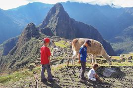
les photos sont très jolies. Tout à fait d'accord avec toi, par contre, je ne savais pas qu'on pouvait monter au machu picchu !!! Il me semble voir l'embrenchement dont tu parles en allant vers la porte du soleil, mais après il passe par où le chemin ? Il contourne par l'arrière ?
Christophe
En effet, je pense que la "tache" vert clair sur le chemin vers la porte du soleil est bien là ou part le chemin vers le sommet du MP. Le chemin reste sur ce versant en tirant un peu sur la gauche pour atteindre la crête à peu près à la bordure de la photo. Le chemin est en très bon état, c'est en fait pas loin d'être un escalier en pierre tout du long (sont forts ces incas !), c'est probablement moins raide que le Huayna Picchu et il y a un passage un peu vertigineux (pas spécialement dangereux) sur l'arête pour arriver au sommet. Par contre, à éviter si tu vas là bas avec ta grand mère : 600 mètres de dénivelés assez raides et il fait généralement assez chaud. On a croisé 5-6 personnes max et nous étions tout seuls là haut....bref, je crois que c'est un peu le "bon plan" du MP pour ceux qui cherchent à s'éloigner un peu de la masse touristique.
🏴☠️.Ne vous disputez pas pour savoir s'il y a sommet ou non, ma question était, plus simplement, n'y a-t-il pas de restriction pour l'instant, pour y accéder? (le site serait éventuellement fermé pour des questions de sécurité!).
Je crois que l'an passé il fût fermé pour des coulées de boue.
Qu'en est-il?
De toute manière le voyage est programmé.
Merci de votre aide.
Chegringo😉
No deje crecer hierba en el camino de la amistad.
"Il y a les vivants, les morts... et ceux qui partent en mer." Victor Hugo.
Merci pour toutes ces info !
Je sent que je vais le faire dans tous les sens ce MP ! 😉 Et je vous dirai quel coin j'ai préféré, Héhé...
Je pars début juillet et question sécu au MP, je verrai bien sur place. Je me laisse porter par le hasard...
Le Machu Picchu au mois de mai dernier :
1°) Le trajet en bus d'Agua Calientes jusqu'à la cité du Machu Picchu : 30 $ dollars aller-retour
2°) Le trajet à pied d'Agua Calientes jusqu'au Machu Picchu : 1h30 de marche (pour les plus lents) et gratuit
3°) A pied, nous sommes arrivés avant les 1ers bus (ils arrivent vers 5h45) et nous sommes entrés dans la cité inca parmi les premiers et c'est une véritable claque dans la gueule ;-)
4°) Le lever du soleil qui vient illuminer le Machu Picchu est tout aussi splendide (si la météo est au rendez-vous).
5°) Pour la Wayna Picchu, seulement 400 personnes peuvent y accéder par jour (nous sommes passés vers 8h du matin et nous étions 202 et 203èmes).
Nous avons réservé nos billets le 13 mai pour un départ le 14 (le dernier train à 18h50) et un retour le 16 (à 5h40 du mat').
Je suppose que ce sont des horaires pas très prisés, d'où la facilité de réserver nos billets si tard.
je suppose que c'est quand même une trotte dans les pattes avant de continuer sur le site non?
Ma crainte est d'arriver déjà un peu fatigués et de me trainer tout le reste du temps sur le site ... Parce que je ne voudrais vraiment pas louper (par fatigue) le Wayna Picchu 🤪
Tout dépend de ta condition physique ;-)
Pour info, même à 4h30 du matin, il fait déjà fort chaud dans la vallée (heureusement, plus on monte, plus il fait frais).
ciao
alors je ne peux pas confirmer mais je suis allée au machu pichu en OCTOBRE 2007 et j'ai vu le chemin qui arrive du fleuve, il est raide mais praticable, cela économise aussi les 40 dollars d'entrée. Par contre je ne sais comment rallier le fleuve à ce point, à part en venant de aquacalientes à pied, ce qui représente environ 8 km je pense
bon voyage!!
valérie😮
Qui lui a dit aue ce n'était pas possible ?
Moi, je l'ai fait en 2004 : 45 minutes pour accéder au sommet de Hayna Picchu, nom de la colline qui domine les ruines.
Bonjour,
Nous souhaitons faire le trek de 4 jours reliant Mestia à Ushguli sans agence. Il est précisé dans les descriptifs qu'il existe des hébergement à chaque étape, mais on ne trouve pas d'info sur ces hébergements. Quelqu'un a-t-il des infos et un avis sur ce parcours?
We're planning to trek in Peru and Bolivia and would love to find some local agencies.
If you know any, could you share details on prices and, of course, the names of the agencies?
Which trek would you recommend?
Elocine
Je pars en autonomie totale sur un trek au Maroc (10jrs) Imilchil - Aghbalou.
Trouve t-on des cartouches gaz à vis (Coleman, Primus) à Marrakech (adresse) ou villages entre Imilchil - Aghbalou ?
Si non , trouve-t-on des cartouches Butagaz pour camping-gaz (petit volume 230 gr ...)
Merci d' avance pour vos réponses
Hello, I’d like to embark on a little trip in my home country, Switzerland. I’ll start walking from La Cure, heading toward Le Noirmont first, then I’ll improvise my route—but it’ll probably follow the French border... at least as far as Lac de Joux.
I’ll decide day by day how much farther to go after that. My goal is to stay in nature as much as possible, wander around for as long as I can, and restock food in villages or towns along the way.
I’m thinking of mostly camping, but we’ll see if I end up in a hotel or another campsite depending on my route.
I’d love to reach La Chaux-de-Fonds on foot... maybe even Delémont.
The whole thing should take about a week, give or take.
I’ll be bringing my dog, and I’m preparing for this as soon as I’m ready.
Any tips to make sure everything goes smoothly for us? Things I should know—or avoid? What about shepherds with their flocks of sheep? And isn’t hunting season open right now?
I’m not sure if what I’m planning is even doable, which is why I’m asking around.
This’ll be my first time doing something like this—wandering in nature *and* with a dog. I’m really excited for this adventure... and I need it. Thanks!
We’re really keen on ecosystems and want to hike in "natural" ancient forests—not planted woods or areas heavily degraded by human activity. Travel guides (like Lonely Planet) don’t provide much info on this. Could you point us to the most interesting spots?
Thanks in advance for your tips.
We wish you happy holidays and a fantastic 2026, full of discoveries!
Claire and Albert
Hi, this might not be the right section, but I’d like to know if it’s possible to start mountaineering with another person without necessarily hiring a guide. We’ve done quite a bit of hiking but not mountaineering—we’ll just do a half-day glacier course. After that, we were thinking of starting with La Grande Motte and the Pointe de la Traversière, which were recommended to us. Honestly, for things like roping up and knots, I’ll learn at home with lots of videos and a book.
Hi,
I don’t know Switzerland at all and was wondering if Vallée des Joux and especially Dent de Vaulion are packed early in the morning or late in the afternoon in July and September?
If so, do you have any quieter spots to recommend in the area, or in Luxembourg (yes, I know it’s not the same country 😉)?
Thanks a lot!
Jaimerais savoir si quelqu'un aurait fait des treks sur le Ruwenzori et combien ça coute en moyenne, les infrastructures, les paysages la sécurité sur les lieux, merci beaucoup. J'attends avec impatience vos réponses.
We’re leaving in 9 days for a two-week trip to Madeira, mainly to hike.
From my research, I’ve found that since last year, access to most trails—and systematically for the most popular ones—is now paid. You have to pay an access fee of 4.50 € per person per classified hike in 2026, and even 10.50 € for the most iconic hike: Pico Arieiro to Pico Ruivo. When paying, you also have to choose a day and a 30-minute time slot for your start time. Of course, this reservation is neither changeable nor refundable, even if the weather that day is terrible.
Personally, given the massive influx of tourists to the island in recent years, I don’t mind paying a fee to help maintain the trails. Similarly, setting a limit on the number of people who can hike them per day is certainly preferable to preserve this priceless heritage.
However, what’s much less fair is that in reality, most of the available spots are reserved: 1/ for Madeira residents (which is normal); 2/ for "economic operators" (meaning local tour operators). For example, if you’re a non-resident (independent tourist), no booking is possible for the Pico Arieiro hike for an early morning start before September! So, unfortunately, we’ll have to skip this hike.
It’s the same issue for Ponta de São Lourenço, the 25 Fontes, Pico Ruivo... in short, all the most popular hikes. Oh well, we’ll skip those too!
So my question is: which hikes do you recommend where we won’t face the huge crowds that the others get? And where we can book the day before for the next day, taking the weather into account?
Finally, a quick accommodation question: we’ve booked the first week in Funchal, but I haven’t decided yet for the second week. Do you have any advice on where to stay in the south or north, preferably avoiding overly concrete-heavy and touristy spots?
I’m reposting about the logistics for Samaria Gorge.
I’d love to get recent info, especially about whether it’s possible to park my car in Omalos, do the hike, and then catch a bus back to my vehicle.
In theory, it’s doable, but when you check the KTEL website, there aren’t any feasible schedules listed. If anyone has recently organized this with reliable, verified details, I’d really appreciate it. Thanks in advance!
Hi there,
We’re flying from Montreal to Lyon this August to go hiking in the French Alps. We’ve rented a car and will be staying at campgrounds. We’re planning to do day hikes and want to stay a few days in one spot, do a few hikes, then move on to our next camping spot. Could you share your favorite spots or any recommendations for places to spend a few days with great hikes?
A few details:
We arrive in early August and leave in early September.
We’re looking for day hikes (or shorter), moderate difficulty, with a cumulative elevation gain of no more than 1000m, and of course, beautiful scenery!
We’d prefer not to drive too much—maybe it’s best not to head too far south and deal with unnecessary heat?
Along the same lines, if you know of any great campgrounds where we can start our hike directly without needing the car, we’d love to hear your suggestions!
Bonjour
Souhaitant faire de la randonnée sur cette île, je voudrais d'abord savoir quelle serait la période la plus favorable sachant que j'avais passé quelques jours en novembre 2018 pas pour cette activité mais plus pour une simple découverte de l'île et le temps n'était pas top notamment en montagne. Donc peut on choisir une organisation en étoile sachant que je louerai un véhicule avec éventuellement 2 points d'hébergement.
Je n'envisage pas d'intégrer une structure mais de partir à 2 et de s'organiser sauf si vous me conseillez une agence locale ou un guide local. Enfin même si je compte me procurer les différents supports, carte et topo guide plus gps je vous remercie de bien vouloir me communiquer les randos à faire en priorité
Merci beaucoup pour vos informations
I’m planning to do the Mercantour crossing following the Randoxygène route in mid-July.
I’m used to hiking in the mountains, but I sometimes get vertigo, for example on ridges with drops on both sides. I wanted to check if there are any T4 or T3-T4 sections and find out if there are any very exposed passages—and if so, where—so I can plan an alternative route.
Can anyone give me some info on this?
Thanks!
I’m planning a trip around Cap Corse and the AGRIATES in 2026, from May 8th to 15th (there are still 2 spots left, by the way! Just DM me if you're interested).
I’d love to know which hikes are worth prioritizing in the AGRIATES. We’ll be staying in SALECCIA for two days as our base—what should we focus on from there?
A round trip to IGNHU beach? Any other suggestions?
For Ostricano, I think it’s too far for a round trip...
Thanks for your tips!
Have a great day,
Anie, Toulouse
I’d like to get some info about the GR10 Pyrenees traverse. I need help planning the daily stages and accommodations—my wife isn’t an experienced hiker but walks a lot, so I’d like to schedule shorter walking days and thus a longer overall trip in terms of number of days.
Could anyone give me some help and advice?
Best regards,
New to this forum, I’m planning a pretty big project for 2028.
I’m heading to Nepal to do a trek from Kathmandu all the way to Everest Base Camp (a cool 5,300 m 😄).
This trek is a bit special because even though I’ll be part of a group, I’m going solo (so far, no problem—I’m used to it). But it’s my first real trek, and it’s also a humanitarian one: once I reach base camp, I’ll stay an extra week to help clean up the waste left by tens of thousands of climbers! Since I’m originally from South America, from two countries that share the Andes, I have a deep respect for mountains—they fascinate me. So Everest… it’s kind of the trip of a lifetime!
So, a little question for those who’ve done treks to Everest before… any tips for good mental preparation (I’m already working on the physical side)?
Hi there, I’m planning the Annapurna Circuit for March 2027 and I’m looking for a local agency with a local guide—preferably French-speaking—to arrange this trek for us. Any suggestions? Thanks
Hello!
We’re spending a few days in Toraja country at the end of May. We’d love to do a day trek—taking our time—on a route that’s stunning in terms of scenery, but not a level 5 in difficulty!
Any suggestions you can share, please?
Thanks in advance
I’d like to do the Mare a Mare Sud in May over 4 days. I’ve found quite a few places to stay along the route, but I’m stuck on the start and finish.
I’ll be arriving by plane on Sunday evening and would like to start pretty early on Monday morning. Ideally, accommodation right at the trailhead (Alzu di Gallina) would be amazing, but I can’t find anything. Any tips?
Also, for the transfer from Figari Airport to Porto Vecchio or Alzu di Gallina?
At the end, I’d like to pick up a rental car—any advice on that too?
I’m traveling solo by plane to Catania in May and plan to hike the northern side of Etna, starting from Linguaglossa where I’ll arrive by bus. After that, I’d love some info on how to get up to Piano Provenzana (shuttles or hitchhiking), since it seems there’s no public transport except in the summer. Can you sleep there in a free or cheap refuge, or camp? And how far up can you go without having to hire a guide? Thanks in advance. Bernard.
Bonjour a tous,
je pars en voyage au Maroc en aout et nous allons commencer par nous arrêter a Chefchaouen(nous sommes en voiture).
Ma question: quelqu'un peut il m'indiquer un itinéraire de rando en boucle d'entre 5 et 7 jours aux départ de Chefchaouen dans le parc de Talassemtane passant si possible par le pont de dieux?Ou un guide papier qui en reunis quelques uns?
Nous privilégions le camping sauvage et les gites.
Merci d'avance
Hi there, for those who’ve been recently—is it possible to find other solo travelers in March on the island to share transport or room costs? It doesn’t seem easy to travel on a budget.
If you have any recommendations for simple lodgings or places with dorms, I’d love to hear them.
For those who’ve done multi-day treks while moving around: do you need to bring your own sleeping bag? I’d love to hear about itineraries you’ve done without a guide, just with a map and GPS.
Thanks, and have a great day!
Hi everyone!
We’re planning a 15-day road trip to Scotland this summer, specifically to explore and hike on Lewis and Harris—places we’ve never been before. We’ve visited other islands on previous road trips in Scotland (we usually go in April for a week). This would be our first time in Scotland in the summer and for 15 days. We’re looking at late August to early September.
I’m currently drafting the itinerary. We’d be crossing from Ullapool and were thinking of spending 3 nights on Harris and 4 nights on Lewis.
Does that sound balanced to you? Is it better to keep the same accommodation on Harris and the same on Lewis to explore the area? I’d love to hear about any past experiences you’ve had on these islands.
Thanks!
Hi there, I’m trying to leave for 15 days very soon to São Vicente. I’m either looking to join an agency or figure things out on my own to go hiking on one of these islands or both. From what I’ve seen, it’s not easy to organize with local transport, so it gets expensive. Can I use the services of a small local agency? I’m looking for the simplest way to hike for several days. Also, how do you get from São Vicente to São Nicolau? Thanks in advance and have a great day!
Aichatou
I’ve been wanting to do this for several years, and this year’s the one. Next September, I’ll be trekking in Tusheti (Georgia), from Omalo to Shatili.
Of course, I won’t be renting a vehicle that’d just sit unused. No problem getting to Pshaveli, but from there to Omalo, it’s a dirt road (still the case?)
There must be some form of public transport since there are so many guesthouses, and not all travelers come in a 4x4.
If any of you have been to Omalo, could you confirm that these shared transports exist and how often they run?
we’re planning a trip to Yellowstone and hoping to do a three-day backcountry hike if we get a permit.
if any of you have done this before, could you let me know if it’s possible to find water along the way? And if we can transport it, are we allowed to use a stove?
Hello,
I’ll be in Nepal from March 6th to 29th (we’re flying into Kathmandu via Varanasi and leaving via Delhi).
I’m a bit confused about the regulations requiring a guide.
My wife and I (we’re 63 and 64) aren’t experienced trekkers—we’re more used to walking on terrain with very moderate elevation changes. I’m looking for fairly easy hikes, possibly day trips.
Here are my questions:
- Does the Poon Hill trek from Pokhara require a guide, or is it better to go through a local agency? (I’ve seen a lot of them offering 4-day packages)
- I’d like to do a few multi-day hikes around Jomsom (Kagbeni, Mukitinath, Lupra, Marpha)... Do you need a guide for those, and can you find accommodations easily without booking in advance?
Last question—I’m really hesitant to lug around a sleeping bag or down jacket during our 6 weeks in India. Can you easily find these kinds of items at reasonable prices in Pokhara?
Thanks in advance for any tips you can share!
Yann