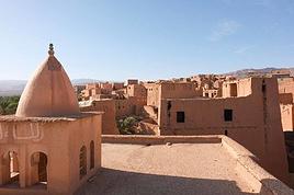
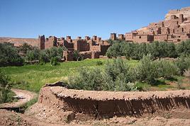
Je vais me rendre au Maroc en Novembre prochain avec mon épouse. Nous avons l'intention ( Entre autres..) de faire la traversée à pied du Djbel Saghro en principe à partir de Boumalne du Dades pour terminer à Nkob.. cela sur 3 ou 4 jours avec un départ autour du 3 ou 4 novembre...
Je suis à la recherche d'un guide connaissant bien le coin. J'aimerais qu'il habite proche du Saghro( région de Boumalne de préférence) sinon au plus loin la région de Ouarzazate...
Je me suis rendu au Maroc l'année dernière. J'y ai rencontré un guide qui est devenu un ami tellement il est gentil. C'est un jeune maroccain au grand coeur, amoureux de la montagne. je vous donne son mail; n'hésitez pas à le contacter de la part de Laurent.
Salut
Ce guide habite t-il la région du Djbel Saghro?.. ou à la limite a-t-il déjà traversé le Djbel à pied? si je cherche un guide mieux vaut qu'il soit compétant sinon je peux me débrouiller sans...
Il habite à Boumalne du dades et a déjà trekker dans beaucoup d'endroits au maroc. ca n'est pas là que j'ai été avec lui mais si tu le contcates, il te répondra sans problème.
Bonjour,
Si vous ne trouvez pas de guide conseillé par l'un des participants je vous suggère, une fois sur place, de vous renseigner au bureau du tourisme, ils vous désigneront un guide officiel.
Si vous voulez être assuré de trouver quelqu'un de compétent avant votre départ, le mieux est de contacter une sérieuse agence réceptive locale, ils vous désigneront aussi un guide officiel.
LA liste des agences réceptives est longue, vous en trouverez facilement sur Internet (visitez leur site pour avoir une idée de leur activités),
Ca sera un peu plus cher que de trouver un guide directement mais au moins vous n'aurez pas de surprise quant au respect du rendez-vous et de la compétence de votre accompagnateur.
Bon courage et tenez nous au courant de votre voyage
Dana
Je fais cette randonnée l'année prochaine une semaine le djebel sahro et la semaine suivante dans le haut atlas
Chaque année, je pars avec un petit groupe pour randonner au Maroc et je prends
un guide sur place le m^me depuis environ 5 ans et quelque soit l'endroit aucun souci, il travaille avec des agences
de trekking et en solo et n'est pas cher
Avec lui, la vallée des Roses, 2 fois le Haut Atlas , Essaouira et en mars le Djebel Sahro
Si tu veux je te donne son mail et tu le contactes de ma part, c'est un vrai berbère
bonsoir
je connais un bon guide!! il connait bien le sarho il habite pres de boumalne
ces tarifs sont correct!! il a deja enmener mes amis marcheurs a plusieurs reprises et en sont revenu tres tres content!!!! j habite au maroc a ouarzazate voici mon adresse mail (taromite@yahoo.fr )vous pouvez me contacter je vous donnerai ses coordonee si vous le desirez et si vous avez besoin d autre renseignement n esitez pas
chris
Bonjour
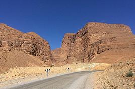
Je me demande si le trajet de boumalne a Nkoub est possible avec une petite voiture. Sinon, est ce que c est indispensable d'avoir une 4/4. Je compte faire ce trajet le 18 Janvier. Aussi, je suis tres intresse par la geologie alors est ce qu il un conseil pour les arrets a faire et les choses a anticiper voir.
merci
Je me demande si le trajet de boumalne a Nkoub est possible avec une petite voiture. Sinon, est ce que c est indispensable d'avoir une 4/4. Je compte faire ce trajet le 18 Janvier. Aussi, je suis tres intresse par la geologie alors est ce qu il un conseil pour les arrets a faire et les choses a anticiper voir.
Non ce n'est pas possible avec un véhicule de tourisme ... Même avec un 4X4 ça doit être plutôt difficile à certains endroits!
En voiture de tourisme j'ai le souvenir d'un beau parcours à faire dans le sud Marocain: Taliouine-Igherm-Imitek- Akka ( Imitek-Akka c'est de la piste mais faisable en voiture de tourisme)
Si tu continues àprès Akka en direction de Bouizakarne il y a un endroit à ne pas manquer: le canyon d'Amtoudi..
Pour ce qui concerne la géologie je ne sais pas trop quoi te conseiller car il y a de nombreux sites remarquables...
Bonjour
Je me demande si le trajet de boumalne a Nkoub est possible avec une petite voiture. Sinon, est ce que c est indispensable d'avoir une 4/4. Je compte faire ce trajet le 18 Janvier. Aussi, je suis tres intresse par la geologie alors est ce qu il un conseil pour les arrets a faire et les choses a anticiper voir.
merci
Bonjour,
J'ai fait la piste il y a 2 ans dans le sens "Sud/Nord" avec 4x4 perso (Toy KDJ120)
Il y avait eu pas mal d'intempéries et, vers le col, côté Sud, la piste avait été "délavée". Il y avait des "marches" pas toujours faciles à franchir (2éme courte). Le versant Nord, lui, ne posait pas de Pb
Dans le sens "Nord/Sud", le parcours eut été plus fastoche, because les "marches" à descendre.
Néanmoins, en y allant mollo, et à l'époque, l'engin était 100% d'origine (y compris les pneus !): AUCUN PB !!!
Donc, avec un bon engin, tu passes sans soucis. Avec une voiture "normale"= Même pas en rêve!!!!!
Néanmoins:
Tout dépendra de l'état de la piste au moment où tu voudras la faire (infos du moment).
Il y aura toujours un intrépide aussi chanceux qu'inconscient qui sera passé avec une voiture ordinaire. Mais la chance ne repasse pas les plats.......
Enfin, le parcours est très beau. Ne t'en prives pas.
Si tu veux des photos, tu demandes......
Bonne prépa,
Razul
Salut Perju
Merci pour les conseils. Je dois faire une decision tres rapidement pour mon trajet de chagaga (si je veux faire mhamid-foumzgui ou seulement se limiter a la zone le west de Lac iriki) pour que je puisse faire des reservations..
Pour ce qu est de site destimaroc; j arrive pas a acceder tes conseils car je ne suis pas un memebre:( il me demande d'enregistrer pour que je puisse voir tes liens.
La neige a 2200m; est ce que ca gene? Pour, pas problem de froid; mais je ne sais pas si la route est accessible!
Bon revenons a la question de chagaga; j'aime bien l'idee de Erg alors je vais essayer de trouver un chemin relativement facile de Mhamid vers FoumZguid en passant tres pres de l'erg; Je vais avoir un 4/4 alors peut si j ai la chance et je trouve un groupe a rejoindre... ca va le faciliter la tache. Sinon, je dois passer un peu de temps avec le garmin pour le maximum de waypoints...Merci. Est ce qu il un bon endroit ou passer la nuit entre FoumZguid et Akka?
Merci
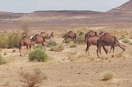
Pour la piste Mhamid-Foum zguid voici les wp du parcours. Celui -ci part un peu avant Mhamid, c'est le trajet rouge et le plus facile au niveau conduite . Il fait environ 150 km, passe en bord d'erg , ensuite au village de Sidi ab n'nebi et suit la piste normale pour Foum-Zguid.
Ces wp sont récents car ils proviennent de la trace que j'ai enregistrée au mois de novembre dernier.
Qui boit l'eau d'une terre étrangère doit en suivre les coutumes (proverbe Mongol)
Salut,
Départ de N'Kob vers 10h
2 Arrets (wisky Berbère)
1 Arret pique nique
Qques arrets photos +pipi
Arrivée à la rte Boulmane Tinghir vers 16h30
Notes:
La piste est sur les traces "Gandini"; Les coordonnées des WPt sont assez bonnes.
La piste est visible sur Google-Earth
Côté sud, en bas, avant les grands lacets, qques maisons avec des gosses "intrépides"
La photo sous mon pseudo à été prise, versant nord, au début des "marches"
A + ?
Razul
Tu m a convaincu de faire la piste rouge donc:) Je vais me bien preparer et de prendre des numeros de telephone de depanage en cas de problem! Merci pour les coordonnes; est ce que tu connait le type du system (UTM ou WGS84). Pour le Hotel Bab Rimal; est ce qu c est le seule dans la region de Foum Zguid.
merci
Merci pour tes info tres pratique. Est ce tu connait si cette piste est sur la map de Olaf Morocco. Je vais emprinter cette piste du versant nord vers le sud; j'envisage le depart just apres midi. J'espere arriver a Nkob avant le coucher de soleil
Merci pour tes info tres pratique. Est ce tu connait si cette piste est sur la map de Olaf Morocco. Je vais emprinter cette piste du versant nord vers le sud; j'envisage le depart just apres midi. J'espere arriver a Nkob avant le coucher de soleil
merci
Salut,
Olaf morocco ?= je ne sais pas.
Pour le reste= Att!!!!!, la nuit tombe très tôt, sans compter une crevaison tjrs possible.
Razul
Je me demande si le trajet de boumalne a Nkoub est possible avec une petite voiture. Sinon, est ce que c est indispensable d'avoir une 4/4. Je compte faire ce trajet le 18 Janvier.
Ce n'est pas un exploit de la faire, mais la piste est quand même caillouteuse et il y a quelques petits passages délicats.
Je pense qu'un 4x4 peut-être vraiment nécessaire... à certains moments.
En ce qui me concerne, je l'ai faite en Duster 4x4 en octobre 2010 et en mai 2012.
Je n'ai pas l'expérience des conditions de circulation en janvier, mais je doute qu'elles soient bonnes.
Bon revenons a la question de chagaga; j'aime bien l'idee de Erg alors je vais essayer de trouver un chemin relativement facile de Mhamid vers FoumZguid en passant tres pres de l'erg; Je vais avoir un 4/4 alors peut si j ai la chance et je trouve un groupe a rejoindre... ca va le faciliter la tache. Sinon, je dois passer un peu de temps avec le garmin pour le maximum de waypoints...
Je t'ai répondu dans le sujet ad-hoc qui est : M'Hamid à Foum Zguid par la piste.
Est il necessaire de prendre un guide pour aller de gite en gite Chemin reperé balise!!! Merci pourvos réponses voyage plusieurs semaines a partir de mai René
Je serais au maroc avec ma copine au mois de juillet et je voulais faire un trek dans le sud marocain à partir d'essaouira ou de ouarzazate, quel est le…
J'aimerais partir faire l’ascension du Toubkal pendant la semaine de Noêl, un petit trek de 3 ou 4j quelqu'un connaitrait un guide ou une agence locale que je…
Nous avons fait une randonnée dans la vallée des roses en août 2019 en famille, un couple et 3 enfants de 10;10 et 13 ans, accompagnés de Lahcen et son équipe.…
Nous allons au Maroc en fin avril et souhaitons faire un trek dans le djebel Sahrho. Connaissez vous un guide ou une agence fiable pour nous accompagner…
Bonjour,
Nous souhaitons faire le trek de 4 jours reliant Mestia à Ushguli sans agence. Il est précisé dans les descriptifs qu'il existe des hébergement à chaque étape, mais on ne trouve pas d'info sur ces hébergements. Quelqu'un a-t-il des infos et un avis sur ce parcours?
We're planning to trek in Peru and Bolivia and would love to find some local agencies.
If you know any, could you share details on prices and, of course, the names of the agencies?
Which trek would you recommend?
Elocine
Je pars en autonomie totale sur un trek au Maroc (10jrs) Imilchil - Aghbalou.
Trouve t-on des cartouches gaz à vis (Coleman, Primus) à Marrakech (adresse) ou villages entre Imilchil - Aghbalou ?
Si non , trouve-t-on des cartouches Butagaz pour camping-gaz (petit volume 230 gr ...)
Merci d' avance pour vos réponses
Hello, I’d like to embark on a little trip in my home country, Switzerland. I’ll start walking from La Cure, heading toward Le Noirmont first, then I’ll improvise my route—but it’ll probably follow the French border... at least as far as Lac de Joux.
I’ll decide day by day how much farther to go after that. My goal is to stay in nature as much as possible, wander around for as long as I can, and restock food in villages or towns along the way.
I’m thinking of mostly camping, but we’ll see if I end up in a hotel or another campsite depending on my route.
I’d love to reach La Chaux-de-Fonds on foot... maybe even Delémont.
The whole thing should take about a week, give or take.
I’ll be bringing my dog, and I’m preparing for this as soon as I’m ready.
Any tips to make sure everything goes smoothly for us? Things I should know—or avoid? What about shepherds with their flocks of sheep? And isn’t hunting season open right now?
I’m not sure if what I’m planning is even doable, which is why I’m asking around.
This’ll be my first time doing something like this—wandering in nature *and* with a dog. I’m really excited for this adventure... and I need it. Thanks!
We’re really keen on ecosystems and want to hike in "natural" ancient forests—not planted woods or areas heavily degraded by human activity. Travel guides (like Lonely Planet) don’t provide much info on this. Could you point us to the most interesting spots?
Thanks in advance for your tips.
We wish you happy holidays and a fantastic 2026, full of discoveries!
Claire and Albert
Hi, this might not be the right section, but I’d like to know if it’s possible to start mountaineering with another person without necessarily hiring a guide. We’ve done quite a bit of hiking but not mountaineering—we’ll just do a half-day glacier course. After that, we were thinking of starting with La Grande Motte and the Pointe de la Traversière, which were recommended to us. Honestly, for things like roping up and knots, I’ll learn at home with lots of videos and a book.
Hi,
I don’t know Switzerland at all and was wondering if Vallée des Joux and especially Dent de Vaulion are packed early in the morning or late in the afternoon in July and September?
If so, do you have any quieter spots to recommend in the area, or in Luxembourg (yes, I know it’s not the same country 😉)?
Thanks a lot!
Jaimerais savoir si quelqu'un aurait fait des treks sur le Ruwenzori et combien ça coute en moyenne, les infrastructures, les paysages la sécurité sur les lieux, merci beaucoup. J'attends avec impatience vos réponses.
We’re leaving in 9 days for a two-week trip to Madeira, mainly to hike.
From my research, I’ve found that since last year, access to most trails—and systematically for the most popular ones—is now paid. You have to pay an access fee of 4.50 € per person per classified hike in 2026, and even 10.50 € for the most iconic hike: Pico Arieiro to Pico Ruivo. When paying, you also have to choose a day and a 30-minute time slot for your start time. Of course, this reservation is neither changeable nor refundable, even if the weather that day is terrible.
Personally, given the massive influx of tourists to the island in recent years, I don’t mind paying a fee to help maintain the trails. Similarly, setting a limit on the number of people who can hike them per day is certainly preferable to preserve this priceless heritage.
However, what’s much less fair is that in reality, most of the available spots are reserved: 1/ for Madeira residents (which is normal); 2/ for "economic operators" (meaning local tour operators). For example, if you’re a non-resident (independent tourist), no booking is possible for the Pico Arieiro hike for an early morning start before September! So, unfortunately, we’ll have to skip this hike.
It’s the same issue for Ponta de São Lourenço, the 25 Fontes, Pico Ruivo... in short, all the most popular hikes. Oh well, we’ll skip those too!
So my question is: which hikes do you recommend where we won’t face the huge crowds that the others get? And where we can book the day before for the next day, taking the weather into account?
Finally, a quick accommodation question: we’ve booked the first week in Funchal, but I haven’t decided yet for the second week. Do you have any advice on where to stay in the south or north, preferably avoiding overly concrete-heavy and touristy spots?
I’m reposting about the logistics for Samaria Gorge.
I’d love to get recent info, especially about whether it’s possible to park my car in Omalos, do the hike, and then catch a bus back to my vehicle.
In theory, it’s doable, but when you check the KTEL website, there aren’t any feasible schedules listed. If anyone has recently organized this with reliable, verified details, I’d really appreciate it. Thanks in advance!
Hi there,
We’re flying from Montreal to Lyon this August to go hiking in the French Alps. We’ve rented a car and will be staying at campgrounds. We’re planning to do day hikes and want to stay a few days in one spot, do a few hikes, then move on to our next camping spot. Could you share your favorite spots or any recommendations for places to spend a few days with great hikes?
A few details:
We arrive in early August and leave in early September.
We’re looking for day hikes (or shorter), moderate difficulty, with a cumulative elevation gain of no more than 1000m, and of course, beautiful scenery!
We’d prefer not to drive too much—maybe it’s best not to head too far south and deal with unnecessary heat?
Along the same lines, if you know of any great campgrounds where we can start our hike directly without needing the car, we’d love to hear your suggestions!
Bonjour
Souhaitant faire de la randonnée sur cette île, je voudrais d'abord savoir quelle serait la période la plus favorable sachant que j'avais passé quelques jours en novembre 2018 pas pour cette activité mais plus pour une simple découverte de l'île et le temps n'était pas top notamment en montagne. Donc peut on choisir une organisation en étoile sachant que je louerai un véhicule avec éventuellement 2 points d'hébergement.
Je n'envisage pas d'intégrer une structure mais de partir à 2 et de s'organiser sauf si vous me conseillez une agence locale ou un guide local. Enfin même si je compte me procurer les différents supports, carte et topo guide plus gps je vous remercie de bien vouloir me communiquer les randos à faire en priorité
Merci beaucoup pour vos informations
I’m planning to do the Mercantour crossing following the Randoxygène route in mid-July.
I’m used to hiking in the mountains, but I sometimes get vertigo, for example on ridges with drops on both sides. I wanted to check if there are any T4 or T3-T4 sections and find out if there are any very exposed passages—and if so, where—so I can plan an alternative route.
Can anyone give me some info on this?
Thanks!
I’m planning a trip around Cap Corse and the AGRIATES in 2026, from May 8th to 15th (there are still 2 spots left, by the way! Just DM me if you're interested).
I’d love to know which hikes are worth prioritizing in the AGRIATES. We’ll be staying in SALECCIA for two days as our base—what should we focus on from there?
A round trip to IGNHU beach? Any other suggestions?
For Ostricano, I think it’s too far for a round trip...
Thanks for your tips!
Have a great day,
Anie, Toulouse
I’d like to get some info about the GR10 Pyrenees traverse. I need help planning the daily stages and accommodations—my wife isn’t an experienced hiker but walks a lot, so I’d like to schedule shorter walking days and thus a longer overall trip in terms of number of days.
Could anyone give me some help and advice?
Best regards,
New to this forum, I’m planning a pretty big project for 2028.
I’m heading to Nepal to do a trek from Kathmandu all the way to Everest Base Camp (a cool 5,300 m 😄).
This trek is a bit special because even though I’ll be part of a group, I’m going solo (so far, no problem—I’m used to it). But it’s my first real trek, and it’s also a humanitarian one: once I reach base camp, I’ll stay an extra week to help clean up the waste left by tens of thousands of climbers! Since I’m originally from South America, from two countries that share the Andes, I have a deep respect for mountains—they fascinate me. So Everest… it’s kind of the trip of a lifetime!
So, a little question for those who’ve done treks to Everest before… any tips for good mental preparation (I’m already working on the physical side)?
Hi there, I’m planning the Annapurna Circuit for March 2027 and I’m looking for a local agency with a local guide—preferably French-speaking—to arrange this trek for us. Any suggestions? Thanks
Hello!
We’re spending a few days in Toraja country at the end of May. We’d love to do a day trek—taking our time—on a route that’s stunning in terms of scenery, but not a level 5 in difficulty!
Any suggestions you can share, please?
Thanks in advance
I’d like to do the Mare a Mare Sud in May over 4 days. I’ve found quite a few places to stay along the route, but I’m stuck on the start and finish.
I’ll be arriving by plane on Sunday evening and would like to start pretty early on Monday morning. Ideally, accommodation right at the trailhead (Alzu di Gallina) would be amazing, but I can’t find anything. Any tips?
Also, for the transfer from Figari Airport to Porto Vecchio or Alzu di Gallina?
At the end, I’d like to pick up a rental car—any advice on that too?
I’m traveling solo by plane to Catania in May and plan to hike the northern side of Etna, starting from Linguaglossa where I’ll arrive by bus. After that, I’d love some info on how to get up to Piano Provenzana (shuttles or hitchhiking), since it seems there’s no public transport except in the summer. Can you sleep there in a free or cheap refuge, or camp? And how far up can you go without having to hire a guide? Thanks in advance. Bernard.
Bonjour a tous,
je pars en voyage au Maroc en aout et nous allons commencer par nous arrêter a Chefchaouen(nous sommes en voiture).
Ma question: quelqu'un peut il m'indiquer un itinéraire de rando en boucle d'entre 5 et 7 jours aux départ de Chefchaouen dans le parc de Talassemtane passant si possible par le pont de dieux?Ou un guide papier qui en reunis quelques uns?
Nous privilégions le camping sauvage et les gites.
Merci d'avance
Hi there, for those who’ve been recently—is it possible to find other solo travelers in March on the island to share transport or room costs? It doesn’t seem easy to travel on a budget.
If you have any recommendations for simple lodgings or places with dorms, I’d love to hear them.
For those who’ve done multi-day treks while moving around: do you need to bring your own sleeping bag? I’d love to hear about itineraries you’ve done without a guide, just with a map and GPS.
Thanks, and have a great day!
Hi everyone!
We’re planning a 15-day road trip to Scotland this summer, specifically to explore and hike on Lewis and Harris—places we’ve never been before. We’ve visited other islands on previous road trips in Scotland (we usually go in April for a week). This would be our first time in Scotland in the summer and for 15 days. We’re looking at late August to early September.
I’m currently drafting the itinerary. We’d be crossing from Ullapool and were thinking of spending 3 nights on Harris and 4 nights on Lewis.
Does that sound balanced to you? Is it better to keep the same accommodation on Harris and the same on Lewis to explore the area? I’d love to hear about any past experiences you’ve had on these islands.
Thanks!
Hi there, I’m trying to leave for 15 days very soon to São Vicente. I’m either looking to join an agency or figure things out on my own to go hiking on one of these islands or both. From what I’ve seen, it’s not easy to organize with local transport, so it gets expensive. Can I use the services of a small local agency? I’m looking for the simplest way to hike for several days. Also, how do you get from São Vicente to São Nicolau? Thanks in advance and have a great day!
Aichatou
I’ve been wanting to do this for several years, and this year’s the one. Next September, I’ll be trekking in Tusheti (Georgia), from Omalo to Shatili.
Of course, I won’t be renting a vehicle that’d just sit unused. No problem getting to Pshaveli, but from there to Omalo, it’s a dirt road (still the case?)
There must be some form of public transport since there are so many guesthouses, and not all travelers come in a 4x4.
If any of you have been to Omalo, could you confirm that these shared transports exist and how often they run?
we’re planning a trip to Yellowstone and hoping to do a three-day backcountry hike if we get a permit.
if any of you have done this before, could you let me know if it’s possible to find water along the way? And if we can transport it, are we allowed to use a stove?
Hello,
I’ll be in Nepal from March 6th to 29th (we’re flying into Kathmandu via Varanasi and leaving via Delhi).
I’m a bit confused about the regulations requiring a guide.
My wife and I (we’re 63 and 64) aren’t experienced trekkers—we’re more used to walking on terrain with very moderate elevation changes. I’m looking for fairly easy hikes, possibly day trips.
Here are my questions:
- Does the Poon Hill trek from Pokhara require a guide, or is it better to go through a local agency? (I’ve seen a lot of them offering 4-day packages)
- I’d like to do a few multi-day hikes around Jomsom (Kagbeni, Mukitinath, Lupra, Marpha)... Do you need a guide for those, and can you find accommodations easily without booking in advance?
Last question—I’m really hesitant to lug around a sleeping bag or down jacket during our 6 weeks in India. Can you easily find these kinds of items at reasonable prices in Pokhara?
Thanks in advance for any tips you can share!
Yann