Bonjour les cyclos!
Nous sommes un couple avec 3 filles de 2, 5 et 7 ans et nous voyageons à vélo depuis la naissance de notre première fille. A Noel dernier, nous avons fait la Thaïlande : nous avons longé la côte est pendant 800 kms, entre Bangkok et Surat Thani. C’était top : superbes paysages, tout plat, et très peu de touristes (à part à Hua Hin). Pour ce noel, on souhaite repartir en Asie. On hésite entre retourner en Thaïlande faire la côte ouest ou bien un autre pays comme le Laos. Nos critères de choix : peu de touristes, conditions sanitaires correctes (nous ne sommes pas exigeants, mais il faut veiller à la santé des enfants. La Thaïlande c’était le grand luxe!), et surtout un itinéraire PLAT. Nous comptons rouler 700 à 800 kms en 3 à 4 semaines. Que nous conseilleriez vous?
Merci!
www.lafamillecyclotouriste.blogspot.com
Bonjour la famille
alors au nord de Vientiane c'est pas trop montagneux jusque Vang vieng environ 180km juste des collines
apres vers le nord jusque Luang prabang environ 275km ça monte jusque 1400m et redescend jusque 400m donc plus dur
ensuite encore 450km jusqu'à la frontiere thailandais moins dur mais pas vraiment plat
vers le sud au depart de Ventiane c'est c'est plat mais pas drole a vélo surtout pas avec des enfants 685km de route quasi rectiligne avec de la circulation jusque pakse
voila a vous de voir bonne vacances
bernard
bjr
puisque vous etes alle seulement jusqu a surat thani (et probablement en suivant en partie l autoroute tres tres frequentee ?)
alors vous trouverez la partie de la meme cote plus au sud et les paysages et les gens magnifiques
khanom nakhon si thammarat taloom phlu puis descendre vers phatthalung le lac de songkhla et toutes les communautes autour du lac du cote de ranot
vous avez matiere a y passer 1 ou 2 semaines
puis la partie sud du lac de sonkhla hatyai
ensuite traversez plein ouest avec soit le passage a travers les collines
et passez soit a la hauteur dw Trang soit a hauteur de Satun
et la cote voire une petite escapade sur les iles
et les reliefs extraordinaires de pics karstiques comme ceux de la baie de phuket phangnga
Nos critères de choix :
1)peu de touristes bonne pioche tant au laos qu au cambodge
2)conditions sanitaires correctes (nous ne sommes pas exigeants, mais il faut veiller à la santé des enfants. La Thaïlande c’était le grand luxe!) mauvaise pioche: moins facile de trouver des piaules qui ne sont pas des taudis (meme en allongeant plus de $), du paludisme bien plus present, une nourriture moins safe qu en thailande, au niveau bestioles, il y en a un peu plus plus dans les coins paumés
3) et surtout un itinéraire PLAT. mauvaise pioche pour le laos sauf à longer le mekong, et pas tres bonne pioche au cambodge, pour les deux pays, l etat du resau routier est a des km en dessous de la thailande, avec des morceaux de pistes partout qu on peut dire sans trop exagerer infranchissables avec des gosses des qu il a plu un peu
4) j imagine que vous avez loue des velos a bkk, puis que vous les avez ramene en train ou en bus. ce sera probablement un peu moins simple au cambodge et au laos, de louer, mais aussi de gerer le retour. dans ces deux pays, la circulation n est pas vraiment dense, mais elle est quasiment integralement concentree sur les rares axes routiers pratiquables, ce qui revient au meme qu en thailande au niveau frequentation, mais avec des nids de poule et d autruche qui rendent les routes autant voire plus dangereuses
si tu retournes en thailande, tes filles vont finir par baragouiner le thai, ce qui devrait t offrir, à tes enfants mais aussi a vous deux une porte d entree magique chez les gens de la cambrousse
Nous avons traversé il y a quelques mois le Laos, le Cambodge et la Thaïlande; ainsi qu'une partie de la Malaisie.
Comme tu le dis, la Thaïlande c'est le luxe! Et c'est clair que dans les autres pays au nord c'est peut être moins facile au niveau des routes...
Nous avons suivit le Mekong entre Luang Prabang et Phnom Phen et cette portion était vraiment magnifique. Nous avons suivi au maximum les pistes pour avoir le moins de circulation possible et c'était vraiment magnifique. L'une des plus belles que nous avons faites se situe entre Paksé et les 4'000 îles (Laos). Nous sommes d'ailleurs tombés amoureux de Champassak !!!
Bonjour Alban,
Merci pour tes conseils, quelques questions :- Y t'il bcp de dénivelé le long du mekong, de Si Phan Don à Nakhon Phanom?
Trouve t'on des hébergements facilement?
Penses tu que ce côté laotiens est plus intéressant que celui Thaïlandais?
En fait, nous avons 4 semaines, et notre plan serait de pédaler 2 semaines le long du Mékong (pas encore décidé quelle portion, ni quel côté (laos ou Thaïlande), et 2 autres semaines le long de la côte d'Andaman (portion pas encore choisie), avec un déplacement en train entre les 2 semaines.
Nos critères de choix :
- Peu de touristes
- Des hébergements faciles à trouver sans réservation
- Des itinéraires plats et sécuritaires (nous voyageons avec 3 enfants en bas âges).
Que nous conseillerais tu?
Un grand merci pour tes conseils ainsi que ceux d'autres lecteurs potentiels...
Je suis actuellement à Phnom Penh, et je penses partir d'ici 2 jours direction Battambang,
j'hésite encore a sortir de la ville a vélo, ou a prendre le bateau, mais aparement ce n'est pas possible de faire le troncon Phnom Penh>Kompong Chhang sans payer la totalité du trajet qui va jusqu'a Siem Reap soit 35 dollars. Avez vous fait se trajet ? Pouvez vous m'en dire plus ? Merci ! M.
bonjour
j'ai fais cette route a velo et aussi le trajet en bateau avec un velo sur le bateau
la route est une "grand route" avec pas mal de circulation sans interet visuel, plate 300km parfois du vent peu d'ombre
rien a en dire de plus il faut 2 jours il y a 300km
bonne route
le trajet en bateau est tres agreable au depart de PHNOM PENH / beaux paysages et vie lacustre interessante / mais assez rapide....
si tu prends ton temps, la route nationale est dangereuse pendant 30/40 km, ensuite la circulation diminue progressivement et devient supportable.
route plate, souvent en travaux ou trouee ou en mauvais etat (debut 2014) / parfois refaite et agreable /
beaux paysages de plaine de temps en temps, comme partout au Cambodge / assez monotones parfois / beaucoup d'arrets sympas, surtout si tu parles khmer...s'eloigner un peu de la nationale pour mieux respirer et entendre les oiseaux, par exemple.....
a voir : UDONG sa colline sacree et ses vieux temples : belle balade a velo en quittant la nationale avant la ville
si tu roules doucement, compter 3 ou 4 jours
en 2 jours c'est tres fastidieux car tu ne peux pas t'arreter souvent
prudence....
bonne route
Patrice
le vrai voyageur n'a pas de plan établi et n'a pas l'intention d'arriver.
LAO TSEU
Merci pour tes dernieres infos, je vais donc sortir de la ville avec le vélo, pour l'experience bateau je préfere attendre un peu pour avoir l'occase de faire qukeque chose d'un peu moins touristique, car la traversée Phnom penh > Siem Reap doit etre tres fréquentée je pense. Quand tu me dis 3-4 jours, tu parles de l'aller Phnom Penh > Siem Reap en passant pas Battambang ?
Car j'ai vu qu'il y avait plus de 400km, je penses rouler entre 50 et 60km par jour, selon mon acclimatation a la chaleur biensur !! Pour l'instant je trouve qu'il fait tres chaud, mais les gens d'ici me disent que pour eux c'est encore l'hiver, et que ca va continuer a chauffer de plus belle !
Si j'ai bien compris, tu redescend dans le sens inverse toi ? Nous allons sans doute nous croiser.
Au plaisir.
Marion
bonjour Marion
quand je note 3 ou 4 jours, je pense a PHNOM PENH - BATTAMBANG, ...
BATTAMBANG - SIEM REAP : 2 ou 3 jours de plus, selon ta forme.
sauf si tu roules tout le temps, mais je te le deconseille, ce serait dommage, surtout au Cambodge / il y a tant a voir. meme dans les plus petits hameaux..............
quant a la chaleur actuelle, il faut savoir que decembre et janvier sont, sauf erreur, les mois les plus froids de l'annee...
a partir de fevrier les temperatures augmentent et la secheresse qui va avec...
je devrais etre sur la route SAMRAONG / KRALANH le 30 (guest house au carrefour)
et KRALANH / SIEM REAP le 31 decembre au matin/ sauf imprevu
tu ne devrais pas etre trop loin....
au plaisir de te lire
Patrice
le vrai voyageur n'a pas de plan établi et n'a pas l'intention d'arriver.
LAO TSEU
Je suis á Anlong veng ds le nord ouest, il fait juste bon. L'ideal pour le velo.
La route de stung treng (frontiere laos) vers samraong via preah vihear est tout simplement superbe pour qui aime le velo...
Presque pas de trafic, pas de touriste......beaucoup de petits villages sympas..
la route phnom penh - battambang, trop frequentée , de plus en plus de 4x4, taxi, minivan...tous á fond...peut être bien si tu roules tout doucement.
Salut Rodenbach, Oui tu as raisons pour la circulation, je vais reflechir a des itineraires intermediaire, et essayer de m'échaper des axes qui doivent etre tres fatiguant du fait qu'il faut etre sans cesse vigilant à la circulation tres dense.... et moins sympa aussi d'etre sur les axes touristique...
Je reviens vers toi au sujet de la suite de mon itineraire,
me voici arrivee a Siem Reap, par la nh5 qui a mon gout
etait tro frequentee... donc j etudie ma carte pour prendre des routes annexe
en direction de la frontiere du Laos.
Ma question c est au sujet de l orientation,
je n ai ni boussole, ni gps, ni telephone, et je trouve que point de vue reperage cest pas facile ! Les routes annexes ne sont jamais indiquees, et lorsque je demande ma route aux habitants, il sest avere que ca n a pas fonctionne, on me disait toujours OUI OUI C EST PAR LA, mais c etait pas la cas.... me conseils-tu de trouver un telephone avec gps avant de m aventurer sur les petites routes ?
Et 2em question, en passant par ces petites routes, trouverais je a manger partout ? Je ne fai pas de provision, a part qlq biscuit, mais le reste je faisai au jour le jour pour l instant.
Bonjour,
De Siam reap il y a une route vers preah vihear city (via Kulen) et ensuite une route trés peu frequentée vers Stung treng (130 km).
J'ai une trés bonne carte (indochina know how Reise) et 1 tablette (j'utilise OsmAnd....open street map) trés bien, facile...
Un portable c'est chouette, facile, pas cher (au laos j'avais une connection 3 G pour 5 € par mois.....) j'utilise juste pour le net, pas de telephone, et c'est bien agréable, surtout dans les bleds....
sinon, la n5, je l'ai prise pendant 50 km de Kralang vers Sisophon, et c'est vrai , c'est nul.
je suis passé par la ou tu es déjà 2 fois bon c'était en 2005 et 2007
donc certaine routes on été macadamisée
pour demander ton chemin tu dis "paille" et ensuite le nom du village
quand tu sais que ton prochain village est plein "Est" demande en montrant une direction erronée(le nord ou l'ouest) si il te dises oui ben tu sais qu'il y a mal entendu !
et donc tu pars et réessaye plus loin cela n'aide jamais d'insister lorsque le debut est erroné
je sait que tu n'a pas de boussole mais le soleil doit pouvoir t'aider ou essaye d'en trouver une
voici les noms des villages a traverser dans la direction de "stund Trung"
le premier point important est "boeng mealea" il y a la un temple visité par beaucoup de touristes donc c'est connu(il y a meme un poste de garde qui voudront te faire payer l'entrée au temple et qui seront étonné que aille vers "stund Trung")
d'abord sur la nationale qui quitte "siemreap" plein "Est"(le soleil dans les yeux le matin) tu vas jusque environ 17km"roluos" ensuite
soit nord est direction "boeng mealea"
soit 19 km de plus sur la même nationale et tu arrive au carrefour de la route nationale qui mene a "tbeng meanchey" en passant par "boeng mealea"
a boeng mealea tu vas soit plein nord jusque "tbeng meanchey"
soit plein est (ce que j'ai fait)par une route (il la construisait lors de mon dernier passage)vers
"khvav" appelée aussi "O" ou "kwo"29 km (j'ai dormi a "O" les 2 fois dans un endroit différent)
ensuite 33km jusque "ta seng" puis 28km jusque "phnum deik" (c'est un carrefour il y a une ecole
un ptit resto) la tu te retrouve sur la rn qui va plein nord a "tbeng meanchey
la j'ai pris la route vers l'est, a 13km se trouve un gros bourg nommé "rovieng Cheung" avec un vraie guesthouse et un gros marché.
ensuite le lendemain plein nord direction "chep kandal" 70km debut route macadam ensuite c'était une piste dure mais depuis cela a peut etre changé dodo a "chep kandal" faut trouver un hébergement mais ils sont tous pres a gagner un peu de sous
derniere journée 80 km jusque "stund Trung" via "sralau" "khsan" "sam ang" globalement y a plus de risque d'erreur toujours tout droit jusque au Mékong puis le bateau
donc jour 1 jusque "O"; jour 2 jusque "rovieng Cheung"; jour 3 jusque "chep kandal" jour 4 jusque "stund Trung"
il y a de super bon jus de canne frais a boire dans différents village rien que pour cela je le referait
j'espere etre clair sinon y a qu'a redemander et je repete vas y c'est plus dépaysant que les grandes routes
bonne route
Concernant les dénivelés, il n'y a pas grand chose entre les 4'000 îles et la région de Nakhon Phanom. Nous avons beaucoup apprécié entre Paksé et les 4'000 îles où il existe une piste incroyable qui longe le Mékong où seuls les deux roues peuvent passer (pas de touristes). Nous avons également eu un coup de coeur pour Champassak avec Yves, un français qui a relancé l'association du théâtre d'ombres du village. Il y a environ 250 km entre Paksé et les 4000 îles. Après, nous avons pris le bus entre Paksé et Thakhek. La route est très monotone et assez dangereuse. Il n'y a pas de piste pour l'éviter...
Si vous ne souhaitez pas vous embêter avec le bus, il y a moyen de faire une jolie boucle dans le plateau des Boloven, au nord-est de Paksé. C'est un plateau magnifique avec des cascades incroyables! NOus l'avions fait en scooter car on était avec une amie mais à vélo, ça doit être génial... PAr contre, à voir au niveau des dénivelés... Le mieux est de jeter un coup d’œil sur le site "openrunner" où tu peux calculer les dénivelés entre deux villes. C?est bien pratique si on ne veut pas de mauvaises surprises...
Après, avoir des hébergements faciles à trouver sans avoir trop de touristes, c'est assez compliqué... Quand il y a des auberges, il y a des tousites. A part Champassak où nous sommes restés une semaine sans voir trop de monde, il y a bcp de touristes en asie du sud est en général... Pensez-vous prendre une tente ? ça simplifie bien et le bivouac se fait facilement dans cette région. Nous avons planté la tente à plusieurs reprises dans les cours d'école (il y a tjs un point d'eau) et c'était génial; surtout avec vos enfants qui se ferons une joie de jouer avec les enfants de l'école.
Si tu as d'autres questions, n'hésites pas... J'y répondrais un peu plus rapidement!
Alban
Découvrez notre voyage en tandem pino hase sur
www.lattitudeterre.com
bonjour nous partons avec nos filles de 1 et 4 ans et si vous etes toujours en velo quelque part, nous aimerions faire votre connaissance. nous allons chercher a acheter des velos a notre arrivee le 5/1/15.
nous emmenons en revanche notre cariole et nos sacoches.
au plaisir de vous lire
aurelia et sebastien
Merci Ben ! Cest tres gentil toutes ces precisions, autant du point de vue orientation (avec le soleil cest sur je ny avais pas songe!) que pour les infos sur les routes et les coins ou dormir... je n hesite plus maintenant ! Ya plus qu a foncer, tu m as fait rever d avance !! Tu te souviens avec precisions d ailleurs, ca m epate !
Au plaisir. Marion
pas de mal pour l'erreur nous sommes des belges, mais fais pas ça avec des français ho
j'espere que tu as put noter le nom des bleds ou imprimer le mail
bon pour la suite si tu le desire et en a le temps
apres les 4000 iles au Laos je sais aussi te faire un roadbook pareil a celui que je t'ai fais pour le nord Cambodge
enfin on verra a ton arrivée a stund treng mais la remontée du Laos a l'interieur des terres sauvages fut particulièrement mémorable
donc Rodenbach précise qu'il y a un pont pour franchir le Mékong en fin de parcours (il était en construction lors de mon dernier passage, maintenant je m'en souviens dur dur de vieillir)
bonne route
bernard
Nous avons le mois de novembre 2016 devant nous et nous souhaitons effectuer un voyage à vélo dans l'Asie du Sud Est. Nous sommes sportifs et complètement…
Je pars pour un mois minimum de velo a travers l asie du sud est. Laos vietnam cambodge thailande. Je voulais savoir si certaine personne avaient des infos sir…
Je pars en octobre (7) de Bangkok directe vers Siemp Reap, puis vers le Laos du sud au nord et redescente vers Bangkok. Pas d 'itinéraire établie juste un…
Je viens de rentrer d'un périple de 8 mois en vélo électrique en Asie du Sud Est. Ayant passablement posé de questions sur ce forum, je trouvais normal de vous…
Bonjour
quelles sont les moyen les plus simple pour revenir du Cap Nord sans pédaler
train, Bateau, avion ?
qui à déjà fait l’expérience ?
Merci de nous renseigner
17 days, 1,400 km, and 17,500 m of elevation gain cycling in northern Vietnam! 🇻🇳 🚴🇻🇳
From the misty Fansipan to the breathtaking landscapes of the Ha Giang Loop, from remote villages to vibrant markets...
I cycled through the north of the country, getting up close with its people—through mud, heat, endless mountain passes, and unforgettable encounters.
Most importantly, I discovered a Vietnam far different from the usual tourist circuits.
Join me on this adventure through a video that captures these 17 days of travel. :)
If Vietnam calls to you, come ride a stretch with me!
Bonjour,
Je dois arriver en vélo à Thessalonique à la fin Septembre et je prévois de rejoindre Istambul par la côte.
Quelqu'un pourrait m'aider à choisir la meilleure route.Sécurité, difficulté.
Merci d'avance.
Marc
Hi,
can anyone give us some tips on how to get to North Cape from Lyon Gerland?
What’s the best route to join the EuroVelo 7?
How many kilometers is it from Lyon to North Cape via EuroVelo 7?
The best month to leave—we’re thinking early May.
Thanks for any advice!
Looking for a female travel companion for a cycling trip (arriving by plane in Porto Alegre, Brazil, and cycling toward Montevideo, Uruguay, returning by plane to France from Buenos Aires, Argentina) – 1,500 km
Hello everyone!
I’m planning a cycling trip across Brazil, Uruguay, and Argentina, with a departure set for late October, November, or December. I’m looking for a travel companion to share this long-distance adventure with.
Experience:
I already have solid experience in bicycle touring in Georgia, Kazakhstan, and Kyrgyzstan. Currently, I maintain excellent physical condition by cycling an average of 250 km over 3 days per week (4 hours a day at 20 km/h).
The trip & the pace:
Daily pace: Between 50 and 80 km per day, to make steady progress while taking time to explore.
Accommodation: Flexible and authentic. We’ll alternate between wild camping, campsites, Warmshowers, small guesthouses, and budget hotels depending on opportunities and the weather.
Looking forward to reading your message and planning this amazing journey together!
I’m planning to leave Nice for Toulouse around 10/15 and I’m looking for tips / great deals regarding:
- The route: I was thinking of taking Nice - Grasse - Draguignan - Salernes - Cadarache - Cavaillon - Arles, then the Camargue, Sète, and the Canal du Midi to Toulouse. The idea is to avoid high-traffic roads and too many steep climbs. Are there any spots to avoid or must-see stops? Since it’s been a while since I’ve been on the road, I was thinking that sleeping indoors might be preferable. If you have any budget-friendly accommodation suggestions along part of the route, don’t hesitate!
Thanks in advance, and if you’re in the area around that time, we could ride together... Ciao.
Another long-time dream of Claudio’s: the Petit Mont Cenis pass and the dam at the eponymous lake.
A place where many Italians, including my father, worked in the 1950s–60s.
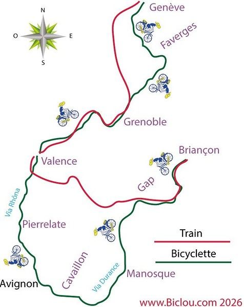
Faverges → St-Michel-de-Maurienne → Lanslebourg → Petit Mont Cenis → return. 315 km, 3 days. Bivouac at St-Michel-de-M.
Brouter link
Leg One: Faverges → St-Michel-de-Maurienne
Leg Two: St-Michel → Lanslebourg → Mont Cenis Lake → St-Michel
Leg Three: St-Michel → Faverges
And it finally happened in August 2026: in the Maurienne Valley about the famous cycle route known as the V67
🇷🇼 Cycling in Rwanda: 4 episodes, an off-the-beaten-path adventure
After 3 weeks and nearly 1,200 km by bike across Rwanda, I made 4 videos to share this adventure in a different way: the landscapes, the encounters, the villages… but above all, all those incredible scenes of everyday life.
The 4 episodes are available here:
👉 https://www.youtube.com/playlist?list=PLGnfbxjccWAg
The 4th episode focuses on rural Rwandan life: simple, authentic, and sometimes surprising scenes that you only truly discover when you take the time to travel by bike.
If you have a few minutes, let yourself be transported to Rwanda…
Hi, I'm looking for info on cycling to Nordkapp via the EuroVelo 7. Has anyone done it already, and where’s the best place to start the EuroVelo 7?
Thanks
Hi,
We bought the MSR bike tent model (2-person + large awning that can fit 2 bikes) back in 2005. It’s served us really well, especially during a year-long trip in Africa. Now, one of the poles is broken, and we’d love to replace it since that’s the only issue with the tent—we still love it! The poles are 9.35 mm in diameter, with 8 sections of 49 cm and 2 sections of 28 cm. Total length when assembled: 416 cm. Actually, two large sections are broken: one straight and one curved. It’s a pain to find replacements since this model is no longer sold anywhere.
Would anyone have this model lying around unused and be willing to sell me a pole?
Hi everyone,
In early April, I’m redoing the Vélo Francette (La Rochelle to Ouistreham), and then I’d like to cycle along the Cotentin Peninsula (which I don’t know at all), follow the coast up to Cherbourg, and then head back down to at least Saint-Malo. I’d love to know if it’s pleasant for cycling—are the roads nice? Not too windy? What are the must-see spots? Any great campsites? All your tips and advice are more than welcome, and I thank you in advance.
Hi there,
I’m planning to bike to meet some friends in Côte d’Ivoire in early November.
I’ll be starting in Abidjan and heading to Abengourou, which is close to the Ghana border.
I’d like to take the trails. Does anyone have recent info on eastern Côte d’Ivoire?
Any tips, safety advice, or must-see stops? I’m open to all suggestions.
Thanks in advance for your help!
Fx
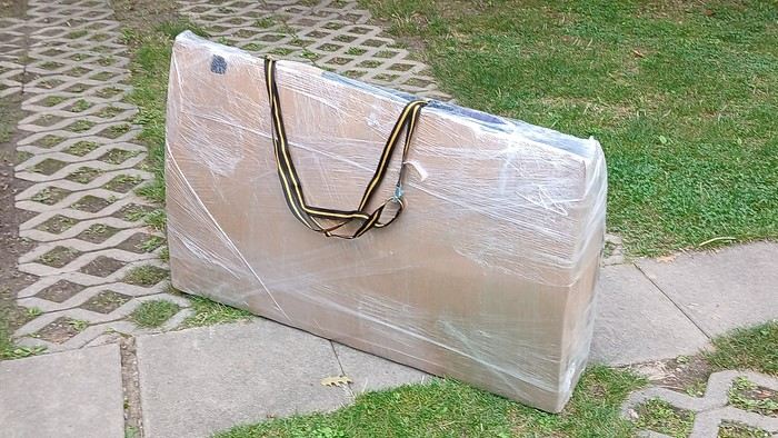
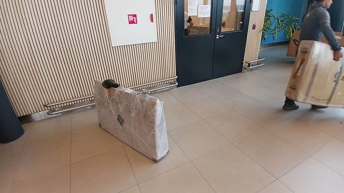
After testing it for three years across various modes of transport, I’m sharing this video of a bike packing case. It’s made from recycled cardboard and shrink-wrapped, with adjustable thickness and added bubble wrap depending on the level of protection you want.
Installing spacers at the fork and chainstays makes the packaging compact. With the fifteen-odd euros for shrink-wrapping at the airport, this case travels really well.
https://youtu.be/_GDJi-GqmkM
- Low bulk (1.10m x 0.70m x 0.25m for a large frame), it fits vertically in train luggage compartments and the total dimensions (x+y+z) don’t exceed 2.40m.
- Two carrying solutions for public transport and easy handling by airport staff (no more tears in the cardboard from openings).
- Discreet packaging when dealing with bus drivers and train conductors, as it looks like an ordinary parcel.
- No need to return to the starting point to retrieve the case from your outbound trip, which you’d otherwise have to store somewhere, or deal with a bulky cover to pack in your panniers.
- You can still check tire pressure through the plastic film without damaging the packaging too much.
Drawbacks: Around 3 hours for this lengthy and meticulous process—removing the wheels, pedals, handlebars, and derailleur without misaligning them, then securing all components to the frame.
If you get a chance to test it, send me your feedback for future improvements.
I just took a trip in Tunisia from Tozeur to Douz, skirting Chott el Jerid to the south. I’m back with the urge to keep going further south via the 4x4 tracks to connect Douz to Ksar Ghilane. Has anyone driven this route recently or explored southern Tunisia?
Thanks for your tips!
fix
😎Fellow traveling cyclists or not, all of you who love travel, the pleasure of physical effort, nature, beautiful machines, people with true passions they seek to fulfill, and who also enjoy reading great literature about all this—the *200* magazine is for you just as it is for me. I should mention I have no financial or other interest in this (in an era where we accuse our politicians of all sorts of vile interests, I prefer to take precautions). I’ve been subscribed since the beginning, and every three months, I get my 130 pages of dreams (the magazine just went from 110 to 130 pages).
It covers everything from the trans-America route to the TCR (Trans Continental Race) from Belgium to a small town in Turkey, with mind-blowing averages—4,000 km and 80,000 m of elevation gain in 8 days and 15 hours for the winner. Let that sink in, and all of it without assistance—accepting a patch could penalize you. There’s also a story about crossing Iran, encountering one of the world’s most welcoming populations, following in the footsteps of Nicolas Bouvier, as well as retirees leisurely traversing France. The common thread in all these stories? Beautiful writing. Take, for example, a stunning article: *"Passengers of the Cold: From Edinburgh to Thurso, at the very north of Scotland, 550 km of moors, coasts, and icy wind. In Thurso, the road ends at a quay, facing the Orkney Islands. We wanted a November trip, off-season. We wanted to surprise winter. Just before the snow."* A sublime piece on the experience of facing adversity and the chance encounters along the road and in the elements.
Before I embarked on my own bike trips, I dreamed a lot about them—from the Atacama to the Gobi, along the Mekong, and not forgetting France. And now, these 130 pages every quarter keep those dreamy vibes alive through stories written in the most beautiful prose.
I’ll stop here because it might sound like I’m advertising, but if you don’t know *200*, I invite you to discover it. It’ll give you wings for the most incredible challenges or simply reinforce your desire for slow rides with your eyes open to others and nature.
A little news to wrap up: Axel Carion and a friend just broke the record for crossing South America from Colombia to Ushuaia in 59 days. On its own, that doesn’t mean much, but I can’t help it—it makes me dream. You should see how he talks about it, the flashes of that wild nature he’s stored away: a snowstorm at Paso Jama and the surreal sight of the suddenly snow-covered Licancabur!
Luc
PS: The magazine is called *200* because a day’s ride starts at 200 km—well, I’ve never done a ride like that since my longest was 167 km (with 18 kg of luggage, mind you), but why not one day? The magazine will explain how to tackle your first 200, and then the question in conclusion: when will you do your first 300?😏
I’ve got my flight ticket sorted—departing in mid-November and returning in mid-March. I’ll arrive in Santiago and leave from Buenos Aires.
I’ve already been to southern Argentina, specifically Torres del Paine National Park, and I’d love to go back to do the full W trek (I only did the shorter version last time).
I also want to do some hiking and maybe even tackle a summit. I climb and occasionally do some mountaineering, so I’ll definitely be going with a guide.
I plan to start around Temuco in Chile, with the idea of heading toward the lakes, then taking the Carretera Austral.
I’m not sure if I’ll go all the way to Ushuaia—it’s supposed to not be *that* worth it, except for the bragging rights of saying you’ve been to the end of the world.
I saw there are lakes in Argentina too.
I don’t have a precise itinerary, but what I’d love is, once I reach the southernmost point of my trip, to take a mini-cruise to see some wildlife. Any tips for that?
What kind of sleeping bag did you take? Is a 0°C (32°F) one enough?
And one last question: white gas stove or can I get by with my gas stove?
I'm developing a free and open-source web app for planning walking and cycling trips (and even car trips). You can create a route by clicking directly on the map to add waypoints, and it can consist of multiple stages. The app provides tools to edit the stages and the overall route, and to display useful information (distances, altitudes, and elevation changes). A relief profile can be shown as a graph for a specific stage or the entire route.
Once the route is ready, it can be exported as a GPX file, which can then be used with a GPS or a mobile navigation app.
The app is built in JavaScript and runs entirely in the web browser. It uses the Leaflet library and several OpenStreetMap-based services. Initially developed for my personal needs (I enjoy hiking and cycle touring), I’d be happy to share it with anyone who might find it useful. It’s free to use, doesn’t require an account, and the source code is available.
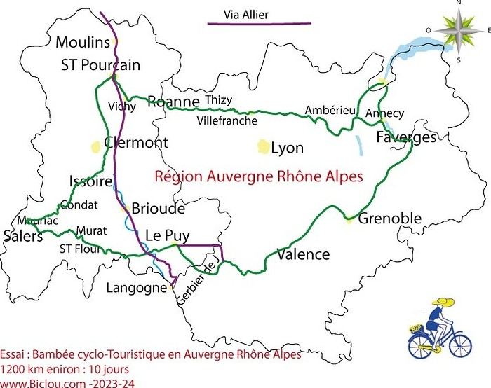
hello fellow cycling enthusiasts
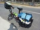
here’s a travel journal of the cycling tour through the Rhône-Alpes Auvergne region by Claudio
zouli
it was the plan
http://cbandiera.free.fr/parcours/auvergne-Ralpes/
the trip was completed
story being posted online soon
1100 km in 11 days
beautiful and varied regions
Hello,
We’d like to go on a 3- to 4-month bike trip starting in December, crossing from Assam (northeast India) to New Delhi via Nepal.
Are there routes with light traffic along the Brahmaputra and through Nepal?
We’re also looking for any info on accommodations, wild camping, local interactions, etc.
Thanks,
Michel
I’m planning to cycle from Morlaix to Brest (via Roscoff and the V45 coastal route). We’ll start riding on August 16th for 13 days (with stops for island visits, surfing, etc.). Is there a lot of traffic at this time of year? I’ve got two kids, 11 and 13, and we don’t like riding in the middle of cars (we’ve already done the Vélomaritime—Caen to Cherbourg—the Loire route from Orléans to Saumur, the Vélodyssée from Nantes to Royans, and the canals like the Nivernais and Bourgogne, where there were plenty of bike-only lanes, which isn’t the case on this route).
Thanks for your help if you’ve already done this route in late August!
Virginie
Hi there,
I’ve been road cycling for several years, and I’m about to switch to gravel in the next few days—I’m waiting for my bike, which should arrive this week.
I’m planning a bikepacking trip in a few weeks along the Véloroute V81, also known as the Vélosud, from Biarritz to Le Barcarès.
Has anyone here already done this route? Any info is welcome, whether it’s about the route itself, gear, or accommodation. I’ll prioritize staying with locals as much as possible. On that note, I just signed up for the brand-new site *Guidon et Couette* ((www.guidon-et-couette.fr)), which offers free accommodation between cyclists across the country, but there’s almost no one listed along my route!
Thanks in advance.
Laurent.
Hi there, I’m planning a cross-Canada bike trip, and I’ve got a question that might seem silly, but could someone tell me how to pack a bike (in a box, with a fragile sticker... I don’t know) for a flight? Thanks in advance!
This summer, we’re planning to cycle along the EV 19 that follows the Meuse River from Langres all the way to Rotterdam.
My question is about getting back to Nantes.
Do any of you know what the best return option might be? I’d love to hear about your experiences.
I saw that FlixBus doesn’t take bikes.
By train, I think it’s possible but would involve multiple local trains.
We were also wondering if there’s a boat from Rotterdam to Saint-Nazaire that could take passengers with bikes.
Any tips or experiences you can share would be really helpful—thanks in advance!
Have a great evening
I’ve gotten used to crossing Europe by bus to return by bike.
It was really convenient to take the bike without having to disassemble it.
But FlixBus no longer accepts bikes...
What alternatives do you know about?
Thanks.
Hi there,
I’m planning to ride the Dutch section of the EuroVelo 19, from Maastricht to Rotterdam.
Since it’s too complicated to bring my bike on the train, I’m looking to rent one locally.
I’d love any tips or bike rental shop recommendations—I’m struggling to find options even in Rotterdam.
The plan is to rent in Rotterdam, take the train to Maastricht with the bike, then cycle back to Rotterdam.
Thanks in advance for any advice or suggestions!
Nath
I’m planning to build a new touring bike.
I want to prioritize lightness.
That said, I’m tempted by a suspension fork that could offer some comfort on rougher roads.
The recent appearance of gravel suspension forks on the market might meet my needs—at least on paper.
I’m particularly considering the RockShox Rudy Ultimate XPLR fork.
Unlike MTB forks, its travel is short: either 30 mm or 40 mm.
It weighs 1400 g, which is 400/500 g more than a steel fork.
Any thoughts or real-world feedback on this?
I’m also wondering about the durability of magnesium (lower leg) for long-distance bike touring.
And what’s the impact of skipping the manufacturer-recommended maintenance every 50 and 200 hours? That’s bound to happen on a long trip unless you carry extra gear.
More generally, how reliable are these kinds of forks?