bonjour a vous tous
je voudrais savoir si une personne ayant fais le tour de l annapurna ou etant monté au camp de base de l'everest seul pourrai me donner son itineraire.
merci d avance.fred
Namasté
Nous avons fait le Tour des Annapurnas sans guide mais avec 2 porteurs pour 4.
Le chemin est très bien marqué sans difficultés si ce n'est l'adaptation à l'altitude.
Passage du col sans vent avec un soleil radieux ...mais la montagne ça peut vite changer...
Un peu froid la nuit aux 2 dernières étapes.
Si tes finances te le permettent prends un porteur ça permet de redistribuer
pour faire vivre une famille (sans pour cela ne rien porter....)
Penser au pourboire !!!
Tu trouveras un topo au Vieux Campeur ou Voyageurs du Monde ... ou à KTM en arrivant
Aucun problème pour les lodges : Tu t'arrêtes quand tu veux sans réserver !!
Bon trek .... c'est divin 😇
coucou!
on a fait le tour des annapurnas en 2003 et le langtang-helambu (au dessus de ktm, beaucoup moins touristique que les annapurnas .le contact avec les gens m'a semblé plus facile).
pas de porteurs, pas de guides...tout compris dodo + bouffe /jour pour une personne environ 40fr, avec petits extras😊
pas besoin de tentes ni de rechauds, puisque tu marches de villages en villages😉
pour les annapurnas pas de soucy, par contre pour l'helambu on s'est un peu perdu...🤪
pour les itinéraires, je te conseille la carte des annapurnas du national geographic...sinon tu en trouves à ktm dans 30/40fr...
euh je cherche un post où j'avais noté notre itinéraire..
à toute🙂
Népal, Inde, Roumanie, Kirghizistan, Irlande, Asie Centrale via la Turquie et l'Iran en mercedes 310D James Cook, le tout en famille
Namasté
C'est encore moi... pour l'itinéraire pour le tour des Anna :
KTM / Besisahar / Bhulbule
Bhubule / Ghermu
Ghermu / Tal
Tal / Lata Marang ( ça monte) vue sur le Manaslu
Lata Marang / Chame ( lodge super Marshyangdi Mandala) et source chaude
Chame / Upper Pisang (Annapurna Hotel) vue sur Anna 2 et Anna 4 et moisson
Upper Pisang / Manang (2 jours + rando vers le lac et la moraine du glacier)
Manang / Letdar
Letdar / High Camp
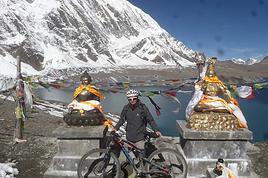
High Camp 6 AM / Thorung La / Muktinath ( belle étape )
Muktinath / Kagbeni ( Mid Western Lodge) et vue Nilgiri
Kagbeni / Marpha ( trop touristique)
Marpha / Lete
Lete / Tatopani ( source chaude )
Ensuite tu termines à Beni ou tu continues vers Poon Hill, Ghandruk
A + Chantal
alors pour les annapurnas départ de bésisahar.mais il y a trois ans ils construisaient une route jusqu'a presque khudi.
donc étapes courtes environ 5h de marches par jour.
zen quoi, sans se presser 21j au total .
bésisahar-khudi.................790m
petit village, chaleur+++++++++, dodo dans un lodge a coté de la riviere qui fait un bruit du tonerre.douche froide ..le nom du lodge??(mon carnet de voyage est dans mes cartons de déménagement😎😎😎)
khudi-bahundunda ............1310m
ouahouh la montée dure++++++++, du coup on reste deux nuits petits dérangement intestinal🤪
bahundunda-jagat ............1300m
me rappelle plus trop??😠
jagat-tal..........................1700m
petit dalbhat excellent avant tal à sattale, dans une petite famille où il y a deux enfants...je leur avais donner des coquillages !!!😇
tal village un peu du farwest, lol...
tal-bagarchap...................2160m
sais plus trop non plus😠, mais papottage avec un danois 😄
bagarchap-chame..............2600m
on voit une avalanche en face du lodge sur l'annapurna2??!! petite epicerie où il y a meme des pellicules photos
chame-pisang...................3300m
une des rares journées, de "plat" .super joli !!!dodo a lower pisang, mais balade à upper pisang.
pisang-manang..................3540m
trop chouette, bien qu'un peu 'big village".balade au lac....2dodos, car acclimatation obligée pour le col...
manang-yak karka..............4018m
bouhhhhhhhh, ca caille la nuit!!!!!le paysage est trop trop beau !!
yak karka-high camp...........4800m
dur, je suis pas bien du tout 😕mais on continue, on prend un porteur pour porter mon sac (13kg pour lr jour du col /1300rpn!contre 400rpn je crois si tu en "prends" un des le début du trek)
tu peux stopper à thorung phedi mais bon, là high camp te rapproche du "terrible"
high camp -mukhtinath........3800m
bouhhhhhhhh, dur, on monte pendant bien 3h, avec peu de souffle, et on descend pendant 5h:1600m de dénivellé..😮toujours pas tres bien.
muktinath-kagbeni..............2800m
un bonne sou-soupe a l'ail et on repart, hihihihiihih..(l'ail est bon contre le mal de l'altitude)euh, soi-disant;lol
là on croise un gars de ktm, qui nous demande le chemin de muktinath (lieu de pélerinage hindou )il nous qu'il a economisé tte sa vie pour ce pélerinage, il est trop heureux!🙂
kagbeni-eklobathi...............2740m
oup's on se gourre de chemin alors demi-tour.....mais on est réveillé le matin, par le mec du lodge qui fait ses prieres et rentre ds nos chambres avec son encens en gueulant !!!excellent🙂
eklobati-marpha.................2670m
beau, du vent, du plat
marpha-larjung..................2550m
de la marie-jeanne😊
larjung-kopchepani............?????
un dalbhat suculent et une bonne soirée
kopchepani-ghara.............1700m
dodo dans une famille adorable, je pense qouvent à eux, et à cette petite mémé qui nous faisait la tronche au début.....et à ce bb ....😊
ghara-banthanti...............2300m
une eglise chretienne ???!!!
banthanti-pokhara............FINISHdur dur, quand on est pas sportif pour un clou, mais j'ai hate d'y retourner........;
snif, ca me manque vraiment......
tout du long, une luminosité, des paysages, des gens supers, ahhhhhhhhhhhhhhhhhhh....
voili, si tu as des questions,
ou alors je peux te filer l'itinéraire du langtang ( 15j)
bye, marion
arf,
Népal, Inde, Roumanie, Kirghizistan, Irlande, Asie Centrale via la Turquie et l'Iran en mercedes 310D James Cook, le tout en famille
Namasté
C'est encore moi... pour l'itinéraire pour le tour des Anna :
KTM / Besisahar / Bhulbule
Bhubule / Ghermu
Ghermu / Tal
Tal / Lata Marang ( ça monte) vue sur le Manaslu
Lata Marang / Chame ( lodge super Marshyangdi Mandala) et source chaude
Chame / Upper Pisang (Annapurna Hotel) vue sur Anna 2 et Anna 4 et moisson
Upper Pisang / Manang (2 jours + rando vers le lac et la moraine du glacier)
Manang / Letdar
Letdar / High Camp
High Camp 6 AM / Thorung La / Muktinath ( belle étape )
Muktinath / Kagbeni ( Mid Western Lodge) et vue Nilgiri
Kagbeni / Marpha ( trop touristique)
Marpha / Lete
Lete / Tatopani ( source chaude )
Ensuite tu termines à Beni ou tu continues vers Poon Hill, Ghandruk
A + Chantal
Népal, Inde, Roumanie, Kirghizistan, Irlande, Asie Centrale via la Turquie et l'Iran en mercedes 310D James Cook, le tout en famille
Un guide pour ce treck n'est pas tres utile, par contre un porteur est un grand confort !!!!! Il est tres difficile de se perdre !!!
A +
DHES , C'est mon avis mais je n'ai pas forcement raison ! faire sa propre expérience , c'est quand même le TOP!
Pour les échanges d'enfants sur l'international en bas age ; un site qui mérite le détour : http://www.enfamille.com
Bonjour Pampelichkaa (j'adore ce pseudo).
Nous allons en avril prochain faire un trek (environ 1 semaine) en famille au Népal. Les billets d'avion sont pris, reste à choisir notre trek. Je vois que tu as fait le coin des Annapurna et aussi la région de Langtang Helambu qui à priori m'attire plus car elle semble moins fréquentée. Nous prendrons certainement des porteurs et un guide s'il le faut. Nos enfants auront 11, 12 et 13 ans et sont bons marcheurs (meilleurs que moi...).
Nous ne sommes jamais allés en Himalaya.
Les paysages de Langtang Helambu sont-ils vraiment moins super que ceux des Annapurnas au point de braver la foule de ces derniers?
Que me conseillerais-tu?
Merci pour ton aide.
Marie
Coucou
Oui c'est bien...!!!!
Et le Langtang c'est comment ?? Peut-être un peu moins grandiose ?
Les sommets y sont moins hauts, alors je me demandais si ... Bon on réfléchit !
Es-tu passée par le col de Ganja La ? Combien de jours en autonomie ?
A + Chantal
namaste 😉
le langtang, j'en garde un super souvenir pour les contacts!(80km de ktm, 12h de bus, j'adore🙂)
et puis c'est beaucoup moins fréquenté,
((((pour info, pendant le trek des annapurnas, nous étions 100 environ, à 'pointer' chaque jour ...dans le langtang, pas de 'pointage", mais nous marchions avec 2suisses. c'est tout...donc effectivement, il y a + de contact.))))par contre il y a un exode rural assez important )
les paysages sont super beaux et varié tout de meme.moins de difficultés pour marcher, je pense.
mais les paysages des annapurnas sont à couper le souffle.
après peut etre que j'ai senti ca, car nous avions marché en premier dans les annapurnas(donc découverte des himalayas)en tout cas, le langtang-helumbu (j'insiste bien la-dessus, à ne pas manquer : les lacs gosainkud!!! là c'est époustouflant ! c'est au croisement du langtang -helumbu.
c'est magique et .....beau, quoi!!un col à 4900m si je me souviens bien.
pour le col du ganja, pas pour nous, car là encore il faut 4/5jours d'autonomie )
le langtang, les sommets y sont moins haut, mais on est plus proche du tibet (4/5km) et, je sais pas, ca procure une sensation étrange....peux pas expliquer 😕
mlefevre :tes enfants ont de la chance ! par contre, vous pouvez pas 'trekker" (beuuuuu, j'aime pas ce mot!!) pendant 15jours plutot?? car langtang-helumbu :13/15j.et puis si c'est la premiere fois que vous voyez l'himalaya, vous serez comblés!)
si vous voulez d'autres renseignements, je serais heureuse de me rappeler tout ca encore une fois😉😉😉
marion
Népal, Inde, Roumanie, Kirghizistan, Irlande, Asie Centrale via la Turquie et l'Iran en mercedes 310D James Cook, le tout en famille
lapresse2:
>> (2 jours + rando vers le lac et la moraine du glacier)
Est ce que tu parles du lac de Tilicho en passant par Khangsar ?
J'ai cru lire qu'il fallait compter 3 jours AR depuis Manang... Les photos donnent envie en tout cas (voir cette page).
Salut Pampelichkaa.
15 j de trek me paraissent vraiment longs, je ne sais pas si on tiendrait le coup.
Et puis, il y a l'école (tu verras dans qelques années...), on part un peu avant le début des vac de Pâques et on revient qq jours avant la fin pour récupérer les devoirs (eh, oui!) et se remettre du décalage horaire. Bref, on arrive le 29 mars au matin et on repart le 11 avril au soir. Donc on peut faire un trek d'un peu plus de 8 jours mais guère plus car il faut déjà 1j en arrivant pour établir les permis de trek.
Dis-moi en toute subjectivité où tu emmènerais ton bébé dans quelques années pour lui montrer l'Himalaya pour la première fois?
J'aimerais quand même bien voir de très hauts sommets même de loin....
Au fait, pourquoi cet exode rural du Langtang, en as-tu une idée?
Message reçu pour les lacs Gosainkud!
Merci Marion (c'est le nom de notre petite dernière, un sacré numéro d'ailleurs!)
Marie
J'ai fait cette ballade il y a deja quelque temps avec un collegue de voyage.
On est parti de Pokhara pour Naudanda.Puis Carre, Garopani, Tatopani, birethanti, KakBeni retoir par Beni et Kushma.
L'orthographe des villages est a verifier ainsi que l'ordre sur le trajet.
Une ballage tres tranquille d'environ 3 semaines car on s'est arrete partout ou on etait bien.
Je cherche à avoir des retours d'expériences de gens qui auraient fait le tour des Annapurna récemment et qui pourraient me confirmer qu'il est toujours…
Je désire faire le tour des Annapurnas en mode vraiment lent. Je pars 2 mois et mon premier objectif est ce tour. Je ne suis pas pressée. Je me demandais si…
Je compte partir au Népal courant avril 2013 avec un ami afin de réaliser le grand tour des Annapurnas. Est-il préférable d'engager un guide? Du fait de la…
J'ai lu que bcp font se trek sans guide ni porteur. Est ce facile? Comment cela se passe t'il pour se nourir? Est ce que le "sentier" est bien signalé? Pas de…
Je m’apprête à faire le grand tour des Annapurnas + lac Tilicho seul et sans guide en mois Avril ou Mai 2014, mais d'après mes recherches j'ai trouver qu'une…
Bonjour,
Nous souhaitons faire le trek de 4 jours reliant Mestia à Ushguli sans agence. Il est précisé dans les descriptifs qu'il existe des hébergement à chaque étape, mais on ne trouve pas d'info sur ces hébergements. Quelqu'un a-t-il des infos et un avis sur ce parcours?
We're planning to trek in Peru and Bolivia and would love to find some local agencies.
If you know any, could you share details on prices and, of course, the names of the agencies?
Which trek would you recommend?
Elocine
Je pars en autonomie totale sur un trek au Maroc (10jrs) Imilchil - Aghbalou.
Trouve t-on des cartouches gaz à vis (Coleman, Primus) à Marrakech (adresse) ou villages entre Imilchil - Aghbalou ?
Si non , trouve-t-on des cartouches Butagaz pour camping-gaz (petit volume 230 gr ...)
Merci d' avance pour vos réponses
Hello, I’d like to embark on a little trip in my home country, Switzerland. I’ll start walking from La Cure, heading toward Le Noirmont first, then I’ll improvise my route—but it’ll probably follow the French border... at least as far as Lac de Joux.
I’ll decide day by day how much farther to go after that. My goal is to stay in nature as much as possible, wander around for as long as I can, and restock food in villages or towns along the way.
I’m thinking of mostly camping, but we’ll see if I end up in a hotel or another campsite depending on my route.
I’d love to reach La Chaux-de-Fonds on foot... maybe even Delémont.
The whole thing should take about a week, give or take.
I’ll be bringing my dog, and I’m preparing for this as soon as I’m ready.
Any tips to make sure everything goes smoothly for us? Things I should know—or avoid? What about shepherds with their flocks of sheep? And isn’t hunting season open right now?
I’m not sure if what I’m planning is even doable, which is why I’m asking around.
This’ll be my first time doing something like this—wandering in nature *and* with a dog. I’m really excited for this adventure... and I need it. Thanks!
We’re really keen on ecosystems and want to hike in "natural" ancient forests—not planted woods or areas heavily degraded by human activity. Travel guides (like Lonely Planet) don’t provide much info on this. Could you point us to the most interesting spots?
Thanks in advance for your tips.
We wish you happy holidays and a fantastic 2026, full of discoveries!
Claire and Albert
Hi, this might not be the right section, but I’d like to know if it’s possible to start mountaineering with another person without necessarily hiring a guide. We’ve done quite a bit of hiking but not mountaineering—we’ll just do a half-day glacier course. After that, we were thinking of starting with La Grande Motte and the Pointe de la Traversière, which were recommended to us. Honestly, for things like roping up and knots, I’ll learn at home with lots of videos and a book.
Hi,
I don’t know Switzerland at all and was wondering if Vallée des Joux and especially Dent de Vaulion are packed early in the morning or late in the afternoon in July and September?
If so, do you have any quieter spots to recommend in the area, or in Luxembourg (yes, I know it’s not the same country 😉)?
Thanks a lot!
Jaimerais savoir si quelqu'un aurait fait des treks sur le Ruwenzori et combien ça coute en moyenne, les infrastructures, les paysages la sécurité sur les lieux, merci beaucoup. J'attends avec impatience vos réponses.
We’re leaving in 9 days for a two-week trip to Madeira, mainly to hike.
From my research, I’ve found that since last year, access to most trails—and systematically for the most popular ones—is now paid. You have to pay an access fee of 4.50 € per person per classified hike in 2026, and even 10.50 € for the most iconic hike: Pico Arieiro to Pico Ruivo. When paying, you also have to choose a day and a 30-minute time slot for your start time. Of course, this reservation is neither changeable nor refundable, even if the weather that day is terrible.
Personally, given the massive influx of tourists to the island in recent years, I don’t mind paying a fee to help maintain the trails. Similarly, setting a limit on the number of people who can hike them per day is certainly preferable to preserve this priceless heritage.
However, what’s much less fair is that in reality, most of the available spots are reserved: 1/ for Madeira residents (which is normal); 2/ for "economic operators" (meaning local tour operators). For example, if you’re a non-resident (independent tourist), no booking is possible for the Pico Arieiro hike for an early morning start before September! So, unfortunately, we’ll have to skip this hike.
It’s the same issue for Ponta de São Lourenço, the 25 Fontes, Pico Ruivo... in short, all the most popular hikes. Oh well, we’ll skip those too!
So my question is: which hikes do you recommend where we won’t face the huge crowds that the others get? And where we can book the day before for the next day, taking the weather into account?
Finally, a quick accommodation question: we’ve booked the first week in Funchal, but I haven’t decided yet for the second week. Do you have any advice on where to stay in the south or north, preferably avoiding overly concrete-heavy and touristy spots?
I’m reposting about the logistics for Samaria Gorge.
I’d love to get recent info, especially about whether it’s possible to park my car in Omalos, do the hike, and then catch a bus back to my vehicle.
In theory, it’s doable, but when you check the KTEL website, there aren’t any feasible schedules listed. If anyone has recently organized this with reliable, verified details, I’d really appreciate it. Thanks in advance!
Hi there,
We’re flying from Montreal to Lyon this August to go hiking in the French Alps. We’ve rented a car and will be staying at campgrounds. We’re planning to do day hikes and want to stay a few days in one spot, do a few hikes, then move on to our next camping spot. Could you share your favorite spots or any recommendations for places to spend a few days with great hikes?
A few details:
We arrive in early August and leave in early September.
We’re looking for day hikes (or shorter), moderate difficulty, with a cumulative elevation gain of no more than 1000m, and of course, beautiful scenery!
We’d prefer not to drive too much—maybe it’s best not to head too far south and deal with unnecessary heat?
Along the same lines, if you know of any great campgrounds where we can start our hike directly without needing the car, we’d love to hear your suggestions!
Bonjour
Souhaitant faire de la randonnée sur cette île, je voudrais d'abord savoir quelle serait la période la plus favorable sachant que j'avais passé quelques jours en novembre 2018 pas pour cette activité mais plus pour une simple découverte de l'île et le temps n'était pas top notamment en montagne. Donc peut on choisir une organisation en étoile sachant que je louerai un véhicule avec éventuellement 2 points d'hébergement.
Je n'envisage pas d'intégrer une structure mais de partir à 2 et de s'organiser sauf si vous me conseillez une agence locale ou un guide local. Enfin même si je compte me procurer les différents supports, carte et topo guide plus gps je vous remercie de bien vouloir me communiquer les randos à faire en priorité
Merci beaucoup pour vos informations
I’m planning to do the Mercantour crossing following the Randoxygène route in mid-July.
I’m used to hiking in the mountains, but I sometimes get vertigo, for example on ridges with drops on both sides. I wanted to check if there are any T4 or T3-T4 sections and find out if there are any very exposed passages—and if so, where—so I can plan an alternative route.
Can anyone give me some info on this?
Thanks!
I’m planning a trip around Cap Corse and the AGRIATES in 2026, from May 8th to 15th (there are still 2 spots left, by the way! Just DM me if you're interested).
I’d love to know which hikes are worth prioritizing in the AGRIATES. We’ll be staying in SALECCIA for two days as our base—what should we focus on from there?
A round trip to IGNHU beach? Any other suggestions?
For Ostricano, I think it’s too far for a round trip...
Thanks for your tips!
Have a great day,
Anie, Toulouse
I’d like to get some info about the GR10 Pyrenees traverse. I need help planning the daily stages and accommodations—my wife isn’t an experienced hiker but walks a lot, so I’d like to schedule shorter walking days and thus a longer overall trip in terms of number of days.
Could anyone give me some help and advice?
Best regards,
New to this forum, I’m planning a pretty big project for 2028.
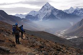
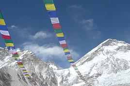
I’m heading to Nepal to do a trek from Kathmandu all the way to Everest Base Camp (a cool 5,300 m 😄).
This trek is a bit special because even though I’ll be part of a group, I’m going solo (so far, no problem—I’m used to it). But it’s my first real trek, and it’s also a humanitarian one: once I reach base camp, I’ll stay an extra week to help clean up the waste left by tens of thousands of climbers! Since I’m originally from South America, from two countries that share the Andes, I have a deep respect for mountains—they fascinate me. So Everest… it’s kind of the trip of a lifetime!
So, a little question for those who’ve done treks to Everest before… any tips for good mental preparation (I’m already working on the physical side)?
Hi there, I’m planning the Annapurna Circuit for March 2027 and I’m looking for a local agency with a local guide—preferably French-speaking—to arrange this trek for us. Any suggestions? Thanks
Hello!
We’re spending a few days in Toraja country at the end of May. We’d love to do a day trek—taking our time—on a route that’s stunning in terms of scenery, but not a level 5 in difficulty!
Any suggestions you can share, please?
Thanks in advance
I’d like to do the Mare a Mare Sud in May over 4 days. I’ve found quite a few places to stay along the route, but I’m stuck on the start and finish.
I’ll be arriving by plane on Sunday evening and would like to start pretty early on Monday morning. Ideally, accommodation right at the trailhead (Alzu di Gallina) would be amazing, but I can’t find anything. Any tips?
Also, for the transfer from Figari Airport to Porto Vecchio or Alzu di Gallina?
At the end, I’d like to pick up a rental car—any advice on that too?
I’m traveling solo by plane to Catania in May and plan to hike the northern side of Etna, starting from Linguaglossa where I’ll arrive by bus. After that, I’d love some info on how to get up to Piano Provenzana (shuttles or hitchhiking), since it seems there’s no public transport except in the summer. Can you sleep there in a free or cheap refuge, or camp? And how far up can you go without having to hire a guide? Thanks in advance. Bernard.
Bonjour a tous,
je pars en voyage au Maroc en aout et nous allons commencer par nous arrêter a Chefchaouen(nous sommes en voiture).
Ma question: quelqu'un peut il m'indiquer un itinéraire de rando en boucle d'entre 5 et 7 jours aux départ de Chefchaouen dans le parc de Talassemtane passant si possible par le pont de dieux?Ou un guide papier qui en reunis quelques uns?
Nous privilégions le camping sauvage et les gites.
Merci d'avance
Hi there, for those who’ve been recently—is it possible to find other solo travelers in March on the island to share transport or room costs? It doesn’t seem easy to travel on a budget.
If you have any recommendations for simple lodgings or places with dorms, I’d love to hear them.
For those who’ve done multi-day treks while moving around: do you need to bring your own sleeping bag? I’d love to hear about itineraries you’ve done without a guide, just with a map and GPS.
Thanks, and have a great day!
Hi everyone!
We’re planning a 15-day road trip to Scotland this summer, specifically to explore and hike on Lewis and Harris—places we’ve never been before. We’ve visited other islands on previous road trips in Scotland (we usually go in April for a week). This would be our first time in Scotland in the summer and for 15 days. We’re looking at late August to early September.
I’m currently drafting the itinerary. We’d be crossing from Ullapool and were thinking of spending 3 nights on Harris and 4 nights on Lewis.
Does that sound balanced to you? Is it better to keep the same accommodation on Harris and the same on Lewis to explore the area? I’d love to hear about any past experiences you’ve had on these islands.
Thanks!
Hi there, I’m trying to leave for 15 days very soon to São Vicente. I’m either looking to join an agency or figure things out on my own to go hiking on one of these islands or both. From what I’ve seen, it’s not easy to organize with local transport, so it gets expensive. Can I use the services of a small local agency? I’m looking for the simplest way to hike for several days. Also, how do you get from São Vicente to São Nicolau? Thanks in advance and have a great day!
Aichatou
I’ve been wanting to do this for several years, and this year’s the one. Next September, I’ll be trekking in Tusheti (Georgia), from Omalo to Shatili.
Of course, I won’t be renting a vehicle that’d just sit unused. No problem getting to Pshaveli, but from there to Omalo, it’s a dirt road (still the case?)
There must be some form of public transport since there are so many guesthouses, and not all travelers come in a 4x4.
If any of you have been to Omalo, could you confirm that these shared transports exist and how often they run?
we’re planning a trip to Yellowstone and hoping to do a three-day backcountry hike if we get a permit.
if any of you have done this before, could you let me know if it’s possible to find water along the way? And if we can transport it, are we allowed to use a stove?
Hello,
I’ll be in Nepal from March 6th to 29th (we’re flying into Kathmandu via Varanasi and leaving via Delhi).
I’m a bit confused about the regulations requiring a guide.
My wife and I (we’re 63 and 64) aren’t experienced trekkers—we’re more used to walking on terrain with very moderate elevation changes. I’m looking for fairly easy hikes, possibly day trips.
Here are my questions:
- Does the Poon Hill trek from Pokhara require a guide, or is it better to go through a local agency? (I’ve seen a lot of them offering 4-day packages)
- I’d like to do a few multi-day hikes around Jomsom (Kagbeni, Mukitinath, Lupra, Marpha)... Do you need a guide for those, and can you find accommodations easily without booking in advance?
Last question—I’m really hesitant to lug around a sleeping bag or down jacket during our 6 weeks in India. Can you easily find these kinds of items at reasonable prices in Pokhara?
Thanks in advance for any tips you can share!
Yann