1°/ le Rif, pas facile ....
Nous avons essayé l'année dernière de traverser le Rif en 4x4, en son milieu. Cela fait de nombreuses années que je voyage au Maroc (une bonne cinquantaine de voyages) et j'avais toujours zapé le Rif.
Bref, j'ai tracé un parcours piste de TAOUNATE à CHEFCHAOUEN. Dès le premier bivouac, nous avons reçu la visite des gendarmes, nous avons eu au téléphone le Préfet. On nous a demandé de quitter les lieux rapidement, car nous étions soi-disant en danger. En pleine nuit, nous avons démonté notre campement, et les gendarmes nous ont remis sur la route de CHEFCHAOUEN. Les autorités nous ont dit que les touristes n'étaient pas les bienvenus dans ce secteur.
Moralité, je n'y foutrai plus les pieds, il y a tant d'autres endroits bien plus sympa au Maroc.
2°/ Pour rejoindre le Sud.
Connais tu les guides GANDINI ?
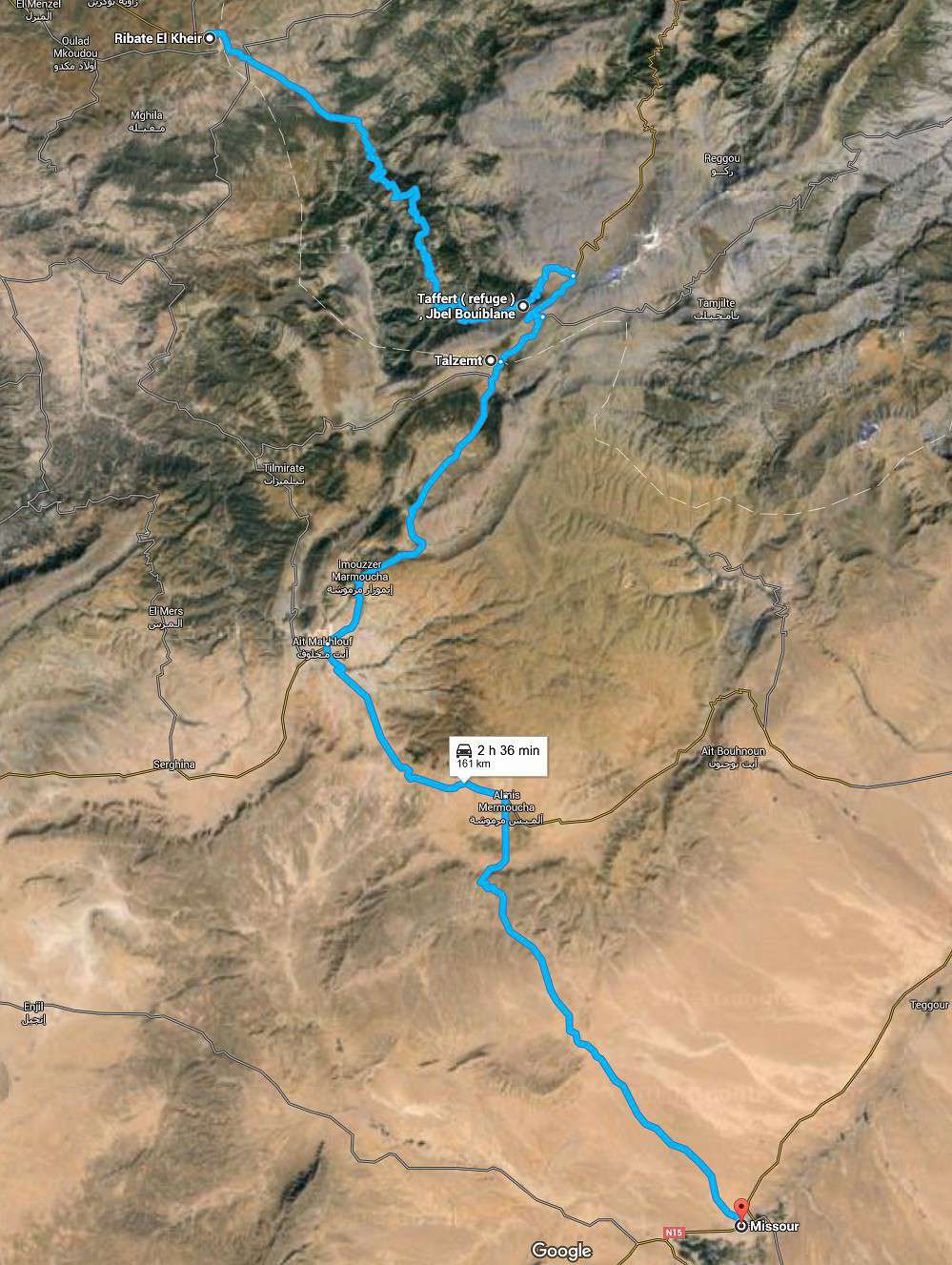
Sinon nous avons fait : RIBATE EL KHEIR puis la route R504 en direction du Refuge TAFFERT (moitié goudron et moitié piste). très joli parcours. Après le refuge TAFFERT tu trouveras un embranchement et tu prends la P5115 en direction de TALZEMT - IMMOUZZER et MISSOUR.
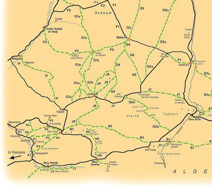
A Missour tu as des pistes qui partent sur le plateau du Rekkam pour rejoindre BOUDNIB.
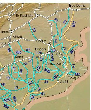
A BOUDNIB il te faut prendre l'itinéraire GT1 qui te conduit à ERFOUD, une partie en hors piste bien sympa.
Salut Jean Marc
Merci de toujours faire référence à mes guides.
Voici une info sur mon prochain programme au Maroc pour ceux qui pourraient être intéressés.
En septembre et octobre prochain, je retourne au Maroc. Au programme passage au début dans le Zerhoun présenter le nouveau guide aux autorités locales. Après être passé voir les copains de Marrakech, détour aux Aït Bougmez pour aller contrôler où en est exactement la fin des travaux de la nouvelle piste Toufna du Tizi n'Aït Imi, parcours GT5a de la nouvelle édition du Tome 1 de Pistes du Maroc. En même temps je vais en profiter pour aller faire les relevés de quelques sites à traces de dinosaures que l'on m'a signalés et qui ne sont pas encore sur mon site www.prehistoire-du-maroc.com.
Ensuite petit séjour chez moi à Ouarzazate.
La suite du programme va se dérouler vers le sud encore un peu chaud à cette époque (en gros à partir du 15/20 septembre). En priorité, il est indispensable d'aller examiner où en est exactement la situation de circulation sur le GT Bou Denib – Embouchure du Draa (Tome 2). Hoceine Ahalfi, mon assistant, et plusieurs d'entre vous m'ont informé de certaines difficultés rencontrées au printemps dernier sur ce parcours, surtout de la part des postes militaires qui refusent le passage aux touristes et des intempéries des hivers derniers qui ont beaucoup raviné certains tronçons.
Un prochain guide est au programme, un peu différent de l'habituel. Ce sera « Sur les traces de Charles Foucauld ». Je profiterai de mon séjour dans le sud pour essayer de repérer dans la vallée du Draa la partie la plus intéressante pour les DPM. Le départ s'effectuera au départ de Tikkirt, le douar au plus près de Ouarzazate par où il est passé en venant de la vallée d'Ounila.
Il est évident qu'au départ de Tanger, jusqu'à sa sortie du Maroc par Oujda, ce ne sera pas un intégral de pistes, mais on essayera de faire au plus près avec la copie de l'intégral des 20 cartes de l'atlas qui accompagnait la première édition (1888) de son ouvrage resté célèbre : Reconnaissance au Maroc 1883-1884, que j'ai pu me procurer.
Je me permet de rappeler qu'avec Hoceine nous acceptons les DPM qui veulent bien participer à nos reconnaissances. C'est bien sûr gratuit et il est important de savoir que la majorité de nos nuits se passent en bivouac.
On peut me contacter directement par courriel : dpm30@sfr.fr
Merci pour ton attention.
Bien à toi
merci à toi, qui m'a permis de découvrir beaucoup de site au Maroc qui m'étaient inconnus. Je devrais être au Maroc sur la même période que toi, je ne manquerai pas de te le préciser d'ici là.
Effectivement les parcours le long de la frontière algérienne deviennent difficiles. Années après années, le nombre de postes militaires augmentent et on nous renvoie régulièrement vers le goudron, surtout entre FOUM ZGUID et TATA.
Concernant charles foucauld je suis preneur, cela fait de nombreuses années que je circule sur les traces de cet homme ...
je suis passé chez toi à OUARZAZATE en octobre 2015 et 2014, mais tu n'y étais pas, la prochaine fois inchallah...
Etat de la piste Ketama / Talzmet / Missour / Erfoud en 4 x4 leger ou moto enduro en septembre octobre ?
Quelle traces utiliser pour rejoindre Chechaouen / Erfoud ?
Habituellement je descend par Fes / Midlet
Merci d'avance pour vos réponses
bonsoir !
nous avons fait ce trajet en octobre 2015, en sachant qu' à partir de Ketama , nous avons pris la direction de Targuist, le barrage Asfalou
et direction Tazaa puis Tamtroucht
et talzemt ensuite immouzzer Marmoucha et almis marmoucha jusqu' à Missour ( tout par la route ) ensuite pour la piste pour Erfoud c' est par Boudenib . ( comme explique un peu plus haut Jean Marc)
(je peux t' envoyer une trace , fichier gpx par MP )
voilà vite résumé ! 😉
Je pense qu'il y a maintes façons de traverser le RIF. Lors de mes premiers voyages, je ne flambais pas entre Tétouan et Kétama. Contrairement aux recommandations du Michelin de l'époque (1990), je suis parti de Fès sans le plein et donc obligation de le faire à Kétama. De là, les R 12 nous suivaient, dépassaient, freinaient sur la route étroite pour forcer à s'arrêter. Nous étions deux véhicule, Toyota et Range-Rover et on les obligeait à dégager mais c'était très tendu jusqu'au carrefour de Chaouen où là, c'était la police qui nous attendait. Depuis, les temps ont changé, j'ai même participé, pour la photo, au labour avec une paire de mules. Depuis, j'ai traversé ce Rif soit par des "Gandini" ou des pistes trouvées grâce à Google-earth.
J'ai bivouaqué plusieurs fois sans problème mais dans le froid ou la brume. Ma dernière traversée qui est plus Est en avril était en suivant la côte jusqu'à Nador puis la N19, le tour du barrage Hommadi puis la retenue du barrage Mohammed V, à nouveau la N19 jusqu'à Taourirt, Guercif, Mahirija puis des Gandini jusqu'à Talsinnt et Beni Tajjite. Certaines pistes ont disparu, je n'ai pas pu rejoindre Rchida. La navigation demeure cependant intéressante par des pistes peu ou plus fréquentées.
Pistes près de la frontière :
-en 2015, je suis arrivé, depuis la gare de Mengoub, au poste face au mémorial Leclerc. Interdit de repartir. En attendant le chef, j'ai réussi à sortir mon déjeuner, faire des photos mais quand le chef est arrivé, j'ai été prié, après appel au commandant de la région de Bouarfa, de partir et de ne plus revenir.
-en avril, j'ai négocié et obtenu le passage, venant de M'Hamid, jusqu'à Tata.
Pour Monsieur Gandini : J'ai fait la Michel Vieuchange en 2008, pas facile, j'ai voulu récidiver mais bien des choses ont changé entre Tiglit et M'Seied, notamment le gué sur le Draa mais il est possible de le franchir depuis Aouint Ighoumane pour rejoindre le plateau de Boumgueil. De là, rejoindre M'Seied par le goudron, je n'ai pas osé le passage par Tafraout déjà très difficile en 2008. Le goudron joint Tafraout à la route M'Seied-Tantan
Jusqu'à Smara, que du plaisir, de l'espace et la grande solitude, le vrai désert.............
Bon Maroc à ceux qui "fouillent", il reste à explorer................
bonjour
c' était pour moi la première fois une traversée du Riff en octobre 2015 et je pense que les choses ont bien changées , il y a quelques années cela était plus difficile comme tu le dis Bernard et ce que m' a raconté mon pilote attitré qui plus ancien que moi 😉 sur les pistes d' Afrique .
bien que la police ne vous laisse pas toujours bivouaquer ou bon vous semble et vous redirige gentiment vers un camping.
nous avons fait la traversée Amsa -Bab taza (vraiment superbe , avec la traversée du parc national Talassemtane ) parcours fait par piste sèche car dans le cas contraire cela peut être très délicat.
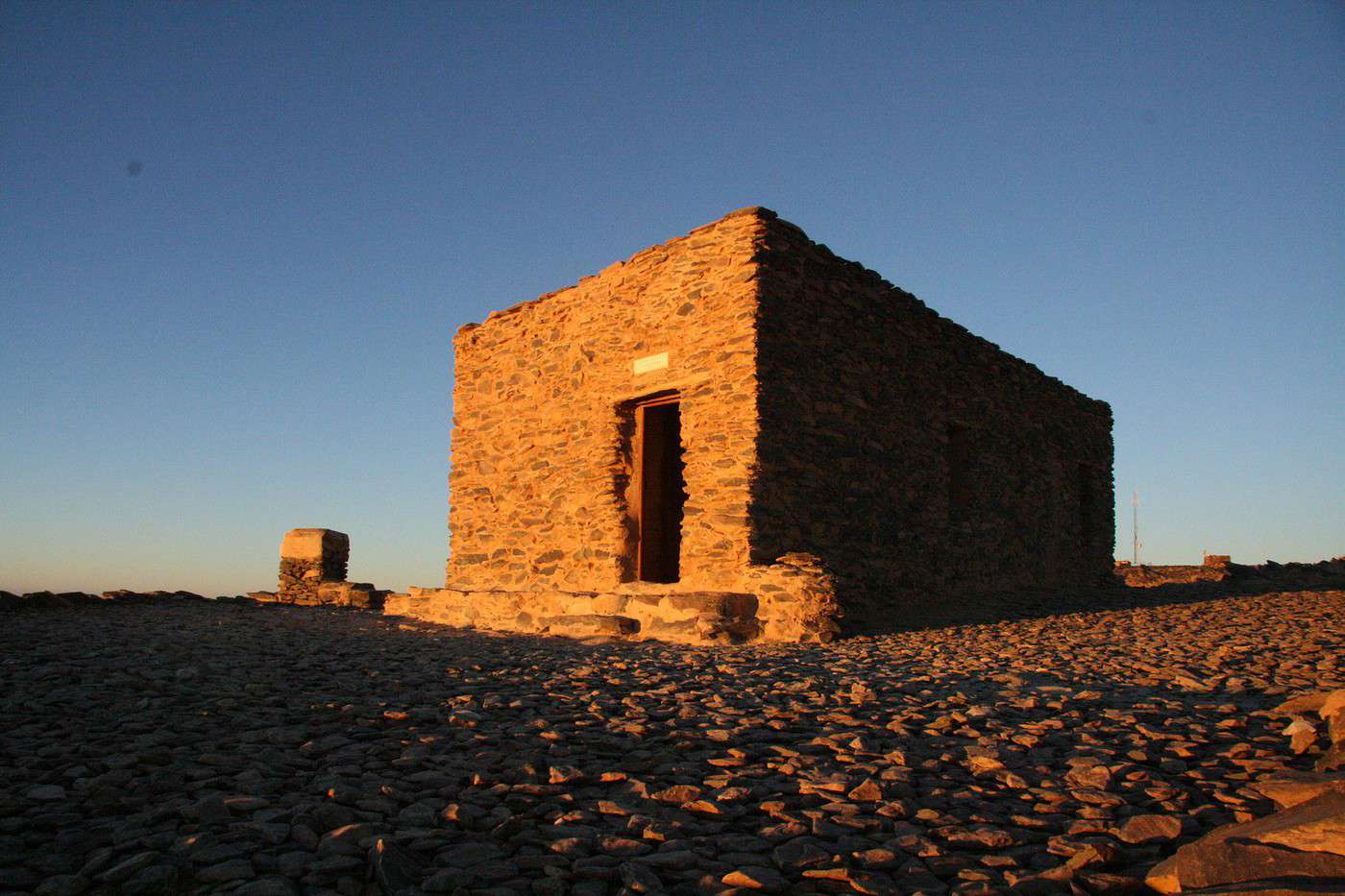
(djebel Tazaouzet)
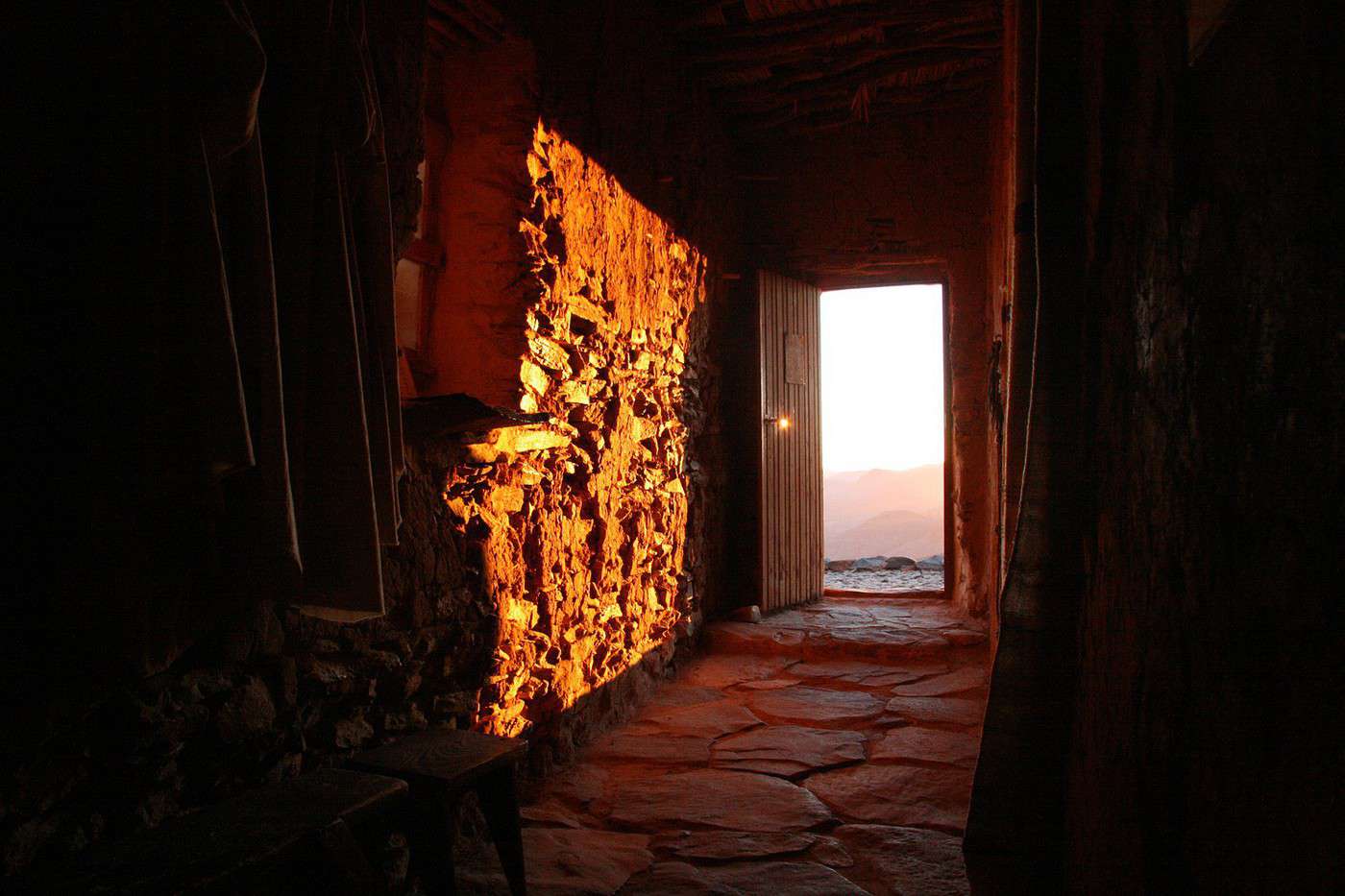
(sur les hauteurs de Tazaa )
Rchida on a pu accéder au plateau du Rekkam par la piste Gandini vers la maison forestière en 2011. (ancien passage du Dakar 2007)
et comme tu le dis il reste plein de pistes à découvrir au Maroc .🙂
serge
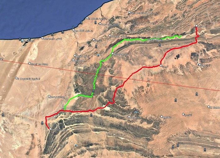
After 40 years of traveling in Morocco, I want to explore a new area by 4x4—the Western Moroccan Sahara, which I don’t know very well.
I have plenty of tracks and itineraries, but I’d love some info to help me decide on the best route:
Part 1:
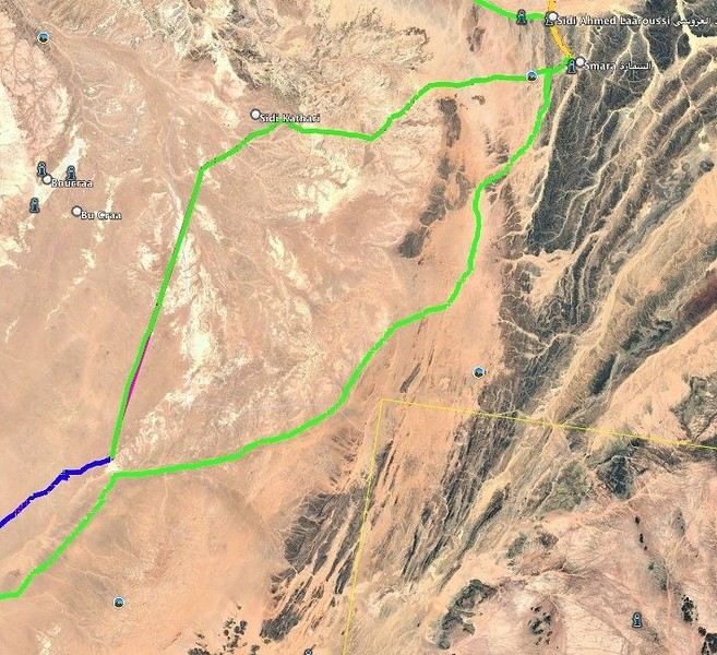
I want to do the ASSA - SMARA crossing. Basically, I have two options: the first follows the Draa River and goes through M’SIED, and the second is much further south, passing through LABOUIRAT and heading straight to SMARA.
If you have any details on road conditions, driving restrictions, etc., I’d really appreciate it.
Part 2:
SMARA - BIR ANZERANE - DAKHLA – here, I also have two routes.
The first heads west from Smara toward Sidi Kathari.
The second goes east from SMARA and gets pretty close to the border at one point (about 10 km away).
Both routes meet up about 150 km later and are nearly identical from there to BIR ANZERANE and DAKHLA.
Hi,
For next summer’s vacation, I’m thinking of returning to the Sahara after visiting Tamanrasset and the Hoggar, which was stunning—not to mention the Tuareg hospitality.
I’d like to explore the sandy desert this time since the Hoggar was 80% rocky.
So, I’m wondering which city I should prioritize if I want to go there in late July–early August for the landscapes, extreme heat, and guides offering 4x4 and camel treks. Also, if there are any recommended guides for those in the know and a decent hotel.
I’m torn between Djanet, In Salah, Adrar, Ghardaïa, and Timimoun.
I’m of Algerian origin, so no visa or other formalities to worry about.
Thanks.
Hello, I’m preparing for a Tunisia-Algeria road trip.
I need to know if we can cross the Sahara to reach Djanet and Tamanrasset by road freely,
After that, obviously off-road in the desert with a guide.
What do the authorities say?
My trip: northern and southern Tunisia, a stroll in the desert.
Crossing the Tunisia-Algeria border via the Taleb Larbi customs.
I’ve already done this route through an agency, but this time we want to do it on our own.
Then heading down to Djanet for eight to fifteen days in the desert with Mouloud, a local guide.
Direction Tamanrasset: road and tracks, the mountains of the Assekrem, the Hermitage of Père de Foucauld.
Return via the Trans-Saharan Highway.
Visit to northern Algeria, then back by boat from Oran to Spain.
Dates: late December to mid-February.
We’ve got plenty of time.
If another crew is interested, we’re already two vehicles.
Looking forward to your replies.
Hi there,
I’m planning a trip to Russia and Mongolia, starting from France.
Crossing the border at Poland/Belarus or Georgia/Russia—other borders seem either closed or complicated.
Tourist visas for 3 months with multiple entries.
Do you have any info on Russian companies that cover a 4x4 vehicle for 3 months, and what prices in rubles or euros you’ve paid?
Which bank did you use for expenses? (EuroMastercard and Visa cards no longer work.)
Regarding Russian SIM cards, a new system called "Gosuslugi" has been introduced. How long did it take you to get one, and what steps did you follow?
Hi there,
We’ll be traveling in January 2027 in a 4x4 with a rooftop tent with our three kids, from Johannesburg to Cape Town. We’ve already booked several campsites in national parks (Golden Gate / Mountain Zebra / Addo Elephant / Garden Route).
We still need to reserve the stretch between De Hoop Nature Reserve and Cape Town. Any suggestions?
We’d love to stay around Cape Town for 5 days to explore the wine route, the peninsula, and do some hikes in Table Mountain.
Any camping recommendations? Or, on the contrary, places to avoid?
Also, we have 2 nights left near Wilderness National Park / Knysna. Any recommendations?
Thanks so much for your help!
For my 60th birthday (yes, I’m jumping the gun a bit!), I’m starting to plan a self-drive trip to Tanzania (in June).
I also considered Zimbabwe but I’m worried it might be a bit chilly at night in June.
I’ve revisited an itinerary I’d thought about before, tweaking it since I’ll have more days to dedicate to this trip. Still no big northern classics for the same reasons as before (too expensive, too crowded, too many tour operators).
Here’s what I’ve got so far:
(Arrival/departure from Kilimanjaro Airport)
Night 1: Arusha
Night 2: Arusha
Night 3: Lake Manyara
Night 4: On the way to Iringa (any ideas???)
Night 5: Iringa
Nights 6–8: Ruaha NP
Nights 9–10: Mikumi NP
Night 11: Bagamoyo
Nights 12–15: Beach
Nights 16–17: Lushoto
Nights 18–19: Mkomazi NP
Night 20: Toward Marangu – eastern Kilimanjaro
Night 21: Western Kilimanjaro
End of trip
All your ideas, tweaks, info, and suggestions on this route are welcome!
I could move one beach night somewhere else if needed.
Also, if you have a car rental company to recommend or thoughts on the bandas rented in the parks, I’m all ears!
Finally, what are the roads like in Ruaha in June? The rental company I’m looking at seems to allow this park with a small 4x4. (Off-limits: Serengeti and Natron)
We’re planning a long-term trip starting in April with our 4x4, beginning in the USA.
We’re still looking for car insurance that covers Canada and the USA.
We’ve read quite a few forums, but we’re hoping for some help (from fellow travelers).
Hi,
we’re planning to visit a park again.
Could you point us toward the camps in Gonarezhou Park?
>We’re traveling completely self-sufficiently.
We love wildlife.
Thanks for any tips you can share!
JP
Hi there, we’ll be in Mozambique in early December 2026 and we’d like to travel from Vilanculos to Beira by car or bus to reach Beira airport. After that, we’re planning to visit Gorongosa National Park before flying back to France from Beira. From what we’ve heard, the road to Beira is tricky, especially at this time of year (start of the rainy season). Could anyone share their thoughts or suggest a solution? Thanks so much for your help!
Anne
Hi there,
I’m heading to Lesotho in a few days and I’m struggling to find info on the best route between Katse Dam and Sehlathebe National Park. There’s a fairly "direct" route from Thaba Tseka, but the roads seem rough, and we’re not exactly 4x4 pros. Anyone have any tips to share? Thanks!
Hi everyone,
We’re heading to Mozambique in October and are looking for either a 4x4 or 4x2 rental in Maputo, or a driver transfer option to reach:
- Ponta Do Ouro
- Tofo
- Vilankulos
The idea is to be self-sufficient for sightseeing and stops while still being able to access certain lodges or beaches that require a 4x2.
Do you have any contacts, addresses, or ideas to share?
Thanks in advance,
Hello,
We're hitting the road again in 2027 to discover new countries and cultures.
Could anyone give me some tips on driving from Ulaanbaatar to Lake Baikal and the route to take?
Thanks, and safe travels to those who are setting off!
We’re planning a 4x4 trip from Belgium to Central Asia, passing through Georgia, Russia, Uzbekistan, Kazakhstan, and Kyrgyzstan.
For these countries, our national insurance obviously doesn’t cover the vehicle, so we’ll need to get local insurance.
Will it be a problem if the vehicle is registered under person A and the national insurance is under person B? Both A and B will be in the vehicle, and both will be listed as drivers on the insurance.
When we get the local insurance, if we again list A and B as drivers, does the order matter? Could we get stuck at the border for this reason?
Hi,
For those who’ve driven on Iceland’s gravel roads in their own or a rented Duster, could you tell me what tires were fitted on the vehicle?
Were they All Terrain tires or more "standard" ones like all-season tires, for example?
Follow-up question: if they were "standard" tires, did that cause any issues on the gravel roads and rough terrain?
Thanks so much for any info you can share.
Best,
Marc
Hi there,
I'm planning a 4x4 road trip from Darwin to Broome with a rooftop tent in July 2026.
I'd like to know if I need to book overnight stops in advance or if I can just wing it and stop wherever I feel like it?
Some evenings, we'd like to stop and make use of campsite facilities (restaurant, shop, showers, toilets).
What do you recommend?
Do I need a permit?
My rough itinerary looks like this:
Darwin - Kakadu
Kakadu - Nitmiluk
Nitmiluk - Kununurra
Kununurra - Purnululu
Purnululu - El Questro
El Questro - Mt Elizabeth - Bell Gorge - Broome
I’m planning a trip to Iceland for next July-August, with a car and tent, and I’m wondering about booking campsites.
From your experience, is it necessary or even essential to book campsites in advance, or do you always manage to find a spot to pitch your tent?
We’ll also have the option to sleep in the car without pitching the tent.
Does that give us the flexibility to stay outside a campsite for a night here and there?
Hi,
I’m planning a road trip in the Middle Atlas, starting and ending in Fez and heading down to the south of Midelt, the Assoul Massif.... We’ll be traveling with two small 4x4s.
I’m looking for detailed maps of this region that include small roads and tracks.
Last year, we had a fantastic road trip in the Anti-Atlas and High Atlas using Erfahren maps, but unfortunately, they don’t cover the area we’re interested in this year.
Thanks for your suggestions!
Dominique
We’re planning a 13-day family road trip in Morocco this July, with six people in a Toyota Prado 4x4 (renting in Marrakech).
We’ll alternate between bivouacking and small hotels/riads depending on the stops.
Here’s the planned route (in this order):
Marrakech
→ Ouarzazate
→ Draa Valley
→ Zagora
→ Erg Chegaga
→ Lake Iriki
→ Foum Zguid
→ Tata
→ Tafraoute
→ Aït Mansour
→ Tiznit
→ Mirleft
→ Taroudant
→ Back to Marrakech
Our goal:
Atlas Mountains + desert + dunes + plateaus + valleys + a bit of coastline.
We’ll cover about 1,700 km in total.
We’re planning:
Bivouacking in the Chegaga/Iriki area
Flexible for the rest (booking the day before or same day)
Sand gear: traction plates, compressor, tow strap, roof rack
Questions:
Is the Zagora → Chegaga → Iriki → Foum Zguid crossing in July doable on our own (single vehicle, no guide)?
Are there any truly technical or risky sections between Chegaga and Iriki?
Does the overall itinerary seem manageable in 13 days without rushing?
Any suggestions for great bivouac spots or particularly interesting stops along this route?
The points on the route are provisional overnight stops. Some spots will include two nights in the same area.
We’re used to off-road driving, but not yet in the Moroccan desert.
Thanks in advance for your feedback and tips! 😊
Good evening
I could use some advice 🙂
Our trip to Namibia is planned for June/July 2026.
We’re struggling a bit with timing and choosing activities for the part of the trip between Sesriem and Brandberg.
Day 1: Sesriem to Mirabib
Day 2: Mirabib to Swakopmund – visit Swakopmund, overnight in Swakopmund
Day 3: Sandwich Harbour – overnight in Swakopmund
Day 4: Kayaking with the seals + the living dunes – overnight in Swakopmund
Day 5: Moon Landscape, Henties Bay + Cape Cross – overnight at White Lady Lodge in Brandberg
Does this itinerary seem realistic to you? Is Cape Cross really worth the trip? If I had to choose between Cape Cross and kayaking with the seals, which would you recommend?
Thanks in advance for your help!
Hélix
My son and I are heading to Georgia this summer to explore the High Caucasus (Svaneti, Kazbek, and Tusheti regions). For this, we’re planning to rent a 4x4.
However, the rental agencies we’ve found prohibit driving on the tracks to Omalo (Tusheti) and/or Ushguli (Svaneti).
Do you know of any agencies in Tbilisi (local and reliable) that allow rented 4x4s to drive on these tracks? If so, which ones?
Hi everyone,
I’m starting to plan an itinerary for September 2027 focused on Zimbabwe and Zambia. I’d love to visit Gonarezhou National Park—I see there are two sectors: the Mwenezi Region in the south and the area around the Runde River in the north. Should I cover both sectors or just focus on the northern region?
For the parks along the Zambezi River, is it better to visit Mana Pools on the Zimbabwe side or Lower Zambezi on the Zambia side?
Thanks in advance for any tips on the parks in these two countries.
Have a great day, everyone.
We’re spending 18 days in New Zealand from 05/04 to 05/21, arriving in QUEENSTOWN and leaving from AUCKLAND.
Any ideas for a road trip that covers the highlights of both islands but only changes hotels every 3–4 nights?
Thanks.
For our trip to Georgia in July, I’d like to rent a 4x4 starting from Tbilisi.
Do you have any rental companies to recommend?
The traditional rentals like Hertz, Avis, etc. seem way overpriced compared to local companies—what do you think? Are they properly insured?
Has anyone here tried Geo Rent Car, Auto 4 Rental, or Sur Price?
Also, I’m looking for info on the condition of the Ushguli–Lentekhi track—is it passable?
Hi everyone,
A well-prepped 4x4, a travel plan across Africa in stages since I’ve got kids to see regularly and work to earn a living.
I’m leaving in November for about a month with the goal of reaching Senegal via Mauritania. I’d love to share this trip with someone who wants to discover Mauritania and a bit of Senegal... and also experience life on board a 4x4 in the desert or bush, sometimes sleeping in the vehicle or in hostels/small hotels for comfort. I want to share this rediscovery because two’s better than one!
Just traveling, exploring, and living! !
I’m planning to explore Argentine and Chilean Patagonia for a month in December 2019.
I’m looking for a rental company (or several) that offers single-cab 4x4 pick-ups with a fitted camper cell for two people. I’m specifically after a vehicle with an indoor shower for extra comfort ;)
So, no vans—at least not from the rental companies I’ve seen so far.
While browsing the forum, I came across the Chilean rental company Holiday Rent. But do you have any recommendations for Argentine rentals?
Because, if I can’t return the vehicle in the same city as pickup, I’d prefer—and it’d likely be cheaper—to at least return it in the same country.
I’m traveling through Argentina and Chile (as well as Paraguay and Uruguay) with a 2019 Toyota Hilux Euro 6. Could anyone tell me if the local diesel is suitable for its engine, or if I need to take any special precautions (like adding an additive, for example) for these countries?
I’d also like to know if driving at high altitudes is possible, and up to what elevation—or if I should worry about the vehicle going into limp mode?
If that happens, what should I do?
Hi there,
Can you tell me if the road between Zagora and M'Gouna is easy or difficult for a 4x4? How much time and how many kilometers should I plan for? I’m traveling in May.
Thanks!
 et direction Tazaa puis Tamtroucht
 et talzemt ensuite immouzzer Marmoucha et almis marmoucha jusqu' à Missour ( tout par la route ) ensuite pour la piste pour Erfoud c' est par Boudenib . ( comme explique un peu plus haut Jean Marc)
 (je peux t' envoyer une trace , fichier gpx par MP )
voilà vite résumé ! 😉
(je peux t' envoyer une trace , fichier gpx par MP )
voilà vite résumé ! 😉

 (sur les hauteurs de Tazaa )