Si c'est pour t'orienter comme en France , " tournez à droite au prochain carrefour" (d'une belle voie féminine) NON ça ne fonctionne pas en Afrique !!
Il te faut des points GPS que tu entre dans ton GPS et qui te guide via une fléche ...
Des parcours au GPS ça existe pour le Maroc et Mauritanie (voir guide papier)
Pour le reste il faut "naviguer" avec les cartes routière IGN , où les pistes principales y sont bien dessinées
Par contre sur certain blog de voyage (exemple le notre) il y a des points GPS qui peuvent te guider dans une ville pour trouver un bâtiment administratif (par exemple) pour faire ton visa (auberge/hôtel ...)
Tu peu aussi enregistrer ta trace sur un GPS (la trace de ton parcours) au cas où tu te perde !! tu peu revenir exactement sur tes traces .. ETC ...
Voila
Juste pour information, il existe des cartes sur tracks4africa.co.za qui te permettent de faire des trajets en Afrique avec la dame qui te dit "tourne à droite, tourne à gauche", y compris sur les pistes un peu perdues. Ces cartes ne fonctionnent que sur des GPS Garmin (jusqu à aujourd'hui).
Par contre ces cartes existent pour l Afrique Australe et le Maroc. Je ne sais si elles existent pour l'afrique de l ouest ?
A+
Franck
(un fan du blog de Papy dont les voyages font rêver...😛)
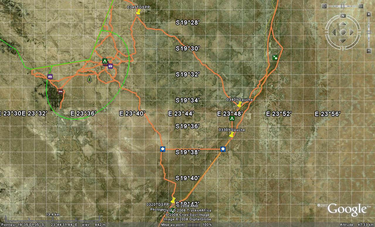
Ci dessous un exemple : Grandes Pistes en blanc, petites pistes en marron (au Botswana)
Tanzanie-2010
Kawaza Village
Botswana : https://voyageforum.com/v.f?post=2037270
bien la reponse merci de votre aide au fait c'est un chameau qui vous a abime ?, , sinon ça va vous avez fait verifier les niveaux n'oubliez pas Inteligence ça se vend en paquet de quatre comme la biere alterne ça irra mieux apres
Yo mon gars,
roulepartout est plutot taquin, pas la peine de t'énerver. Il n'y a pas de carte pour Afrique de l'ouest en adéquation avec un gps. donc le plan garmin cool surtout si tu fais un saut par l'australie.
Sinon tu fais comme dis papy c'est tout !!
et pour ne pas tomber dans un plan palmier à gauche demander et parfois sympa et aussi pas mal fiable en plus ça lie la conversation et hop un thé et c'est reparti !!
Enregistre bien tes points gps arrivé au point B et là ça te servira et ça servira aussi aux potos du forum.
Faire tourner les coordonnées c'est ce qui te créera TA carte à tôa.. et elle est compatible voyage forum.
Bonne route,
ok ça j'ai compris je cherche quel marque de gps il vaut mieux acheter je sais qu'il n'y a pas de carte pour f'afrique juste le modele qui vous semble le mieux
🤪 désolé mvtc si mon post t'as paru blessant...ce n'était pas mon intention, je ne te connais pas, pas question donc de te juger, j'ai moi même écris de sacré conneries ici😄...je voulais juste plaisanter non pas sur ton message mais sur l'existance d'un éventuelle gps du desert...de toute facon je l'avoue je ne sais pas me servir de ces betes la, je n'en ai jamais utilisé ( bon je sais techniquement comment cela fonctionne mais j'en ai jamais eu dans ma voiture)...
après c'est juste une question, pourquoi un gps? pouvoir trouver ta route? ou savoir te situer?
C'est vrai qu un GPS c'est bien pratique pour savoir où on est perdu... 😊 😉
Si je peux me permettre de m'immiscer...
T indiquer une marque de GPS c'est délicat, et après faut choisir un modèle et ça se complique encore. Regarde chez Garmin il y a je ne sais combien de bestioles... !
Le plus important (sans carte téléchargeable) dans le désert ou ailleurs c'est de pouvoir aller d un point A à un point B, mais les GPS actuels ne sont pas hyper doués pour gérer des points "qui n'existent pas".
Par exemple le mien ne veut jamais me tracer une route si mon point de départ ou d'arrivée est au milieu de rien.
Bon, dans le temps il y avait le garmin 276 ou 278 qui sont très polyvalents, je veux dire donc "désert" aussi, mais aujourd'hui avec mon ZUMO 550 je ne peux même pas consulter les coordonnées GPS d un POI pour les donner à mon pote...
Regarde sur Orbitica.com ou sur Garmin.com il y a beaucoup de fiches techniques et possibilités de comparer des matos...
Mais te conseiller...!
Si je devais chercher un GPS je pense que je chercherais un 276 ou 278 d'occasion... car VRAIMENT polyvalents ou un 60 CSX, mais il doit y avoir d'autres modèles...?
Bonne chasse au trésor...
Tiens nous au courant, les résultats de tes recherches nous intéressent.. !
😛
F
Tanzanie-2010
Kawaza Village
Botswana : https://voyageforum.com/v.f?post=2037270
bonjour,
d'accord avec les GPS Garmin, qui valent chers mais bien plus performants que le TomTom et autres gadgets pour citadins. les modèles bateaux de petite taille (et donc adaptables dans une voiture) sont plus intéressants en partant dans des contrées non tracées, car certains sont équipés de cartes Monde, avec le relief principal et parfois les grands axes. de plus il est possible de convertir des cartes numérisées pour être exploitées par le GPS. je n'ai plus ni les modèles ni le nom du logiciel mais c'est assez facile à trouver sur les sites comparateurs, dont certains conservent les traces des anciens modèles plus commercialisés.
pas de cartes GPS officielles de l'Afrique de L'ouest, probablement en l'absence de réel marché.
ce site est pas mal et indépendant : http://www.la-rose-des-vents.fr/gps-choix.php#
niveau budget, compter entre 700 et 1500 euro pour un appareil neuf.
BONJOUR, j'utilise depuis plusieures années un GPS 276 garmin avec une cartographie world map de garmin. Tout fonctionne parfaitement, la carte est assez precise et les grands axes et pistes principales sont bien marquées. Apres pour recuperer des points supplementaires tu les trouvent sur les differents forums, si tu demande gentiment tu les reçois dans ta boites mail .... a partir de ces points avec map source ( le programme de garmin ) tu fabrique ta route que tu injecte dans le GPS. Un seul probleme le 276 a ete supprimé de la gamme garmin et son remplaçant le 620 n'enregistre pas la trace en routier seulement les points ....... c'est un peu con si tu veux rebrousser chemin.
quand je sort de la voiture et aussi par precaution j'ai un 60CSX ( je l'utilise aussi en randonnee en montagne ) il est parfait avec les meme fonction que le 276 seul l'ecran est petit.
a mon avis un 60csx et world map et un petit note book ou un vieux portable t'es le roi du petrole ....
si tu veux d'autre renseignements je suis a ta disposition
amities
Dans le désert vivre c'est avancer sans cesse !!! (Theodore Monot )
Bonjour,
Je te confirme qu'un GPS en Afrique est très intéressant. J'ai le garmin 278 (hélas arrêté) avec les cartes de toute l'Afrique. Bien entendu elles sont grossières mais avec tous les cours d'eau, les grands villages, les routes principales. Le GPS te donne le chemin à suivre, le kilomètrage restant à effectuer, le temps de route estimé sur la base de ta vitesse moyenne, etc... Ce qui permet de naviguer sans se perdre et bien entendu tu peux marquer des Waypoints et y retouner en suivant la flèche comme avec une boussole qui te donne la bonne direction. Très pratique pour retrouver un lieu d'une année sur l'autre ou par exemple une ambassade dans une ville. Le détail des grandes villes pour l'Afrique de l'Ouest est fait là encore grossièrement mais très largement suffisant. Quant aux pistes mal définies c'est indispensable
En navigation à "vol d'oiseau" tu as un trait droit entre le véhicule et le point d'arrivé et une flèche représentant le véhicule avec la pointe qui est vers l'avant ce qui est très pratique car tu vois si tu es sur la bonne direction. Il suffit de mettre le vehicule en superposition avec ce trait tu vois ainsi si tu vas vers le but. Dès que la flèche s'écarte du trait de "vol d'oiseau" alors tu t'écartes de la bonne route. Sans ce GPS en Afrique de l'Ouest je me serais 1000 fois perdu !
Regarde sur mon site à cette page photo en haut et à gauche http://perso.ovh.net/~maslabor/matequip.htm tu le verras en fonctionnement avec une la trace rose qui est la route à suivre (photo prise en Afrique de l'Ouest et pas en France !)
La voix de la femme (c'est gepette !...) ne te donnera pas les routes à prendre car le relevé des voies africaines n'a pas été effectué mais cela ne sert à rien du tout. Pour l'Europe c'est tout de même bien pratique.
j'ai regarde dans mes catlogues les prix:
un 60CSX : 359 euros
world map : 79 euros
un note book avec seven de chez acer : 320 euros
voila tout c'est tout ya plus ca !!!!!
amities
Dans le désert vivre c'est avancer sans cesse !!! (Theodore Monot )
j'ai un peu la même question sur les produits récents et d'après le site la rose des vents, le Aventura Twonav de CompeGps, qui reprend les cartes IGN avec mise à jour gratuite à vie, à l'air le meilleur pour une utilisation en dehors des sentiers battus et il y aurait des cartes de l'Afrique. il coûte 600 euro. autonomie 16h donc tu peux partir à pied avec un seul appareil. ils ne disent pas si la route reste tracée comme sur le Garmin 278.
Bonjour,
je suis tout à fait d'accord avec Routologue. Un garmin qui fait traceur c'est le top. Pour notre 1er voyage en Afrique, nous avons utilisé...Papy ! ( hello Papy merci pour ton super blog) et...un GPS Garmin de randonnées : Etrex venture. L'écran est trop petit mais on a afit avec; nous avons utilisé les points mis en ligne par les copains de VF et le logiciel mapssource qui fait '"tourner" le GPS sur l'ordi. Tu t'armes de patience, tu ouvres mapsources et tu marques tous tes waypoints méticuleusement. Tu crées tes "routes" que tu suis au cap, en mode traceur sur le GPS. çà nous a rassuré mais on a toujours trouvé quelu'un pour nous renseigner. Y'A pas de probléme !
bonne recherche
Anita
Je suis dans le cas également, de chercher un GPS pour l'Afrique. Tout le monde m'a conseillé Garmin, donc OK, je fonce !
Je suis à 95% convaincu par le CSX60 dont Routologue nous a parlé. Juste quelques interrogations :
1) Le petit soft proposé sur tracks4africa.co.za pour avoir quelque chose qui "ressemble" au niveau de la présentation à "la madame qui dit", est-ce que ça a un intérêt sur un GPS mixte rando/marine/voiture comme le CSX60 ? Ou pas besoin ? Ou ça ne fonctionne carrément pas (peut-être que c'est fait justement pour transformer les GPS citadins en GPS de piste ?)
2) J'aime assez bien l'idée d'avoir une représentation du véhicule sur l'écran, histoire de voir si je vais dans la bonne direction. Quelle est l'information visuelle donnée par un GPS mixte comme le CSX60 ? J'ai déjà bien regardé sur le site "rose des vents", mais tout n'est pas clair pour moi. J'aimerais savoir si ce GPS me donnera aussi une information "comme un GPS de route".
3) Il n'y a donc pas de vrai successeur au modèle 276 de Garmin ?
4) Enfin, si je comprends bien, il faut également acheter le programme de Garmin pour faire son itinéraire sur son pc et l'uploader sur le GPS, c'est ça ? Ou bien le programme "Trip & Waypoint Manager" qui est fourni suffit ?
D'avance, merci !
J'espère que vous répondrez vite, car le CSX60 est en promo sur la rose des vents jusqu'au 30 mai ! J'espère qu'ils livrent en Belgique...
EDIT : Au fait, le câble USB qui est dans les accessoires de base, il permet aussi de recharger le GPS via le PC ? Sinon, comment elle se recharge, cette bête ?
Bon je vais essayer mais j ai un peu de mal avec les questions...
On va voir ça...
Le petit soft proposé sur tracks4africa.co.za pour avoir quelque chose qui "ressemble" au niveau de la présentation à "la madame qui dit",
T4A Ce n'est pas un logiciel, c'est une carte avec des Points d Intéret (POI)
est-ce que ça a un intérêt sur un GPS mixte rando/marine/voiture comme le CSX60 ?
Je ne comprends pas la question. Oui ça a un intérêt si tu vas dans un pays d'avoir la carte détaillée.
CSX60 ou 276 ou 278 Garmin, T4A sert à charger des cartes détaillées : routes, pistes, chemins, et POI pompes à essence, campings...
Ou ça ne fonctionne carrément pas (peut-être que c'est fait justement pour transformer les GPS citadins en GPS de piste ?)
Avec ou sans T4A, ton GPS aura les mêmes fonctionnalités. Les GPS de piste sont juste des GPS ... avec des pistes, donc des cartes détaillées.
Quelle est l'information visuelle donnée par un GPS mixte comme le CSX60 ?
Télécharge le mode d'emploi sur mesnotices.fr. Recherche avec google "mode d emploi garmin 60CSX", tu auras une idée des "représentations de véhicules" qui apparaitront à l'écran.
J'aimerais savoir si ce GPS me donnera aussi une information "comme un GPS de route".
Je ne vois pas la différence que tu te fais entre GPS de route en europe et un GPS de route en Afrique. Un GPS c'est un GPS (on ne parle pas ici des GPS marine ou aviation).
Attention : je ne suis pas sur que 60CSX parle. Je pense qu il a offre la possibilité de guidage pas-à-pas, mais je pense que c'est visuel, à l 'écran.
Il n'y a donc pas de vrai successeur au modèle 276 de Garmin ?
Le 660 mais il a moins de fonctionnalités
4) Enfin, si je comprends bien, il faut également acheter le programme de Garmin pour faire son itinéraire sur son pc et l'uploader sur le GPS, c'est ça ? Ou bien le programme "Trip & Waypoint Manager" qui est fourni suffit ?
Je ne connais pas Trip and Waypoints mais à lire la fiche technique il suffit pour transférer les itinéraires et les points GPS. Tu peux aussi télécharger mapsource version 3.13.7 gratuit.
le cable USB permet aussi de recharger le GPS via le PC ?
Je crois que oui.
Sinon, comment elle se recharge, cette bête ?
En le branchant sur l'électricité.
Je crois que je suis décidé pour ce modèle. Mais j'ai encore quelques questions, par rapport à des accessoires que j'hésite à acheter d'emblée (profitons des frais de port) :
1) L'antenne qui se colle sur le pare-brise : est-ce un gros plus ? Si c'est un GPS de randonnée, je suppose que son antenne intégrée (qui dépasse, d'ailleurs) est quand même assez balèze, non ?
2) Piles, recharge, etc. : Si je capte bien, le GPS est livré avec des piles normales, mais on a la possibilité d'acheter des piles rechargeables ? Je me demande si le cordon pour connecter à l'allume-cigare fournit juste le courant ou bien s'il permet également de recharger les piles. Quelle est la meilleure solution ?
3) La carte mémoire fournie par défaut est assez petite : 64Mo. J'imagine que pour charger les cartes que le programme Mapsource Worldmap me fournira, il me faudra plus de place que ça... Un conseil pour la taille ?
Je bourlingue en 4x4 avec famille jusqu'à Abidjan en novembre 2010, je compte me servire de l'iPhone. Avec une appli comme offmaps, on peut télécharger toutes les cartes de l, Afrique de l'ouest, y compris les villes bien détailler. On peut ensuite les parcourir les utilisers comme GPS avec waypoint. Sinon on peut s'en servire en wifi dans les hôtels ou auberges. Ensuite une appli comme pdf reader vous permet de telecharger et donc de visioner les sites ( genre celui de Janine jirou) pour les infos pratiques. Bref, un vais nomade du désert cette appareil. Je ne suis pourtant pas un fan d' Apple ni de téléphone portable. Si vous vouler vous joindre a nous, y a Foy. Je salut le grand papy pour son site et nos discutions. A plus.
L'antenne qui se colle sur le pare-brise : est-ce un gros plus ?
Le 60CSX antenne SIRFIII qui passe à travers les pare brise actuels (voir fiche technique). Je ne pense pas qu'une antenne externe soit nécessaire. Je ne sais pas si tu gagnes en temps d'acquisition des satellites avec une antenne externe.
on a la possibilité d'acheter des piles rechargeables ?
Oui forcément.
Quelle est la meilleure solution ?
Je ne sais pas si le cordon allume cigare recharge les piles mais je ne crois pas. Regarde le mode d emploi sur le site internet que je t'ai indiqué.
Le plus part d entre nous se ballade avec un transformateur 12V--> 220V pour brancher et recharger les appareils en autonomie.
Un conseil pour la taille ?
Vu le prix des cartes mémoire (2Go = 15 euros)... !
Est ce que tu as lu le mode d emploi ? et les fiches comparatives sur garmin.com ?
A+
Franck
Tanzanie-2010
Kawaza Village
Botswana : https://voyageforum.com/v.f?post=2037270
Je me suis retrouvé dans le même cas de figure : je cherchais un GPS polyvalent pour pouvoir me diriger en Afrique (Afrique du Sud, Botswana, Swaziland).
Apres moultes interrogations et un grand coup de pouce de Francky04 ( qui est déjà sur le forum un dimanche matin à 09H30...😉) j'ai choisi de prendre un garmin routier : modèle nuvi 1490 T (199 euros)
Comme cela, j'ai une carte europe complete et je peux m'en servir au quotidien. (J'ai même vu que la mise à jour que j'ai téléchargé et que j'ai visualisé sur Mapsource qu'il y avait une bonne partie du Maroc/Algérie et Tunisie)
J'ai ensuite acheté et téléchargé les cartes de Tracks For Africa (uniquement compatible avec Garmin) qui sont si precises que même dans la brousse, les points d'eau et emplacements de camps y figurent.
Il existe une carte complete afrique chez eux pour 75 euros. Tu peux voir l'image de la couverture des zones ici : http://www.t4a.co.za/misc/15_complete_pro.gif
Avec l'iPhone brancher en USB sur un chargeur solaire permet une autonomie complete, donc en plus de la navigation sur carte et la consultation de site internet accessible en hors réseau, le même objet fait appareil photo, camera vidéo, GPS, livre numerique bourre d'info, possibilité de surf en wifi, notebook, boussole sans réseau et permet aussi la réservation d'hôtel pour le Maroc et le Mali, mais aussi consulter les infos des pays (en wifi) ou consulter voyage forum ?
Tu fais bien éric de rappeler qu un GPS ça peut servir à beaucoup de choses et que je ne connais pas les besoins réels complets de carpette.
Donc mes conseils ne valent que ce qu'ils valent.
A+
F
Tanzanie-2010
Kawaza Village
Botswana : https://voyageforum.com/v.f?post=2037270
il te faut un GPS sur lequel tu peux afficher des coordonnées; sur la carte michelin te note les coordonnées du point concerné et tu les affiche sur le GPS. si ce ne sont pas des coordonnées WGS84,
mais les coordonnées géographiques de la carte, ne t'inquiète pas , la différence est de 300 m.
Bonjour, aprés une petite virée en haute montagne et un bivouac tout la haut dans la neige et sous un ciel " milles étoiles " je retourne au boulot ....
bon pour le 1 et le deux : je ne connait pas le soft, mais la chose qui faut savoir entre le bruit sur la piste, l'attention a la conduite la petite voix ne sert a rien .... tu as une fleche qui indique ta position sur la carte et tu vois de suite si tu t'ecarte de ta route a gauche ou a droite, attention les points sont espassés de quelques kilometres et indique une direction a vol d'oiseau ( ligne droite ) et toi il vaut mieux que tu suive la piste ..... si l'ecart devient trop important tu viens te recentrer sur la ligne droite.
pour le 3, non le 620 est trés bien sauf qu'il n'enregistre pas ta trace quand tu roule, uniquement les points que tu as parametré ( un point tout les 500 m par exemple)
pas pratique en cas de retour
le 4 le Gps est livrer avec le logiciel il permet de transferer les points entre l'ordi et le gps et aussi de mettre a jour tout
et enfin le cinq le cable usb ne sert que pour la transmission de info. Pour l'energie soit tu achete le cable special allume cigare et gps ou tu utilise des piles rechargeables
Dans le désert vivre c'est avancer sans cesse !!! (Theodore Monot )
bonjour Carpette,
sur le modèle que tu cites je n'ai aucune idée mais sur trip and waypoint manager...je suis au clair😉
Trip and W est livré avec le GPS et il ouvre une session "mapsources" avec des cartes rudimentaires et les axes principaux.
D'abord tu cliques sur le programme ( chez moi c'est Garmin puis mapsources pour d'autres juste mapsources), tu as un onglet en haut à gauche sous la barre "fichiers...." qui s'appelle "city" ou "topo..." , tu déroules ce menu jusqu'à "trip and W".
Dans l'onglet d'à côté tu mets le zoom à 700Km, quitte à descendre ensuite, onglet suivant tu mets "le plus haut". Tu cliques la petite main et tu déplaces ta carte jusqu'à la zone d'Afrique concernée et là grâce à l'outils Waypoint, tu marques tes points de route très minutieusement sur la carte avec des noms qui te permettent de les retrouver.
Puis, au bout de plusieurs...heures ( c'est long de piqueter tout un voyage) tu crées des routes avec tes Wpoints.
Enfin, tu raccordes le GPS à l'ordi grâce au cordon et tu transfères.
Si tu emmènes un ordi en voyage :
tu es perdu...au milieu de quelque part qui s'apparente à...nulle part !
tu sors l'ordi, tu ouvres "mapssources", "trip and wpoint", tu raccordes le gps à l'ordi, tu transfères du GPS à l'ordi le point où tu es, tu l'affiches sur la carte et...tu traces ta route de Wpoint en Wpoint jusqu'à l'endroit où tu veux aller, tu la tranfères dans le GPS et...çà roule !
J'ai procédé ainsi pour l'Afrique de l'Ouest et pour la Russie avec succès.
Si je ne suis pas claire dans mon explication...tu me mailes😉
Parce que ce que je comprends c'est que tu as ta carte détaillée sur ton ordi.
Mais sur la plus part des GPS tu peux y charger ta carte et tes way-points et donc plus besoin d'ordi ?
A+
F
Tanzanie-2010
Kawaza Village
Botswana : https://voyageforum.com/v.f?post=2037270
Pour information, Tracks4africa commence à avoir des cartes détaillées pour l'Afrique de l ouest.
Ces cartes sont "routables" (utilisables comme les cartes européennes).
Bonjour,
j'en ai deux !
un garmin E trex HC pour la randonnée mais que j'ai utilisé en routier pour l'Afrique
un garmin Nuvi pour la voiture que je viens d'acheter car l'Etrex a un petit écran. Donc il faut que je le teste
Mon mari a un TOMTOm 900 et quelque...
La carte n'est pas pré embarquée pour certains pays, par exemple Lituanie, ou Russie, le TomTom était muet !!! Il n'avait plus que la carte des...très grandes villes :! Nous n'avions pas acheté l'extension de cartographie par ignorance. Du coup j'avais emmener l'Etrex avec les routes que j'avais préparée au cas où...et bien m'en a pris.
Pour l'Afrique nous n'avions aucune cartographie embarquée. De plus certaines routes étaient à l'état de pistes...en cours de regravage...et pas forcément là où était prévu le goudron !!! Il a fallu composer ! Les autochtones ne parlent pas forcément français, ou sont facétieux donc j'avais pris les conseils de Papy, la carte Michelin Afrique de l'Ouest et une IGn par pays où je pouvais calculer mes points et contrôler avec mon ordi. Il faut dire que nous étions en ccar 2X2 🤪 et que nous voulions rallier Tombouctou et le Pays Dogon.
résultat ? Objectif atteint...sans casse en plus😏
Donc verifie bien si TOUTE la cartographie est pré-installée et pas juste celle des grandes villes hors pays limitrophes à la France.
Afrique de l'Ouest et du Centre › Mauritanie · 10 replies
Je cherche un gps sur la mauritanie car je compte faire la route paris à nouakchott en voiture cette eté est ce qu'il existe un GPS qui peux me guide jusqu'à…
Afrique de l'Ouest et du Centre › Mauritanie · 9 replies
Pouvez me guider je recherche des infos sur les gps...je suis novice, le systeme permait il de se situer sur une carte? sans avoir les infos de guidage type…
Je prévois de faire au mois de décembre le parcours: Tanger / Nouakchott / Bamako / Pays Dogon / Ouagadougou. Quelles sont les cartes les plus appropriées pour…
Afrique de l'Ouest et du Centre › Mauritanie · 1 reply
Je dois me rendre au Sénégal prochainement. J'ai perdu mes points GPS de la piste suivant la plage en passant par le Bang d'Arguin à partir de Nouahdibou…
Hello Community!
Back and happy to see this site resurfacing after the precious help I’ve gathered here before!
Today, the family has grown, and we’re looking for accommodation for 5 (2 adults, 3 kids) in Tarrafal to spend New Year’s… any ideas for a memorable stay? Guesthouse or hotel…
I'm heading to Cape Verde in July and I'd like some practical info: Are boat connections between the islands easy? Should we book tickets in advance? There are three of us women—are there any safety concerns?
Hi there,
We're planning a 2-week trip to Cape Verde, departing from Nantes in February 2027.
The only direct flight from Nantes goes to SAO VICENTE.
We'd like to visit a maximum of 3 or 4 islands—could you guide us in our choices?
THANKS SO MUCH TO FELLOW TRAVELERS!!!!!!!
C & JP
Hello,
We’re a family of 5 (2 adults and 3 kids who’ll be 2, 7, and 10 years old) planning to visit the islands of Santiago, Fogo, and Maio this summer. We’ll have 22 full days on the ground. It’s a shame (financially, logistically, and environmentally speaking!), but we’ll be taking 4 flights: a round-trip from Santiago to Fogo and another from Santiago to Maio. We’d like to position Maio toward the end of our stay since we enjoy ending our trips with a quieter beach phase.
For now, based on flight schedules and dates, we’re thinking of doing:
23/07: Arrival in Santiago
24/07 – 30/07: Fogo (5 full days)
30/07 – 05/08: Santiago (5 full days)
05/08 – 11/08: Maio (5 full days)
11/08 – 15/08: Santiago (3 full days)
15/08: Return to France
FOGO: Of course, we want to visit Cha das Caldeiras, where we’d like to spend 3 nights. We’d love to explore the valley and are also considering hiking the smaller Pico (the taller one seems too ambitious for us with the kids). Do you have any info on that hike?
What else do you recommend doing on the other days? Where can we go for other walks? I’ve seen that it’s possible to descend from Cha das Caldeiras to Monteiros, but I’m worried it might still be too challenging. It looks amazing!! But how do we manage with our luggage? Otherwise, the north of the island intrigues me, though we’re not thrilled about São Filipe, even though we know we’ll have to spend at least one night there before returning to Santiago.
On this island, we initially thought about not renting a car, but I’m wondering if that’s a good idea for us with all the luggage. If we do rent one, is it easy to reach Cha das Caldeiras by car?
Any advice is welcome!
MAIO: Here, I think renting a car will be essential for us to get around easily. We’d like to do an excursion to observe turtle nesting. I haven’t found much info on this—where and with whom should we go? Otherwise, the plan is to do some snorkeling directly from the beach, independently, since we’ll need to take turns so one adult can stay with our 2-year-old. Any spots you’d recommend?
Which towns would you suggest staying in? All options work for us—we’re fine with settling in one place or splitting our time (e.g., 3 nights in one spot and 3 nights elsewhere).
Basically, I’m open to all tips and recommendations for this little week on Maio (short walks, places to relax, beaches, etc.)!
SANTIAGO: Nothing too original, but for Santiago, we’re considering visiting Cidade Velha, Tarrafal, and Ribeira da Prata (for the black sand beach and natural pools), as well as Serra Malagueta for a hike.
There must be so much more to do, especially with the time we have. What else would you recommend?
I’m struggling to figure out how to organize our time there since we’ll have 5 full days first, then 3 more. How would you do it?
Hi,
We’re heading to Cape Verde in January. We’re scheduled to arrive in Praia on a Saturday around 11 AM.
I read somewhere that the exchange rate for Euros to Escudos is the same everywhere—110 escudos for 1 euro. Can anyone confirm this? If that’s the case, I assume there’s a currency exchange desk at the airport, and the rate isn’t too bad? So, it’s better to exchange at the airport, right? What do you think? I don’t want to use ATMs.
Otherwise, are banks in town open on Saturdays? I read they close by 3 PM?
I’m heading to Abidjan, Côte d'Ivoire for a long stay from July to September 2026. Could you please recommend any apartments for rent or a real estate agency? Thanks
I’ve been looking for a destination for a 2-week trip early next spring, and Cape Verde has been growing on me. (The flight isn’t too long, the temperatures are more than pleasant, and it’s an unknown country for me.)
The thing is, Cape Verde is pretty complicated when it comes to inter-island transfers, and I don’t want to spend my time in airports or on ferries—especially since those transfers aren’t exactly known for their reliability...
So, I’d like to limit internal flights to just 2, meaning the island I arrive on plus one other.
I’ve ruled out the all-inclusive islands: Sal and Boa Vista.
I’m torn between combining Santo Antão + São Vicente or Fogo + Santiago.
The goal of the trip is to see beautiful landscapes, go on day hikes (nothing multi-day), swim a little—though I prefer quiet spots—and enjoy 1 or 2 days in a city, but not much more than that!
In your opinion, which option would be the best, and why?
Hi,
Have you got any recent feedback from a trip back from São Tomé?
We're heading there in a few months.
One question among others: is swimming—well, snorkeling—risky there?
Thanks for your feedback, tips, etc.
I’m planning a trip to Benin in July, and I saw there were a few recent discussions about this destination. Would you have any suggestions for nice places to stay in Cotonou that won’t break the bank, as well as in other cities (Porto-Novo, Ouidah, etc.)? Thanks sooo much for all your valuable tips!
Hello,
We’re two senior travelers and would like to visit Cape Verde in Feb 2027.
We don’t hike but love meeting people, culture, and nature.
Which islands would you recommend, and do you know of any local agencies?
Thanks a million!
Hello from Quebec,
I’m a French-Canadian from Montreal. I’d love to go to Senegal during the Quebec winter to shorten this long season. Two people told me it’s not worth spending a lot of money to get there from Canada because there’s not much to discover. But I’m still skeptical. I’d love to read real testimonials from travelers who’ve been there, with as much info as possible. Thanks
Hello, my wife and I are planning a trip to Cape Verde at the end of May for 20 days. We’re still unsure which islands to prioritize (they all look amazing!). Santo Antão and São Vicente seem like must-sees. Which other islands should we visit, given that we love hiking (nothing too challenging) and swimming?
Thanks
Hi everyone!
The forum has been a huge help during my moments of doubt, and since Cape Verde isn’t a destination with many discussions, I felt I had to share my trip report 🙂
First, the EASE: I could never validate it from my phone—I tried 50 times without success, and on the computer, it worked the first time.
Then, Cabo Verde Airlines: forget online check-in. I went to the airport early to get my window seat (and in the end, the plane wasn’t full—I had three seats to myself, so I could finish my night peacefully). No in-flight entertainment for those who don’t sleep on planes.
Monday 9: Flight + arrival at Antonio’s (Oia Mindelo Guesthouse). Antonio’s apartment is up on the hill, but really, it’s only a 10-minute walk to the beach and 10 minutes to the city center (depending on where in the center). He picked me up at the airport (1000$). I continued relaxing by doing... nothing on the beach. Dinner in town at Café Mindelo: a pretty place, but otherwise meh—expensive and not necessarily good (2100$ for a beer and a fish that didn’t seem freshly caught as advertised).
Tuesday 10: Antonio offered to do a tour of the island (for cheap), and we left with his other guests (a lovely English couple, 76 and 77 years old). Stops at Salamansa (I felt something special on that beach—I could’ve stayed there for an hour doing nothing), then another scenic spot, a restaurant, and Baias das Gatas (I took a quick dip, but to me, it had less charm than Salamansa). Then we crossed the island to return to São Pedro (beautiful but windy; the village looks cute). Exhausted, I went to bed early because of the ferry to Santo Antão the next day.
Wednesday 11: Antonio took me to the ferry, and we’ll see each other again since he’s hosting me at his aunt’s place during Carnival. On the ferry, I had a Booking.com reservation for what I thought was in Ribeira Grande (the town), but it was actually *in* the ribeira—specifically in Manta Velha (aluguer to Cruzinha ~600$). I thought I’d fallen into a hole, but I ended up loving it—Casa Familiar Gilda. Gilda is a divine cook (dinner for 1000$—don’t eat lunch, or there won’t be room), the village has a typical rural Santo Antão vibe, the place has great energy, and you can get around easily by aluguer.
Thursday 12: I left early by aluguer to Ribeira Grande (250$), then another aluguer to Ponta do Sol (100$)—a sleepy beauty at that hour—to do the Ponta do Sol-Cruzinha hike, finishing in Cha de Igreja. Departure at 8:22 AM from the cemetery in Ponta do Sol, passing through Fontainhas (those doing it the other way will have a fabulous climb at the end 😏), and let’s go! I loved this glimpse of rural life—past or present—the sea is stunning, and we were shaded most of the way (though it goes up and down, it’s manageable). The arrival at Cha de Mar is breathtaking, and Cruzinha is a charming little town (arrived at 12:30 PM). I’d brought my swimsuit after reading there was a beach, but I packed it back up—too many waves and big pebbles. I continued to Cha de Igreja (25 more minutes) after a short break (ask for the path that doesn’t go by the road). It’s adorable with its church square (you don’t see this layout much elsewhere). I might’ve stayed longer to enjoy the place, but a taxi driver asked if I wanted to return to Manta Velha (1000$), and like a fool, I said yes (it was 2:30 PM—I could’ve waited for the 4:30 PM aluguer for 100$, but oh well).
But since I still had energy, I decided to see if I could find a grog distillery. I ran into a French guy arriving at Gilda’s, and we ended up talking to Rodrigo, who explained everything from A to Z about how they make grog (the simple cane juice is amazingly good—but the work is clearly tough).
Friday 13: Transfer to Xoxo on Djalma’s advice 😉, where I’d booked a room at Casa Xoxo. I did the hike to Rabo Crusto... it’s tough, but I kept quiet when I saw a pregnant woman doing it with her two little ones 😄. There’s also a distillery I didn’t linger in, and I took a tea break with that wonderful landscape before heading back. I couldn’t find the path Jean-Michel had told me about (take a right at the village entrance), so I went back down to the water reservoir to turn off and take the waterfall path (anyone can point it out if needed). The bedding at Casa Xoxo was perfect, but the dinner atmosphere was less family-like.
Saturday 14: No one at Casa Xoxo could tell me when the aluguer passed, so I scarfed down my breakfast and headed down a bit. I found one (not sure if he’d planned to work, but there were three of us, so he left). Arrived in Ribeira Grande, an aluguer driver told me the coastal road to Porto Novo was closed and we had to take the Corde road—but no one was leaving, so we’d have to charter... Sometimes, you just have to say it: aluguer drivers say there’s no ride just to make you pay the private price (3500$). But this time, it was true! With another French couple, we wanted to go to Tarrafal. Our driver called the Porto Novo-Tarrafal aluguer to wait for us. The Corde road is stunning—more different landscapes (thorny forest, misty peaks...). Changed aluguers in Porto Novo and headed to Tarrafal. Another world—lunar landscape on the way. Arrived in Tarrafal and relaxed.
Sunday 15: Hike from Tarrafal to Monte Trigo, left at 8 AM, and I’m glad I did—I was in the shade until about 9:30 AM, then the sun got strong. Beautiful walk, arrived in Monte Trigo around 11:30 AM. The people weren’t particularly friendly, but oh well. Swam at the little beach in Monte Trigo (the water is *so* good). I waited for other French people who had “booked” a boat for the return. Came back with Javi (50 min—1000$ each), who lent us masks and snorkels for some snorkeling. Had grog with Ludo, Estelle’s husband, who was waiting at the bar, then filled my grog bottle at the *mercearia*. I admit, it’s delicious, but I don’t remember much of that evening 😇🤪. Except Javi put on a show saying he’d been robbed, had no money, and needed to pay the boat owner, etc. People paid again (apparently not me, since Ludo, Estelle, and I arrived at the restaurant after Javi’s drama). FYI, Javi does this often—my host had warned the couple renting the other room to watch out for him because he scams people for money. So Javi is 35 with hazel/special-colored eyes. But if you don’t repay the “service,” the day was still great.
Monday 16: Several of us were taking the late-afternoon boat, so we chartered an aluguer (7000$) to avoid the 6 AM one—trip—boat to Mindelo. Antonio picked me up at the ferry, and boom—Carnival!
I found a spot on Rua de Lisboa. My neighbor was from Santo Antão just for Carnival, spoke French, and explained that last year’s Carnival started 3 hours late because a float couldn’t fit under the power lines 😏 (like they don’t know the height by now hahaha). On Monday, it’s the teachers (nice—kind of a warm-up) and the Madingas. Once they passed my spot, I followed them along the route—I LOVED it! By midnight, they still hadn’t reached Praça Nova, and the police told them to speed up, but I loved that energy!
Tuesday 17—Mardi Gras: Beach day, then Carnival! Antonio had bought me a seated ticket just in case (300$). Ended up in front of a punch stand, where I ran into two French women I’d met in Manta Velha. Two guys from Mindelo talked to us, and we did Carnival with them. And what was bound to happen, happened: a float couldn’t pass because... it was taller than the power lines 😏😏😏. The dancers kept dancing while the crowd tried to lift the cable. Finally, a guy in a tree climbed higher and used a pole to lift it... and the parade could continue 😉. Around 12:30–1:30 AM, when the concert was supposed to start, the power went out. I went home and later learned the concert started around 3 AM.
Wednesday 18: I went home because I was taking the boat back to Santo Antão, heading to Casa Familiar Gilda. Walked the loop from Manta Velha.
Thursday 19: Left early for Ribeira da Paul to do the loop to Sandra’s House. It’s truly breathtaking! Back at Gilda’s, I chilled. I wanted to go to Sinagoga’s natural pools, but the hike had worn me out.
Friday 20: Return to Mindelo on the red company’s ferry—no comparison: way more comfortable than the blue company’s, especially for someone prone to seasickness. Beach. Exhausted, I struggled to sleep because the shop on the ground floor of my rental had a party until 3 AM (and the windows aren’t double-glazed—*hi*—but that’s common in Mindelo).
Saturday 21: Ran into Estelle and Ludo by chance (the city’s small), and we arranged to share a taxi the next day since we had the same return flight. Beach (I tried Lazaretto Beach, but nope—not great—dead fish + weird smell = bad signs). So Laginhia was fine, and in the evening, a restaurant with singers, then Caravelle (the ground-floor shop didn’t bother me since I got home when they were saying goodbye 😏). Too bad—I dance salsa, bachata, kompa, zouk, but not kizomba hahaha, but it was still fun.
Sunday 22: Took a taxi with Ludo and Estelle (1200$). Arrived *ages* before takeoff (no exchange office—get escudos in town if you have any left). Boom—CDG, boom—RER... home.
There you go—a super long trip report. Not sure if it’ll help, but the digital detox was amazing. These two islands are very different but so beautiful. I only got a glimpse, but they’re worth the trip. I was lucky to see Carnival (what joy in that city!) and happy the Cambodia ticket (my first idea) was way too expensive 😉
Hi,
Without booking in advance through an agency, is it possible/easy to organize luggage transfer from one night to the next between accommodations in Santo Antão?
Thanks.
Easily accessible from Sal or São Vicente, São Nicolau is the forgotten island of the Barlavento group. With two large villages, volcanoes, jagged peaks, lush valleys, and vast rocky expanses, it has nothing to envy its big sister Santo Antão. It’s slipped under travelers’ radar a bit (in January, there were probably fewer than a hundred European tourists on the whole island), and that’s just fine! Accommodations aren’t overrun by groups like in Santo Antão, and connecting with locals is even easier. But don’t come to São Nicolau for wild nightlife—it’s incredibly peaceful here, and on Sundays, it’s total silence!
A little favorite of mine: Pensão Jardim in Ribeira Brava, the capital; Residencial Palice in Queimadas; and especially Pousada d’Anna in Estância de Brás, where the raging sea crashes against the black lava spurs.
Weather-wise, it was chilly this year but perfect for hiking. If you’re up high (like Monte Gordo), dress warmly or wait for spring! Fog gusts can ground you completely. Trails are generally less marked than in Santo Antão; if you’re wary of apps, you can find a 1:50,000 map at the small travel agency in Tarrafal.
Those who enjoy sharing experiences with other travelers over a Strela or two in the evening might feel a bit frustrated on São Nicolau, but the island’s beauty, the resilience of its farmers in extreme conditions, and the kindness of its people make it a fantastic stop for any visitor to Cape Verde!
Hi everyone,
I’m planning a trip to Senegal in early July 2026 for a week with my teenage daughter.
We’ll be staying in a bungalow at Club Les Filaos.
I’d love to hear your advice, especially about visits and excursions. The hotel offers them directly, but I’m wondering if it’s better to go with their organized tours or hire local guides you’d recommend.
What do you think are the pros and cons of each option?
I’d also appreciate tips on currency exchange—where’s the best place to do it to avoid any nasty surprises?
Finally, if anyone’s stayed at this hotel recently, I’d love to hear your thoughts! I’ve read both glowing and terrible reviews, so I’d really value your firsthand experiences.
Which taxi app do you recommend for Senegal? Are there shared taxis from Dakar Airport to La Somone? If not, do you have an idea of the price for a taxi?
Hi everyone,
After a year where I’ve worked way too much and with a house under renovation, it’s become essential to take a breather. My contract ends on 01/30, and I’ll try to find a new client for early March, so overall, let’s go somewhere in February!
I thought Réunion with the full trek around the Mafate cirque for reconnecting with Nature would be perfect, but since it’s cyclone season, it wasn’t such a great idea. Then came the idea that Southeast Asia could fulfill the peace-and-beach vibe, especially Cambodia with its cultural past, but the flight ticket price and a chat with a friend made me change my mind—and boom, Cape Verde popped up, with Santo Antão for hiking and São Vicente for culture and the beach.
So I bought a ticket a week ago, and oh, what a coincidence—it’s during Carnival!
Except now, I don’t know if it’s reality or just exhaustion talking, but I feel like I’m making a mess of things.
I’ve traveled a lot without even booking the first night, but this time, I pre-booked 2 nights in Mindelo (though one of them ended up canceling itself).
But the main issue is that I arrive on Monday, 02/09 at 6 PM and leave on Sunday, 02/22 at 11 AM, and there’s a little hiccup in the logical organization—actually, several hiccups—since I don’t really have any organization right now, and that’s where I need help
Because Carnival is in full swing from 02/15 to 02/17, right in the middle of my trip, so the logic of my visit to Santo Antão isn’t clicking for me. Plus, I just checked, and there’s zero accommodation available in Mindelo from 02/15 to 02/18 😕
So I don’t know: should I skip Carnival, should I forget about planning and just wing it once I’m there, should I stay on São Vicente after Carnival (because I read Montaganrd’s trip report, and he made São Vicente sound like a rock !), or should I keep in mind the option of heading to Santiago afterward and buying a return flight to Paris from Praia?
I need help 🏴☠️
Hi everyone, thanks for your advice! I’m starting a new thread because it seems my first one about Senegal was deleted—or maybe it’s just my computer acting up again 😉. Anyway, I’ve decided to go to Benin instead. I’ll be there from January 5th to February 2nd—why count the days when you love traveling😄? I’d love all your tips on accommodations, restaurants, and itineraries. I’m basically starting from scratch to plan my trip.
Hi there,
We’re heading to Senegal for 4 weeks in February 2025.
We’ve booked a 7-day cruise on the Bou el Mogdad departing from Saint-Louis.
That’s all we’ve planned so far—we’re also thinking of exploring Casamance after the cruise.
Any ideas for things to do while traveling between Dakar and Saint-Louis? We’ll arrive in Dakar 5 days before the cruise sets off.
Thanks so much for your tips!
Edith
I’d planned to go to Benin in 2026, but given the recent events and upcoming elections, I’m thinking I’ll wait to see what happens after the elections.
Has anyone traveled to Benin recently or is planning to go soon?
I’m trying to find out the dates for the best parades at the Mindelo Carnival in 2026, but I’m having trouble figuring it out. When I search for "Mindelo Carnival 2026," I get different dates and no clear schedule.
I’ve found the parade on Tuesday, February 17, 2026, and the one on Sunday, February 22, with the grotesque makeup, which seem the most interesting. On the other hand, some say the São Nicolau Carnival is more authentic than Mindelo’s.
If you’ve experienced this firsthand—not just theoretically but actually been there—I’d love to hear your practical tips.
Hi there, I’m planning a trip to Santo Antão with some hiking (for me) but not for my partner. I’d love some help figuring out if my plan is doable in terms of time and transportation:
- Day 1 – Arrival by boat from Mindelo, then aluguer to Cova (and overnight nearby)
- Day 2 – Hike to Paul / aluguer for my partner
- Day 3 – Aluguer to Ponta do Sol
- Days 4 & 5 – Ponta do Sol
- Day 6 – Hike to Cruzinha / aluguer for my partner (overnight in Cruzinha)
- Day 7 – Aluguer (or taxi) to Xoxo (overnight in Xoxo)
- Day 8 – Aluguer to Porto Novo + boat to Mindelo
Does this plan make sense with the local transport options?
For accommodations, I’d love any suggestions you might have.
Thanks so much for your help!
We’ve booked our tickets for July—there’ll be 4 of us, maybe 6 (all in our sixties). We’d like to visit 4 islands:
Arrival in Praia on July 8th
Return from São Vicente on July 29th
Between those dates, I’m not sure how to split our time across each island. We’ll definitely spend at least a week on Santo Antão. We’re planning to visit Santiago, Fogo, São Vicente, and Santo Antão.
We’re looking for easy hikes, diving, sightseeing, and a little beach time (but not too much).
How do you think we should divide the 3 weeks among the islands? Is 3 days in Fogo enough?
Are guides essential, and can we easily find them on the spot?
Should we rent a car, given we won’t just be hiking?
Thanks in advance for your advice, tips, warnings, and anything else you can share… and I’ve still got plenty more questions!
Valéry
I arrive in Fogo at 11 a.m. (if the ferry is on time) from the ferry departing Praia. From what I understand, the collectivos to Cha das Caldeiras leave late morning? Do you think I can leave the same day?
My question is: should I spend a night in São Filipe?
I don’t want to take a taxi—it’s too expensive.
Hello,
We’re a couple in our sixties and have finally decided to spend 15 days in Cape Verde from March 1 to 15, 2025, focusing exclusively on the four Leeward Islands.
We’ve planned to take the boat between these four islands and adjust our stays based on the ferry schedules. If there are any difficulties or need to adjust the route, we might take a flight instead.
Here’s our planned itinerary with the boats:
Day 1: Flight from France to Santiago Island
Day 2: Boat from Santiago Island to Brava Island
Day 3: Brava Island
Day 4: Brava Island
Day 5: Boat from Brava Island to Fogo Island
Day 6: Fogo Island
Day 7: Fogo Island
Day 8: Fogo Island
Day 9: Boat from Fogo Island to Santiago Island
Day 10: Santiago Island
Day 11: Boat from Santiago Island to Maio Island
Day 12: Maio Island
Day 13: Boat from Maio Island to Santiago Island
Day 14: Santiago Island
Day 15: Flight from Santiago Island to France.
Based on your experiences and knowledge, could you share:
- Your favorite places to visit and hikes
- Accommodations that charmed you
- Restaurants you enjoyed
Thanks in advance to all travelers and locals from these islands who’d like to share their favorite spots! !
Hello,
We’ve just returned (2 senior couples) from 18 days in Cape Verde (21/01 to 7/02) that we really enjoyed. The temperature was great—20° to 27°—admittedly a bit windy at times, but the friendliness of the Cape Verdeans made up for it.
Paris Orly, direct flight with Transavia (cheap if you book in advance). We landed in São Vicente, with a 12 € city transfer. We had a fantastic 2-bedroom apartment in downtown Mindelo—Av. Fernando Ferreira Fortes, "Casa So Morabeza"—for 58 € per night. The owner lives in France and communicates instantly via WhatsApp.
We spent 2 days exploring the (beautiful) city of Mindelo and its port activity, plus a private taxi tour of the island (6000 CVE for the day).
Then we took the Armas ferry (recommended company—1500 CVE) to Santo Antão.
From there, a collectivo (450 CVE per person) took us to Ribeira Grande, a central base for hikes.
We stayed in a brand-new, modern, and well-equipped 2-bedroom apartment—*Apartamentos Modernos*—for 6770 CVE per night, staying 6 nights. I highly recommend it for its location in town and proximity to *aluguers* and *collectivos* for hiking.
The hikes were stunning:
- The coastal trail from Fontainhas to Cruzinha (taxi for 1500 CVE)
- The route from Corda to Coculi (taxi for 2000 CVE + 100 CVE per person for the return)
- The trail from Cova to Cidade de Pombas (taxi for 2000 CVE + 100 CVE per person for the return)
- The hike from Miradouro to Ribeira Grande (taxi for 2000 CVE)
- The coastal road from Ribeira Grande to Ponta do Sol (visit and lunch at *Mini Familiar* in the city center—excellent and affordable) for the round trip.
Ribeira Grande has plenty of restaurants, but avoid *5 de Julho*—it’s loud and slow.
We loved: *Bellcanto*, *Cantinho da Amizade*, and *Boca-Fina Churrasqueria*.
Meals with drinks cost around 800–1000 CVE.
Back to São Vicente by ferry (1500 CVE), then an airport transfer (12 €) and a flight (99 €) to Santiago’s Praia. The airport-to-city transfer was 15 €.
We stayed at *Kelly’s* in Plato, Praia, which was disappointing—not ideal for two couples—but well-located.
One day was spent visiting the massive *Suspicia* market, then a collectivo to Cidade Velha (2 x 200 CVE round trip per person). We hiked up to the fort, explored *Rua Banana*, and had lunch at *Praça do Mar* by the beach.
We rented a car for 6 days (29000 CVE) from *Slimpycar* in Praia.
On Saturday, we visited the huge *Assomada* market—don’t miss it!—then hiked to *Boa Entrada* and *Poilon*, the largest and most impressive tree we’ve ever seen.
We stayed for 2 nights (138 €) in a beautiful valley in *Picos*—a spacious, lovely house with 2 bedrooms, 2 bathrooms, and a large living area, surrounded by nature and animals.
Lina, the charming neighbor, prepared dinner (8.50 €) and breakfast (4.50 €) for us.
Next, we headed to *Tarrafal*, stopping to visit the concentration camp (500 CVE)—a must-see—before arriving.
We spent 3 nights (184 €) in a fantastic house called *"Maison Familiale"*—huge, with 3 bedrooms, 2 bathrooms, 2 kitchens, 5 toilets, and a large terrace with sea views. It was absolutely stunning and very close to the beach and numerous restaurants.
We did a beautiful 3.8 km hike to the *Farol da Ponta Preta* lighthouse.
Tarrafal’s beach is lively and pleasant, with bars, restaurants, and even acrobats!
We also explored *Ribeira da Prata* to see the *Piscina Natural de Cuba* (not easy to find).
We loved discovering isolated villages like *Ponta Furna*, *Ponta Labrão*, and *Fazenda*.
For food, I recommend *Mira Mar* at *Mama’s*.
On the way back to Praia, we took the east coast route via *Calheta de São Miguel*, *Pedra Badejo*, and *Praia Baixo*—nothing extraordinary, just a rugged, wild coastline with beaches that seemed a bit tricky to access.
Our last evening in Praia was nice. The seaside esplanade was lively, and many Cape Verdeans were swimming at *Prainha* beach, which seemed very accessible and safe.
If you’d like more info—addresses, etc.—feel free to message me privately. I’ll respond.
Jacquesler.
I’d like to share our travel plans for March 2026 to get your valuable feedback...
- Arrival in Sao Vicente on Tuesday, March 3rd at 9:20 AM from Lisbon (EasyJet)
- Direct departure the same day or the next day for Santo Antao – 3 or 4 nights on Santo Antao (depending on whether we spend the first night in Mindelo or on Santo Antao)
- Return to Sao Vicente for 3 nights
- Flight to Boa Vista via Sal (Cabo Verde Airlines) on Tuesday, March 10th – 5 nights on Boa Vista
- Return flight on Sunday, March 15th (Boa Vista to Porto: EasyJet)
Given the various bits of info I’ve seen about the unreliability of inter-island transport, is this itinerary realistically doable without stress? Would it be better to just take a simple flight from Sao Vicente to Sal and end the trip there (from where it’s also possible to return to Europe or France)? I’m still more drawn to Boa Vista... but I’m worried that two flights in a row might be complicated, unless it’s the same plane that just makes a stopover and continues...
Also, I’m calling on the expertise of hikers for Santo Antao:
I’m not a big sports enthusiast—I enjoy walking when I travel, but not distances much longer than 10 km, and nothing too difficult (especially steep climbs where I quickly run out of breath)...
For the hike from Ponta do Sol to Cruzinha: can you confirm that the hike is easier in the direction from Ponta do Sol to Cruzinha (less climbing)? I’ve found info that this hike is 14 km and takes about 5 hours. Do you think it’s possible to shorten it by taking a taxi or *aluguer* to Fontainhas? If so, how long would the hike be then, and how much time would it take?
For the hike from Xoxo (starting at the Bela Vista kiosk on the Cova road), I’ve found info that it’s 12 km and takes 5 hours of walking. I think it goes to Ribeira Grande. Apparently, you can shorten the hike and find *aluguers* on the road near Café Melicia... In that case, do you know how long the hike would be? Is this the hike that lets you walk along *levadas* (like in Madeira), cross banana plantations, and pass by the Cachoeira de Vinha waterfall?
Sorry for all these questions, but I can’t find a guide with hikes and difficulty levels... I think two hikes (one along the coast and one inland with terraces, *levadas*, and banana plantations) would suit our level.
On the third free day, do you think we could rent a 4x4 to explore: take the two scenic routes on the east side and maybe venture a little off the beaten path (without taking risks, of course)... Otherwise, hire a guide for the day: do you have any recommendations and an idea of the price?
One last thing: in March, is it worth (or pointless) to choose accommodation with a pool (especially on Santo Antao)? Is the pool water warm enough? What about the ocean temperature?
Hi there,
We're on a backpacking trip, traveling by public transport/motorcycle taxis. We're in Noubou, south of Salemata in Senegal, just a stone's throw from the Guinean border. Do you know if it's possible to cross the border in this area? Where do we register? Can we cross the border without an official border post and just register in the first town we come to? We have our visas for Guinea.