Skip to content
Chile highlights

Travel guide · Chile

Chile highlights

last edited Dec 11, 2019

Patrimoine mondial de l'Unesco

Le Chili (hors Île de Pâques) compte 5 sites inscrits au patrimoine mondial de l'Unesco:

Chemins Incas des Andes
Inca Trails of the Andes (2014)
Also known as Qhapaq Ñan. These are the remains of the roads (23,000 km) built by the Incas over several centuries to consolidate their economic and political power across the Andean region. They span six countries.
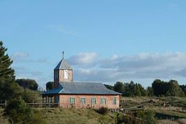
Églises de Chiloé, Chili
Churches of Chiloé (2000)
This UNESCO-listed ensemble of sixteen wooden churches on Chiloé Island is representative of the region. They date from the Spanish era and were built in a distinctive style during the 17th and 18th centuries.
Humberstone et Santa Laura, Chili
Humberstone and Santa Laura (2005)
The two former nitrate works in the Atacama Desert are now abandoned and have become tourist attractions. They are UNESCO-listed.
Sewell, Chili
Sewell (2006)
A UNESCO World Heritage site for its painted wooden buildings, Sewell is home to one of the world’s largest underground mines. The town, now uninhabited, sits at over 2,000 m in the Andes mountain range.
Quartier historique de Valparaiso, Valparaiso, Chili
Historic Quarter of Valparaíso (2003)
The colonial part of the city offers a remarkable example of urban and architectural development from the late 19th century in Latin America. This is why Valparaíso is listed as a UNESCO World Heritage site.

Au nord de Santiago

Église, Arica, Chili
Arica
It’s both a major port city and a beach resort in northern Chile, in the Atacama Desert, known for its beaches and surfing.
Antofagasta, Chili
Antofagasta
This is a major port city on Chile's northern coast, not particularly touristy.
Caldera, Chili
Caldera
It’s one of the coastal resorts in the Atacama region.
Chuquicamata, Chili
Chuquicamata
Located near Calama, this is the world's largest open-pit copper mine. It can be visited.
Humberstone et Santa Laura, Chili
Humberstone and Santa Laura
The two former nitrate works in the Atacama Desert are now abandoned and have become tourist attractions. They are UNESCO-listed.
Iquique, Chili
Iquique
This port city with its vast 19th-century mansions has several beaches. It is also a free trade zone.
La Serena, Chili
La Serena
A major coastal city that draws many visitors thanks to its beaches. It also boasts beautiful 19th-century architecture with numerous churches.
Mano del Desierto, Chili
Hand of the Desert
A hand sculpted in the middle of the desert near Antofagasta. A striking setting for this artwork, standing about ten metres tall and rising from the ground.
Portillo, Chili
Portillo
This is the main and most renowned ski resort in Chile. It is located at an altitude of 2,870 metres on the shores of the Laguna del Inca, on the border with Argentina.
Pukara de Quitor, Chili
Pukara de Quitor
An ancient pre-Columbian fortress near San Pedro de Atacama.
San Pedro de Atacama, Chili
San Pedro de Atacama
This small tourist town in the Atacama Desert, with its adobe houses, has become very popular for its surroundings (archaeological sites, salt flats, geysers, volcanoes, sandboarding, treks).
Santiago du Chili, Chili
Santiago, Chile
Despite its traffic jams and pollution, the Chilean capital remains a lively city with various museums, parks, and interesting buildings against the backdrop of the Andes.
Valparaiso, Chili
Valparaíso
A bay, hills, and vibrant colour define this stunning, lively, and pleasant city near Santiago. Its historic centre is a UNESCO World Heritage site.
Vina del Mar, Chili
Viña del Mar
Located right next to Valparaíso, it is the country's main seaside resort, with plenty of beaches, hotels, and casinos.

Patrimoine naturel

Désert d'Atacama, Chili
Atacama Desert
This location is known as the driest place on Earth. Yet it offers stunning barren landscapes and is home to some of Chile’s most fascinating sites.
Geysers d'El Tatio, Chili
El Tatio Geysers
About a hundred kilometres from San Pedro de Atacama, these are 80 active geysers set in a desert landscape, with volcanoes in the background, at over 4,000 m above sea level.
Lacs Miscanti et Miniques, Chili
Lakes Miscanti and Miniques
These are two beautiful high-altitude lakes in the Los Flamencos Reserve, set in a stunning landscape south of San Pedro de Atacama. Large colonies of Andean flamingos nest here.
Licancabur, Bolivie
Licancabur
It’s a striking 5,916 m volcano on the Chile-Bolivia border, and you can climb it from the Bolivian side.
Parc national Fray Jorge, Chili
Fray Jorge National Park
This small coastal park boasts lush vegetation that makes it truly charming. Hiking is available here.
Parc national Lauca, Chili
Lauca National Park
This park in the far north of Chile offers magnificent desolate landscapes with high-altitude lakes set against a backdrop of volcanoes—the Andes as you imagine them. It’s one of the country’s "must-see" tourist sites.
Parc national Pan de Azucar, Chili
Pan de Azúcar National Park
A beautiful desert location on the northern coast where you can see guanacos and various marine mammals.
Puritama, Chili
Puritama Hot Springs
These are hot springs located northeast of San Pedro de Atacama.
Réserve nationale Los Flamencos, Chili
Los Flamencos National Reserve
This 740 km² site, bordering Argentina and Bolivia, is home to several salt deserts, including the famous Atacama Salt Flat, as well as the renowned Moon Valley. The rugged landscapes are stunning and make it a must-visit for any trip.
Vallée de la lune, Chili
Moon Valley
This magnificent high-altitude desert area, just a few kilometres from San Pedro de Atacama, is part of the Los Flamencos National Reserve. It offers breathtaking lunar landscapes.

Au sud de Santiago

Archipel Juan Fernandez, Chili
Juan Fernández Archipelago
A small archipelago of three islands over 600 km off the Chilean coast, featuring beautiful landscapes.
Carretera Austral, Chili
Carretera Austral
This is the name of Route 7, connecting Puerto Montt to Villa O'Higgins through Patagonia. Over time, it has become a scenic tourist route, highly appreciated for its setting and environment.
Chiloé, Chili
Chiloé
It is the largest island in Chile. Known for its beautiful landscapes and especially its colorful traditional villages, whose wooden churches are UNESCO-listed. You can hike here, though the island tends to be quite rainy.
Concepcion, Chili
Concepcion
It's the second-largest urban area in Chile, not particularly touristy, about 500 km south of Santiago.
Pucon, Chili
Pucón
Located on the eastern shore of Lake Villarrica, Pucón is a highly popular lakeside resort. You can ski or trek on the slopes of the nearby Villarrica Volcano.
Puerto Montt, Chili
Puerto Montt
The major city in the south and a key transport hub, including boats and cruises. Puerto Montt also marks the start of Chilean Patagonia.
Puerto Natales, Chili
Puerto Natales
The small town in Chile’s far south typically serves as a base for exploring Torres del Paine National Park. It is also the ferry terminus for the stunning journey from Puerto Montt.
Puerto Varas, Chili
Puerto Varas
By the lake, next to Puerto Montt, the town's architecture was influenced by the strong German immigration in the region.
Puerto Williams, Chili
Puerto Williams
On Navarino Island, at the southernmost tip of the country, it is the southernmost village in the world (Ushuaia in Argentina being the southernmost city).
Punta Arenas, Chili
Punta Arenas
The largest city in Chile's far south and a great base for exploring the surrounding area (landscapes, marine wildlife, treks, boat trips). You can also reach Ushuaia (Argentina) from the city.
Sewell, Chili
Sewell
A UNESCO World Heritage site for its painted wooden buildings, Sewell is home to one of the world’s largest underground mines. The town, now uninhabited, sits at over 2,000 m in the Andes mountain range.
Viejo vagon de trenes museo ferroviario, Temuco, Chili
Temuco
The city is primarily interesting for its museums and monuments dedicated to Mapuche culture.
Valdivia, Chili
Valdivia
Near this port city, you’ll find an entire network of 17th-century Spanish forts, with ruins still visible today.
Old wooden chapel, museum, Villa O'Higgins, Chili
Villa O'Higgins
This Patagonian village is known only as the endpoint of the "famous" tourist route Carretera Austral.
Villarrica
On the shore of the lake of the same name, the town is a great base for exploring the surrounding area (lakes, volcanoes, waterfalls, skiing, rafting, treks).

Patrimoine naturel

Canal de Beagle, Argentine
Beagle Channel
It’s a narrow strait between the southern part of the main island of Argentine or Chilean Tierra del Fuego and smaller surrounding islands. You can take stunning boat or kayak trips here to explore the landscapes and wildlife.
Senoret Channel
A network of navigable waterways along the Patagonian coast and its fjords. It is particularly explored via the ferry connecting Puerto Montt and Puerto Natales.
Détroit de Magellan, Chili
Strait of Magellan
This is the strait between continental Chile and the northern part of the main island of Tierra del Fuego. You can take boat trips here through stunning landscapes.
Lago Fagnano, Argentine
Lake Fagnano
Large lake north of Ushuaia straddling Argentina and Chile. It can be explored on foot or by boat.
Parc national Bernardo O'Higgins, Chili
Bernardo O'Higgins National Park
This is Chile's largest national park. It is home to numerous glaciers and is only accessible by boat or helicopter.
Parc national Huerquehue, Chili
Huerquehue National Park
This pretty mountainous park of lakes, waterfalls, and forests, not far from Pucón, is a great place for hiking in both winter and summer.
Parc national Laguna del Laja, Chili
Laguna del Laja National Park
Against a volcanic backdrop, this is a rather pretty high-altitude park where you can trek.
Parc national Laguna San Rafaël, Chili
Laguna San Rafael National Park
North of O'Higgins Park, this magnificent site is home to several fjords and, most notably, the San Rafael Glacier, one of the region's most significant. You can hike and take small cruises here.
Parc national Puyehue, Chili
Puyehue National Park
This Andean park is one of the most visited in the country. You can hike and enjoy various outdoor activities (including skiing) amid lakes, forests, and volcanoes.
Parc national Queulat, Chili
Queulat National Park
A stunning site with fjords, waterfalls, and multiple hiking opportunities.
Parc national Radal Siete Tazas, Chili
Radal Siete Tazas National Park
Located south of Santiago, it’s a rather pretty spot with many small lakes and waterfalls for hiking.
Parc national Torres del Paine, Chili
Torres del Paine National Park
This is a stunning park world-famous for its diverse landscapes, forests, lakes and waterfalls, glaciers, and numerous trekking opportunities.
Parc national Vicente Perez Rosales, Chili
Vicente Pérez Rosales National Park
This natural area bordering Puyehue Park is also ideal for hiking and outdoor activities.
Parc national Villarrica, Chili
Villarrica National Park
Near the city of the same name, this high-altitude park features forests, mountains, and volcanoes. Hiking is available.
Vallée de Cochamo, Chili
Cochamó Valley
The valley is prized by climbers from around the world for its high rock walls, many of which exceed 1,000 metres. It’s also a great place for hiking.

Must-see & highly recommended

★★★★

Atacama Desert

This location is known as the driest place on Earth. Yet it offers stunning barren landscapes and is home to some of Chile’s most…
★★★★

Lauca National Park

This park in the far north of Chile offers magnificent desolate landscapes with high-altitude lakes set against a backdrop of…
★★★★

Torres del Paine National Park

This is a stunning park world-famous for its diverse landscapes, forests, lakes and waterfalls, glaciers, and numerous trekking…
★★★★

Los Flamencos National Reserve

This 740 km² site, bordering Argentina and Bolivia, is home to several salt deserts, including the famous Atacama Salt Flat, as well as the…
★★★★

Moon Valley

This magnificent high-altitude desert area, just a few kilometres from San Pedro de Atacama, is part of the Los Flamencos National Reserve…
★★★★

Valparaíso

A bay, hills, and vibrant colour define this stunning, lively, and pleasant city near Santiago. Its historic centre is a UNESCO World…

Recommended

★★★

Beagle Channel

It’s a narrow strait between the southern part of the main island of Argentine or Chilean Tierra del Fuego and smaller surrounding…
★★★

Senoret Channel

A network of navigable waterways along the Patagonian coast and its fjords. It is particularly explored via the ferry connecting Puerto…
★★★

Carretera Austral

This is the name of Route 7, connecting Puerto Montt to Villa O'Higgins through Patagonia. Over time, it has become a scenic tourist route…
★★★

Inca Trails of the Andes

Also known as Qhapaq Ñan. These are the remains of the roads (23,000 km) built by the Incas over several centuries to consolidate their…
★★★

Chiloé

It is the largest island in Chile. Known for its beautiful landscapes and especially its colorful traditional villages, whose wooden…
★★★

Strait of Magellan

This is the strait between continental Chile and the northern part of the main island of Tierra del Fuego. You can take boat trips here…
★★★

El Tatio Geysers

About a hundred kilometres from San Pedro de Atacama, these are 80 active geysers set in a desert landscape, with volcanoes in the…
★★★

Bernardo O'Higgins National Park

This is Chile's largest national park. It is home to numerous glaciers and is only accessible by boat or helicopter.
★★★

Laguna San Rafael National Park

North of O'Higgins Park, this magnificent site is home to several fjords and, most notably, the San Rafael Glacier, one of the region's…
★★★

Historic Quarter of Valparaíso

The colonial part of the city offers a remarkable example of urban and architectural development from the late 19th century in Latin…

Worth a look / Other

★★

Juan Fernández Archipelago

A small archipelago of three islands over 600 km off the Chilean coast, featuring beautiful landscapes.
★★

Arica

It’s both a major port city and a beach resort in northern Chile, in the Atacama Desert, known for its beaches and surfing.
★★

Churches of Chiloé

This UNESCO-listed ensemble of sixteen wooden churches on Chiloé Island is representative of the region. They date from the Spanish era and…
★★

Humberstone and Santa Laura

The two former nitrate works in the Atacama Desert are now abandoned and have become tourist attractions. They are UNESCO-listed.
★★

La Serena

A major coastal city that draws many visitors thanks to its beaches. It also boasts beautiful 19th-century architecture with numerous…
★★

Lakes Miscanti and Miniques

These are two beautiful high-altitude lakes in the Los Flamencos Reserve, set in a stunning landscape south of San Pedro de Atacama. Large…
★★

Licancabur

It’s a striking 5,916 m volcano on the Chile-Bolivia border, and you can climb it from the Bolivian side.
★★

Huerquehue National Park

This pretty mountainous park of lakes, waterfalls, and forests, not far from Pucón, is a great place for hiking in both winter and summer.
★★

Pan de Azúcar National Park

A beautiful desert location on the northern coast where you can see guanacos and various marine mammals.
★★

Puyehue National Park

This Andean park is one of the most visited in the country. You can hike and enjoy various outdoor activities (including skiing) amid…
★★

Queulat National Park

A stunning site with fjords, waterfalls, and multiple hiking opportunities.
★★

Vicente Pérez Rosales National Park

This natural area bordering Puyehue Park is also ideal for hiking and outdoor activities.
★★

Villarrica National Park

Near the city of the same name, this high-altitude park features forests, mountains, and volcanoes. Hiking is available.
★★

Pucón

Located on the eastern shore of Lake Villarrica, Pucón is a highly popular lakeside resort. You can ski or trek on the slopes of the nearby…
★★

San Pedro de Atacama

This small tourist town in the Atacama Desert, with its adobe houses, has become very popular for its surroundings (archaeological sites…
★★

Santiago, Chile

Despite its traffic jams and pollution, the Chilean capital remains a lively city with various museums, parks, and interesting buildings…
★★

Cochamó Valley

The valley is prized by climbers from around the world for its high rock walls, many of which exceed 1,000 metres. It’s also a great…
★

Antofagasta

This is a major port city on Chile's northern coast, not particularly touristy.
★

Caldera

It’s one of the coastal resorts in the Atacama region.
★

Chuquicamata

Located near Calama, this is the world's largest open-pit copper mine. It can be visited.
★

Concepcion

It's the second-largest urban area in Chile, not particularly touristy, about 500 km south of Santiago.
★

Iquique

This port city with its vast 19th-century mansions has several beaches. It is also a free trade zone.
★

Lake Fagnano

Large lake north of Ushuaia straddling Argentina and Chile. It can be explored on foot or by boat.
★

Hand of the Desert

A hand sculpted in the middle of the desert near Antofagasta. A striking setting for this artwork, standing about ten metres tall and…
★

Fray Jorge National Park

This small coastal park boasts lush vegetation that makes it truly charming. Hiking is available here.
★

Laguna del Laja National Park

Against a volcanic backdrop, this is a rather pretty high-altitude park where you can trek.
★

Radal Siete Tazas National Park

Located south of Santiago, it’s a rather pretty spot with many small lakes and waterfalls for hiking.
★

Portillo

This is the main and most renowned ski resort in Chile. It is located at an altitude of 2,870 metres on the shores of the Laguna del Inca…
★

Puerto Montt

The major city in the south and a key transport hub, including boats and cruises. Puerto Montt also marks the start of Chilean Patagonia.
★

Puerto Natales

The small town in Chile’s far south typically serves as a base for exploring Torres del Paine National Park. It is also the ferry…
★

Puerto Varas

By the lake, next to Puerto Montt, the town's architecture was influenced by the strong German immigration in the region.
★

Puerto Williams

On Navarino Island, at the southernmost tip of the country, it is the southernmost village in the world (Ushuaia in Argentina being the…
★

Pukara de Quitor

An ancient pre-Columbian fortress near San Pedro de Atacama.
★

Punta Arenas

The largest city in Chile's far south and a great base for exploring the surrounding area (landscapes, marine wildlife, treks, boat trips)…
★

Puritama Hot Springs

These are hot springs located northeast of San Pedro de Atacama.
★

Sewell

A UNESCO World Heritage site for its painted wooden buildings, Sewell is home to one of the world’s largest underground mines. The…
★

Temuco

The city is primarily interesting for its museums and monuments dedicated to Mapuche culture.
★

Valdivia

Near this port city, you’ll find an entire network of 17th-century Spanish forts, with ruins still visible today.
★

Villa O'Higgins

This Patagonian village is known only as the endpoint of the "famous" tourist route Carretera Austral.
★

Villarrica

On the shore of the lake of the same name, the town is a great base for exploring the surrounding area (lakes, volcanoes, waterfalls…
★

Viña del Mar

Located right next to Valparaíso, it is the country's main seaside resort, with plenty of beaches, hotels, and casinos.

Arica

It’s both a major port city and a beach resort in northern Chile, in the Atacama Desert, known for its beaches and surfing.

Overview of Arica

It’s both a major port city and a beach resort in northern Chile, in the Atacama Desert, known for its beaches and surfing.

Key Facts

  • Type of place: large city.
  • Tourist interest: (worth seeing).
  • Location:
  • Distances:
  • Local time: Heure : 13152.
  • Population: 239,710 (2016).
  • Area: 4,799 km².
  • Altitude: sea level.

History of Arica

What to See and Do in Arica

In the Surrounding Area

Climate and Weather

Transportation

Getting There

Getting Around

Accommodation

Dining

Useful Addresses

Additional Information

View guide page: Arica

Antofagasta

This is a major port city on Chile's northern coast, not particularly touristy.

Overview of Antofagasta

This is a major port city on Chile's northern coast, not particularly touristy.

Key facts

  • Type of place: landmark town.
  • Tourist interest: (worth a stop if you are in the area).
  • Location:
  • Distances:
  • Local time: Heure : 13153.
  • Population: 402,444 (2015).
  • Area: 30,718 km².
  • Altitude: sea level.

History of Antofagasta

What to see and do in Antofagasta

In the surrounding area

Climate and weather

Transportation

Getting there

Getting around

Accommodation

Food

Useful addresses

Further information

View guide page: Antofagasta

Caldera

It’s one of the coastal resorts in the Atacama region.

Overview of Caldera

It’s one of the coastal resorts in the Atacama region.

Key Facts

  • Type of place: small town.
  • Tourist interest: (worth a stop if you are in the area).
  • Location:
  • Distances:
  • Local time: Heure : 13154.
  • Population: 17,662 inhabitants (2017).
  • Area: 4,667 km².
  • Altitude: sea level.

History of Caldera

What to see and do in Caldera

In the surrounding area

Climate and weather in Caldera

Transport

Getting there

Getting around

Accommodation

Eating

Useful addresses

Further information

View guide page: Caldera

Chuquicamata

Located near Calama, this is the world's largest open-pit copper mine. It can be visited.

Overview of Chuquicamata

Located near Calama, this is the world's largest open-pit copper mine. It can be visited.

  • Tourist interest: (worth a stop if you are in the area).

History of Chuquicamata

What to see and do

Practical information

  • Location:
  • Local time: Heure : 13155.
  • Opening hours:
  • Price:

Transport

Sleeping and eating

What to see nearby

Additional information

View guide page: Chuquicamata

Humberstone and Santa Laura

The two former nitrate works in the Atacama Desert are now abandoned and have become tourist attractions. They are UNESCO-listed.

Overview of Humberstone and Santa Laura

The two former nitrate works in the Atacama Desert are now abandoned and have become tourist attractions. They are UNESCO-listed.

  • Tourist interest: (worth seeing).

History of Humberstone and Santa Laura

What to see and do

Practical information

  • Location:
  • Address: km 47 A-16, Pozo Almonte, Región de Tarapacá.
  • Opening hours:
  • Price:
  • How to get there:

Nearby attractions

  1. == In addition
View guide page: Humberstone and Santa Laura

Iquique

This port city with its vast 19th-century mansions has several beaches. It is also a free trade zone.

Overview of Iquique

This port city with its vast 19th-century mansions has several beaches. It is also a free trade zone.

Key Facts

  • Type of place: city.
  • Tourist interest: (worth a stop if you are in the area).
  • Location:
  • Distances:
  • Local time: Heure : 13157.
  • Population: 191,468 (2017).
  • Area: 2,242 km².
  • Altitude: sea level.

History of Iquique

What to See and Do in Iquique

In the Surrounding Area

Climate and Weather

Transportation

Getting There

Getting Around

Accommodation

Eating

Useful Addresses

Further Information

View guide page: Iquique

Portillo

This is the main and most renowned ski resort in Chile. It is located at an altitude of 2,870 metres on the shores of the Laguna del Inca, on the border with Argentina.

Overview of Portillo

This is the main and most renowned ski resort in Chile. It is located at an altitude of 2,870 metres on the shores of the Laguna del Inca, on the border with Argentina.

Key Facts

  • Type of place: ski resort.
  • Tourist interest: (worth a stop if you are in the area).
  • Mountain range: Chilean Andes.
  • Associated resorts:
  • Population:
  • Altitude: from 2,548 to 3,310 m.

Resort Environment

Climate and Weather

Precautions

Facilities and Activities

Ski Area

  • Opening period:
  • Number of slopes: 17.
  • Length of slopes: 35 km.
  • Cross-country ski trails:

Other Winter Activities

Summer Activities

Practical Information

  • Location:
  • How to get there:
  • Distances:

Accommodation and Dining

Entertainment

What to See and Do Nearby

Additional Information

View guide page: Portillo

Pukara de Quitor

An ancient pre-Columbian fortress near San Pedro de Atacama.

Overview of Pukara de Quitor

This is an ancient pre-Columbian fortress near San Pedro de Atacama.

  • Tourist interest: (worth a stop if you are in the area).

History of Pukara de Quitor

What to see and do

Practical information

  • Location:
  • Local time: Heure : 13160.
  • Opening hours:
  • Price:
  • Website:

Transport

Sleeping and eating

Nearby attractions

  1. == En complément
View guide page: Pukara de Quitor

San Pedro de Atacama

This small tourist town in the Atacama Desert, with its adobe houses, has become very popular for its surroundings (archaeological sites, salt flats, geysers, volcanoes, sandboarding, treks).

Overview of San Pedro de Atacama

This small tourist town in the Atacama Desert, with its adobe houses, has become very popular for its surroundings (archaeological sites, salt flats, geysers, volcanoes, sandboarding, treks).

Key facts

  • Type of place: small town.
  • Tourist interest: (worth seeing).
  • Location:
  • Distances:
  • Local time: Heure : 13161.
  • Population: 5,605 inhabitants (2012).
  • Area: 23,439 km².
  • Altitude: 2,438 m.

History of San Pedro

What to see and do in San Pedro

In the surrounding area

Climate and weather

Transport

Getting there

Getting around

Accommodation

Eating

Useful addresses

Further information

View guide page: San Pedro de Atacama

Santiago, Chile

Despite its traffic jams and pollution, the Chilean capital remains a lively city with various museums, parks, and interesting buildings against the backdrop of the Andes. Introduction to Santiago, Chile History, Culture and Society of Santiago de Chile Santiago de Chile's Cuisine Climate and Weather in Santiago, Chile What to See in Santiago, Chile Things to Do in Santiago, Chile Tips for Santiago, Chile Flying to Santiago, Chile Getting to Santiago, Chile by Land Getting Around Santiago, Chile Accommodation in Santiago, Chile Other practical information for Santiago, Chile Living in Santiago, Chile

Further information

View guide page: Santiago, Chile

Introduction to Santiago, Chile

Overview of Santiago, Chile

Despite its traffic jams and pollution, the Chilean capital remains a lively city with various museums, parks, and interesting buildings set against the backdrop of the Andes.

Key Facts

  • Type of place: main city.
  • Tourist interest: (worth seeing).
  • Location:
  • Latitude/longitude:
  • Distances:
  • Local time: Heure : 13162.
  • Population: 6,310,000 inhabitants and over 7.1 million for the metropolitan area (2017).
  • Area: 670 km².
  • Altitude: 570 m.

Tourism

Travel Essentials

  • Tourist interest: (worth seeing).
  • By air:
  • Daily backpacker budget:
  • Best for accommodation:
  • Best for getting around:
  • Best time for climate/crowds/prices:

Additional Information

View guide page: Introduction to Santiago, Chile

Climate and Weather in Santiago, Chile

Climate Overview

Best Time to Visit Santiago, Chile

Jan.Feb.Mar.Apr.MayJun.Jul.Aug.Sep.Oct.Nov.Dec.
Climate

Climate and Forecast

Additional Information

View guide page: Climate and Weather in Santiago, Chile

Flying to Santiago, Chile

Santiago, Chile Airport

Airport details

  • Name: Aeropuerto Comodoro Arturo Merino Benítez.
  • IATA code: SCLK
  • Hub:
  • Number of terminals:
  • Passenger capacity/year:
  • Passenger traffic: 21,426,871 (2017).
  • Distance from city centre: 15 km northwest of the city.

Services

Sleeping at the airport

Transport to the city centre

  • Public transport:
  • Taxis:

Other nearby airports

From the rest of the country

From the rest of the Americas

From Europe

From Asia-Pacific

Additional information

View guide page: Flying to Santiago, Chile

Valparaíso

A bay, hills, and vibrant colour define this stunning, lively, and pleasant city near Santiago. Its historic centre is a UNESCO World Heritage site. Overview of Valparaíso Valparaíso Climate and Weather What to See in Valparaíso Things to Do in Valparaíso Getting to Valparaiso Getting Around Valparaiso Accommodation and Dining in Valparaíso Living in Valparaiso

Further reading

View guide page: Valparaíso

Overview of Valparaíso

Overview of Valparaíso

A bay, hills, and vibrant colours make this superb, dynamic, and pleasant city near Santiago a must-see. Its historic centre is even a UNESCO World Heritage site.

Key facts

  • Type of place: large city.
  • Tourist interest: (must-see or highly recommended).
  • Location:
  • Distances:
  • Local time: Heure : 13163.
  • Population: 296,655 (2017).
  • Area: 401 km².
  • Altitude: sea level.

History of Valparaíso

Precautions

Useful addresses

  • Tourist office:

Services

  • Local agencies:
  • Banks:
  • Hospital:
  • Internet:
  • Laundries:
  • Vehicle rental:
  • Post office:
View guide page: Overview of Valparaíso

Valparaíso Climate and Weather

Climate Overview

Best Time to Visit Valparaíso

Jan.Feb.Mar.Apr.MayJun.Jul.Aug.Sep.Oct.Nov.Dec.
Climate

Climate and Forecast

Additional Information

View guide page: Valparaíso Climate and Weather

What to See in Valparaíso

Overview

UNESCO World Heritage Site

Quartier historique de Valparaiso, Valparaiso, Chili
Historic Quarter of Valparaíso
The colonial part of the city offers a remarkable example of urban and architectural development from the late 19th century in Latin America. This is why Valparaíso is listed as a UNESCO World Heritage site.

Neighborhoods

Sites, Monuments, and Architectural Ensembles

Religious Buildings

Museums

Parks and Gardens

In the Surrounding Area

Further Reading

View guide page: What to See in Valparaíso

Historic Quarter of Valparaíso

The colonial part of the city offers a remarkable example of urban and architectural development from the late 19th century in Latin America. This is why Valparaíso is listed as a UNESCO World Heritage site.

Overview of the Quarter

The colonial part of the city offers a remarkable example of urban and architectural development from the late 19th century in Latin America. This is why Valparaíso is listed as a UNESCO World Heritage site.

  • Tourist interest: (recommended).

History of the Quarter

What to See

What to Do

Events and Activities

Practical Information

  • Location:
  • How to get there:
  • How to get around:

Where to Eat

Where to Stay

What to See Nearby

  1. == Further Information
View guide page: Historic Quarter of Valparaíso

Getting to Valparaiso

By air

Due to its geographical proximity to Santiago, Valparaiso does not have its own airport. The capital's airport, about a hundred kilometres away, handles flights to and from the city.

By land

By bus

By train

Distances

By sea

Ferries

Cargo

Cruises

Sailboats

View guide page: Getting to Valparaiso

Viña del Mar

Located right next to Valparaíso, it is the country's main seaside resort, with plenty of beaches, hotels, and casinos.

Overview of Viña del Mar

Located right next to Valparaíso, it is the country's main seaside resort, with plenty of beaches, hotels, and casinos.

Key Facts

  • Type de lieu: city.
  • Intérêt touristique: (worth a stop if you are in the area).
  • Localisation:
  • Distances:
  • Heure locale: Heure : 13164.
  • Population: 334,248 inhabitants (2017).
  • Superficie: 121 km².
  • Altitude: sea level.

History of Viña del Mar

What to See and Do in Viña del Mar

In the Surrounding Area

Climate and Weather

Transportation

Getting There

Getting Around

Where to Stay

Where to Eat

Useful Addresses

Additional Information

View guide page: Viña del Mar

El Tatio Geysers

About a hundred kilometres from San Pedro de Atacama, these are 80 active geysers set in a desert landscape, with volcanoes in the background, at over 4,000 m above sea level.

Overview of El Tatio Geysers

About a hundred kilometres from San Pedro de Atacama, there are 80 active geysers set in a desert landscape, with volcanoes in the background, at over 4,000 m above sea level.

Key details

  • Type of place: hot spring.
  • Tourist interest: (recommended).
  • Features:
  • Location:
  • Area:
  • Altitude: 4,320 m.

Site environment

Wildlife and vegetation

What to see and do

In the surrounding area

Climate and weather

Precautions

Getting there

Sleeping and eating

Further information

View guide page: El Tatio Geysers

Lakes Miscanti and Miniques

These are two beautiful high-altitude lakes in the Los Flamencos Reserve, set in a stunning landscape south of San Pedro de Atacama. Large colonies of Andean flamingos nest here.

Overview of the lakes

These are two beautiful high-altitude lakes in the Los Flamencos Reserve, set in a stunning landscape south of San Pedro de Atacama. Large colonies of Andean flamingos nest here.

Key details

  • Type of place: lake.
  • Tourist interest: (worth seeing).
  • Characteristics:
  • Area: 13.4 km² (Miscanti) and 1.6 km² (Miniques).
  • Altitude: 4,120 m.

Environment

Wildlife and flora

Climate and weather

Precautions

What to see and do

Practical information

  • Location:
  • Distances:
  • Website:

Getting there

Accommodation and dining

Nearby attractions

Additional information

View guide page: Lakes Miscanti and Miniques

Fray Jorge National Park

This small coastal park boasts lush vegetation that makes it truly charming. Hiking is available here.

Overview of Fray Jorge Park

This small coastal park boasts lush vegetation that makes it truly charming. Hiking is available here.

Key Details

  • Type of place: national park.
  • Tourist interest: (worth a stop if you are in the area).
  • Features:
  • Local time: Heure : 13167
  • Annual visitors:
  • Area: 99.59 km².
  • Altitude: sea level.

Environment

Park Landscape

Wildlife and Flora

Climate and Weather

Precautions

What to See and Do

Practical Information

  • Location:
  • Distances:
  • Opening period:
  • Rates:

Getting There

Getting Around

Accommodation and Dining

Nearby Attractions

  1. == En complément
View guide page: Fray Jorge National Park

Lauca National Park

This park in the far north of Chile offers magnificent desolate landscapes with high-altitude lakes set against a backdrop of volcanoes—the Andes as you imagine them. It’s one of the country’s "must-see" tourist sites.

Overview of Lauca National Park

This park, in the far north of Chile, offers magnificent desolate landscapes with high-altitude lakes set against a backdrop of volcanoes—the Andes as you picture them. It’s one of the country’s "must-see" tourist sites.

Key facts

  • Type of place: national park.
  • Tourist interest: (must-see or highly recommended).
  • Features:
  • Local time: Heure : 13168
  • Annual visitors:
  • Area: 1,378.83 km².
  • Altitude: from 3,200 to 6,342 m.

Environment

Landscape of the park

Wildlife and vegetation

Climate and weather

Precautions

What to see

What to do

Practical information

  • Location:
  • Distances:
  • Opening period:
  • Rates:

Getting there

Getting around

Sleeping and eating

Nearby attractions

Further reading

View guide page: Lauca National Park

Pan de Azúcar National Park

A beautiful desert location on the northern coast where you can see guanacos and various marine mammals.

Overview of Pan de Azúcar National Park

This is a beautiful desert location on the northern coast of Chile where you can see guanacos and various marine mammals.

Key Facts

  • Type of place: national park.
  • Tourist interest: (worth seeing).
  • Features:
  • Local time: Heure : 13169
  • Annual visitors:
  • Area: 437.54 km².
  • Altitude: sea level.

Environment

Landscape of the Park

Wildlife and Flora

Climate and Weather

Precautions

What to See

What to Do

Practical Information

  • Location:
  • Distances:
  • Opening period:
  • Rates:

Getting There

Getting Around

Sleeping and Eating

Nearby Attractions

Further Information

View guide page: Pan de Azúcar National Park

Puritama Hot Springs

These are hot springs located northeast of San Pedro de Atacama.

Overview of Puritama

These are hot springs located northeast of San Pedro de Atacama.

Key Details

  • Type of place: hot spring.
  • Tourist interest: (worth a stop if you are in the area).
  • Features:
  • Location:
  • Area:
  • Altitude: 3,475 m.

Site Environment

Wildlife and Flora

What to See and Do

Nearby Attractions

Climate and Weather

Precautions

Getting There

Sleeping and Eating

  1. == In Addition
View guide page: Puritama Hot Springs

Moon Valley

This magnificent high-altitude desert area, just a few kilometres from San Pedro de Atacama, is part of the Los Flamencos National Reserve. It offers breathtaking lunar landscapes.

Overview of Moon Valley

This magnificent high-altitude desert area, just a few kilometres from San Pedro de Atacama, is part of the Los Flamencos National Reserve. It offers breathtaking lunar landscapes.

Key details

  • Type of place: desert.
  • Tourist interest: (must-see or highly recommended).
  • Features:
  • Area:
  • Altitude:

Environment

Wildlife and vegetation

Climate and weather

Precautions

What to see

What to do

Practical information

  • Location:
  • Distances:

Getting there

Getting around

Sleeping and eating

What to see nearby

Further reading

View guide page: Moon Valley

Juan Fernández Archipelago

A small archipelago of three islands over 600 km off the Chilean coast, featuring beautiful landscapes.

Overview of the Archipelago

This is a small archipelago over 600 km off the Chilean coast, featuring beautiful landscapes. It consists of three islands: Robinson Crusoe Island (49.7 km²), the only inhabited one and the closest to the South American continent, along with Alejandro Selkirk Island and Santa Clara Island.

Key Facts

  • Type of place: archipelago.
  • Tourist interest: (worth seeing).
  • Location:
  • Local time: Heure : 13173
  • Number of islands: 3.
  • Main island: Isla Robinson Crusoe.
  • Population: 1,083 inhabitants (2014), only on Robinson Crusoe Island.
  • Area: 99.6 km².
  • Highest point: Los Innocentes (1,650 m) on Alejandro Selkirk Island.
  • Coastline:

History of the Juan Fernández Archipelago

Environment

Wildlife and Flora

Precautions

What to See and Do

In the Surroundings

Climate and Weather

Transportation

Getting There

Getting Around

Accommodation

Food

Useful Addresses

Further Information

View guide page: Juan Fernández Archipelago

Chiloé

It is the largest island in Chile. Known for its beautiful landscapes and especially its colorful traditional villages, whose wooden churches are UNESCO-listed. You can hike here, though the island tends to be quite rainy.

Overview of Chiloé

It is the largest island in Chile. Forming an archipelago with a few other small neighboring islands, it is known for its beautiful landscapes and especially its colorful traditional villages, whose wooden churches are UNESCO-listed. You can hike on this island, though it tends to be quite rainy.

Key Facts

  • Type of place: island.
  • Tourist interest: (recommended).
  • Location:
  • Local time: Heure : 13174
  • Main town: Castro (42,000 inhabitants).
  • Population: 167,659 inhabitants (2012).
  • Area: 8,394 km².
  • Highest point: Isla San Pedro (960 m).
  • Coastline:

History of Chiloé

Island Environment

Wildlife and Flora

Precautions

What to See

Églises de Chiloé, Chili
Churches of Chiloé
This UNESCO-listed ensemble of sixteen wooden churches on Chiloé Island is representative of the region. They date from the Spanish era and were built in a distinctive style during the 17th and 18th centuries.

In the Surrounding Area

What to Do

Climate and Weather in Chiloé

Transportation

Getting There

Getting Around

Accommodation

Food

Useful Addresses

Further Reading

View guide page: Chiloé

Churches of Chiloé

This UNESCO-listed ensemble of sixteen wooden churches on Chiloé Island is representative of the region. They date from the Spanish era and were built in a distinctive style during the 17th and 18th centuries.

Overview of the Churches of Chiloé

This UNESCO-listed ensemble of sixteen wooden churches on Chiloé Island is representative of the region. They date from the Spanish era and were built (in Castro and its surroundings) in a distinctive style during the 17th and 18th centuries.

  • Tourist interest: (worth seeing).

History of the Churches of Chiloé

What to see and do

Practical information

  • Location:
  • Opening hours:
  • Admission fee:
  • How to get there:

What to see nearby

  1. == In addition
View guide page: Churches of Chiloé

Pucón

Located on the eastern shore of Lake Villarrica, Pucón is a highly popular lakeside resort. You can ski or trek on the slopes of the nearby Villarrica Volcano.

Overview of Pucón

Located on the eastern shore of Lake Villarrica, Pucón is a highly popular lakeside resort. You can ski or trek on the slopes of the nearby Villarrica Volcano.

Key Facts

  • Type of place: small town.
  • Tourist interest: (worth seeing).
  • Location:
  • Distances:
  • Local time: Heure : 13176.
  • Population: 37,168 (2016).
  • Area: 1,249 km².
  • Altitude: 227 m.

History of Pucón

What to See and Do in Pucón

In the Surrounding Area

Climate and Weather in Pucón

Transportation

Getting There

Getting Around

Accommodation

Dining

Useful Addresses

Further Information

View guide page: Pucón

Puerto Montt

The major city in the south and a key transport hub, including boats and cruises. Puerto Montt also marks the start of Chilean Patagonia.

Overview of Puerto Montt

It’s the major city in southern Chile and a key transport hub, including boats and cruises (especially to Puerto Natales). Puerto Montt also marks the start of Chilean Patagonia.

Key facts

  • Type of place: city.
  • Tourist interest: (worth a stop if you are in the area).
  • Location:
  • Distances:
  • Local time: Heure : 13177.
  • Population: 245,902 (2017).
  • Area: 1,673 km².
  • Altitude: sea level.

History of Puerto Montt

What to see and do in Puerto Montt

In the surrounding area

Climate and weather

Transport

Getting there

Getting around

Accommodation

Food

Useful addresses

Further reading

View guide page: Puerto Montt

Puerto Natales

The small town in Chile’s far south typically serves as a base for exploring Torres del Paine National Park. It is also the ferry terminus for the stunning journey from Puerto Montt.

Introduction to Puerto Natales

The small town in Chile’s far south typically serves as a base for exploring Torres del Paine National Park. It is also the terminus for the ferry making the stunning journey from Puerto Montt.

Key Facts

  • Type of place: small town.
  • Tourist interest: (worth a stop if you are in the area).
  • Location:
  • Distances:
  • Local time: Heure : 13178.
  • Population: 21,477 (2017).
  • Area: 48,974 km².
  • Altitude: sea level.

History of Puerto Natales

What to See and Do in Puerto Natales

In the Surrounding Area

Climate and Weather

Transportation

Getting There

Getting Around

Accommodation

Dining

Useful Addresses

Further Information

View guide page: Puerto Natales

Puerto Varas

By the lake, next to Puerto Montt, the town's architecture was influenced by the strong German immigration in the region.

Overview of Puerto Varas

By the lakeside, next to Puerto Montt, the town's architecture was influenced by the strong German immigration in the region.

Key Facts

  • Type of place: small town.
  • Tourist interest: (worth a stop if you are in the area).
  • Location:
  • Distances:
  • Local time: Heure : 13179.
  • Population: 44,578 (2017).
  • Area: 4,064 km².
  • Altitude: 56 m.

History of Puerto Varas

What to See and Do in Puerto Varas

In the Surrounding Area

Climate and Weather

Transportation

Getting There

Getting Around

Accommodation

Dining

Useful Addresses

Additional Information

View guide page: Puerto Varas

Puerto Williams

On Navarino Island, at the southernmost tip of the country, it is the southernmost village in the world (Ushuaia in Argentina being the southernmost city).

Overview of Puerto Williams

On Navarino Island, at the southernmost tip of Chile, it is the southernmost village in the world (Ushuaia in Argentina being the southernmost city).

Key Facts

  • Type of place: village.
  • Tourist interest: (worth a stop if you are in the area).
  • Location:
  • Distances:
  • Local time: Heure : 13180.
  • Population: 2,200 inhabitants (2016).
  • Area:
  • Altitude: sea level.

History of Puerto Williams

What to See and Do in Puerto Williams

In the Surrounding Area

Climate and Weather

Transportation

Getting There

Getting Around

Accommodation

Eating Out

Useful Addresses

Further Information

View guide page: Puerto Williams

Punta Arenas

The largest city in Chile's far south and a great base for exploring the surrounding area (landscapes, marine wildlife, treks, boat trips). You can also reach Ushuaia (Argentina) from the city.

Overview of Punta Arenas

It's the largest city in Chile's far south and a great base for exploring the surrounding area (landscapes, marine wildlife, treks, boat trips). You can also reach Ushuaia from the city by Argentina (more commonly by land than by sea).

Key facts

  • Type of place: city.
  • Tourist interest: (worth a stop if you are in the area).
  • Location:
  • Distances:
  • Local time: Heure : 13181.
  • Population: 127,454 (2012).
  • Area: 39 km².
  • Altitude: sea level.

History of Punta Arenas

What to see and do in Punta Arenas

In the surrounding area

Climate and weather

Transport

Getting there

Getting around

Accommodation

Eating

Useful addresses

Further information

View guide page: Punta Arenas

Sewell

A UNESCO World Heritage site for its painted wooden buildings, Sewell is home to one of the world’s largest underground mines. The town, now uninhabited, sits at over 2,000 m in the Andes mountain range.

Overview of Sewell

A UNESCO World Heritage site for its painted wooden buildings, Sewell is home to one of the world’s largest underground mines. The town, now uninhabited, sits at over 2,000 m in the Andes mountain range.

Key Facts

  • Type of place: city.
  • Tourist interest: (worth a stop if you are in the area).
  • Location:
  • Distances:
  • Local time: Heure : 13182.
  • Population: uninhabited.
  • Area:
  • Altitude: from 2,000 to 2,250 m.

History of Sewell

What to See and Do in Sewell

In the Surrounding Area

Climate and Weather in Sewell

Transportation

Getting There

Getting Around

Accommodation

Dining

Useful Addresses

  1. == Additional Information
View guide page: Sewell

Temuco

The city is primarily interesting for its museums and monuments dedicated to Mapuche culture.

Overview of Temuco

The city is primarily interesting for its museums and monuments dedicated to Mapuche culture.

Key Facts

  • Type of place: large city.
  • Tourist interest: (worth a stop if you are in the area).
  • Location:
  • Distances:
  • Local time: Heure : 13183.
  • Population: 282,415 (2017).
  • Area: 464 km².
  • Altitude: 122 m.

History of Temuco

What to See and Do in Temuco

In the Surrounding Area

Climate and Weather in Temuco

Transportation

Getting There

Getting Around

Accommodation

Dining

Useful Addresses

Further Information

View guide page: Temuco

Valdivia

Near this port city, you’ll find an entire network of 17th-century Spanish forts, with ruins still visible today.

Overview of Valdivia

Near this port city, you’ll find an entire network of 17th-century Spanish forts, with ruins still visible today.

Key Facts

  • Type of place: city.
  • Tourist interest: (worth a stop if you are in the area).
  • Location:
  • Distances:
  • Local time: Heure : 13184.
  • Population: 166,080 (2017).
  • Area: 1,015 km².
  • Altitude: sea level.

History of Valdivia

What to See and Do in Valdivia

In the Surrounding Area

Climate and Weather in Valdivia

Transportation

Getting There

Getting Around

Accommodation

Dining

Useful Addresses

  1. == Additional Information
View guide page: Valdivia

Villarrica

On the shore of the lake of the same name, the town is a great base for exploring the surrounding area (lakes, volcanoes, waterfalls, skiing, rafting, treks).

Overview of Villarrica

On the shore of the lake of the same name, the town is a great base for exploring the surrounding area (lakes, volcanoes, waterfalls, skiing, rafting, treks).

Key Facts

  • Type of place: small town.
  • Tourist interest: (worth a stop if you are in the area).
  • Location:
  • Distances:
  • Local time: Heure : 13185.
  • Population: 51,511 (2012).
  • Area: 1,291 km².
  • Altitude: 227 m.

History of Villarrica

What to See and Do in Villarrica

In the Surrounding Area

Climate and Weather

Transportation

Getting There

Getting Around

Accommodation

Eating

Useful Addresses

Further Information

View guide page: Villarrica

Senoret Channel

A network of navigable waterways along the Patagonian coast and its fjords. It is particularly explored via the ferry connecting Puerto Montt and Puerto Natales.

Overview of the Senoret Channel

This is a network of navigable waterways along the Patagonian coast and its fjords. It is particularly explored via the ferry connecting Puerto Montt and Puerto Natales.

Key Details

  • Type of place: sea inlet.
  • Tourist interest: (recommended).
  • Features:
  • Length:

Environment

Wildlife and flora

What to see

What to do

Practical information

  • Location:
  • Website:

Getting there

Getting around

Accommodation and dining

Nearby attractions

  1. == En complément
View guide page: Senoret Channel

Strait of Magellan

This is the strait between continental Chile and the northern part of the main island of Tierra del Fuego. You can take boat trips here through stunning landscapes.

Overview of the Strait of Magellan

This is the strait between continental Chile and the northern part of the main island of Tierra del Fuego. You can take boat trips here through stunning landscapes.

Key facts

  • Type de lieu: sea inlet.
  • Intérêt touristique: (recommended).
  • Caractéristiques:
  • Longueur: 611 km.

Environment

Wildlife and flora

What to see

What to do

Practical information

  • Localisation:
  • Site internet:

Getting there

Getting around

Accommodation and dining

Nearby attractions

Further reading

View guide page: Strait of Magellan

Bernardo O'Higgins National Park

This is Chile's largest national park. It is home to numerous glaciers and is only accessible by boat or helicopter.

Overview of Bernardo O'Higgins National Park

This is the largest park in Chile. It is home to numerous glaciers and is only accessible by boat or helicopter.

Key Facts

  • Type de lieu: national park.
  • Intérêt touristique: (recommended).
  • Caractéristiques:
  • Heure locale: Heure : 13188
  • Fréquentation annuelle: 35,964 (2016).
  • Superficie: 35,259 km².
  • Altitude: from sea level to 3,607 m (Lautaro Volcano).

Environment

Landscape of the Park

Wildlife and Flora

Climate and Weather

Precautions

What to See

What to Do

Practical Information

  • Localisation:
  • Distances:
  • Période d'ouverture:
  • Tarifs:

Getting There

Getting Around

Sleeping and Eating

What to See Nearby

  1. == En complément
View guide page: Bernardo O'Higgins National Park

Huerquehue National Park

This pretty mountainous park of lakes, waterfalls, and forests, not far from Pucón, is a great place for hiking in both winter and summer.

Overview of Huerquehue National Park

This pretty mountainous park of lakes, waterfalls, and forests, not far from Pucón, is a great place for hiking in both winter and summer.

Key details

  • Type of place: national park.
  • Tourist interest: (worth seeing).
  • Features:
  • Local time: Heure : 13189
  • Annual visitors:
  • Area: 125 km².
  • Altitude:

Environment

Landscape of the park

Wildlife and flora

Climate and weather

Precautions

What to see

What to do

Practical information

  • Location:
  • Distances:
  • Opening period:
  • Rates:

Getting there

Getting around

Sleeping and eating

Nearby attractions

  1. == En complément
View guide page: Huerquehue National Park

Laguna del Laja National Park

Against a volcanic backdrop, this is a rather pretty high-altitude park where you can trek.

Overview of Laguna del Laja National Park

Against a volcanic backdrop, this is a rather pretty high-altitude park where you can trek.

Key details

  • Type of place: national park.
  • Tourist interest: (worth a stop if you are in the area).
  • Features:
  • Local time: Heure : 13190
  • Annual visitors: 48,837 (2012).
  • Area: 116 km².
  • Altitude: from 976 to 3,585 m.

Environment

Landscape of the park

Wildlife and flora

Climate and weather

Precautions

What to see

What to do

Practical information

  • Location:
  • Distances:
  • Opening period:
  • Rates:

Getting there

Getting around

Sleeping and eating

What to see nearby

  1. == En complément
View guide page: Laguna del Laja National Park

Laguna San Rafael National Park

North of O'Higgins Park, this magnificent site is home to several fjords and, most notably, the San Rafael Glacier, one of the region's most significant. You can hike and take small cruises here.

Overview of Laguna San Rafael National Park

North of O'Higgins Park, this magnificent site is home to several fjords and, most notably, the San Rafael Glacier, one of the region's most significant. You can hike and take small cruises here.

Key Details

  • Type of place: nature reserve.
  • Tourist interest: (recommended).
  • Features:
  • Local time: Heure : 13191
  • Annual visitors:
  • Area: 17,420 km².
  • Altitude:

Environment

Landscape of the Reserve

Wildlife and Flora

Climate and Weather

Precautions

What to See

What to Do

Practical Information

  • Location:
  • Distances:
  • Opening period:
  • Rates:

Getting There

Getting Around

Sleeping and Eating

Nearby Attractions

Additional Information

View guide page: Laguna San Rafael National Park

Puyehue National Park

This Andean park is one of the most visited in the country. You can hike and enjoy various outdoor activities (including skiing) amid lakes, forests, and volcanoes.

Overview of Puyehue National Park

This Andean park is one of the most visited in Chile. You can hike and enjoy various outdoor activities (including skiing) amid lakes, forests, and volcanoes.

Key facts

  • Type of place: national park.
  • Tourist interest: (worth seeing).
  • Features:
  • Local time: Heure : 13192
  • Annual visitors: 133,000 (2012).
  • Area: 1,070 km².
  • Altitude:

Environment

Landscape of the park

Wildlife and flora

Climate and weather

Precautions

What to see

What to do

Practical information

  • Location:
  • Distances:
  • Opening period:
  • Rates:

Getting there

Getting around

Sleeping and eating

What to see nearby

Further reading

View guide page: Puyehue National Park

Queulat National Park

A stunning site with fjords, waterfalls, and multiple hiking opportunities.

Overview of Queulat National Park

This is a stunning site with fjords, waterfalls, and multiple hiking opportunities.

Key details

  • Type of place: national park.
  • Tourist interest: (worth seeing).
  • Features:
  • Local time: Heure : 13193
  • Annual visitors:
  • Area: 1,540.93 km².
  • Altitude:

Environment

Landscape of the park

Wildlife and flora

Climate and weather

Precautions

What to see

What to do

Practical information

  • Location:
  • Distances:
  • Opening period:
  • Rates:

Getting there

Getting around

Sleeping and eating

Nearby attractions

  1. == En complément
View guide page: Queulat National Park

Radal Siete Tazas National Park

Located south of Santiago, it’s a rather pretty spot with many small lakes and waterfalls for hiking.

Overview of Radal Siete Tazas Park

This park is located south of Santiago. It’s a rather pretty spot with many small lakes and waterfalls for hiking.

Key details

  • Type of place: national park.
  • Tourist interest: (worth a stop if you are in the area).
  • Features:
  • Local time: Heure : 13194
  • Annual visitors:
  • Area: 41.38 km².
  • Altitude:

Environment

Landscape of the park

Wildlife and vegetation

Climate and weather

Precautions

What to see

What to do

Practical information

  • Location:
  • Distances:
  • Opening period:
  • Rates:

Getting there

Getting around

Sleeping and eating

What to see nearby

  1. == En complément
View guide page: Radal Siete Tazas National Park

Torres del Paine National Park

This is a stunning park world-famous for its diverse landscapes, forests, lakes and waterfalls, glaciers, and numerous trekking opportunities. Introduction to Torres del Paine National Park Climate and Weather in Torres del Paine National Park What to See and Do in Torres del Paine National Park Practical information for Torres del Paine National Park

Additional Information

View guide page: Torres del Paine National Park

Introduction to Torres del Paine National Park

Overview

This is a magnificent Patagonian park world-renowned for its diverse landscapes, forests, lakes and waterfalls, glaciers, and numerous trekking opportunities.

Key Facts

  • Type of place: major national park.
  • Tourist interest: (must-see or highly recommended).
  • Features:
  • Location:
  • Distances:
  • Local time: Heure : 13195
  • Annual visitors: 252,447 (2016).
  • Area: 1,814 km².
  • Altitude:

Environment

Park Physiognomy

Wildlife and Flora

Precautions

View guide page: Introduction to Torres del Paine National Park

Climate and Weather in Torres del Paine National Park

Climate Overview

Best Time to Visit

Jan.Feb.Mar.Apr.MayJun.Jul.Aug.Sep.Oct.Nov.Dec.
Climate

: very favorable | : favorable | : moderately favorable | : unfavorable.

Climate and Forecasts

Additional Information

View guide page: Climate and Weather in Torres del Paine National Park

Practical information for Torres del Paine National Park

Practical info

  • Opening period:
  • Rates:

Transport

Getting there

Distances

Getting around

Sleep

Eat

View guide page: Practical information for Torres del Paine National Park

Vicente Pérez Rosales National Park

This natural area bordering Puyehue Park is also ideal for hiking and outdoor activities.

Overview of Vicente Pérez Rosales National Park

This natural area bordering Puyehue Park is also ideal for hiking and outdoor activities.

Key Facts

  • Type of place: national park.
  • Tourist interest: (worth seeing).
  • Features:
  • Local time: Heure : 13196
  • Annual visitors: 332,334 (2012).
  • Area: 2,537.8 km².
  • Altitude:

Environment

Landscape of the Park

Wildlife and Flora

Climate and Weather

Precautions

What to See

What to Do

Practical Information

  • Location:
  • Distances:
  • Opening period:
  • Rates:

Getting There

Getting Around

Accommodation and Dining

Nearby Attractions

  1. == En complément
View guide page: Vicente Pérez Rosales National Park

Villarrica National Park

Near the city of the same name, this high-altitude park features forests, mountains, and volcanoes. Hiking is available.

Overview of Villarrica National Park

Near the city of the same name, this high-altitude park features forests, mountains, and volcanoes. Hiking is available.

Key Details

  • Type of place: national park.
  • Tourist interest: (worth seeing).
  • Features:
  • Local time: Heure : 13197
  • Annual visitors: 115,761 (2012).
  • Area: 6,330 km².
  • Altitude:

Environment

Landscape of the Park

Wildlife and Flora

Climate and Weather

Precautions

What to See

What to Do

Practical Information

  • Location:
  • Distances:
  • Opening period:
  • Rates:

Getting There

Getting Around

Accommodation and Dining

Nearby Attractions

Further Reading

View guide page: Villarrica National Park

Hand of the Desert

A hand sculpted in the middle of the desert near Antofagasta. A striking setting for this artwork, standing about ten metres tall and rising from the ground.

Overview of the Hand of the Desert

It’s a hand sculpted in the middle of the desert near Antofagasta. A striking setting for this artwork, which stands about ten metres tall, rising from the ground.

  • Tourist interest: (worth a stop if you are in the area).

History of the Hand of the Desert

What to see and do

Practical information

  • Location:
  • Local time: Heure : 19970.
  • Opening hours:
  • Price:
  • Website:

Transport

Sleeping and eating

What to see nearby

  1. ==
View guide page: Hand of the Desert

La Serena

A major coastal city that draws many visitors thanks to its beaches. It also boasts beautiful 19th-century architecture with numerous churches.

Overview of La Serena

A major coastal city that draws many visitors thanks to its beaches. It also boasts beautiful 19th-century architecture with numerous churches.

Key Facts

  • Type of place: city.
  • Tourist interest: (worth seeing).
  • Location:
  • Distances:
  • Local time: Heure : 19971.
  • Population: 211,275 (2012).
  • Area: 1,892 km².
  • Altitude: sea level.

History of La Serena

What to See and Do in La Serena

In the Surrounding Area

Climate and Weather

Transportation

Getting There

Getting Around

Accommodation

Eating Out

Useful Addresses

Further Information

View guide page: La Serena

Los Flamencos National Reserve

This 740 km² site, bordering Argentina and Bolivia, is home to several salt deserts, including the famous Atacama Salt Flat, as well as the renowned Moon Valley. The rugged landscapes are stunning and make it a must-visit for any trip.

Overview of Los Flamencos Reserve

This 740 km² site and its (7) "associated sections" around San Pedro de Atacama borders Argentina and Bolivia. It is home to several salt deserts, the most famous being the Atacama Salt Flat, as well as the renowned Moon Valley. The rugged landscapes are stunning and make it a must-visit for any trip.

Key Facts

  • Type of place: nature reserve.
  • Tourist interest: (must-see or highly recommended).
  • Features:
  • Local time: Heure : 19973
  • Annual visitors:
  • Area: 740 km².
  • Altitude:

Environment

Landscape of the Reserve

Wildlife and Flora

Climate and Weather

Precautions

What to See

What to Do

Practical Information

  • Location:
  • Distances:
  • Opening period:
  • Rates:

Getting There

Getting Around

Accommodation and Dining

Nearby Attractions

  1. == Additional Information
View guide page: Los Flamencos National Reserve

Concepcion

It's the second-largest urban area in Chile, not particularly touristy, about 500 km south of Santiago.

Overview of Concepcion

It's the second-largest urban area in Chile, not particularly touristy, about 500 km south of Santiago.

Key Facts

  • Type of place: landmark town.
  • Tourist interest: (worth a stop if you are in the area).
  • Location:
  • Distances:
  • Local time: Heure : 19974.
  • Population: 223,574 (2017).
  • Area: 221 km².
  • Altitude: sea level.

History of Concepcion

What to See and Do in Concepcion

In the Surrounding Area

Climate and Weather in Concepcion

Transportation

Getting There

Getting Around

Where to Stay

Where to Eat

Useful Addresses

Further Information

View guide page: Concepcion

Cochamó Valley

The valley is prized by climbers from around the world for its high rock walls, many of which exceed 1,000 metres. It’s also a great place for hiking.

Overview of Cochamó Valley

The valley is prized by climbers from around the world for its high rock walls, many of which exceed 1,000 metres. It’s also a great place for hiking.

Key details

  • Type of place: valley.
  • Tourist interest: (worth seeing).
  • Features:
  • Length:
  • Altitude:

Valley environment

Wildlife and flora

Climate and weather

Precautions

What to see

What to do

Practical information

  • Location:
  • Distances:

Getting there

Getting around

Sleeping and eating

What to see nearby

Further reading

View guide page: Cochamó Valley

Atacama Desert

This location is known as the driest place on Earth. Yet it offers stunning barren landscapes and is home to some of Chile’s most fascinating sites.

Overview of the Atacama Desert

This location is known as the driest place on Earth. Yet it offers stunning barren landscapes and is home to some of Chile’s most fascinating sites in Chile.

Key facts

  • Type de lieu: desert.
  • Intérêt touristique: (must-see or highly recommended).
  • Caractéristiques:
  • Localisation:
  • Superficie: 105,000 km².
  • Altitude:
  • Site internet:

Desert environment

Wildlife and flora

What to see and do

In the surrounding area

Climate and weather

Precautions

Getting around

Getting there

Getting around locally

Where to stay

Where to eat

Further reading

View guide page: Atacama Desert

Carretera Austral

This is the name of Route 7, connecting Puerto Montt to Villa O'Higgins through Patagonia. Over time, it has become a scenic tourist route, highly appreciated for its setting and environment.

Overview of the Carretera Austral

This is the name of Route 7, which connects Puerto Montt to Villa O'Higgins through Patagonia. Over time, it has become a scenic tourist route, highly appreciated for its setting and environment.

Key Details

  • Type of place: scenic route.
  • Tourist interest: (recommended).
  • Theme: nature and landscapes.
  • Location: from Puerto Montt (north) to Villa O'Higgins (south).
  • Local time: Heure : 26122
  • Main towns:
  • Length: 1,240 km.
  • Altitude:
  • Website:

The Route

What to See and Do

Itinerary

Nearby Attractions

Climate and Weather

Transportation

Getting There

Getting Around

Accommodation

Food

Additional Information

View guide page: Carretera Austral

Villa O'Higgins

This Patagonian village is known only as the endpoint of the "famous" tourist route Carretera Austral.

Overview of Villa O'Higgins

This Patagonian village is known solely as the endpoint of the "famous" tourist route Carretera Austral.

Key Details

  • Type of place: village.
  • Tourist interest: (worth a stop if you are in the area).
  • Location:
  • Distances:
  • Local time: Heure : 26123.
  • Population: 612 inhabitants (2012).
  • Area:
  • Altitude: 265 m.

History of Villa O'Higgins

What to See and Do

In the Surrounding Area

Climate and Weather

Transportation

Getting There

Getting Around

Accommodation

Food

Useful Addresses

Further Information

View guide page: Villa O'Higgins

Something wrong or out of date? Report this page