Skip to content
Var

Travel guide

Var

★ 3 · last edited Aug 5, 2020 · 3 versions

The sea, renowned seaside resorts, charming small towns (Fayence, Tourtour, Gassin, etc.), and a hinterland perfect for walks—whether in the Massif des Maures or the Esterel—make Var a complete holiday destination. Add to that two iconic natural sites, the Verdon and Port-Cros National Park, and the choice becomes even more appealing. The only downside: overcrowding in certain areas or times of the year.

Overview of Var

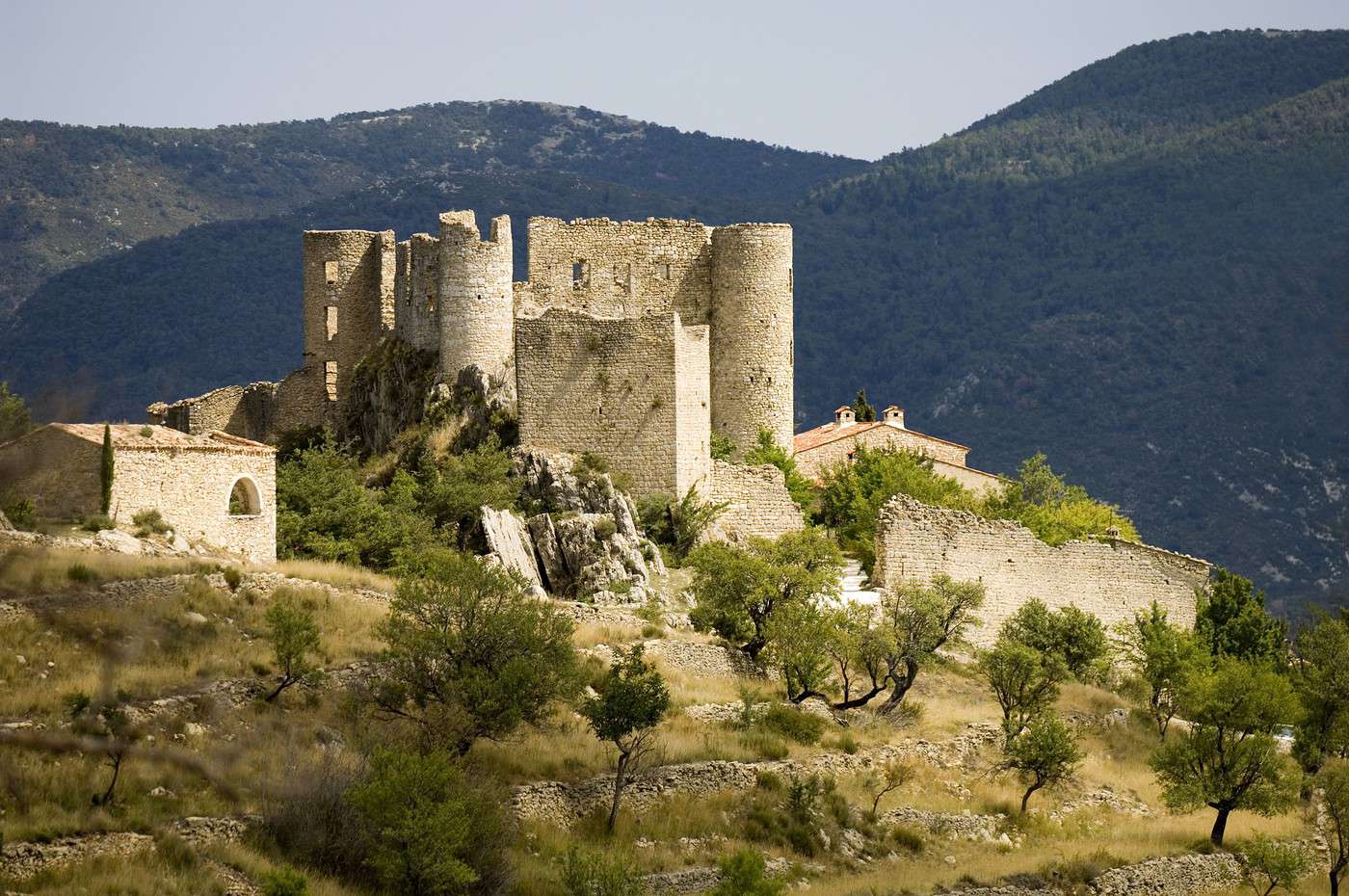
Bargème, Var, France
Bargème, Var, France · © VoyageForum

Key Facts

  • Type of place: department.
  • Tourist interest: (recommended).
  • Location:
  • Local time: Heure : Var
  • Department code: 83.
  • Bordering departments:
  • Sub-prefectures: Brignoles, Draguignan.
  • Number of municipalities: 153.
  • Population: 1,058,740 inhabitants (2017).
  • Area: 5,973 km².
  • Density: 174 inhabitants/km².
  • Highest point: Montagne de Lachens (1,715 m).
  • Lowest point: sea level.
  • Coastline: 420 km.
  • Highlights (out of ): Nature / ; Culture ; Relaxation-holidays

History of Var

Geography and Environment

Culture and Economy

What to See in Var

The sea, renowned seaside resorts (though some are overrated), charming small towns (Fayence, Tourtour, Gassin, etc.), and a hinterland perfect for walks—whether in the Maures Massif or the Esterel—make Var a complete holiday destination. Add to that two iconic natural sites, the Verdon and the Port-Cros National Park, and the choice becomes even more appealing. The only downside: overcrowding in certain areas or times of the year.

What to Do in Var

Climate and Weather

Var has a typical Mediterranean climate with abundant sunshine, dry and hot summers, and mild winters (slightly cooler in the northern part). It also experiences strong winds on the west coast and heavy, sometimes devastating autumn rains.

Sea Temperature Throughout the Year

Jan.Feb.Mar.Apr.MayJun.Jul.Aug.Sep.Oct.Nov.Dec.
Var131213141620222322191614

Transport

Getting There

Getting Around

Accommodation

Food

Additional Information

Saint-Raphaël

This seaside resort, which enjoyed its heyday in the 19th century as evidenced by some of its period buildings, is part of the Fréjus urban area. Water-based activities, from boating to small sea cruises, are well developed here.

Overview of Saint-Raphaël

This seaside resort, which enjoyed its heyday in the 19th century as evidenced by some of its period buildings, is part of the Fréjus urban area. Water-based activities, from boating to small sea cruises, are well developed here.

Key Facts

  • Type of place: small town.
  • Tourist interest: (worth seeing).
  • Location:
  • Distances:
  • Local time: Heure : 8462.
  • Population: 34,567 inhabitants (2014).
  • Area: 89.59 km².
  • Altitude: sea level.

History of Saint-Raphaël

What to See and Do in Saint-Raphaël

In the Surrounding Area

Climate and Weather in Saint-Raphaël

The town has a typically Mediterranean climate, very sunny, with mild winters and hot, dry summers. Rainfall occurs in autumn, particularly around October-November. The wind is often present and can sometimes blow in gusts.

Sea Temperature Throughout the Year

Jan.Feb.Mar.Apr.MayJun.Jul.Aug.Sep.Oct.Nov.Dec.
Saint-Raphaël131213141620222322191614

Transportation

Getting There

Getting Around

Accommodation

Dining

Useful Addresses

Additional Information

View guide page: Saint-Raphaël

Thoronet Abbey

This is a beautiful Cistercian abbey not far from the town of Draguignan.

Overview of the abbey

This is a beautiful Cistercian abbey not far from the town of Draguignan.

  • Tourist interest: (worth a stop if you are in the area).

History of the abbey

What to see and do

Practical information

  • Location:
  • Address: 83340 Le Thoronet.
  • Opening hours:
  • Price:
  • How to get there:

What to see nearby

  1. == In addition
View guide page: Thoronet Abbey

Bandol

Between La Ciotat and Toulon, Bandol is a marina and seaside resort particularly popular for diving.

Overview of Bandol

Between La Ciotat and Toulon, Bandol is a marina and seaside resort particularly popular for diving.

Key facts

  • Type of place: small town.
  • Tourist interest: (worth a stop if you are in the area).
  • Location:
  • Distances:
  • Local time: Heure : 18193.
  • Population: 7,878 inhabitants (2014).
  • Area: 8.58 km².
  • Altitude: sea level.

History of Bandol

What to see and do in Bandol

In the surrounding area

Climate and weather in Bandol

The local climate is typically Mediterranean, with plenty of sunshine, mild winters, and hot, dry summers. Rainfall occurs mainly in autumn, particularly around October-November. The wind is fairly common and can sometimes blow in gusts.

Sea temperature throughout the year

Jan.Feb.Mar.Apr.MayJun.Jul.Aug.Sep.Oct.Nov.Dec.
Bandol131213141620222322191614

Transport

Getting there

Getting around

Accommodation

Food

Useful addresses

Further information

View guide page: Bandol

Bargème

This 12th-century medieval village at the foot of its castle offers a stunning panorama of the surrounding area. It is the highest commune in the department at an altitude of 1,000 m.

Overview of Bargème

This 12th-century medieval village at the foot of its castle offers a stunning panorama of the surrounding area. It is the highest commune in the department at an altitude of 1,000 m.

Key Facts

  • Type of place: village.
  • Tourist interest: (worth seeing).
  • Location:
  • Distances:
  • Local time: Heure : 18194.
  • Population: 185 inhabitants (2014).
  • Area: 27.95 km².
  • Altitude: from 824 to 1,589 m.

History of Bargème

What to See and Do in Bargème

In the Surrounding Area

Climate and Weather in Bargème

Transportation

Getting There

Getting Around

Where to Stay

Where to Eat

Useful Addresses

Further Information

View guide page: Bargème

Bormes-les-Mimosas

Originally an old seaside village with its surrounding beaches and marina.

Overview of Bormes-les-Mimosas

Originally an old seaside village with its surrounding beaches and marina.

Key details

  • Type of place: small town.
  • Tourist interest: (worth seeing).
  • Location:
  • Distances:
  • Local time: Heure : 18195.
  • Population: 7,839 inhabitants (2014).
  • Area: 97.3 km².
  • Altitude: from 0 to 642 m.
  • Website:

History of Bormes-les-Mimosas

What to see and do in Bormes-les-Mimosas

Nearby

Climate and weather

The town has a typically Mediterranean climate, very sunny, with mild winters and hot, dry summers. Rainfall occurs in autumn, particularly around October-November. As for the wind, it is quite common and can sometimes blow in gusts.

Transport

Getting there

Getting around

Accommodation

Food

Useful addresses

Further information

View guide page: Bormes-les-Mimosas

Cavalaire

The seaside resort near Saint-Tropez boasts the longest sandy beach on the coast.

Overview of Cavalaire

The seaside resort near Saint-Tropez has the longest sandy beach on the coast.

Key Facts

  • Type of place: small town.
  • Tourist interest: (worth a stop if you are in the area).
  • Location:
  • Distances:
  • Local time: Heure : 18196.
  • Population: 7,166 inhabitants (2014).
  • Area: 16.74 km².
  • Altitude: from 0 to 528 m.

History of Cavalaire

What to See and Do in Cavalaire

In the Surrounding Area

Climate and Weather in Cavalaire

The town has a typically Mediterranean climate, with plenty of sunshine, mild winters, and hot, dry summers. Rainfall occurs mainly in autumn, particularly in October and November. The wind is often present and can sometimes blow in gusts.

Sea Temperature Throughout the Year

Jan.Feb.Mar.Apr.MayJun.Jul.Aug.Sep.Oct.Nov.Dec.
Cavalaire131213141620222322191614

Transport

Getting There

Getting Around

Accommodation

Dining

Useful Addresses

Further Information

View guide page: Cavalaire

Cogolin

This small town stretching from the Massif des Maures to the sea has an old centre.

Overview of Cogolin

This small town stretching from Maures Massif to the sea has an old centre.

Key facts

  • Type of place: small town.
  • Tourist interest: (worth a stop if you are in the area).
  • Location:
  • Distances:
  • Local time: Heure : 18197.
  • Population: 12,517 inhabitants (2014).
  • Area: 27.93 km².
  • Altitude: from 0 to 390 m.

History of Cogolin

What to see and do in Cogolin

In the surrounding area

Climate and weather in Cogolin

The town has a typically Mediterranean climate, very sunny, with mild winters and hot, dry summers. Rainfall occurs in autumn, particularly around October-November. As for the wind, it is quite present and can sometimes blow in gusts.

Transport

Getting there

Getting around

Accommodation

Food

Useful addresses

Further information

View guide page: Cogolin

Draguignan

It was the former prefecture of the Var department until 1974. The city is not very touristy.

Overview of Draguignan

It was the former prefecture of the Var department until 1974. The city is not very touristy.

Key Facts

  • Type of place: small town.
  • Tourist interest: (worth a stop if you are in the area).
  • Location:
  • Distances:
  • Local time: Heure : 18198.
  • Population: 40,054 inhabitants (2014).
  • Area: 53.7 km².
  • Altitude: from 153 to 603 m.

History of Draguignan

What to see and do in Draguignan

In the surrounding area

Climate and weather in Draguignan

Transportation

Getting there

Getting around

Where to stay

Where to eat

Useful addresses

Further information

View guide page: Draguignan

Fayence

Between sea and mountains, Fayence is a charming hilltop town known for its narrow streets and historic houses.

Overview of Fayence

Between sea and mountains, Fayence is a charming hilltop town known for its narrow streets and historic houses.

Key Facts

  • Type of place: small town.
  • Tourist interest: (worth seeing).
  • Location:
  • Distances:
  • Local time: Heure : 18199.
  • Population: 5,602 inhabitants (2014).
  • Area: 27.68 km².
  • Altitude: from 184 to 665 m.

History of Fayence

What to See and Do in Fayence

In the Surrounding Area

Climate and Weather in Fayence

Transportation

Getting There

Getting Around

Accommodation

Dining

Useful Addresses

Additional Information

View guide page: Fayence

Fréjus

Paired with Saint-Raphaël as part of the same urban area, Fréjus boasts various remnants of its Roman and medieval past, as well as several architectural landmarks (villas and others) from the 19th century.

Overview of Fréjus

Paired with Saint-Raphaël as part of the same urban area, Fréjus boasts various remnants of its Roman and medieval past, as well as several architectural landmarks (villas and others) from the 19th century.

Key facts

  • Type of place: city.
  • Tourist interest: (worth a stop if you are in the area).
  • Location:
  • Distances:
  • Local time: Heure : 18200.
  • Population: 53,511 inhabitants (2014).
  • Area: 102.27 km².
  • Altitude: sea level.

History of Fréjus

What to see and do in Fréjus

Nearby

Climate and weather in Fréjus

The city enjoys a typically Mediterranean climate, with plenty of sunshine, mild winters, and hot, dry summers. Rainfall occurs mainly in autumn, particularly in October and November. The wind is also quite common and can sometimes blow in strong gusts.

Transport

Getting there

Getting around

Accommodation

Eating out

Useful addresses

Further information

View guide page: Fréjus

Gassin

Perched above the Gulf of Saint-Tropez, Gassin is one of the "most beautiful villages in France" thanks to its picturesque architecture.

Overview of Gassin

Perched above the Gulf of Saint-Tropez, Gassin is one of the "most beautiful villages in France" thanks to its picturesque architecture.

Key facts

  • Type of place: small town.
  • Tourist interest: (worth seeing).
  • Location:
  • Distances:
  • Local time: Heure : 18201.
  • Population: 2,658 inhabitants (2014).
  • Area: 24.74 km².
  • Altitude: sea level.

History of Gassin

What to see and do in Gassin

In the surrounding area

Climate and weather in Gassin

The town enjoys a typically Mediterranean climate, with plenty of sunshine, mild winters, and hot, dry summers. Rainfall occurs mainly in autumn, particularly around October-November. The wind is also a common feature and can sometimes blow in strong gusts.

Getting around

How to get there

Getting around

Where to stay

Where to eat

Useful addresses

Further information

View guide page: Gassin

Grimaud

A medieval old village at the foot of its castle and a lakeside city (Port Grimaud) designed by a renowned architect in the 1960s. The two "styles" make the town quite popular with visitors.

Overview of Grimaud

It’s both a medieval old village at the foot of its castle and a lakeside city (Port Grimaud) designed by a renowned architect in the 1960s. The two "styles" make the town quite popular with visitors.

Key facts

  • Type of place: small town.
  • Tourist interest: (worth seeing).
  • Location:
  • Distances:
  • Local time: Heure : 18202.
  • Population: 4,065 inhabitants (2014).
  • Area: 44.58 km².
  • Altitude: from 0 to 503 m.

History of Grimaud

What to see and do in Grimaud

In the surrounding area

Climate and weather in Grimaud

The town enjoys a Mediterranean climate with hot, dry summers and mild, wet winters. It has one of the highest levels of sunshine in France, and rainfall is fairly low (especially in summer) and mostly confined to the end of the year.

Transport

Getting there

Getting around

Accommodation

Eating out

Useful addresses

Further information

View guide page: Grimaud

Hyères

A seaside resort near Toulon with some beautiful early 20th-century mansions and several thousand palm trees. Sandy beaches and rocky coves surround the area, mainly on the Giens peninsula, which is part of the municipality.

Overview of Hyères

It’s a seaside resort near Toulon with some beautiful early 20th-century mansions and several thousand palm trees. All around are sandy beaches and rocky coves, mainly on the Giens peninsula, which is part of the municipality.

Key facts

  • Type of place: city.
  • Tourist interest: (worth seeing).
  • Location:
  • Distances:
  • Local time: Heure : 18203.
  • Population: 56,502 inhabitants (2014).
  • Area: 132.28 km².
  • Altitude: sea level.

History of Hyères

What to see and do in Hyères

In the surrounding area

Climate and weather in Hyères

The town has a typically Mediterranean climate, with plenty of sunshine, mild winters, and hot, dry summers. Rainfall occurs mainly in autumn, particularly in October and November. The wind is also a common feature and can sometimes blow in strong gusts.

Sea temperature throughout the year

Jan.Feb.Mar.Apr.MayJun.Jul.Aug.Sep.Oct.Nov.Dec.
Hyères131213141620222322191614

Transport

Getting there

Getting around

Accommodation

Eating out

Useful addresses

Further information

View guide page: Hyères

Porquerolles Island

Opposite Hyères, it’s a major tourist hotspot in the region. Visitors come for its landscapes, beaches, diving, and hiking.

Overview of Porquerolles

Opposite Hyères, this island—part of the three Hyères islands (along with Port Cros and Bagaud)—is a major tourist hotspot in the region. Visitors come for its landscapes, beaches, diving, and hiking.

Key facts

  • Tourist interest: (must-see or highly recommended).
  • Location:
  • Local time: Heure : 18204
  • Main locality:
  • Population:
  • Area: 12.54 km².
  • Highest point: 142 m.
  • Coastline: 30 km.

History of Porquerolles Island

Environment

Wildlife and flora

Precautions

What to see and do

In the area

Climate and weather in Porquerolles

Transport

Getting there

Getting around

Accommodation

Eating

Useful addresses

Further information

View guide page: Porquerolles Island

La Croix Valmer

A seaside resort with beautiful beaches near Saint-Tropez.

Overview of La Croix Valmer

A seaside resort with beautiful beaches near Saint-Tropez.

Key Information

  • Type of place: small town.
  • Tourist interest: (worth seeing).
  • Location:
  • Distances:
  • Local time: Heure : 18205.
  • Population: 3,711 inhabitants (2014).
  • Area: 22.28 km².
  • Altitude: from 0 to 369 m.

History of La Croix Valmer

What to See and Do

In the Surrounding Area

Climate and Weather

The town has a typically Mediterranean climate, very sunny, with mild winters and hot, dry summers. Rainfall occurs in autumn, particularly in October-November. The wind is often present and can sometimes blow in gusts.

Sea Temperature Throughout the Year

Jan.Feb.Mar.Apr.MayJun.Jul.Aug.Sep.Oct.Nov.Dec.
La Croix Valmer131213141620222322191614

Transportation

Getting There

Getting Around

Accommodation

Dining

Useful Addresses

Additional Information

View guide page: La Croix Valmer

La Londe-les-Maures

It’s both a seaside resort and a marina between Hyères and Le Lavandou.

Overview of La Londe-les-Maures

It’s both a seaside resort and a marina between Hyères and Le Lavandou.

Key facts

  • Type de lieu: small town.
  • Intérêt touristique: (worth a stop if you are in the area).
  • Localisation:
  • Distances:
  • Heure locale: Heure : 18206.
  • Population: 8,234 inhabitants (2014).
  • Superficie: 79.29 km².
  • Altitude: from 0 to 601 m.

History of La Londe-les-Maures

What to see and do

In the surrounding area

Climate and weather

The town has a typically Mediterranean climate, very sunny, with mild winters and hot, dry summers. Rainfall occurs mainly in autumn, particularly around October-November. The wind is often present and can sometimes blow in gusts.

Sea temperature throughout the year

Jan.Feb.Mar.Apr.MayJun.Jul.Aug.Sep.Oct.Nov.Dec.
La Londe131213141620222322191614

Getting around

How to get there

Getting around

Where to stay

Where to eat

Useful addresses

Further information

View guide page: La Londe-les-Maures

La Seyne-sur-Mer

This large city in the Toulon roadstead, once specialized in naval shipyards, has reinvented itself as a seaside resort. It also features several old fortified structures built to protect the bay.

Overview of La Seyne-sur-Mer

This large city in Toulon Harbour was once specialized in naval shipyards and has since transformed into a seaside resort and occasionally a stopover for cruise ships. Several old fortified structures built to protect the bay can also be seen here.

Key details

  • Type of place: city.
  • Tourist interest: (worth a stop if you are in the area).
  • Location:
  • Distances:
  • Local time: Heure : 18207.
  • Population: 64,675 inhabitants (2014).
  • Area: 22.17 km².
  • Altitude: 0 to 352 m.

History of La Seyne-sur-Mer

What to see and do

In the surrounding area

Climate and weather

The town has a typically Mediterranean climate, with plenty of sunshine, mild winters, and hot, dry summers. Rainfall occurs mainly in autumn, particularly in October and November. The wind is also quite common and can sometimes blow in strong gusts.

Sea temperature throughout the year

Jan.Feb.Mar.Apr.MayJun.Jul.Aug.Sep.Oct.Nov.Dec.
La Seyne131213141620222322191614

Transport

Getting there

Getting around

Accommodation

Food

Useful addresses

Further information

View guide page: La Seyne-sur-Mer

Castellet

Built around a castle, this is a charming fortified medieval village northwest of Toulon.

Overview of Castellet

Built around a castle, this is a charming fortified medieval village northwest of Toulon.

Key Facts

  • Type of place: small town.
  • Tourist interest: (worth seeing).
  • Location:
  • Distances:
  • Local time: Heure : 18208.
  • Population: 4,019 inhabitants (2014).
  • Area: 44.77 km².
  • Altitude: from 21 to 503 m.

History of Castellet

What to See and Do in Castellet

In the Surrounding Area

Climate and Weather in Castellet

Transportation

Getting There

Getting Around

Accommodation

Dining

Useful Addresses

Further Information

View guide page: Castellet

Le Lavandou

Facing the sea and at the foot of the Massif des Maures, Le Lavandou is a chic marina, seaside resort, and holiday destination. Scuba diving is available here.

Overview of Le Lavandou

Facing the sea and at the foot of the Maures Massif, Le Lavandou is a marina, a seaside resort, and one of the chicest holiday destinations. Scuba diving is available here.

Key Facts

  • Type of place: small town.
  • Tourist interest: (worth a stop if you are in the area).
  • Location:
  • Distances:
  • Local time: Heure : 18209.
  • Population: 5,246 inhabitants (2014).
  • Area: 29.65 km².
  • Altitude: from 0 to 485 m.

History of Le Lavandou

What to See and Do in Le Lavandou

In the Surrounding Area

Climate and Weather in Le Lavandou

The town has a typically Mediterranean climate, with plenty of sunshine, mild winters, and hot, dry summers. Rainfall occurs mainly in autumn, particularly in October and November. The wind is often present and can sometimes blow in gusts.

Sea Temperature Throughout the Year

Jan.Feb.Mar.Apr.MayJun.Jul.Aug.Sep.Oct.Nov.Dec.
Le Lavandou131213141620222322191614

Transportation

Getting There

Getting Around

Accommodation

Dining

Useful Addresses

Further Information

View guide page: Le Lavandou

Mons (83)

This old hilltop village offers a superb panorama of the surrounding area. You can see pretty stone houses along narrow lanes.

Overview of Mons

This old hilltop village offers a superb panorama of the surrounding area. You can see pretty stone houses along narrow lanes.

Key details

  • Type of place: village.
  • Tourist interest: (worth a stop if you are in the area).
  • Location:
  • Distances:
  • Local time: Heure : 18210.
  • Population: 871 inhabitants (2014).
  • Area: 76.63 km².
  • Altitude: from 235 to 1,714 m.

History of Mons

What to see and do in Mons

In the surrounding area

Climate and weather in Mons

Transport

Getting there

Getting around

Accommodation

Food

Useful addresses

  1. == Additional information
View guide page: Mons (83)

Ramatuelle

Built on a hillside, the village overlooks the bay of Saint-Tropez. The famous Pampelonne beach is located within its boundaries.

Overview of Ramatuelle

Built on a hillside, the village overlooks the bay of Saint-Tropez. The famous Pampelonne beach is located within its boundaries.

Key Facts

  • Type of place: village.
  • Tourist interest: (worth a stop if you are in the area).
  • Location:
  • Distances:
  • Local time: Heure : 18211.
  • Population: 2,111 inhabitants (2014).
  • Area: 35.57 km².
  • Altitude: from 0 to 147 m.

History of Ramatuelle

What to See and Do in Ramatuelle

In the Surrounding Area

Climate and Weather in Ramatuelle

The town enjoys a Mediterranean climate with hot, dry summers and mild, wet winters. It has one of the highest levels of sunshine in France, and rainfall is relatively low (especially in summer), limited mainly to the end of the year.

Sea Temperature Throughout the Year

Jan.Feb.Mar.Apr.MayJun.Jul.Aug.Sep.Oct.Nov.Dec.
Ramatuelle131213141620222322191614

Transportation

Getting There

Getting Around

Accommodation

Dining

Useful Addresses

Further Information

View guide page: Ramatuelle

Roquebrune-sur-Argens

It's an old village located in the hinterland of Fréjus but also extends to the sea.

Overview of Roquebrune-sur-Argens

It's an old village located in the hinterland of Fréjus but also extends to the sea.

Key Facts

  • Type of place: small town.
  • Tourist interest: (worth a stop if you are in the area).
  • Location:
  • Distances:
  • Local time: Heure : 18212.
  • Population: 12,344 inhabitants (2014)
  • Area: 106.10 km².
  • Altitude: from 0 to 482 m.

History of Roquebrune-sur-Argens

What to See and Do

In the Surrounding Area

Climate and Weather

Transport

Getting There

Getting Around

Accommodation

Food

Useful Addresses

Additional Information

View guide page: Roquebrune-sur-Argens

Saint-Cyr-sur-Mer

A small marina with its beach, nestled in a bay surrounded by pine forests and vineyards.

Overview of Saint-Cyr-sur-Mer

A small marina with its beach, nestled in a bay surrounded by pine forests and vineyards.

Key facts

  • Type of place: small town.
  • Tourist interest: (worth seeing).
  • Location:
  • Distances:
  • Local time: Heure : 18213.
  • Population: 12,262 inhabitants (2014).
  • Area: 21.15 km².
  • Altitude: from 0 to 254 m.

History of Saint-Cyr-sur-Mer

What to see and do

In the surrounding area

Climate and weather

The town has a typically Mediterranean climate, with plenty of sunshine, mild winters, and hot, dry summers. Rainfall occurs mainly in autumn, particularly in October and November. The wind is often present and can sometimes blow in gusts.

Sea temperature throughout the year

Jan.Feb.Mar.Apr.MayJun.Jul.Aug.Sep.Oct.Nov.Dec.
Saint-Cyr131213141620222322191614

Transport

Getting there

Getting around

Accommodation

Food

Useful addresses

Further information

View guide page: Saint-Cyr-sur-Mer

Saint-Maximin-la-Sainte-Baume

At the foot of the Sainte-Baume massif, the town boasts a beautiful basilica and historic quarters.

Overview of Saint-Maximin

At the foot of Sainte-Baume Massif, the town boasts a beautiful basilica and historic quarters.

Key Facts

  • Type of place: small town.
  • Tourist interest: (worth a stop if you are in the area).
  • Location:
  • Distances:
  • Local time: Heure : 18214.
  • Population: 15,753 inhabitants (2014)
  • Area: 64.8 km².
  • Altitude: from 264 to 773 m.

History of Saint-Maximin

What to See and Do

In the Surrounding Area

Climate and Weather

Transport

Getting There

Getting Around

Accommodation

Dining

Useful Addresses

Further Information

View guide page: Saint-Maximin-la-Sainte-Baume

Saint-Tropez

Internationally renowned as a legendary, upscale, and trendy seaside resort, Saint-Trop will delight fans of the genre, even if its fame (from the 1950s–70s) is starting to feel a bit dated. Internationally renowned as a legendary, upscale, and trendy seaside…

Read the full guide: Saint-Tropez

Sainte-Maxime

A well-known seaside resort between Fréjus and Saint-Tropez.

Overview of Sainte-Maxime

A well-known seaside resort between Fréjus and Saint-Tropez.

Key facts

  • Type of place: small town.
  • Tourist interest: (worth a stop if you are in the area).
  • Location:
  • Distances:
  • Local time: Heure : 18216.
  • Population: 14,018 inhabitants (2014).
  • Area: 81.61 km².
  • Altitude: from 0 to 522 m.

History of Sainte-Maxime

What to see and do in Sainte-Maxime

In the surrounding area

Climate and weather in Sainte-Maxime

The town enjoys a Mediterranean climate with hot, dry summers and mild, wet winters. It has one of the highest levels of sunshine in France, and rainfall is relatively low (especially in summer), mostly occurring at the end of the year.

Sea temperature throughout the year

Jan.Feb.Mar.Apr.MayJun.Jul.Aug.Sep.Oct.Nov.Dec.
Sainte-Maxime131213141620222322191614

Transport

Getting there

Getting around

Accommodation

Food

Useful addresses

Further information

View guide page: Sainte-Maxime

Sanary-sur-Mer

It’s a charming little fishing port near Toulon and Marseille.

Overview of Sanary-sur-Mer

It’s a charming little fishing port near Toulon.

Key facts

  • Type of place: small town.
  • Tourist interest: (worth seeing).
  • Location:
  • Distances:
  • Local time: Heure : 18217.
  • Population: 16,733 inhabitants (2016).
  • Area: 19.24 km².
  • Altitude: from 0 to 429 m.

History of Sanary-sur-Mer

What to see and do in Sanary

In the surrounding area

Climate and weather in Sanary

The town has a typically Mediterranean climate, with plenty of sunshine, mild winters, and hot, dry summers. Rainfall occurs mainly in autumn, particularly around October–November. The wind is also a common feature and can sometimes blow in strong gusts.

Sea temperature throughout the year

Jan.Feb.Mar.Apr.MayJun.Jul.Aug.Sep.Oct.Nov.Dec.
Sanary131213141620222322191614

Transport

Getting there

Getting around

Accommodation

Food

Useful addresses

Further information

View guide page: Sanary-sur-Mer

Seillans

A beautiful fortified medieval village located in the northern part of the Var department.

Overview of Seillans

A beautiful fortified medieval village located in the northern part of the Var department.

Key Details

  • Type of place: small town.
  • Tourist interest: (worth seeing).
  • Location:
  • Distances:
  • Local time: Heure : 18218.
  • Population: 2,540 inhabitants (2014).
  • Area: 88.66 km².
  • Altitude: from 137 to 1,303 m.

History of Seillans

What to See and Do in Seillans

In the Surrounding Area

Climate and Weather in Seillans

Transportation

Getting There

Getting Around

Accommodation

Dining

Useful Addresses

Additional Information

View guide page: Seillans

Six-Fours-les-Plages

A seaside resort between Sanary and La Seyne, on the doorstep of Toulon.

Overview of Six-Fours

It’s a seaside resort between Sanary and La Seyne, on the doorstep of Toulon.

Key facts

  • Type of place: small town.
  • Tourist interest: (worth a stop if you are in the area).
  • Location:
  • Distances:
  • Local time: Heure : 18219.
  • Population: 33,652 inhabitants (2014).
  • Area: 26.58 km².
  • Altitude: sea level.

History of Six-Fours-les-Plages

What to see and do in Six-Fours

In the surrounding area

Climate and weather in Six-Fours

The town has a typically Mediterranean climate, very sunny, with mild winters and hot, dry summers. Rainfall occurs in autumn, particularly around October–November. The wind is quite common and can sometimes blow in gusts.

Sea temperature throughout the year

Jan.Feb.Mar.Apr.MayJun.Jul.Aug.Sep.Oct.Nov.Dec.
Six-Fours131213141620222322191614

Transport

Getting there

Getting around

Accommodation

Eating

Useful addresses

Further information

View guide page: Six-Fours-les-Plages

Toulon

It is the capital of the Var department. In addition to its port opening onto its bay, Toulon offers visitors some old quarters and beaches on its outskirts. Overview of Toulon Toulon Climate and Weather What to see in Toulon Things to Do in Toulon Flying to Toulon Getting to Toulon by Land or Sea Getting Around Toulon Accommodation and Dining in Toulon Living in Toulon

Further Information

View guide page: Toulon

Overview of Toulon

Overview of Toulon

It is the capital of the Var department. In addition to its port opening onto its bay, Toulon offers visitors some old quarters and beaches on its outskirts.

Key Facts

  • Type of place: large city.
  • Tourist interest: (worth a stop if you are in the area).
  • Location:
  • Distances:
  • Local time: Heure : 18220.
  • Population: 171,953 inhabitants and approximately 610,000 for the metropolitan area (2017).
  • Area: 42.84 km².
  • Altitude: from sea level to 584 m.

History of Toulon

Useful Addresses

  • Tourist Office:

Services

  • Local agencies:
  • Banks:
  • Hospital:
  • Internet:
  • Laundromats:
  • Vehicle rental:
  • Post office:
View guide page: Overview of Toulon

Toulon Climate and Weather

Climate Overview

The city has a typically Mediterranean climate, very sunny, with mild winters and hot, dry summers. Rainfall occurs in autumn, particularly around October-November. As for the wind, it is quite common and can sometimes blow in gusts.

Best Time to Visit Toulon Weather-Wise

Jan.Feb.Mar.Apr.MayJun.Jul.Aug.Sep.Oct.Nov.Dec.
Climate

Sea Temperature Throughout the Year

Jan.Feb.Mar.Apr.MayJun.Jul.Aug.Sep.Oct.Nov.Dec.
Toulon131213141620222322191614

Climate and Forecast

Additional Information

View guide page: Toulon Climate and Weather

What to see in Toulon

Toulon Opera House ★ It is the largest opera theatre in the provinces. Built in the 1860s, it is a fine example of neoclassical architecture. Puget Square ★ The heart of the city and Toulon's former main square. It is known for its shaded terraces and the…

Read the full guide: What to see in Toulon

Flying to Toulon

Toulon Airport

Airport details

  • Name: Toulon-Hyères Airport.
  • IATA code: TLN
  • Hub: no.
  • Number of terminals: 1.
  • Annual passenger capacity:
  • Passenger traffic: 570,140 (2018).
  • Distance from city centre: 19 km east of Toulon (and 3 km southeast of Hyères).

Services

Sleeping at the airport

Transport to the city centre

Other nearby airports

From the rest of the country

From elsewhere

Additional information

View guide page: Flying to Toulon

Tourtour

It is one of the "most beautiful villages in France" for its typical Provençal charm.

Overview of Tourtour

It is one of the "most beautiful villages in France" for its typical Provençal charm.

Key Facts

  • Type of place: village.
  • Tourist interest: (worth seeing).
  • Location:
  • Distances:
  • Local time: Heure : 18221.
  • Population: 589 inhabitants (2014).
  • Area: 28.69 km².
  • Altitude: from 375 to 904 m.

History of Tourtour

What to see and do in Tourtour

In the surrounding area

Climate and weather in Tourtour

Transport

Getting there

Getting around

Accommodation

Eating

Useful addresses

Further information

View guide page: Tourtour

Maures Massif

Between Hyères and Fréjus, a small mountain range opening onto the coast.

Overview of the Maures Massif

Between Hyères and Fréjus, it is a small mountain range opening onto the coast.

Key Points

  • Tourist interest: (worth a stop if you are in the area).
  • Characteristics:
  • Massif:
  • Area:
  • Summit: Signal de la Sauvette (780 m).

Environment

Wildlife and flora

Population and economic activity

Precautions

Climate and weather

What to see and do

Practical information

  • Location:
  • Distances:
  • Website:

Getting there

Getting around

Accommodation and dining

What to see nearby

Additional information

View guide page: Maures Massif

Port-Cros National Park

The site covers the entire island of the same name (and part of Porquerolles) off the coast of Hyères. Visitors come for diving, boat trips, hiking, and, incidentally, these old forts.

Overview of the park

The site covers the entire island of the same name (and part of Porquerolles) off the coast of Hyères. Visitors come for diving, boat trips, hiking, and, incidentally, these old forts.

Key facts

  • Tourist interest: (worth seeing).
  • Features:
  • Area: 7 km² (land) and 13 km² (marine).
  • Altitude: sea level.

Environment

Wildlife and flora

Precautions

Climate and weather

What to see and do

Practical information

  • Location:
  • Opening period:
  • How to get there:
  • Distances:

Sleeping and eating

Nearby attractions

Additional information

View guide page: Port-Cros National Park

Something wrong or out of date? Report this page