Salut!
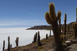
Nous envisageons de faire le trek du canyon de colca en mai.
Est ce qu'il existe des cartes IGN (ou équivalent) et comment s'en proccurer?
Est-ce que le sentier est balisé? ET niveau difficulté? Quels sont les dénivelés?
Est- il possible d'acheter à manger sur l'itinéraire?
Conseillez-vous de prendre un guide, ou un sherpa?
Voilà, un peu toutes les questions qu'on se pose!!
salut
pas besoin de guide dans le colca, pas de carte ign, mais des croquis, je scanne ca et je te l'envoie quand je peux
pas de denivele important et pas de probleme d'altitude, ca ne fait que 3000m!
auberges aux arrets pas cher
a+
J'ai fait le trek Cabanaconde = Choco = Mina = Chachas, puis minibus sur Andagua. Varié, peu de touristes, physique (col à 5000 m). 4 jours pour moi. Avec la description et la carte du guide LP 'Trekking in the Central Andes', cela suffit largement.
salut
ouf !je viens de t'envoyer l'autre plan
Ah les mysteres de l'informatique!!
j'ai fais le misti, le colca, l'ausangate(sur 4 j) et le choquequirao(sur 3)plus 2 petites rando sur taquile et amantani et 1 journée sur maras et moray
ce que j'ai preferé?Tout..
A faire, mais une chose est sure, c'est que faut etre un peu barge et je ne pense pas que je le referais
nous faisons le nord cette année avec l'amazonie, et le ferons surement pour trnaquillement, quoique?avec les barges...
a+
Il y a de nombreux treks au Pérou dans ce guide, mais uniquement celui-là pour le canyon de Colca, je crois. Donc, si tu veux simplement descendre au fond du canyon, cela ne sera pas inclus.
Salut
Je pars au Pérou avec mon copain en juillet 2006 et nous projetons aussi de faire le treck du canyon de colca
Combien de jour cela vous a pris? et où aves vous dormi ? dans les auberges ? est-il posible de camper?
Je suis également intéressée par le carte dont tu parles Si ca ne te dérange pas de me l'envoyer mon adresse: marionrubert@yahoo.fr
Merci d'avance
le sujet est abordé dans plusieurs discussions, fais une recheche sur le site.
Pour commencer il y a celle-ci:
http://voyageforum.com/v.f?post=278084;search_string=canon%20de%20colca;#278084
Un guide n'est pas obligatoire, il n'y a pas beaucoup de chemins et tu peux toujours demander ta route (si on ne t'a pas déjà rattrapé pour te dire que c'est l'autre chemin!)
Bonjour,
je suis toute nouvelle sur ce forum.
Je pars au Pérou dans 2 semaines, et ce forum m'a bien aidée à faire mon programme.
Je souhaiterais moi aussi faire le Canyon del Colca : est ce que Micmag, tu peux m'envoyer la carte qui ne passe que par mail (désolée, je sais que plusieurs te l'ont déjà demandée). Mon mail, c'est pouquie2@hotmail.com
Et j'aimerais aussi poser une question : avant de faire le Canyon, je serais à Puno : est ce que quelqu'un sait si je peux aller direct à Cabanaconde de Puno (en bus) ou bien si je suis obligée de faire une étape à Arequipa ? Ca me gagnerais, je pense, une journée. Mais je ne trouve rien dans le Lonely Planet ...
salut clarisse
je ne pense pas que tu puisse faire Puno, cabanaconde direct à mos avis tu dois repasser par arequipa
je suis en train de mettre mes plans et cartes, ainsi que mes itineraires sur blog
apparement j'ai des difficultés à faire passer les cartes sur le forum
a+, si tu as besoin et bon voyage
Merci beaucoup pour ta réponse très rapide : tant pis, je passerais par Arequipa avant d'aller à Cabanaconde !
Merci également pour les plans : je vais aller les chercher sur ton blog. Par contre, je viens d'essayer, mais l'adresse que tu m'a laissé ne marche pas, et je ne trouve pas ton blog quand je fais une recherche chez Expedia : es-tu en train de le terminer, auquel cas il n'est peut etre pas encore accessible ?
De toute manière, j'essaierais dans les prochains jours.
Salut!
Il faut prendre en bus depuis Arequipa vers Cabanaconde et Juste a coté de l’ancien hôtel valle del Fuego il y a un autre hotel de la même famille, jardin a coté de terraces, Salon principal avec toit de chaume, toutes les chambres avec toilettes privés et de l’eau très, très chaude. Toutes les chambres ont de fenêtres vers le jardin et avec une bonne vue aux montagnes. Dans cet hôtel Pablo ou JAmil peuvent te rensegner par rapport les treks. et ils te repaire pour trouver le debut de la descente au canyon.
important .- Les numéros de téléphones de cet hôtel dans les guides ne marche plus, le nouveaux numéro de téléphone est (054) 203737.
Pour les réservations en avance tu peux visiter le bureau de cet hôtel, adresse : Au centre ville d’Arequipa : Rue Jérusalem 400-AB-1 (hostal valle del Fuego).
Dans ce bureau on peut aussi acheter des cartes(1:100 00) pour le trekking du canyon du colca/ trekking cabanaconde/Andagua (la vallée de volcans). et aussi pour les treks dans le canyon de Cotahuasi
Réservations voie mail pour l'hotel: hvalledelfuego@hotmail.com
Et surement vous allez trouver dans ce bureau un de fils de Pablo qui parle très bien le français.
Dans ce bureau Il existe aussi la possibilité aussi de se renseigner pour les treks au fond du canyon (pour aller en solo) et aussi de partir dans de treks organisés au choix (a la carte).pour l’option trekking en solo sans guide il te donne (Edwing) incroyablement les infos pour y arriver et la seule chose à faire (réciprocité) …….. Est si tu dors a Cabanaconde choisir l’hôtel valle del Fuego ou si tu n’a pas le temps, manger quelques chose dans le restaurant valle del Fuego. (voila le troc).
ici quelques idees de treks au fond du canyon :
OPTION DE COLCA TREK NON CLASSIQUE
http://www.pablotour.com/fra/trek_aqp06.html
1°) tu réponds ici à une conversation qui date de... 2006 !!
Il y a donc près de 3 ans que ses participants sont déjà allé au Pérou et au Colca... un peu tard, non, pour leur donner ces infos ! 😉
2°) tu ne sembles t'être inscrit sur ce forum que pour faire de la publicité directe pour un seul hôtel bien précis (2 messages identiques en quelques minutes !!)... N'as-tu pas lu les conditions d'utilisation du forum ??? 😕
Il est interdit de poster des messages dans le Site dans le but de faire directement la promotion ou la publicité d’un service, produit, forfait ou site internet.
...
Il est interdit d'utiliser le Site, en public ou en privé, dans le but d'offrir, directement ou indirectement, un ou des services payants ou dans le but solliciter des clients potentiels.
...
Il est interdit de poster des messages identiques ou similaires dans un ou plusieurs rubriques du Site.
"Nous méritons toutes nos rencontres ; elles sont accordées à notre destin, et ont une signification qu'il nous appartient de déchiffrer." Mauriac
Bonjour,
Cela fait quelques années que tu as posté ce mail sur le site mais je voulais savoir s'i tu avais toujours ta carte pour faire le trek du canyon du colca seul, car nous y allons dans les jours qui suivent et nous souhaiterions le faire par nos propres moyens.
Mon adresse mail : boissel_florence@yahoo.fr
Je t'en remercie.
Flo
Je reviens du Cañon, je tenais à vous fais partager notre expérience puisque ce forum nous a bien aidé pour nous préparer :-)
Voici notre itinéraire :
- départ d'Arequipa à 6h30 en bus, direction Cabanaconde (conseil : réservez le bus la veille !). Arrivée à Cabanaconde vers 12h, repas au Valle del Fuego (sympa et bon, le type du resto peut vous indiquer le chemin pour commencer le trek). Départ du trek à 14h et arrivée à San Juan vers 18h, nuit chez Roy (sympa). Il y a plein d'hébergement dans tous les villages, donc pas de souci pour ça. Rien à voir par contre à San Juan, donc il vaut mieux faire le trek dans ce sens pour terminer par Llahuar.
- San Juan - Fure : grosse journée de marche (environ 7-8h avec les pauses), avec picnic frugal sur la route (pas de resto dans les villages traversés). Quelques frayeurs avant l'arrivée à Fure (chemin à moitié écroulé, vertige, nuit qui tombe et Fure invisible jusqu'au dernier moment...). Nuit au Descanso, le moins bien des hébergements, lits à la propreté limitée :-)
- le lendemain, on laisse tomber la cascade (qui est parait-il très belle) et on part directement vers Llahuar. Chemin très sympa et pas difficile, environ 4h de marche avec les pauses. Piscine chaude rien que pour nous et les moustiques, truite et nuit confortable.
- dernier jour, la montée vers Cabanaconde, longue mais pas trop difficile et spectaculaire. Arrêt au geyser, à ne pas manquer, on voit l'eau de la rivière bouillir, c'est vraiment impressionnant ! Il se trouve sur les cartes, au fond du cañon avant d'aborder la grande monde, à gauche avant le pont. Mais je crois que les fumées ne sont pas permanente, il faut avoir de la chance :-). Avant l'arrivée à Cabanaconde, la vue est magnifique, on a même aperçu un condor d'assez près. Nuit au Valle del Fuego.
- retour sur Arequipa avec un arrêt à la Cruz del Condor et aux piscines de Chivay.
En résumé, un superbe trek que je recommande, pas trop difficile, pas trop touristique (3 ou 4 touristes croisés en 4 jours), avec des curiosités (condors, geysers) et des parties "aventures" plutôt sympas (les ponts, les chemins escarpés, l'hébergement...). J'ai juste regretté l'aspect un peu trop mercantile des hébergements (7 soles tous les petit-déjeuners avec 2 pancakes et un maté de coca... mais c'est pas très grave) et le chemin parfois difficile à trouver (mais ça fait partie de l'aventure).
Je part en voyage avec mon amoureux au mois d'août. Nous aimerions faire la trek du Cayon de Colca. Voici nos questions: 1) Faire celle de 3 ou de 4 jours? 2)…
Aprés avoir lu quelques récits sur le trek du canyon.de Colca je me pose la question de la difficulté (avons prévu 3jours avec l'agence "pérou insolite".Nous…
Je n'ai pas assez de tps pour faire le trek de choquequirao et le trek du canyon de colca. lequel vaut le plus le coup? (sachant qu'avt j'aurais faist un trek…
Salus a tous. Je compte visiter la Colca au mois d’octobre. Pouvez me dire à quoi je dois m’attendre autre que la beauté des lieux. Puis je le faire sans…
Je prepare mon vyage pour le perou en novembre dc j essaie de faire au mieux vu que je ne connais pas du tout et que je pars seule alors je voulais faire un…
Bonjour,
Nous souhaitons faire le trek de 4 jours reliant Mestia à Ushguli sans agence. Il est précisé dans les descriptifs qu'il existe des hébergement à chaque étape, mais on ne trouve pas d'info sur ces hébergements. Quelqu'un a-t-il des infos et un avis sur ce parcours?
We're planning to trek in Peru and Bolivia and would love to find some local agencies.
If you know any, could you share details on prices and, of course, the names of the agencies?
Which trek would you recommend?
Elocine
Je pars en autonomie totale sur un trek au Maroc (10jrs) Imilchil - Aghbalou.
Trouve t-on des cartouches gaz à vis (Coleman, Primus) à Marrakech (adresse) ou villages entre Imilchil - Aghbalou ?
Si non , trouve-t-on des cartouches Butagaz pour camping-gaz (petit volume 230 gr ...)
Merci d' avance pour vos réponses
Hello, I’d like to embark on a little trip in my home country, Switzerland. I’ll start walking from La Cure, heading toward Le Noirmont first, then I’ll improvise my route—but it’ll probably follow the French border... at least as far as Lac de Joux.
I’ll decide day by day how much farther to go after that. My goal is to stay in nature as much as possible, wander around for as long as I can, and restock food in villages or towns along the way.
I’m thinking of mostly camping, but we’ll see if I end up in a hotel or another campsite depending on my route.
I’d love to reach La Chaux-de-Fonds on foot... maybe even Delémont.
The whole thing should take about a week, give or take.
I’ll be bringing my dog, and I’m preparing for this as soon as I’m ready.
Any tips to make sure everything goes smoothly for us? Things I should know—or avoid? What about shepherds with their flocks of sheep? And isn’t hunting season open right now?
I’m not sure if what I’m planning is even doable, which is why I’m asking around.
This’ll be my first time doing something like this—wandering in nature *and* with a dog. I’m really excited for this adventure... and I need it. Thanks!
We’re really keen on ecosystems and want to hike in "natural" ancient forests—not planted woods or areas heavily degraded by human activity. Travel guides (like Lonely Planet) don’t provide much info on this. Could you point us to the most interesting spots?
Thanks in advance for your tips.
We wish you happy holidays and a fantastic 2026, full of discoveries!
Claire and Albert
Hi, this might not be the right section, but I’d like to know if it’s possible to start mountaineering with another person without necessarily hiring a guide. We’ve done quite a bit of hiking but not mountaineering—we’ll just do a half-day glacier course. After that, we were thinking of starting with La Grande Motte and the Pointe de la Traversière, which were recommended to us. Honestly, for things like roping up and knots, I’ll learn at home with lots of videos and a book.
Hi,
I don’t know Switzerland at all and was wondering if Vallée des Joux and especially Dent de Vaulion are packed early in the morning or late in the afternoon in July and September?
If so, do you have any quieter spots to recommend in the area, or in Luxembourg (yes, I know it’s not the same country 😉)?
Thanks a lot!
I’m starting this thread—lots of travelers here have done this trek.
When RMS is mentioned, it’s this agency: Ruwenzori Mountaineering Services (with an *s*), because there’s another one online called Ruwenzori Mountaineering Service (no *s*).
Their site:
www.rwenzorimountaineeringservices.com/
From what I gather, it’s the local mountain guide agency certified by the government?
Jaimerais savoir si quelqu'un aurait fait des treks sur le Ruwenzori et combien ça coute en moyenne, les infrastructures, les paysages la sécurité sur les lieux, merci beaucoup. J'attends avec impatience vos réponses.
We’re leaving in 9 days for a two-week trip to Madeira, mainly to hike.
From my research, I’ve found that since last year, access to most trails—and systematically for the most popular ones—is now paid. You have to pay an access fee of 4.50 € per person per classified hike in 2026, and even 10.50 € for the most iconic hike: Pico Arieiro to Pico Ruivo. When paying, you also have to choose a day and a 30-minute time slot for your start time. Of course, this reservation is neither changeable nor refundable, even if the weather that day is terrible.
Personally, given the massive influx of tourists to the island in recent years, I don’t mind paying a fee to help maintain the trails. Similarly, setting a limit on the number of people who can hike them per day is certainly preferable to preserve this priceless heritage.
However, what’s much less fair is that in reality, most of the available spots are reserved: 1/ for Madeira residents (which is normal); 2/ for "economic operators" (meaning local tour operators). For example, if you’re a non-resident (independent tourist), no booking is possible for the Pico Arieiro hike for an early morning start before September! So, unfortunately, we’ll have to skip this hike.
It’s the same issue for Ponta de São Lourenço, the 25 Fontes, Pico Ruivo... in short, all the most popular hikes. Oh well, we’ll skip those too!
So my question is: which hikes do you recommend where we won’t face the huge crowds that the others get? And where we can book the day before for the next day, taking the weather into account?
Finally, a quick accommodation question: we’ve booked the first week in Funchal, but I haven’t decided yet for the second week. Do you have any advice on where to stay in the south or north, preferably avoiding overly concrete-heavy and touristy spots?
I’m reposting about the logistics for Samaria Gorge.
I’d love to get recent info, especially about whether it’s possible to park my car in Omalos, do the hike, and then catch a bus back to my vehicle.
In theory, it’s doable, but when you check the KTEL website, there aren’t any feasible schedules listed. If anyone has recently organized this with reliable, verified details, I’d really appreciate it. Thanks in advance!
Hi there,
We’re flying from Montreal to Lyon this August to go hiking in the French Alps. We’ve rented a car and will be staying at campgrounds. We’re planning to do day hikes and want to stay a few days in one spot, do a few hikes, then move on to our next camping spot. Could you share your favorite spots or any recommendations for places to spend a few days with great hikes?
A few details:
We arrive in early August and leave in early September.
We’re looking for day hikes (or shorter), moderate difficulty, with a cumulative elevation gain of no more than 1000m, and of course, beautiful scenery!
We’d prefer not to drive too much—maybe it’s best not to head too far south and deal with unnecessary heat?
Along the same lines, if you know of any great campgrounds where we can start our hike directly without needing the car, we’d love to hear your suggestions!
Bonjour
Souhaitant faire de la randonnée sur cette île, je voudrais d'abord savoir quelle serait la période la plus favorable sachant que j'avais passé quelques jours en novembre 2018 pas pour cette activité mais plus pour une simple découverte de l'île et le temps n'était pas top notamment en montagne. Donc peut on choisir une organisation en étoile sachant que je louerai un véhicule avec éventuellement 2 points d'hébergement.
Je n'envisage pas d'intégrer une structure mais de partir à 2 et de s'organiser sauf si vous me conseillez une agence locale ou un guide local. Enfin même si je compte me procurer les différents supports, carte et topo guide plus gps je vous remercie de bien vouloir me communiquer les randos à faire en priorité
Merci beaucoup pour vos informations
I’m planning to do the Mercantour crossing following the Randoxygène route in mid-July.
I’m used to hiking in the mountains, but I sometimes get vertigo, for example on ridges with drops on both sides. I wanted to check if there are any T4 or T3-T4 sections and find out if there are any very exposed passages—and if so, where—so I can plan an alternative route.
Can anyone give me some info on this?
Thanks!
I’m planning a trip around Cap Corse and the AGRIATES in 2026, from May 8th to 15th (there are still 2 spots left, by the way! Just DM me if you're interested).
I’d love to know which hikes are worth prioritizing in the AGRIATES. We’ll be staying in SALECCIA for two days as our base—what should we focus on from there?
A round trip to IGNHU beach? Any other suggestions?
For Ostricano, I think it’s too far for a round trip...
Thanks for your tips!
Have a great day,
Anie, Toulouse
I’d like to get some info about the GR10 Pyrenees traverse. I need help planning the daily stages and accommodations—my wife isn’t an experienced hiker but walks a lot, so I’d like to schedule shorter walking days and thus a longer overall trip in terms of number of days.
Could anyone give me some help and advice?
Best regards,
New to this forum, I’m planning a pretty big project for 2028.
I’m heading to Nepal to do a trek from Kathmandu all the way to Everest Base Camp (a cool 5,300 m 😄).
This trek is a bit special because even though I’ll be part of a group, I’m going solo (so far, no problem—I’m used to it). But it’s my first real trek, and it’s also a humanitarian one: once I reach base camp, I’ll stay an extra week to help clean up the waste left by tens of thousands of climbers! Since I’m originally from South America, from two countries that share the Andes, I have a deep respect for mountains—they fascinate me. So Everest… it’s kind of the trip of a lifetime!
So, a little question for those who’ve done treks to Everest before… any tips for good mental preparation (I’m already working on the physical side)?
Hi there, I’m planning the Annapurna Circuit for March 2027 and I’m looking for a local agency with a local guide—preferably French-speaking—to arrange this trek for us. Any suggestions? Thanks
Hello!
We’re spending a few days in Toraja country at the end of May. We’d love to do a day trek—taking our time—on a route that’s stunning in terms of scenery, but not a level 5 in difficulty!
Any suggestions you can share, please?
Thanks in advance
I’d like to do the Mare a Mare Sud in May over 4 days. I’ve found quite a few places to stay along the route, but I’m stuck on the start and finish.
I’ll be arriving by plane on Sunday evening and would like to start pretty early on Monday morning. Ideally, accommodation right at the trailhead (Alzu di Gallina) would be amazing, but I can’t find anything. Any tips?
Also, for the transfer from Figari Airport to Porto Vecchio or Alzu di Gallina?
At the end, I’d like to pick up a rental car—any advice on that too?
I’m traveling solo by plane to Catania in May and plan to hike the northern side of Etna, starting from Linguaglossa where I’ll arrive by bus. After that, I’d love some info on how to get up to Piano Provenzana (shuttles or hitchhiking), since it seems there’s no public transport except in the summer. Can you sleep there in a free or cheap refuge, or camp? And how far up can you go without having to hire a guide? Thanks in advance. Bernard.
Bonjour a tous,
je pars en voyage au Maroc en aout et nous allons commencer par nous arrêter a Chefchaouen(nous sommes en voiture).
Ma question: quelqu'un peut il m'indiquer un itinéraire de rando en boucle d'entre 5 et 7 jours aux départ de Chefchaouen dans le parc de Talassemtane passant si possible par le pont de dieux?Ou un guide papier qui en reunis quelques uns?
Nous privilégions le camping sauvage et les gites.
Merci d'avance
Hi there, for those who’ve been recently—is it possible to find other solo travelers in March on the island to share transport or room costs? It doesn’t seem easy to travel on a budget.
If you have any recommendations for simple lodgings or places with dorms, I’d love to hear them.
For those who’ve done multi-day treks while moving around: do you need to bring your own sleeping bag? I’d love to hear about itineraries you’ve done without a guide, just with a map and GPS.
Thanks, and have a great day!
Hi everyone!
We’re planning a 15-day road trip to Scotland this summer, specifically to explore and hike on Lewis and Harris—places we’ve never been before. We’ve visited other islands on previous road trips in Scotland (we usually go in April for a week). This would be our first time in Scotland in the summer and for 15 days. We’re looking at late August to early September.
I’m currently drafting the itinerary. We’d be crossing from Ullapool and were thinking of spending 3 nights on Harris and 4 nights on Lewis.
Does that sound balanced to you? Is it better to keep the same accommodation on Harris and the same on Lewis to explore the area? I’d love to hear about any past experiences you’ve had on these islands.
Thanks!
Hi there, I’m trying to leave for 15 days very soon to São Vicente. I’m either looking to join an agency or figure things out on my own to go hiking on one of these islands or both. From what I’ve seen, it’s not easy to organize with local transport, so it gets expensive. Can I use the services of a small local agency? I’m looking for the simplest way to hike for several days. Also, how do you get from São Vicente to São Nicolau? Thanks in advance and have a great day!
Aichatou
I’ve been wanting to do this for several years, and this year’s the one. Next September, I’ll be trekking in Tusheti (Georgia), from Omalo to Shatili.
Of course, I won’t be renting a vehicle that’d just sit unused. No problem getting to Pshaveli, but from there to Omalo, it’s a dirt road (still the case?)
There must be some form of public transport since there are so many guesthouses, and not all travelers come in a 4x4.
If any of you have been to Omalo, could you confirm that these shared transports exist and how often they run?
we’re planning a trip to Yellowstone and hoping to do a three-day backcountry hike if we get a permit.
if any of you have done this before, could you let me know if it’s possible to find water along the way? And if we can transport it, are we allowed to use a stove?