Hi there,
Here’s our plan: traveling to CHIANG MAI from BANGKOK, passing through AYUTTHAYA and SUKHOTHAI, all by tandem bike with a trailer and a child.
What do you think of this route (distance, scenery, elevation, challenges, etc.)?
Any great tips for lodging or other advice are welcome.
Thanks in advance.
Hello,
I believe it—checked out VF member LUMPINI, the hero of the north. Personally, I only know the main roads by car, and I think the climbs aren’t too scary. That said, biking in Thailand puts you at the bottom of the food chain, so keep left and expect to get jostled in some of the narrower stretches up north.
What worries me more is the heat, especially with a child in tow. Avoid April in the north at all costs—I’d recommend November to February. The landscapes change (though not like in Europe), and the central plains might feel long. The climbs and scenery shifts really start around Utaradit and Pitsanulok.
I’d leave Bangkok by train to Ayutthaya.
Now, wait for other replies to piece it all together.
🙂 The Bangkok to Chiang Mai road is pretty dull and has really heavy traffic if you take the small roads. You’ll need a **very** good GPS because signs are often only in Thai, and it climbs a lot. To check the elevation changes based on your route, head to Google Earth—it shows altitudes with meter precision. I’ve got 300 photos of the whole trip on my site!
I have a fantastic route with GPS tracks and KML files for Google Earth that goes through Kanchanaburi, Tha Kradan, Ban Tin Tok, Ban Rai, Mae Wong, Kamphaeng Phet, Tak, Mae Sot, Tha Song Yang, Mae Sariang, Khun Yuam, Mae Hong Son, Ban Chan, Samoeng, and Chiang Mai.
For the return trip, it's by bus to Sukhothai, then by bike to Bangkok in three days.
There are few national roads, and lots of trails and small roads. However, this route is very physical, and you need to travel light. It’s about 2,150 km with over 21,000 m of elevation gain. It took me a month with a bike under 30 kg. The return from Chiang Mai can be done by bus or train, which shortens the distance quite a bit, but doesn’t reduce the elevation gain since it’s practically flat.
Cycling through the Karen villages is just amazing. The people are welcoming and even kinder than the Thais (which is saying something), and it more than makes up for the effort it takes to get there.
If you want the KML files, send me your email via PM.
Hi,
This is a bike tour—less traffic and more scenery, but watch out for the hills with the trailer and the kid in back. If you've got the time, though, it's way better.
hi there,
I did this route a few years ago (2004) taking the western route (Kanchanaburi, Uthai Thani, Kamphaeng Phet, Tak, Hot, Mae Sariang, Mae Hong Son). It’s a beautiful itinerary, especially the final stretch through the mountains along the Burmese border.
But it’s pretty demanding physically, with some serious elevation changes—tandem with a trailer? Forget about it!
This year, I’m heading out solo with a trailer (my daughter inside and me pedaling, or the other way around, depending on the day!) and I’m opting for a flatter route (southern part of the country). I’m used to hills (I live on Réunion Island, which IS one big hill), but with the trailer, it’s a whole different ball game.
For temperatures, if you go between November and February, you’re good.
If you’ve got any other questions, don’t hesitate.
Safe travels!
Back in 2003, I did it in the north-to-south direction with a detour to Umphang, then a day and a half heading full east through the jungle with two Hmong guides and a pilgrim monk. The bike ended up being carried like a tiger on a bamboo pole, but I really enjoyed it.
Safe travels, and don’t dose your daughter up too much when she’s in the trailer, huh!
Good evening,
I just looked at the photos—exactly the time of year I advised against in my first reply.
Beautiful region, stunning landscapes, charming little village, it’s all there, but the climbs after the storms—I wouldn’t wish them on anyone, not even on foot or in a 4x4. I think next time it won’t be this season, right?
Selenit, looking at the photos, the main roads at the start make up at least 50% of the route through the center (not very interesting). Up to you to decide.
Thanks everyone for your replies—I think I’ll revise my itinerary and probably tweak it a bit.
I’ll look into it right away and share my new plan with you.
Thanks again!
All the main roads can be avoided, especially in the plains—you just need to spend time on Google Earth to find parallel paths, roads, or tracks, and load up a GPS. Otherwise, you’re guaranteed to get lost. That said, the prep work is *very* time-consuming, and you’ll need Google’s maps to be detailed for the region you’re visiting. It might also limit your daily kilometers if you’re trying to cover ground. On a dirt track, you’ll go slower than on a main road, plus you’ll be stopping all the time to chat or take photos. It’s also a good idea to have a backup GPS in case the first one fails and you don’t want to end up back on the main roads. But if the prep is solid, even a basic GPS without maps—like a Garmin 205—will do the trick.
For mountain biking in tandem, it’s already pushing your limits if you’re strong, and with a trailer, forget it. The route before Mae Sariang from the south is brutal, and Mae Hong Son to Samoeng? I won’t even get into it. In Mae Sariang, I caught up with a German couple who’d taken two days to cover the same stretch and were heading straight to Chiang Mai, completely put off. Best to avoid ending up there.
After digging around online, I found this route that seems way cooler:
Chiang Rai - Wiang Pa Pao - Chiang Khong - Mae Sai - Tha Ton - Doi Thung - Phrao - Chiang Dao - Chiang Mai - with the must-see Doi Suthep.
Hello,
Doi Suthep is an excursion in the outskirts of Chiang Mai (a nice climb, though—good exercise with the return to Chiang Mai). The main-road trip from Chiang Mai to Chiang Rai during the season (watch out) is pretty good, despite two passes that shouldn’t be underestimated and heavy traffic. Mae Sai is a breeze (still on the main road). So why not take a detour through Chiang Saen, Chiang Khong, Chiang Kham, Phayao, and return to Chiang Mai via the Wang Nua route? After all, when exploring the north, you won’t escape the climbs—sometimes my tractor struggles to make it up!
Have you checked out Monsieur LUMPINI’s site? It’s worth it—he’s explored these regions but via the backroads.
Hi there,
I’m sorry to bother you, but a little question just popped into my head—just for info, do you know Thailand? And if so, which places? To help you out, it’d be easier if I knew a bit more—there’s no info on your profile?
Hello,
That’s exactly what I thought, but no worries—there’s no problem at all. You’re just going to discover another planet. It’s good to know that upfront. Maybe someone can cook up a route for you. You’ve already had several suggestions, but the north is all about mountains—not very high ones, though. The roads take shortcuts, which is why the climbs are so steep, and that’s also why everyone talks about the "chariot" behind. Anyway, I encourage you to keep going! Grab a map and check where the peaks and valleys are. The route I suggested isn’t very original, but it limited the climbs and kilometers a bit more. So, the next question: how much time do you have?
http://voyageforum.com/membres/lumpini/v.f?url=http%3A%2F%2Fvelo-thailand.over-blog.com%2F
http://voyageforum.com/membres/lumpini/v.f?url=http%3A%2F%2Friton.travelblog.fr%2F
Here are the links to check out Lumpini’s travels.
Have a great day, and happy reading!
Like the others, I can confirm that the CM - Mae Sariang - Mae Hong Son section, while beautiful, is also... grueling. Really, really tough, even for me since I was well-trained. The terrain is a bit like the Alps in terms of elevation, with some steep climbs and very tight turns. The moral of the story? If you "park" your bike on a slope and brake, the bike—weighed down by luggage—will slide backward... Tough on the morale... But reach out to Eric "Lumpini"—he’ll whip up a tailor-made route for you. Either way, have a great and beautiful trip. The key is to believe in it, right?
Hello,
My name is Thierry, I live in Thailand, and I do a bit of cycling. Your route with GPS tracks and KML files for Google Earth really interests me (the one passing through Kanchanaburi, Tha Kradan, Ban Tin Tok, Ban Rai, Mae Wong, Kamphaeng Phet, Tak, Mae Sot, Tha Song Yang, Mae Sariang, Khun Yuam, Mae Hong Son, Ban Chan, Samoeng, Chiang Mai). I hope you still have these precious details.
Thanks a lot!
Thierry
Hello.
I have a fantastic route with GPS tracks and KML files for Google Earth that passes through Kanchanaburi, Tha Kradan, Ban Tin Tok, Ban Rai, Mae Wong, Kamphaeng Phet, Tak, Mae Sot, Tha Song Yang, Mae Sariang, Khun Yuam, Mae Hong Son, Ban Chan, Samoeng, and Chiang Mai.
For the return trip, I took a bus to Sukhothai, then cycled back to Bangkok in three days.
There are few national roads, and lots of trails and small routes. However, this route is very demanding physically, and you need to travel light. It’s about 2,150 km with over 21,000 m of elevation gain. It took me a month with a bike weighing under 30 kg. The return from Chiang Mai can be done by bus or train, which shortens the distance quite a bit, but doesn’t reduce the elevation gain since it’s practically flat.
Cycling through the Karen villages is just amazing. The people are welcoming and even kinder than the Thais (which is saying a lot), and it more than makes up for the effort it takes to get there.
If you want the KML files, send me your email via PM.
Hi there,
I’m planning to cycle around Taiwan in 2026 and I’d love to know if it’s possible to do the whole island on bike paths, how many kilometers that would be, whether wild camping is easy, and so on…
I’m planning a 15-day cycling trip in Taiwan.
I’m torn between March and April.
Which way would you go?
Do I need to book accommodations in advance?
Do you have any bike-rental places to recommend?
Thanks for all your tips and first-hand experience!
Last bike trek 2026 for Claudio from La Faverges
Pretty but pricey!
Tough due to Z-route errors: damn GPS!
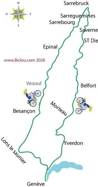
Here’s the deal: claudio finally did the bike trek he’d been planning for N+1 years, heading toward the Northeastern Region of France.
A few highlights: Jura Vesoul Épinal Arbois VéloRoute 50; Northeastern Canals (Saar Canal); Sarrebourg Saarbrücken Alsace Bossue Lorraine Vosges Jura Switzerland
Story and photos coming soon...
Story in progress...
Setting off from Geneva, a bit grumpy, toward the shores of Lake Geneva, we weave through the crowds of wild commuters, but calmly via Versoix, Tannay, Commugny, Founex, Céligny, and finally Genolier, where the real fun begins.
Indeed, while the road from Arzier to St-Cergue and La Givrine offers stunning views of the Lake Geneva basin, the climb is challenging.
But after atoning for a few sins, the village of La Cure is reached as easily as pie.
To avoid the main road and prolong the fun, we opt for the route to Prémanon and Morez via unlikely backroads.
Phew: Lons-le-Saunier at last! Still, quite a bit of meandering to find our campsite.
We lose not only our bearings but also our Michelin map, but eventually stumble upon the hostel—a bit spartan, but at least we’re sheltered.
I’m planning to bike around the Mediterranean.
I’m supposed to go through North Africa, but it seems a bit complicated.
Visas and travel in Algeria and Egypt only work if you book a hotel (no nights spent outside?).
Libya is generally very unclear, and it seems you can only travel there with a local guide (which doesn’t exist for bike trips).
If necessary, I’d skip Libya, but neither a bus ride nor a boat detour seems possible to enter Egypt.
Does anyone have tips on how to get around these issues and secure a visa?
Hi everyone, especially to fellow cycle tourists! I’ve just finished a 25-day bike trip from Tamatave to Diego along the east coast—about 1,300 km, including 850 km of pure dirt tracks and bush. I kept a travel journal, so I’ve got plenty of tips for anyone interested.
See you soon
Hello fellow cycle tourists,
Are there any campsites along the Somme cycle route?
Let’s say every 50/60 km starting from Tergnier.
Thanks for your help!
I’m considering applying for the next edition of the Silk Road (Let’s go crazy 😜). Nothing’s certain, of course—I think there’s a lottery for anonymous applicants.
I’m 67, and my goal is to take part and go as far as possible, without necessarily finishing, let alone making it within the time limits.
I already know Kyrgyzstan from cycling there before. The area’s tough, but the landscapes and vibe are stunning.
I’m open to any advice or suggestions. Also up for a race partner (as a duo or solo).
I live in the Monts du Lyonnais and train daily.
Looking forward to hearing from you,
Thierry
When you think of traveling in Tanzania, you often picture high-altitude treks and 4x4 safaris. However, for those who prefer exploring on two wheels, the country’s vast network of dirt tracks, volcanic terrain, and diverse ecosystems make it one of Africa’s most rewarding cycling destinations.
Whether you prefer challenging alpine climbs, fast gravel trails, or coastal rides, here’s a look at what makes cycling in northern Tanzania so exceptional, along with some of the region’s best routes:
1. Climbing Mount Kilimanjaro by bike (Kilema route)
Terrain: Singletracks through humid rainforest, gravel paths in the moorland zone, and alpine desert scree.
* The experience: For experienced mountain bikers seeking a high-altitude challenge, the Kilema route is the official bike-accessible path on Kilimanjaro. The trail winds through lush rainforest before reaching the open heathlands near Horombo. Higher up, crossing the alpine desert toward Kibo demands endless bike carries and pushes, but descending through the forest canopy remains an unforgettable experience.
2. The full 360° loop around Kilimanjaro’s base
Terrain: Red clay earth, two-track trails, rolling gravel, and volcanic paths (total loop of about 360 km).
The experience: Circling Kilimanjaro lets you admire its landscapes from every angle. The route meanders through Chagga farmlands, coffee plantations, dense forests, and the open Maasai plains of the western side (like the West Kili area). It offers stunning views of Kibo and Mount Meru while passing through local villages.
3. From Kilimanjaro to Lake Natron (descent into the Great Rift Valley)
Terrain: Technical gravel, dry riverbeds (wadis), unstable volcanic rock, and acacia scrub.
The experience: This route takes cyclists from the fertile high slopes of Kilimanjaro to the dramatic, arid scenery of the Great Rift Valley. As you approach Lake Natron, the active volcano Ol Doinyo Lengai (“Mountain of God”) dominates the horizon. The final stretch across the Rift floor leads to the saline, serene shores of Lake Natron, a prime breeding ground for large colonies of lesser flamingos.
4. Wildlife zones and corridors
Terrain: Packed dirt tracks, animal trails, and undulating bush paths.
The experience: Pedaling through the northern circuit’s wild buffer zones and Wildlife Management Areas (WMAs) offers an authentic off-the-beaten-path cycling safari. Riding through acacia woodlands often provides sightings of savanna wildlife like giraffes, zebras, and antelopes in their natural habitat.
5. Coast to coast: From Kilimanjaro to Zanzibar
Terrain: Varied surfaces—from highland dirt tracks to coastal asphalt and sandy island trails.
The experience: Combining the cool mountain air of Kilimanjaro with the tropical Indian Ocean coastline, this long-distance route transitions from mountainous foothills to rural towns before ending at the coast for a boat crossing to Zanzibar. There, you can cycle along white-sand beaches lined with palm trees and through the historic heart of Stone Town.
Practical tips for cycling in Tanzania
Bike choice: A sturdy hardtail MTB, full-suspension MTB, or gravel bike with ample clearance (tires at least 2.0 inches) is ideal for tackling loose rocks, sandy patches, and corrugated tracks. Mid-drive e-MTBs are also popular for handling steep climbs.
Navigation: Using offline mapping apps (like Maps.me) alongside pre-downloaded GPX route files is essential for navigating rural tracks where mobile signal may be nonexistent.
Best time to go: The dry seasons—June to October and December to March—offer the best trail conditions, firmer ground, and clear mountain views.
Tanzania delivers the perfect mix of technical riding, impressive elevation, and cultural immersion right alongside local communities. Don’t hesitate to ask if you have questions about trail conditions or gear to bring!
Hi there,
who has already done the EURO VELO 1 in Norway from the south to the North Cape, and what are the main difficulties:
elevation gain, etc.......
Otherwise, who has already done the EURO VELO 7 from south to north, crossing Sweden up to the North Cape? If so, what are the difficulties, elevation gain, and does it pass through villages for supplies, etc.......
I’ve got my flight ticket sorted—departing in mid-November and returning in mid-March. I’ll arrive in Santiago and leave from Buenos Aires.
I’ve already been to southern Argentina, specifically Torres del Paine National Park, and I’d love to go back to do the full W trek (I only did the shorter version last time).
I also want to do some hiking and maybe even tackle a summit. I climb and occasionally do some mountaineering, so I’ll definitely be going with a guide.
I plan to start around Temuco in Chile, with the idea of heading toward the lakes, then taking the Carretera Austral.
I’m not sure if I’ll go all the way to Ushuaia—it’s supposed to not be *that* worth it, except for the bragging rights of saying you’ve been to the end of the world.
I saw there are lakes in Argentina too.
I don’t have a precise itinerary, but what I’d love is, once I reach the southernmost point of my trip, to take a mini-cruise to see some wildlife. Any tips for that?
What kind of sleeping bag did you take? Is a 0°C (32°F) one enough?
And one last question: white gas stove or can I get by with my gas stove?
I’m landing in Madagascar with a buddy before the end of April 2026. We’re planning to bike around for about twenty days or so. We don’t have a specific goal other than exploring the country and meeting the locals.
Ideally, we’d prefer a loop route starting from Antananarivo with a good chunk of it along the coast. On the bike side, we’re used to riding 6 to 8 hours a day, depending on the needs, encounters, and mood 😉 Any feedback or tips from trips around this length?
Hi everyone,
I’m heading to Madagascar in early October to cycle from Tana to Diego along the east coast.
I really want to visit the Masoala Peninsula and its primary forest. If anyone’s interested, I’m open to company.
Maybe see you soon!
I’d been watching this ultra-light travel movement or trend for a while.
So I gave it a try—goodbye to the 5 panniers and rear racks.
A 15L saddle bag for clothes and a stove cookset.
Two cages on the fork blades: 2x5L—mattress on one side, tent on the other.
A 5L frame bag for miscellaneous items: battery, camera, small bits and pieces.
And one on the handlebar for the sleeping bag.
I tested it this summer on a crossing from Valence to Perpignan via the Massif Central.
My conclusions:
The obvious advantage is the reduced weight. In total, I had 12 kg on the bike, which makes climbing in the mountains much easier.
Another benefit I hadn’t considered is the significantly lower wind resistance compared to a traditional setup—you really feel it when the wind’s against you.
Of course, it’s not all perfect...
For example, it’s impossible to carry a food stock. You buy just enough before each meal or go to a restaurant!
You also have to accept a more spartan comfort level at stops.
In conclusion, I think for summer trips in regions where resupplying is easy, it’s an interesting option—especially if there’s significant elevation gain.
On the other hand, it doesn’t allow for enough autonomy, so some trips are off the table.
On the bike side, I swapped my Shimano 11/34 cassette for an 11/40. Even though Shimano doesn’t recommend it with a 105 derailleur and a 46/30 double chainring, it works really well.
The only limit is avoiding the 46/40 gear ratio.
Hi,
what are the easiest ways to get back from Nordkapp without pedaling—
train, boat, or plane?
Has anyone already done this?
Thanks for sharing your tips!
I’m planning to leave Nice for Toulouse around 10/15 and I’m looking for tips / great deals regarding:
- The route: I was thinking of taking Nice - Grasse - Draguignan - Salernes - Cadarache - Cavaillon - Arles, then the Camargue, Sète, and the Canal du Midi to Toulouse. The idea is to avoid high-traffic roads and too many steep climbs. Are there any spots to avoid or must-see stops? Since it’s been a while since I’ve been on the road, I was thinking that sleeping indoors might be preferable. If you have any budget-friendly accommodation suggestions along part of the route, don’t hesitate!
Thanks in advance, and if you’re in the area around that time, we could ride together... Ciao.
Hi,
I need to arrive in Thessaloniki by bike at the end of September and I plan to head to Istanbul along the coast.
Could anyone help me pick the best route? Safety, difficulty.
Thanks in advance.
Marc
Hi everyone! Thanks for welcoming me to the forum :)
I’m preparing for a long trip heading to Nepal, with stops along the way depending on my mood, work needs, and the season. I cycle a lot, but this will be my first big touring adventure. I’d like to camp regularly to keep costs down, so I’ll be riding on all kinds of surfaces: smooth and rough roads, main highways and rocky paths to find my camping spots, flat terrain and the occasional steep slopes.
For my bike model, I’m prioritizing durability, versatility, and repairability. From that perspective, I prefer a steel frame and fork with rim brakes since I’m used to them. I’ve narrowed my choices down to four models:
- The VSF Fahrradmanufaktur T-700 LTD (1400 €): steel frame, aluminum fork, hydraulic rim brakes, 28" wheels, 40mm tires, 36 spokes (2 mm), lightweight rear rack (max 20 kg), no front rack included, smallest gear ratio of 0.72, weight of 13.9 kg.
- The VSF Fahrradmanufaktur TX-400 (2200 €): steel frame and fork, hydraulic rim brakes, 26" wheels, 50mm tires, 36 spokes (2.34 mm), front and rear racks included (40+18 kg), smallest gear ratio of 0.71, weight of 15.9 kg.
- The Genesis Tour de Fer 30 (2150 €): steel frame and fork, mechanical disc brakes, 28" wheels, 36 spokes, 40mm tires, front and rear racks included (27+10 kg), smallest gear ratio of 0.77, weight of 15.9 kg.
- The Rockrider ADTV 900 from Decathlon (1700 €): aluminum frame and fork, mechanical disc brakes, USB port, 28" wheels, 47mm tires, 28 spokes, front and rear racks included (40+20 kg), smallest gear ratio of 0.71, weight of 17.1 kg. This is the successor to the Riverside Touring 900, which was a hit.
I’ve got a few questions:
1/ Should I go for 26" or 28" wheels for my trip? 26" wheels seem better for rough terrain, but 28" wheels feel more comfortable on roads. I’ve also read that 26" tires/tubes are easier to find.
2/ Do you recommend a steel frame and fork over aluminum? I’m guessing a high-quality aluminum frame and fork would be better than a low-quality steel one, right?
3/ Regarding the smallest gear ratio, is 0.71 a good number for a loaded bike in the mountains?
4/ Finally, what do you think of these four models for my project? My heart leans toward the TX-400—it seems to combine the versatility and robustness I’m looking for. But the price difference with the T-700 LTD is making me think twice!
Thanks so much for reading and sharing your thoughts!
17 days, 1,400 km, and 17,500 m of elevation gain cycling in northern Vietnam! 🇻🇳 🚴🇻🇳
From the misty Fansipan to the breathtaking landscapes of the Ha Giang Loop, from remote villages to vibrant markets...
I cycled through the north of the country, getting up close with its people—through mud, heat, endless mountain passes, and unforgettable encounters.
Most importantly, I discovered a Vietnam far different from the usual tourist circuits.
Join me on this adventure through a video that captures these 17 days of travel. :)
If Vietnam calls to you, come ride a stretch with me!
Hi,
can anyone give us some tips on how to get to North Cape from Lyon Gerland?
What’s the best route to join the EuroVelo 7?
How many kilometers is it from Lyon to North Cape via EuroVelo 7?
The best month to leave—we’re thinking early May.
Thanks for any advice!
Looking for a female travel companion for a cycling trip (arriving by plane in Porto Alegre, Brazil, and cycling toward Montevideo, Uruguay, returning by plane to France from Buenos Aires, Argentina) – 1,500 km
Hello everyone!
I’m planning a cycling trip across Brazil, Uruguay, and Argentina, with a departure set for late October, November, or December. I’m looking for a travel companion to share this long-distance adventure with.
Experience:
I already have solid experience in bicycle touring in Georgia, Kazakhstan, and Kyrgyzstan. Currently, I maintain excellent physical condition by cycling an average of 250 km over 3 days per week (4 hours a day at 20 km/h).
The trip & the pace:
Daily pace: Between 50 and 80 km per day, to make steady progress while taking time to explore.
Accommodation: Flexible and authentic. We’ll alternate between wild camping, campsites, Warmshowers, small guesthouses, and budget hotels depending on opportunities and the weather.
Looking forward to reading your message and planning this amazing journey together!
Another long-time dream of Claudio’s: the Petit Mont Cenis pass and the dam at the eponymous lake.
A place where many Italians, including my father, worked in the 1950s–60s.
Faverges → St-Michel-de-Maurienne → Lanslebourg → Petit Mont Cenis → return. 315 km, 3 days. Bivouac at St-Michel-de-M.
Brouter link
Leg One: Faverges → St-Michel-de-Maurienne
Leg Two: St-Michel → Lanslebourg → Mont Cenis Lake → St-Michel
Leg Three: St-Michel → Faverges
And it finally happened in August 2026: in the Maurienne Valley about the famous cycle route known as the V67
🇷🇼 Cycling in Rwanda: 4 episodes, an off-the-beaten-path adventure
After 3 weeks and nearly 1,200 km by bike across Rwanda, I made 4 videos to share this adventure in a different way: the landscapes, the encounters, the villages… but above all, all those incredible scenes of everyday life.
The 4 episodes are available here:
👉 https://www.youtube.com/playlist?list=PLGnfbxjccWAg
The 4th episode focuses on rural Rwandan life: simple, authentic, and sometimes surprising scenes that you only truly discover when you take the time to travel by bike.
If you have a few minutes, let yourself be transported to Rwanda…
Hi,
We bought the MSR bike tent model (2-person + large awning that can fit 2 bikes) back in 2005. It’s served us really well, especially during a year-long trip in Africa. Now, one of the poles is broken, and we’d love to replace it since that’s the only issue with the tent—we still love it! The poles are 9.35 mm in diameter, with 8 sections of 49 cm and 2 sections of 28 cm. Total length when assembled: 416 cm. Actually, two large sections are broken: one straight and one curved. It’s a pain to find replacements since this model is no longer sold anywhere.
Would anyone have this model lying around unused and be willing to sell me a pole?
Hi everyone,
In early April, I’m redoing the Vélo Francette (La Rochelle to Ouistreham), and then I’d like to cycle along the Cotentin Peninsula (which I don’t know at all), follow the coast up to Cherbourg, and then head back down to at least Saint-Malo. I’d love to know if it’s pleasant for cycling—are the roads nice? Not too windy? What are the must-see spots? Any great campsites? All your tips and advice are more than welcome, and I thank you in advance.
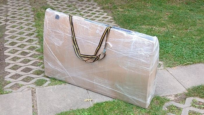
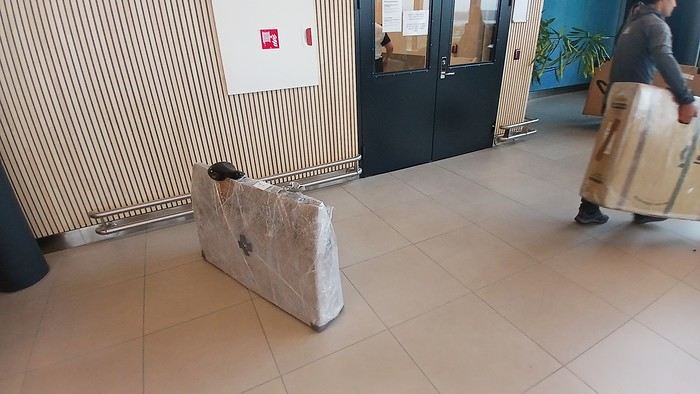
After testing it for three years across various modes of transport, I’m sharing this video of a bike packing case. It’s made from recycled cardboard and shrink-wrapped, with adjustable thickness and added bubble wrap depending on the level of protection you want.
Installing spacers at the fork and chainstays makes the packaging compact. With the fifteen-odd euros for shrink-wrapping at the airport, this case travels really well.
https://youtu.be/_GDJi-GqmkM
- Low bulk (1.10m x 0.70m x 0.25m for a large frame), it fits vertically in train luggage compartments and the total dimensions (x+y+z) don’t exceed 2.40m.
- Two carrying solutions for public transport and easy handling by airport staff (no more tears in the cardboard from openings).
- Discreet packaging when dealing with bus drivers and train conductors, as it looks like an ordinary parcel.
- No need to return to the starting point to retrieve the case from your outbound trip, which you’d otherwise have to store somewhere, or deal with a bulky cover to pack in your panniers.
- You can still check tire pressure through the plastic film without damaging the packaging too much.
Drawbacks: Around 3 hours for this lengthy and meticulous process—removing the wheels, pedals, handlebars, and derailleur without misaligning them, then securing all components to the frame.
If you get a chance to test it, send me your feedback for future improvements.
I just took a trip in Tunisia from Tozeur to Douz, skirting Chott el Jerid to the south. I’m back with the urge to keep going further south via the 4x4 tracks to connect Douz to Ksar Ghilane. Has anyone driven this route recently or explored southern Tunisia?
Thanks for your tips!
fix