Avez vous grimpé un 5000m au Chili avec petit denivelé, genre on monte en 4x4 le plus haut possible sur une piste pour finir qqs heures de marche pour atteindre le sommet.
Le Toco a SPA ça vous dit qqs chose...?
Près de Parinacota dans le parc du Lauc y aurait un 5000 à faire ?
Et le Lascar ......
Si vous avez fait un de ces sommet vous pouvez peut-être me donner des infos...accès, dénivelé, horaire....
Merci d'avance
Charles
PS j'ai une petite expèrience dans les alpes Mt Blanc Ercrins........
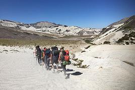
Depuis SPA, le Lascar est ce qu'il y a de plus simple. Je l'ai fait en 2h en Mars dernier avec une approche depuis SPA en 4x2 et c'était parfois un peu juste dans le sable (il ne faut pas s'arrêter). Sinon, tu as le Miniques qui se trouve au pied de la Laguna Miscanti, mais c'est déjà plus long. Le Licancabur se fait très facilement depuis SPA également. De toutes façons, dans ce coin, il y a tellement de possibilités que c'en est indécent.
Près de Parinacota ou Sajama, tu as le Guane Guane qui fait un peu plus de 5000 et qui se fait depuis Parinacota en une après midi. Il y a aussi le Nevado de Putre qui est au dessus du village du même nom. C'est un joli sommet qui fait pas loin de 5900m et qui se fait depuis Putre en un ou deux jours. Le top reste dans ce coin de faire un des trois géants (Parinacota, Pomerape ou Sajama).
Ton expérience alpine, elle ne te servira pas à grand chose, en revanche, prends du temps pour t'acclimater.
A+
"Old travellers never die, they just smell that way"
🙂 ..... petit clin d'oeil à un ami voyageur ..... toujours content de te lire et d'avoir quelques nouvelles ....
Tu serais donc rentré apparemment ....... ? je serais en Argentine/Chili en Janvier/Février probablement .... une chance de t'y rencontrer ou pas ..... ?
Salut et merci de ton mot,
Si j'arrive à mener ma barque correctement il se pourrait que je sois dans la Puna argentine (région de Catamarca et La Rioja) en Janvier pour retenter un sommet s'étant montré récalcitrant et pour en découvrir un ou deux autres.
Bonne soirée
"Old travellers never die, they just smell that way"
Pour l'approche du Lascar est ce facile à trouver (faut-il un guide) y a t'il un risque de mines dans ce coin?
Jusqu'a quelle altitude es-tu monté avce ton 4x2 ?
Pour l'ascension y a t il un sentier, une voie conseillé, on a lu que si le volcan fume il faut changer de voie?
Le paysage au sommet vaut le coup? vue sur l'altiplano?Peut on voir le site astro Alma?
Pour le Guane Gunane le départ à pied c'est depuis le village de Parinacota(pas de piste à faire en voiture tt)
Y a t il un sentier, des cartes à se procurer(pour le lascar aussi)?
Oui on prendra le temps de s'aclimater en faisant des virée en en altitude avec un peu de marche...bref t'a des conseil pour s'aclimater avant de faire un petit 5000
Merci d'avance
@+
Charles
il se pourrait que je sois dans la Puna argentine (région de Catamarca et La Rioja) en Janvier
Alors tu remets ca? 😉 Incorrigible Gnome va!
Mais c'est bon de te lire a nouveau, je me demandais deja combien de temps il te faudra pour reprendre du poil de la bete. tu retournes chercher tes chaussures? 😏
Non, mais ça existe en Bolivie :
Bolivia : l'UTURUNCU, un 6000 facile.
Ascension de l'Uturuncu 6.020 m, près de Quetena. L'Uturuncu (le tigre) est sans doute le sommet de plus de 6000 mètres le plus facile. La présence d'une ancienne mine de souffre à 5.900 mètrs permet de profiter de la piste carrossable la plus haute du monde, elle monte jusqu'à 5.600 mètres.
Alléchant, non ?
JPB 😎
Pour l'approche du Lascar, ce n'est pas sorcier, mais à 2 (sans guide et aguérris à ces coins) on a tout de même réussi à se perdre un peu et à s'enliser avec notre camionette (ca fait des souvenirs). En fait, avec les cartes classiques (genre celles du Turistel) tu peux te rendre sans trop de problèmes jusqu'à la laguna Lejia. Juste avant la laguna, il faut que tu prennes à gauche sur de vagues traces dans le sable. Pas de panique, au bout de 5 à 6 bornes de sable (surtout ne pas ralentir si tu n'es pas en 4x4) tu verras que tu n'as pas d'autres solution que de monter à l'assault du Lascar en voiture. Il n'est pas si impressionnant ce lascar d'ailleurs... Sauf en cas de forte activité volcanique por supuesto ! Tu peux monter vraiment haut en voiture et trouver un endroit plus ou moins plane pour ta tente. Surtout ne te réveilles pas trop tôt pour l'ascension... on l'a faite en 2 heures et 1heure pour la descente (ou quelque chose comme ça). La voie est tellement évidente que tu peux sortir des quelques traces à ta guise. Il y a 3 sommets et deux cratères. tu auras tout le temps de les faire sans te presser. Celui qui fume est bien entendu le plus impressionnant, même si les fumerolles peuvent te décourager de t'en approcher si le vent souffle vers toi. l'altitude maxi est aux alentours de 5600m. La vue depuis le sommet ? Bof. Si c'est ton premier sommet "altiplanesque/punien" alors tu adoreras (ne serait-ce que pour la vue sur la laguna Lejia et le cratère qui fait penser à une porte sur l'enfer). Si tu as déjà fait quelques sommets dans le coin, alors tu trouveras la vue moyenne. Le site astro lama ?... Que es ? Pour une vue de folie dans la région, je te conseille le sommet du Miniques... Juste GRAND ! Et puis je ne te parle pas de la vue depuis le sommet du Licancabur. Pour quelques infos supplémentaires et photos, clique ICI et va faire un tour aux environs des 6, 7 et 8 Mars.
Guane guane : départ à pied du village Parinacota. Il y a une piste que tu peux prendre presque jusqu'au pied de cette grosse colline. Pareil que pour le Lascar : "la voie" est évidente ! Au pire, tu demandes à un habitant du village ses conseils sur la météo... au cas ou il y aurait des risques d'orage (ca rigole pas là bas les orages, surtout les tourmentes éléctriques). La vue depuis cette grosse bosse est vraiment superbe : les payachatas (Parinacota, Pomerape et toutes les lagunas du magnifique parc Lauca. Attention, même si ca parait près, la balade te prendra au bas mot 5 à 7 heures. Pars avec des fringues chaudes même s'il fait un temps magnifique à Parinacota.
Idées pour s'acclimater dans le coin de SPA : faire des balades à la journée (guidées ou par soi-même, c'est aussi simple avec une voiture de loc) du genre lagunas Miscanti et Miniques; route 27 qui mène au Paso de Jama (Argentine), Geysers del tatio (et faire un des petits sommets surplombant le site), etc.
Pour ce qui est des cartes, si tu ne veux pas te ruiner, je te conseille d'acheter le guide Turistel Norte qui est très bien fait. Avec ça et Google Earth, tu sera vraiment bien paré.
A+
"Old travellers never die, they just smell that way"
Alors, tu te demandes bien où tu pourrais trouver un glacier arrivant à la cheville de Persicco ? Cherches pas, ça n'existe pas !😛
Je ne suis pas encore reparti, mais j'y pense quand j'en ai le temps...
Mes pompes ?... Pfffffffffff retrospectivement, je suis vert de les avoir laissées dans la poubelle du refuge du Llullaillaco... J'espère simplement qu'un militaire s'en sera emparé pour leur donner une seconde vie !
A+
"Old travellers never die, they just smell that way"
Merci beaucoup pour tout ces détails, les conseils et les photos 😉,
On verra bien sur place et on fera suivant notre niveau d'aclimatation.
J'ai pas précisé mais notre voyage c'est cet été....l'hiver austral c'est peut pas trop la saison pour les rando à HA?
Le projet Alma concerne Chajnantor un plateau situé à une quarantaine de kilomètres à l'Est de San Pedro d'Atacama, à une altitude de 5200 mètres. C'est le site retenu par la communauté scientifique internationale pour y installer à l'horizon 2010 un des instruments au sol les plus ambitieux jamais construit, à savoir l'ALMA : Atacama Large subMillimeter Array, qui consistera en un interféromètre de 64 antennes de 12 mètres. Compte tenu des conditions de vies très dures à cette altitude, ALMA sera géré entièrement depuis un site à une altitude inférieure (3000 mètres) dont la construction n'a pas encore été commencée.
Pour l'intant qqs antennes on été installées......
Si tu veux plus d'infos voir le site web d'Alain Maury
Je cherche un trek d' altitude et à franchir les 6000 m sans pour autant devoir être trop dans l'alpinisme dont j'ai peu d'expérience. A mon actif, le Toubkal,…
Je me permets de faire appel à vous car je prépare un voyage au Chili pour la fin du mois de mars et j'ai quelques interrogations, notamment concernant la…
Au mois de novembre 2016, nous serons dans le parc de Conguillo. Nous voudrions avoir des infos sur l'ascension du Sollipulli. Est-ce que ça en vaut vraiment…
J'ouvre ce fil suite à quelques questions que j'ai eu suite à un message posté ici: voyageforum.com/... Voici donc quelques informations utiles concernant…
Voyager à pied › Chili / Bolivie / Argentine · 9 replies
Je pars 4 mois en Amérique du Sud et je souhaiterais faire l'expérience d'une ascension d'un volcan au Chili. Il y a en beaucoup et j'aimerais vos retours…
Bonjour,
Nous souhaitons faire le trek de 4 jours reliant Mestia à Ushguli sans agence. Il est précisé dans les descriptifs qu'il existe des hébergement à chaque étape, mais on ne trouve pas d'info sur ces hébergements. Quelqu'un a-t-il des infos et un avis sur ce parcours?
We're planning to trek in Peru and Bolivia and would love to find some local agencies.
If you know any, could you share details on prices and, of course, the names of the agencies?
Which trek would you recommend?
Elocine
Je pars en autonomie totale sur un trek au Maroc (10jrs) Imilchil - Aghbalou.
Trouve t-on des cartouches gaz à vis (Coleman, Primus) à Marrakech (adresse) ou villages entre Imilchil - Aghbalou ?
Si non , trouve-t-on des cartouches Butagaz pour camping-gaz (petit volume 230 gr ...)
Merci d' avance pour vos réponses
Hello, I’d like to embark on a little trip in my home country, Switzerland. I’ll start walking from La Cure, heading toward Le Noirmont first, then I’ll improvise my route—but it’ll probably follow the French border... at least as far as Lac de Joux.
I’ll decide day by day how much farther to go after that. My goal is to stay in nature as much as possible, wander around for as long as I can, and restock food in villages or towns along the way.
I’m thinking of mostly camping, but we’ll see if I end up in a hotel or another campsite depending on my route.
I’d love to reach La Chaux-de-Fonds on foot... maybe even Delémont.
The whole thing should take about a week, give or take.
I’ll be bringing my dog, and I’m preparing for this as soon as I’m ready.
Any tips to make sure everything goes smoothly for us? Things I should know—or avoid? What about shepherds with their flocks of sheep? And isn’t hunting season open right now?
I’m not sure if what I’m planning is even doable, which is why I’m asking around.
This’ll be my first time doing something like this—wandering in nature *and* with a dog. I’m really excited for this adventure... and I need it. Thanks!
We’re really keen on ecosystems and want to hike in "natural" ancient forests—not planted woods or areas heavily degraded by human activity. Travel guides (like Lonely Planet) don’t provide much info on this. Could you point us to the most interesting spots?
Thanks in advance for your tips.
We wish you happy holidays and a fantastic 2026, full of discoveries!
Claire and Albert
Hi, this might not be the right section, but I’d like to know if it’s possible to start mountaineering with another person without necessarily hiring a guide. We’ve done quite a bit of hiking but not mountaineering—we’ll just do a half-day glacier course. After that, we were thinking of starting with La Grande Motte and the Pointe de la Traversière, which were recommended to us. Honestly, for things like roping up and knots, I’ll learn at home with lots of videos and a book.
Hi,
I don’t know Switzerland at all and was wondering if Vallée des Joux and especially Dent de Vaulion are packed early in the morning or late in the afternoon in July and September?
If so, do you have any quieter spots to recommend in the area, or in Luxembourg (yes, I know it’s not the same country 😉)?
Thanks a lot!
Jaimerais savoir si quelqu'un aurait fait des treks sur le Ruwenzori et combien ça coute en moyenne, les infrastructures, les paysages la sécurité sur les lieux, merci beaucoup. J'attends avec impatience vos réponses.
We’re leaving in 9 days for a two-week trip to Madeira, mainly to hike.
From my research, I’ve found that since last year, access to most trails—and systematically for the most popular ones—is now paid. You have to pay an access fee of 4.50 € per person per classified hike in 2026, and even 10.50 € for the most iconic hike: Pico Arieiro to Pico Ruivo. When paying, you also have to choose a day and a 30-minute time slot for your start time. Of course, this reservation is neither changeable nor refundable, even if the weather that day is terrible.
Personally, given the massive influx of tourists to the island in recent years, I don’t mind paying a fee to help maintain the trails. Similarly, setting a limit on the number of people who can hike them per day is certainly preferable to preserve this priceless heritage.
However, what’s much less fair is that in reality, most of the available spots are reserved: 1/ for Madeira residents (which is normal); 2/ for "economic operators" (meaning local tour operators). For example, if you’re a non-resident (independent tourist), no booking is possible for the Pico Arieiro hike for an early morning start before September! So, unfortunately, we’ll have to skip this hike.
It’s the same issue for Ponta de São Lourenço, the 25 Fontes, Pico Ruivo... in short, all the most popular hikes. Oh well, we’ll skip those too!
So my question is: which hikes do you recommend where we won’t face the huge crowds that the others get? And where we can book the day before for the next day, taking the weather into account?
Finally, a quick accommodation question: we’ve booked the first week in Funchal, but I haven’t decided yet for the second week. Do you have any advice on where to stay in the south or north, preferably avoiding overly concrete-heavy and touristy spots?
I’m reposting about the logistics for Samaria Gorge.
I’d love to get recent info, especially about whether it’s possible to park my car in Omalos, do the hike, and then catch a bus back to my vehicle.
In theory, it’s doable, but when you check the KTEL website, there aren’t any feasible schedules listed. If anyone has recently organized this with reliable, verified details, I’d really appreciate it. Thanks in advance!
Hi there,
We’re flying from Montreal to Lyon this August to go hiking in the French Alps. We’ve rented a car and will be staying at campgrounds. We’re planning to do day hikes and want to stay a few days in one spot, do a few hikes, then move on to our next camping spot. Could you share your favorite spots or any recommendations for places to spend a few days with great hikes?
A few details:
We arrive in early August and leave in early September.
We’re looking for day hikes (or shorter), moderate difficulty, with a cumulative elevation gain of no more than 1000m, and of course, beautiful scenery!
We’d prefer not to drive too much—maybe it’s best not to head too far south and deal with unnecessary heat?
Along the same lines, if you know of any great campgrounds where we can start our hike directly without needing the car, we’d love to hear your suggestions!
Bonjour
Souhaitant faire de la randonnée sur cette île, je voudrais d'abord savoir quelle serait la période la plus favorable sachant que j'avais passé quelques jours en novembre 2018 pas pour cette activité mais plus pour une simple découverte de l'île et le temps n'était pas top notamment en montagne. Donc peut on choisir une organisation en étoile sachant que je louerai un véhicule avec éventuellement 2 points d'hébergement.
Je n'envisage pas d'intégrer une structure mais de partir à 2 et de s'organiser sauf si vous me conseillez une agence locale ou un guide local. Enfin même si je compte me procurer les différents supports, carte et topo guide plus gps je vous remercie de bien vouloir me communiquer les randos à faire en priorité
Merci beaucoup pour vos informations
I’m planning to do the Mercantour crossing following the Randoxygène route in mid-July.
I’m used to hiking in the mountains, but I sometimes get vertigo, for example on ridges with drops on both sides. I wanted to check if there are any T4 or T3-T4 sections and find out if there are any very exposed passages—and if so, where—so I can plan an alternative route.
Can anyone give me some info on this?
Thanks!
I’m planning a trip around Cap Corse and the AGRIATES in 2026, from May 8th to 15th (there are still 2 spots left, by the way! Just DM me if you're interested).
I’d love to know which hikes are worth prioritizing in the AGRIATES. We’ll be staying in SALECCIA for two days as our base—what should we focus on from there?
A round trip to IGNHU beach? Any other suggestions?
For Ostricano, I think it’s too far for a round trip...
Thanks for your tips!
Have a great day,
Anie, Toulouse
I’d like to get some info about the GR10 Pyrenees traverse. I need help planning the daily stages and accommodations—my wife isn’t an experienced hiker but walks a lot, so I’d like to schedule shorter walking days and thus a longer overall trip in terms of number of days.
Could anyone give me some help and advice?
Best regards,
New to this forum, I’m planning a pretty big project for 2028.
I’m heading to Nepal to do a trek from Kathmandu all the way to Everest Base Camp (a cool 5,300 m 😄).
This trek is a bit special because even though I’ll be part of a group, I’m going solo (so far, no problem—I’m used to it). But it’s my first real trek, and it’s also a humanitarian one: once I reach base camp, I’ll stay an extra week to help clean up the waste left by tens of thousands of climbers! Since I’m originally from South America, from two countries that share the Andes, I have a deep respect for mountains—they fascinate me. So Everest… it’s kind of the trip of a lifetime!
So, a little question for those who’ve done treks to Everest before… any tips for good mental preparation (I’m already working on the physical side)?
Hi there, I’m planning the Annapurna Circuit for March 2027 and I’m looking for a local agency with a local guide—preferably French-speaking—to arrange this trek for us. Any suggestions? Thanks
Hello!
We’re spending a few days in Toraja country at the end of May. We’d love to do a day trek—taking our time—on a route that’s stunning in terms of scenery, but not a level 5 in difficulty!
Any suggestions you can share, please?
Thanks in advance
I’d like to do the Mare a Mare Sud in May over 4 days. I’ve found quite a few places to stay along the route, but I’m stuck on the start and finish.
I’ll be arriving by plane on Sunday evening and would like to start pretty early on Monday morning. Ideally, accommodation right at the trailhead (Alzu di Gallina) would be amazing, but I can’t find anything. Any tips?
Also, for the transfer from Figari Airport to Porto Vecchio or Alzu di Gallina?
At the end, I’d like to pick up a rental car—any advice on that too?
I’m traveling solo by plane to Catania in May and plan to hike the northern side of Etna, starting from Linguaglossa where I’ll arrive by bus. After that, I’d love some info on how to get up to Piano Provenzana (shuttles or hitchhiking), since it seems there’s no public transport except in the summer. Can you sleep there in a free or cheap refuge, or camp? And how far up can you go without having to hire a guide? Thanks in advance. Bernard.
Bonjour a tous,
je pars en voyage au Maroc en aout et nous allons commencer par nous arrêter a Chefchaouen(nous sommes en voiture).
Ma question: quelqu'un peut il m'indiquer un itinéraire de rando en boucle d'entre 5 et 7 jours aux départ de Chefchaouen dans le parc de Talassemtane passant si possible par le pont de dieux?Ou un guide papier qui en reunis quelques uns?
Nous privilégions le camping sauvage et les gites.
Merci d'avance
Hi there, for those who’ve been recently—is it possible to find other solo travelers in March on the island to share transport or room costs? It doesn’t seem easy to travel on a budget.
If you have any recommendations for simple lodgings or places with dorms, I’d love to hear them.
For those who’ve done multi-day treks while moving around: do you need to bring your own sleeping bag? I’d love to hear about itineraries you’ve done without a guide, just with a map and GPS.
Thanks, and have a great day!
Hi everyone!
We’re planning a 15-day road trip to Scotland this summer, specifically to explore and hike on Lewis and Harris—places we’ve never been before. We’ve visited other islands on previous road trips in Scotland (we usually go in April for a week). This would be our first time in Scotland in the summer and for 15 days. We’re looking at late August to early September.
I’m currently drafting the itinerary. We’d be crossing from Ullapool and were thinking of spending 3 nights on Harris and 4 nights on Lewis.
Does that sound balanced to you? Is it better to keep the same accommodation on Harris and the same on Lewis to explore the area? I’d love to hear about any past experiences you’ve had on these islands.
Thanks!
Hi there, I’m trying to leave for 15 days very soon to São Vicente. I’m either looking to join an agency or figure things out on my own to go hiking on one of these islands or both. From what I’ve seen, it’s not easy to organize with local transport, so it gets expensive. Can I use the services of a small local agency? I’m looking for the simplest way to hike for several days. Also, how do you get from São Vicente to São Nicolau? Thanks in advance and have a great day!
Aichatou
I’ve been wanting to do this for several years, and this year’s the one. Next September, I’ll be trekking in Tusheti (Georgia), from Omalo to Shatili.
Of course, I won’t be renting a vehicle that’d just sit unused. No problem getting to Pshaveli, but from there to Omalo, it’s a dirt road (still the case?)
There must be some form of public transport since there are so many guesthouses, and not all travelers come in a 4x4.
If any of you have been to Omalo, could you confirm that these shared transports exist and how often they run?
we’re planning a trip to Yellowstone and hoping to do a three-day backcountry hike if we get a permit.
if any of you have done this before, could you let me know if it’s possible to find water along the way? And if we can transport it, are we allowed to use a stove?
Hello,
I’ll be in Nepal from March 6th to 29th (we’re flying into Kathmandu via Varanasi and leaving via Delhi).
I’m a bit confused about the regulations requiring a guide.
My wife and I (we’re 63 and 64) aren’t experienced trekkers—we’re more used to walking on terrain with very moderate elevation changes. I’m looking for fairly easy hikes, possibly day trips.
Here are my questions:
- Does the Poon Hill trek from Pokhara require a guide, or is it better to go through a local agency? (I’ve seen a lot of them offering 4-day packages)
- I’d like to do a few multi-day hikes around Jomsom (Kagbeni, Mukitinath, Lupra, Marpha)... Do you need a guide for those, and can you find accommodations easily without booking in advance?
Last question—I’m really hesitant to lug around a sleeping bag or down jacket during our 6 weeks in India. Can you easily find these kinds of items at reasonable prices in Pokhara?
Thanks in advance for any tips you can share!
Yann