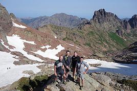
Je suis nouveau et désespéré dans le choix des chaussures de randonnée. J'envisage de faire la partie nord du GR20 fin août avec ma copine. Etant étudiants nous n'avons pas un porte monnaie à rallonge surtout quand il s'agit d'acheter tout le matos (sac, tente, duvet...).
Je me suis beaucoup renseigné et finalement je me demande si les Forclaz 600 de Decath ne peuvent pas faire l'affaire pour une semaine. Est ce qu'elles vont tenir toute la semaine? est ce que la semelle est assez bonne pour ne pas se taper des ampoules et mal au dos? Finalement, est ce qu'elles sont adaptées pour cette sortie, si on ne recherche pas un millésime?
Ps: en partant sur le critère budget, quels confort de duvet me conseilleriez vous (niveau température)? et quelle contenance pour les sacs (ma copine est un ptit gabarit😕)?
Je veux pas vous demander de m'organiser ma rando mais je suis totalement pommé au milieu de toutes les infos contradictoires qui ne me permettent pas de trancher!
j'utilise ça (ou le modèle antérieur - équivalent en type de semelle et de fabrication...) depuis qqs années - bilan ... qqs rando alpines 4-7 jours en autonomies - treks au Népal (CDB Everest, Langtang, Tour et sanctuaire des Annapurnas) + utilisation "courante" .... donc, pas mal de km et d'ascensions au compteur et totalement satisfait :
- en terme de confort : adaptation immédiate, jamais eu d'ampoules, mal au pied, etc ....
- adhérence : bonne semelle .... bonne adhérence dans à peu près toutes les conditions ...
- tenue du pied : correcte .... mais ça reste des chaussures de hauteur "moyenne" : ça ne gêne pas la marche, mais ça ne tient pas la cheville comme des chaussures d'alpinisme ... Pour moi, et pour des chaussures de rando, hors utilisation engagée en haute montagne, c'est un excellent compromis ...
- imperméabilité : limitée ... mais pour avoir testé d'autres chaussures, totalement imperméables, dans des conditions "limites" (pluie battante, ruisseaux, neige mouillée ...) je n'ai pas eu les pied moins mouillés qu'avec celles-ci !!!
- épaisseur de la semelle : limitée aussi ... donc sur "gros cailloux pointus", on sent le sol !!! - Perso, j'utilise la pointure "un peu au-dessus" et je mets une semelle intermédiaire (sorbothane, pour moi, que j'utilise avec toutes mes chaussures "de marche" ...)
Bref très content du modèle et du prix (du coup, je n'utilise pratiquement plus mes chaussures de montagne...)
Bon GR20 ...
Bonjour, pour les sacs de couchage, je pense qu'il faut mini entre du 0° et 5° car il peut faire froid en altitude, après si ton budget est limité, tu devras sûrement t'orienter vers du synthétique ( moins cher mais plus de volume et moins chaud) car les sacs en plume/duvet sont cher mais ils ont l'avantage d'être léger et très compact. Pour les sacs, il faudrait savoir si vous partez avec la totale (tente, sacs, matelas et la bouffe matin midi et soir) car si tu pars avec quelques jours en autonomie totale ça monte très vite, je dirais que vous aurez entre 8/14kms pour madame et 14/20kgs pour toi. Pour te donner une idée, nous partons cet été pour le GR 20 avec du matos léger (tente, sacs de couchage, et matelas) avec 4 jours de nourriture du midi avec petit dèj pour 6 jours, 2l d'eau pour ma femme et 3 pour moi et on aura environ 7/8kgs et 13/14kgs😉 Je te passe tout le détail de ma liste, mais bien sûr il y a plein de chose à prendre, comme des fringues, l'appareil photo, trousse de pharmacie etc... si tu veux je peux te passer une liste type😉
Bonjour merci beaucoup pour les infos! Du coup je vais utiliser un vieux duvet de mes parents qui est quand même moi compact que ceux de decath mais est "confortable" à -5°.
Oui ta liste m’intéresserai beaucoup =)
C'est vrai qu'en surveillant notre budget on va rogner sur le confort (pas le poids) mais bon on essaiera d'atteindre le juste compromis. On veut embarquer un maximum de nourriture mais on se limitera en fonction du poids, et on exclut pas de se ravitailler de temps en temps dans les refuges.
Bonjour, pour les sacs de couchage, je pense qu'il faut mini entre du 0° et 5° car il peut faire froid en altitude, après si ton budget est limité, tu devras sûrement t'orienter vers du synthétique ( moins cher mais plus de volume et moins chaud) car les sacs en plume/duvet sont cher mais ils ont l'avantage d'être léger et très compact. Pour les sacs, il faudrait savoir si vous partez avec la totale (tente, sacs, matelas et la bouffe matin midi et soir) car si tu pars avec quelques jours en autonomie totale ça monte très vite, je dirais que vous aurez entre 8/14kms pour madame et 14/20kgs pour toi. Pour te donner une idée, nous partons cet été pour le GR 20 avec du matos léger (tente, sacs de couchage, et matelas) avec 4 jours de nourriture du midi avec petit dèj pour 6 jours, 2l d'eau pour ma femme et 3 pour moi et on aura environ 7/8kgs et 13/14kgs😉 Je te passe tout le détail de ma liste, mais bien sûr il y a plein de chose à prendre, comme des fringues, l'appareil photo, trousse de pharmacie etc... si tu veux je peux te passer une liste type😉
Bonjour,
Si vous le voulez bien, je serai pour ma part très intéressé par votre liste type.
Merci par avance !
Cédric
Bonjour Cédric, voici ma liste type, celle-ci peut varier en focntion du lieu de rando, entre les Alpes du nord et la Corse par exemple, il faudra plus de vêtement chaud alors que pour la Corse il faudra avoir des vêtements lèger (mais il faut aussi du chaud en cas de mauvais temps) et une grosse gourde pour celui qui boit beaucoup comme moi😉 Par ailleurs si tu emportes ta tente cela change aussi car ça impose notamment un duvet et matelas etc...Bonne préparation.
sac à dos, polaire, pantalon, veste gore tex, T-shirt 1, T-shirt 2, T-shirt manche longue, paire chaussettes 1, paire chaussettes 2, sous-vêtements slip 1, sous-vêtements slip 2, gants, chapeau, short, sursac sac de rando, gourde 3L, lunettes, drap de sac, tente 2 places, sac de couchage, matelas, bâton, frontale, chaussures, trousse de secours, couteau, couvert cuillère, bol plastique, feuilles sopalin, serviette et gant micro fibre, brosse à dents, stick lèvres, boules quiès 1 paire, kleneex 2, 1 PQ, appareil photo+ batteries+chargeur +housse, portable, topo+infos refuges, cartes CAF, cartes vitale, carte CI, argent, grand+ petit sac kway pour la nourriture, sandales, montre alti/baro/boussole, paquet de biscuits ou pain d'épices, barres céréales, P déj du matin avec lait lyophilisé et chocolat, pain, saucisson , fromage
quelle contenance pour les sacs (ma copine est un ptit gabarit😕)?
Si ta copine est un petit gabarit, il ne faut pas dépasser 10kg. Nous avions, cet été, ma fille et moi, un sac de 50L qui faisait +/- 10kg (avec l'eau et la bouffe). Nous n'avions pas de tente, sinon, tout tenait avec cette capacité.
Merci beaucoup pour ta réponse rapide.
As-tu emporté un réchaud et si oui quel type ?
Concernant l'eau, est-il possible de se ravitailler entre 2 étapes ?
Merci et à bientôt
Cédric
Bonjour, non je n'ai pas emporté de réchaud, il y a du gaz dans tous les refuges et gratuit, si tu payes ta nuitée. Pour l'eau cette année avec les précipitations du printemps, nous avons eu de l'eau presque partout, souvent pendant les étapes. Disons que si tu pars comme moi avec 3L d'eau mini, notamment sur des étapes courtes cela suffit, par contre quand on a doublé avec les grosses chaleurs on a dû reprendre de l'eau, l'exemple entre Corrozzu et Tighjettu en passant par les crêtes nous avons bu 9L à deux!!! dont 2L pris au pied du cirque de la solitude🙂 Je précise que ma femme avait une gourde de 3L qu'elle remplissait avec 2 l pour les étapes courtes et au maxi lors des grosses journées, et pour ma part j'avais 2 gourde de deux litres, idem 3L lors des petites journées et 4l lors des grosses jounées. Comme je l'ai dit, je bois beaucoup, donc il me faut mini 3/4l par jour voir 5/6l sur les grosses étapes😊
Les histoires d'eau c'est assez personnel.
Pour ma part j'ai fait le GR20 fin juin, temps beau et chaud sur la moitié nord, forte chaleur sur le moitié sud.
Moyennement chargé (pas de tente mais pas mal de bouffe).
J'avais seulement 2 gourdes de 1 litre chacune.
Je me suis servi de l'une tous les jours, et l'autre était remplie au tiers, en réserve au fond du sac, et je ne l'ai utilisée qu'une fois ou deux.
(il a du nous arriver 4 ou 5 fois de refaire partiellement le plein en court d'étape lorsque la source était parfaite).
J’ai plusieurs questions concernant le GR20 en termes d’alimentation. Nous pensons le faire début septembre et on aimerait être le plus autonome possible…
Ns envisageons de faire la partis Nord de la GR20 en Aout/Sept 2018. Q: Est-ce que les refuges sont propres? et Est-ce que nous devons faire nos reservations à…
J'ai pour projet de faire une partie du Gr20 l'été prochain, surement avec une amie. Je suis un peu sportive mais pas au point de le faire entièrement, j'avais…
Je prévois faire le GR20 en Corse cet automne et je cherche une agence pour me joindre à un groupe. Pouvez-vous me donner votre avis sur Corsica Aventure si…
Bonjour,
Nous souhaitons faire le trek de 4 jours reliant Mestia à Ushguli sans agence. Il est précisé dans les descriptifs qu'il existe des hébergement à chaque étape, mais on ne trouve pas d'info sur ces hébergements. Quelqu'un a-t-il des infos et un avis sur ce parcours?
We're planning to trek in Peru and Bolivia and would love to find some local agencies.
If you know any, could you share details on prices and, of course, the names of the agencies?
Which trek would you recommend?
Elocine
Je pars en autonomie totale sur un trek au Maroc (10jrs) Imilchil - Aghbalou.
Trouve t-on des cartouches gaz à vis (Coleman, Primus) à Marrakech (adresse) ou villages entre Imilchil - Aghbalou ?
Si non , trouve-t-on des cartouches Butagaz pour camping-gaz (petit volume 230 gr ...)
Merci d' avance pour vos réponses
Hello, I’d like to embark on a little trip in my home country, Switzerland. I’ll start walking from La Cure, heading toward Le Noirmont first, then I’ll improvise my route—but it’ll probably follow the French border... at least as far as Lac de Joux.
I’ll decide day by day how much farther to go after that. My goal is to stay in nature as much as possible, wander around for as long as I can, and restock food in villages or towns along the way.
I’m thinking of mostly camping, but we’ll see if I end up in a hotel or another campsite depending on my route.
I’d love to reach La Chaux-de-Fonds on foot... maybe even Delémont.
The whole thing should take about a week, give or take.
I’ll be bringing my dog, and I’m preparing for this as soon as I’m ready.
Any tips to make sure everything goes smoothly for us? Things I should know—or avoid? What about shepherds with their flocks of sheep? And isn’t hunting season open right now?
I’m not sure if what I’m planning is even doable, which is why I’m asking around.
This’ll be my first time doing something like this—wandering in nature *and* with a dog. I’m really excited for this adventure... and I need it. Thanks!
We’re really keen on ecosystems and want to hike in "natural" ancient forests—not planted woods or areas heavily degraded by human activity. Travel guides (like Lonely Planet) don’t provide much info on this. Could you point us to the most interesting spots?
Thanks in advance for your tips.
We wish you happy holidays and a fantastic 2026, full of discoveries!
Claire and Albert
Hi, this might not be the right section, but I’d like to know if it’s possible to start mountaineering with another person without necessarily hiring a guide. We’ve done quite a bit of hiking but not mountaineering—we’ll just do a half-day glacier course. After that, we were thinking of starting with La Grande Motte and the Pointe de la Traversière, which were recommended to us. Honestly, for things like roping up and knots, I’ll learn at home with lots of videos and a book.
Hi,
I don’t know Switzerland at all and was wondering if Vallée des Joux and especially Dent de Vaulion are packed early in the morning or late in the afternoon in July and September?
If so, do you have any quieter spots to recommend in the area, or in Luxembourg (yes, I know it’s not the same country 😉)?
Thanks a lot!
I’m starting this thread—lots of travelers here have done this trek.
When RMS is mentioned, it’s this agency: Ruwenzori Mountaineering Services (with an *s*), because there’s another one online called Ruwenzori Mountaineering Service (no *s*).
Their site:
www.rwenzorimountaineeringservices.com/
From what I gather, it’s the local mountain guide agency certified by the government?
Jaimerais savoir si quelqu'un aurait fait des treks sur le Ruwenzori et combien ça coute en moyenne, les infrastructures, les paysages la sécurité sur les lieux, merci beaucoup. J'attends avec impatience vos réponses.
We’re leaving in 9 days for a two-week trip to Madeira, mainly to hike.
From my research, I’ve found that since last year, access to most trails—and systematically for the most popular ones—is now paid. You have to pay an access fee of 4.50 € per person per classified hike in 2026, and even 10.50 € for the most iconic hike: Pico Arieiro to Pico Ruivo. When paying, you also have to choose a day and a 30-minute time slot for your start time. Of course, this reservation is neither changeable nor refundable, even if the weather that day is terrible.
Personally, given the massive influx of tourists to the island in recent years, I don’t mind paying a fee to help maintain the trails. Similarly, setting a limit on the number of people who can hike them per day is certainly preferable to preserve this priceless heritage.
However, what’s much less fair is that in reality, most of the available spots are reserved: 1/ for Madeira residents (which is normal); 2/ for "economic operators" (meaning local tour operators). For example, if you’re a non-resident (independent tourist), no booking is possible for the Pico Arieiro hike for an early morning start before September! So, unfortunately, we’ll have to skip this hike.
It’s the same issue for Ponta de São Lourenço, the 25 Fontes, Pico Ruivo... in short, all the most popular hikes. Oh well, we’ll skip those too!
So my question is: which hikes do you recommend where we won’t face the huge crowds that the others get? And where we can book the day before for the next day, taking the weather into account?
Finally, a quick accommodation question: we’ve booked the first week in Funchal, but I haven’t decided yet for the second week. Do you have any advice on where to stay in the south or north, preferably avoiding overly concrete-heavy and touristy spots?
I’m reposting about the logistics for Samaria Gorge.
I’d love to get recent info, especially about whether it’s possible to park my car in Omalos, do the hike, and then catch a bus back to my vehicle.
In theory, it’s doable, but when you check the KTEL website, there aren’t any feasible schedules listed. If anyone has recently organized this with reliable, verified details, I’d really appreciate it. Thanks in advance!
Hi there,
We’re flying from Montreal to Lyon this August to go hiking in the French Alps. We’ve rented a car and will be staying at campgrounds. We’re planning to do day hikes and want to stay a few days in one spot, do a few hikes, then move on to our next camping spot. Could you share your favorite spots or any recommendations for places to spend a few days with great hikes?
A few details:
We arrive in early August and leave in early September.
We’re looking for day hikes (or shorter), moderate difficulty, with a cumulative elevation gain of no more than 1000m, and of course, beautiful scenery!
We’d prefer not to drive too much—maybe it’s best not to head too far south and deal with unnecessary heat?
Along the same lines, if you know of any great campgrounds where we can start our hike directly without needing the car, we’d love to hear your suggestions!
Bonjour
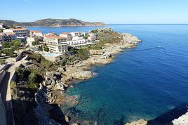
Souhaitant faire de la randonnée sur cette île, je voudrais d'abord savoir quelle serait la période la plus favorable sachant que j'avais passé quelques jours en novembre 2018 pas pour cette activité mais plus pour une simple découverte de l'île et le temps n'était pas top notamment en montagne. Donc peut on choisir une organisation en étoile sachant que je louerai un véhicule avec éventuellement 2 points d'hébergement.
Je n'envisage pas d'intégrer une structure mais de partir à 2 et de s'organiser sauf si vous me conseillez une agence locale ou un guide local. Enfin même si je compte me procurer les différents supports, carte et topo guide plus gps je vous remercie de bien vouloir me communiquer les randos à faire en priorité
Merci beaucoup pour vos informations
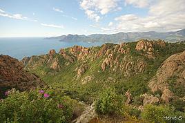
I’m planning to do the Mercantour crossing following the Randoxygène route in mid-July.
I’m used to hiking in the mountains, but I sometimes get vertigo, for example on ridges with drops on both sides. I wanted to check if there are any T4 or T3-T4 sections and find out if there are any very exposed passages—and if so, where—so I can plan an alternative route.
Can anyone give me some info on this?
Thanks!
I’m planning a trip around Cap Corse and the AGRIATES in 2026, from May 8th to 15th (there are still 2 spots left, by the way! Just DM me if you're interested).
I’d love to know which hikes are worth prioritizing in the AGRIATES. We’ll be staying in SALECCIA for two days as our base—what should we focus on from there?
A round trip to IGNHU beach? Any other suggestions?
For Ostricano, I think it’s too far for a round trip...
Thanks for your tips!
Have a great day,
Anie, Toulouse
I’d like to get some info about the GR10 Pyrenees traverse. I need help planning the daily stages and accommodations—my wife isn’t an experienced hiker but walks a lot, so I’d like to schedule shorter walking days and thus a longer overall trip in terms of number of days.
Could anyone give me some help and advice?
Best regards,
New to this forum, I’m planning a pretty big project for 2028.
I’m heading to Nepal to do a trek from Kathmandu all the way to Everest Base Camp (a cool 5,300 m 😄).
This trek is a bit special because even though I’ll be part of a group, I’m going solo (so far, no problem—I’m used to it). But it’s my first real trek, and it’s also a humanitarian one: once I reach base camp, I’ll stay an extra week to help clean up the waste left by tens of thousands of climbers! Since I’m originally from South America, from two countries that share the Andes, I have a deep respect for mountains—they fascinate me. So Everest… it’s kind of the trip of a lifetime!
So, a little question for those who’ve done treks to Everest before… any tips for good mental preparation (I’m already working on the physical side)?
Hi there, I’m planning the Annapurna Circuit for March 2027 and I’m looking for a local agency with a local guide—preferably French-speaking—to arrange this trek for us. Any suggestions? Thanks
Hello!
We’re spending a few days in Toraja country at the end of May. We’d love to do a day trek—taking our time—on a route that’s stunning in terms of scenery, but not a level 5 in difficulty!
Any suggestions you can share, please?
Thanks in advance
I’d like to do the Mare a Mare Sud in May over 4 days. I’ve found quite a few places to stay along the route, but I’m stuck on the start and finish.
I’ll be arriving by plane on Sunday evening and would like to start pretty early on Monday morning. Ideally, accommodation right at the trailhead (Alzu di Gallina) would be amazing, but I can’t find anything. Any tips?
Also, for the transfer from Figari Airport to Porto Vecchio or Alzu di Gallina?
At the end, I’d like to pick up a rental car—any advice on that too?
I’m traveling solo by plane to Catania in May and plan to hike the northern side of Etna, starting from Linguaglossa where I’ll arrive by bus. After that, I’d love some info on how to get up to Piano Provenzana (shuttles or hitchhiking), since it seems there’s no public transport except in the summer. Can you sleep there in a free or cheap refuge, or camp? And how far up can you go without having to hire a guide? Thanks in advance. Bernard.
Bonjour a tous,
je pars en voyage au Maroc en aout et nous allons commencer par nous arrêter a Chefchaouen(nous sommes en voiture).
Ma question: quelqu'un peut il m'indiquer un itinéraire de rando en boucle d'entre 5 et 7 jours aux départ de Chefchaouen dans le parc de Talassemtane passant si possible par le pont de dieux?Ou un guide papier qui en reunis quelques uns?
Nous privilégions le camping sauvage et les gites.
Merci d'avance
Hi there, for those who’ve been recently—is it possible to find other solo travelers in March on the island to share transport or room costs? It doesn’t seem easy to travel on a budget.
If you have any recommendations for simple lodgings or places with dorms, I’d love to hear them.
For those who’ve done multi-day treks while moving around: do you need to bring your own sleeping bag? I’d love to hear about itineraries you’ve done without a guide, just with a map and GPS.
Thanks, and have a great day!
Hi everyone!
We’re planning a 15-day road trip to Scotland this summer, specifically to explore and hike on Lewis and Harris—places we’ve never been before. We’ve visited other islands on previous road trips in Scotland (we usually go in April for a week). This would be our first time in Scotland in the summer and for 15 days. We’re looking at late August to early September.
I’m currently drafting the itinerary. We’d be crossing from Ullapool and were thinking of spending 3 nights on Harris and 4 nights on Lewis.
Does that sound balanced to you? Is it better to keep the same accommodation on Harris and the same on Lewis to explore the area? I’d love to hear about any past experiences you’ve had on these islands.
Thanks!
Hi there, I’m trying to leave for 15 days very soon to São Vicente. I’m either looking to join an agency or figure things out on my own to go hiking on one of these islands or both. From what I’ve seen, it’s not easy to organize with local transport, so it gets expensive. Can I use the services of a small local agency? I’m looking for the simplest way to hike for several days. Also, how do you get from São Vicente to São Nicolau? Thanks in advance and have a great day!
Aichatou
I’ve been wanting to do this for several years, and this year’s the one. Next September, I’ll be trekking in Tusheti (Georgia), from Omalo to Shatili.
Of course, I won’t be renting a vehicle that’d just sit unused. No problem getting to Pshaveli, but from there to Omalo, it’s a dirt road (still the case?)
There must be some form of public transport since there are so many guesthouses, and not all travelers come in a 4x4.
If any of you have been to Omalo, could you confirm that these shared transports exist and how often they run?
we’re planning a trip to Yellowstone and hoping to do a three-day backcountry hike if we get a permit.
if any of you have done this before, could you let me know if it’s possible to find water along the way? And if we can transport it, are we allowed to use a stove?