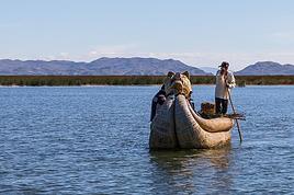
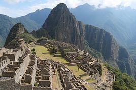
Je pars avec 2 amis faire un trek en autonomie complète au pérou en novembre pour 14 jours (de rando). Arrivée à Cuzco, départ du trek à Cachora. En regardant dans les forums, les trecks les plus longs sont 7 à 8 jours (début cachora fin machu picchu (voir carte en pièce jointe). J'aimerais savoir si certains ont fait un trek plus long. Sur la carte, en passant à Yamana, j'aimerais prendre côté Ouest au lieu de prendre côté Est. Si certains l'ont fait, combien de temps faut il en moyenne en passant à l' Ouest pour rejoindre le machu picchu.
2 ème question... Existe t il une carte avec les "campings" ou lieux autorisés pour planter la tente dans cette région?
Merci pour tous les renseignements que vous pourrez m'apporter.
Je peux répondre partiellement.
Fin J1 rive gauche de l'Apurimac, chez l'habitant mais gratuit en 210
Fin J2 à Choquequirao même (Nous en fait on n'est pas restés et on a enchaîné jusquà fin J3 en une double étape).
Fin J3: Soit chez l'habitant soit sous le col de San Juan si vous poussez plus loin, un peu au dessus des bois.
Fin J4: Nous on avait campé bien au dessus de Yamana, dans un très beau cadre et sur un sol parfait.
Ensuite on avait enchaîné une énorme étape et on avait campé à un bled, Sta Rosa ou la Playa, je ne me souviens plus.
A Yanama, il y a un chemin qui continue sur Huancacalle et les ruines de Vitcos, c'est de la tres bonne rando mais seulement 1 jour et demi. Apres Huancacalle, tu as en effet le long trek aventureux Vilcabamba, cite perdue des incas, je ne l'ai pas fait, tu devras te renseigner sur la securite. Il est decrit dans le guide Trailblazers en Anglais.
Merci Cocuy, c'est justement ce que font la plupart des randonneurs. Nous, nous aimerions passer du côté Ouest comme indiqué sur la carte dans mon premier message. Vu que nous ne savons pas comment cela va se passer, nous prévoyons de transporter notre nourriture, et si nous avons la chance de pouvoir manger chez l'habitant ce sera que du plus!
Merci Willemspie,
C'est justement ce trek dont je parlais Yanama-Huancacalle-Yanatile puis descendre dans le sud en passant par le machu picchu.
De quelle sécurité parles tu? Du trek en lui même ou de la population locale? J'ai regardé sur internet le descriptif du guide du trail blazer, je devrais me débrouiller avec, mais n'existe t il pas un guide en français?
Sur le lien ci-dessous, tu trouveras la trace d'un trek que j'avais fait et qui continue vers Vilcabamba (Espiritu Pampa) et rejoins une piste à partir de laquelle il est possible de rentrer sur Cuzco.
http://www.openrunner.com/index.php?id=2077903
Etienne
Etienne
Il n'y a pas de chemin vers le bonheur, le bonheur c'est le chemin.
"Qui avale une noix de coco fait confiance à son anus" Proverbe africain
http://etienne.fert.pagesperso-orange.fr/
Lorsque j'ai effectué le trek, il n'y avait pas de service de restauration mais des achats d'appoint comme des biscuits, des chips, des sodas ou bière: ça allège quand même et c'est agréable, une boisson sur le chemin ou à la fin de l'étape.
Merci Etienne,
Pour avoir une estimation, en combien de temps as tu fait ce trek?
Richard.
Je ne sais plus, c'était avec une agence donc avec des étapes classiques en km et D+ en altitude pour quelqu'un en forme sans plus. Je pense que c'était plus ou moins en 15 jours. L'essentiel est d'adapter son timing à sa vitesse et à la charge qu'on doit porter. Côté pratique, il était en général possible d'acheter des boissons et snacks le soir dans les hameaux à côté desquels on campait.
Etienne
Etienne
Il n'y a pas de chemin vers le bonheur, le bonheur c'est le chemin.
"Qui avale une noix de coco fait confiance à son anus" Proverbe africain
http://etienne.fert.pagesperso-orange.fr/
Ok, merci pour toutes ces infos, je pense avoir une bonne idée de ce qui nous attend, à nous de décider du chemin maintenant. Il nous restera aussi à voir comment l'altitude joue sur notre physique!
Par l'ouest depuis Yanama, je ne sais pas, mais pour le trek normal allant à La Playa, les deux cols hauts sont:
San Juan (> 4000) avant Yanama et Totora(4600) après, mais ce sont des cheminements très progressifs sans pente raide. Par ailleurs, il est bon de rester à Cuzco, qui est déjà à 3400 m et faire une ou deux balades dans les environs, comme les vestiges archéologiques juste à côté.
Désolé pour cette question opportuniste qui sort du sujet ouvert.
Fin J3: Soit chez l'habitant soit sous le col de San Juan si vous poussez plus loin, un peu au dessus des bois.
Est-ce que cela correspond au site appelé Maizal ?
De que j'ai lu comme retours d'expérience sur Maizal, il semble y avoir 3 sites pour planter sa tente. Sites disposés en V d'après ce que j'ai compris, celui situé vers l'ouest bénéficiant d'un abri (mais ouvert à l'air). Mais je n'avais pas imaginé que l'on pouvait coucher chez l'habitant.
Merci d'avance pour toutes précisions.
Fabrice
S'exposer à l'Etranger lointain amène à mieux connaître et comprendre sa propre Culture.
Notre trek remonte à 5 ans (août 2010).
Les trois premières étapes sont ponctuées par des bivouacs non pas des logements donc.
On met à ta disposition un espace pour ta tente, sur un gazon bien épais.
Ces trois bivouacs se trouvent:
1. Chaquisca sur la Rive gauche de l'Apurimac, 30 mn(ou un peu plus?) avant le pont qui enjambe l'Apurimac.
2. Site du Choquequirao
3. La ferme à 2960 msnm ( Maizal?) : C'est au dessus du rio Blanco (1600 m), à disons 3 h de marche.
A l'époque c'était une indigène parlant un espagnol très mâtiné de quechua qui nous a accueillie.
On a acheté des chips et des sodas puis on est repartis car on avait encore du temps.
Il y avait plein de chiens vautrés sous le soleil, des poules, des canetons ... et aussi un paquet de simulies: manches longues ou répellent efficace contre ce sale moucheron piqueur, qu'on trouve parfois assez haut.
Bien plus haut, après les zones boisées traversées par un sentier très très boueux, et avant le col San Juan (4050 m d'après mon alti), vers les 3800,3900 m, il se trouve plusieurs espaces pour le bivouac, pas énormes mais suffisants. L'un d'eux est près d'un cône caractéristique, dans mon souvenir.
C'est là qu'on a dormi et ça été une belle soirée.
Merci pour ces précisions qui correspondent aux informations que j'ai collectées sur le web.
Mon incompréhension provenait de la formulation "chez l'habitant" que tu as utilisée. Qu'il faut comprendre comme "bivouac chez l'habitant" alors que j'imaginais, étonné, une forme de "homestay".
A mon programme pour l'été 2016, avant arrivée du télécabine du Choquequirao.
Fin de la digression (avec mes excuses pour l'initiateur de cette discussion).
Fabrice
P.S. : pour les simulies, j'ai subi leur piqûre en redescendant le soir du Machu Picchu. Durablement douloureux. Reste à trouver un répulsif efficace. Car les manches longues ne suffisent pas à protéger la tête et les mains.
S'exposer à l'Etranger lointain amène à mieux connaître et comprendre sa propre Culture.
Fais-le savoir si tu trouves un répulsif efficace, en ouvrant carrément un fil dédié au sujet, car en ce qui me concerne, cet insecte est bien pire que le moustique. Dernièrement J'ai bêtement déjeuné une 1/2 heure au bord d'un torrent, et paf! 10,12 "piqûres" à chaque avant-bras. Il y a diverses espèces de simulies: celles-ci ne ressemblaient pas tout à fait aux simulies les plus classiques (gros moucherons bruns ou noirs) avec du blanc sur les ailes, et je ne me suis pas méfié au départ, mais après coup avec le type de boutons très caractéristiques et des démangeaisons durant une semaine, pas de doute sur la famille de l'insecte!
A mon avis, les gens ont muté! Dans une petite ville assez basse (1400 m?) et déjà bien chaude, où on attendait pour rentrer à Cuzco, c'était l'infestation: Ma femme et moi on ne savait plus où se mettre mais les habitants n'avaient pas l'air importunés le moins du monde!
Au Brésil, où on les appelle borrachudos, on étale un corps gras sur la peau, ce qui les empêche de se poser. Bon! c'est pas très commode non plus si on doit s'enduire fréquemment de saindoux! 😉
Pour Huancacalle pas de probleme, il y a une bonne GH. Le trek Vilcabamba Espiritu Pampa part dans la direction opposee au MP, il descend ensuite vers le VRAE, une region tres troublee.
Pour les insectes, le mieux est de se couvrir avec une chemise blanche.
Dans la jungle amazonienne, j'avais passé d'abord plusieurs jours avec un t-shirt manche longue bleu et j'avais été beaucoup piquée (pire avec le pantalon noir malgré son épaisseur). J'ai ensuite acheté une chemise très claire et plus aucune piqure. Je ne sais toujours pas si c'est dû à la couleur ou au tissu. Je pense que quand les insectes nous aiment, il n'y a de toute façon pas grand chose à faire.
"Ils ne savaient pas que c'était impossible, alors ils l'ont fait" (Mark Twain)
Mon blog à propos de simplicité volontaire et de voyage:
Berlin-Cracovie (sept 2013); Thaïlande (juil 2014); Equateur (sept 2014-déc 2014) - Pérou (déc 2014- en cours).
http://deuxpasdecote.wordpress.com/
La Cordillère Vilcabamba est décrite dans le Guide Apacheta.
Pour un trek longue durée, tu peux faire :
Cachora - Yanama - Huancacalle - Yanatile > transport pour le Machu Picchu, puis si t'as encore de l'énergie, rentrer à Cusco par : Hidro - Playa - Salcantay - Mollepata 😉
Je me demandais si certains d'entre vous avait déjà organiser un trecking de quelques jours au Pérou avec de jeunes enfants? Idéalement en basse altitude...…
Nous sommes intéressés pour partir en famille au Pérou cet été et nous souhaiterions faire un trek de 8 jours avec un guide local, avez vous un contact à nous…
Nous sommes un petit groupe (3) et nous envisageons de partir en septembre-octobre 2020 pour deux mois au Pérou et ensuite en Bolivie. Nous aimerions faire…
J'aimerais savoir si il est proposez des excursions, randos ou treks dans l'Ausangate autre que ce qui est toujours proposé (le tour de l'Ausangate)? Ce que…
Je me pose quelques questions sur la possibilité de faire des treks au Pérou sans passer par une agence. En particulier ceux de Huayhuash et de l’Ausangate.…
Hi,
We’re planning to do the 4-day trek from Mestia to Ushguli without an agency. The descriptions mention that there are accommodations at each stop, but we can’t find any details about them. Has anyone got info or feedback on this route?
We're planning to trek in Peru and Bolivia and would love to find some local agencies.
If you know any, could you share details on prices and, of course, the names of the agencies?
Which trek would you recommend?
Elocine
Je pars en autonomie totale sur un trek au Maroc (10jrs) Imilchil - Aghbalou.
Trouve t-on des cartouches gaz à vis (Coleman, Primus) à Marrakech (adresse) ou villages entre Imilchil - Aghbalou ?
Si non , trouve-t-on des cartouches Butagaz pour camping-gaz (petit volume 230 gr ...)
Merci d' avance pour vos réponses
Hello, I’d like to embark on a little trip in my home country, Switzerland. I’ll start walking from La Cure, heading toward Le Noirmont first, then I’ll improvise my route—but it’ll probably follow the French border... at least as far as Lac de Joux.
I’ll decide day by day how much farther to go after that. My goal is to stay in nature as much as possible, wander around for as long as I can, and restock food in villages or towns along the way.
I’m thinking of mostly camping, but we’ll see if I end up in a hotel or another campsite depending on my route.
I’d love to reach La Chaux-de-Fonds on foot... maybe even Delémont.
The whole thing should take about a week, give or take.
I’ll be bringing my dog, and I’m preparing for this as soon as I’m ready.
Any tips to make sure everything goes smoothly for us? Things I should know—or avoid? What about shepherds with their flocks of sheep? And isn’t hunting season open right now?
I’m not sure if what I’m planning is even doable, which is why I’m asking around.
This’ll be my first time doing something like this—wandering in nature *and* with a dog. I’m really excited for this adventure... and I need it. Thanks!
We’re really keen on ecosystems and want to hike in "natural" ancient forests—not planted woods or areas heavily degraded by human activity. Travel guides (like Lonely Planet) don’t provide much info on this. Could you point us to the most interesting spots?
Thanks in advance for your tips.
We wish you happy holidays and a fantastic 2026, full of discoveries!
Claire and Albert
Hi, this might not be the right section, but I’d like to know if it’s possible to start mountaineering with another person without necessarily hiring a guide. We’ve done quite a bit of hiking but not mountaineering—we’ll just do a half-day glacier course. After that, we were thinking of starting with La Grande Motte and the Pointe de la Traversière, which were recommended to us. Honestly, for things like roping up and knots, I’ll learn at home with lots of videos and a book.
Hi,
I don’t know Switzerland at all and was wondering if Vallée des Joux and especially Dent de Vaulion are packed early in the morning or late in the afternoon in July and September?
If so, do you have any quieter spots to recommend in the area, or in Luxembourg (yes, I know it’s not the same country 😉)?
Thanks a lot!
Jaimerais savoir si quelqu'un aurait fait des treks sur le Ruwenzori et combien ça coute en moyenne, les infrastructures, les paysages la sécurité sur les lieux, merci beaucoup. J'attends avec impatience vos réponses.
We’re leaving in 9 days for a two-week trip to Madeira, mainly to hike.
From my research, I’ve found that since last year, access to most trails—and systematically for the most popular ones—is now paid. You have to pay an access fee of 4.50 € per person per classified hike in 2026, and even 10.50 € for the most iconic hike: Pico Arieiro to Pico Ruivo. When paying, you also have to choose a day and a 30-minute time slot for your start time. Of course, this reservation is neither changeable nor refundable, even if the weather that day is terrible.
Personally, given the massive influx of tourists to the island in recent years, I don’t mind paying a fee to help maintain the trails. Similarly, setting a limit on the number of people who can hike them per day is certainly preferable to preserve this priceless heritage.
However, what’s much less fair is that in reality, most of the available spots are reserved: 1/ for Madeira residents (which is normal); 2/ for "economic operators" (meaning local tour operators). For example, if you’re a non-resident (independent tourist), no booking is possible for the Pico Arieiro hike for an early morning start before September! So, unfortunately, we’ll have to skip this hike.
It’s the same issue for Ponta de São Lourenço, the 25 Fontes, Pico Ruivo... in short, all the most popular hikes. Oh well, we’ll skip those too!
So my question is: which hikes do you recommend where we won’t face the huge crowds that the others get? And where we can book the day before for the next day, taking the weather into account?
Finally, a quick accommodation question: we’ve booked the first week in Funchal, but I haven’t decided yet for the second week. Do you have any advice on where to stay in the south or north, preferably avoiding overly concrete-heavy and touristy spots?
I’m reposting about the logistics for Samaria Gorge.
I’d love to get recent info, especially about whether it’s possible to park my car in Omalos, do the hike, and then catch a bus back to my vehicle.
In theory, it’s doable, but when you check the KTEL website, there aren’t any feasible schedules listed. If anyone has recently organized this with reliable, verified details, I’d really appreciate it. Thanks in advance!
Hi there,
We’re flying from Montreal to Lyon this August to go hiking in the French Alps. We’ve rented a car and will be staying at campgrounds. We’re planning to do day hikes and want to stay a few days in one spot, do a few hikes, then move on to our next camping spot. Could you share your favorite spots or any recommendations for places to spend a few days with great hikes?
A few details:
We arrive in early August and leave in early September.
We’re looking for day hikes (or shorter), moderate difficulty, with a cumulative elevation gain of no more than 1000m, and of course, beautiful scenery!
We’d prefer not to drive too much—maybe it’s best not to head too far south and deal with unnecessary heat?
Along the same lines, if you know of any great campgrounds where we can start our hike directly without needing the car, we’d love to hear your suggestions!
Bonjour
Souhaitant faire de la randonnée sur cette île, je voudrais d'abord savoir quelle serait la période la plus favorable sachant que j'avais passé quelques jours en novembre 2018 pas pour cette activité mais plus pour une simple découverte de l'île et le temps n'était pas top notamment en montagne. Donc peut on choisir une organisation en étoile sachant que je louerai un véhicule avec éventuellement 2 points d'hébergement.
Je n'envisage pas d'intégrer une structure mais de partir à 2 et de s'organiser sauf si vous me conseillez une agence locale ou un guide local. Enfin même si je compte me procurer les différents supports, carte et topo guide plus gps je vous remercie de bien vouloir me communiquer les randos à faire en priorité
Merci beaucoup pour vos informations
I’m planning to do the Mercantour crossing following the Randoxygène route in mid-July.
I’m used to hiking in the mountains, but I sometimes get vertigo, for example on ridges with drops on both sides. I wanted to check if there are any T4 or T3-T4 sections and find out if there are any very exposed passages—and if so, where—so I can plan an alternative route.
Can anyone give me some info on this?
Thanks!
I’m planning a trip around Cap Corse and the AGRIATES in 2026, from May 8th to 15th (there are still 2 spots left, by the way! Just DM me if you're interested).
I’d love to know which hikes are worth prioritizing in the AGRIATES. We’ll be staying in SALECCIA for two days as our base—what should we focus on from there?
A round trip to IGNHU beach? Any other suggestions?
For Ostricano, I think it’s too far for a round trip...
Thanks for your tips!
Have a great day,
Anie, Toulouse
I’d like to get some info about the GR10 Pyrenees traverse. I need help planning the daily stages and accommodations—my wife isn’t an experienced hiker but walks a lot, so I’d like to schedule shorter walking days and thus a longer overall trip in terms of number of days.
Could anyone give me some help and advice?
Best regards,
New to this forum, I’m planning a pretty big project for 2028.
I’m heading to Nepal to do a trek from Kathmandu all the way to Everest Base Camp (a cool 5,300 m 😄).
This trek is a bit special because even though I’ll be part of a group, I’m going solo (so far, no problem—I’m used to it). But it’s my first real trek, and it’s also a humanitarian one: once I reach base camp, I’ll stay an extra week to help clean up the waste left by tens of thousands of climbers! Since I’m originally from South America, from two countries that share the Andes, I have a deep respect for mountains—they fascinate me. So Everest… it’s kind of the trip of a lifetime!
So, a little question for those who’ve done treks to Everest before… any tips for good mental preparation (I’m already working on the physical side)?
Hi there, I’m planning the Annapurna Circuit for March 2027 and I’m looking for a local agency with a local guide—preferably French-speaking—to arrange this trek for us. Any suggestions? Thanks
Hello!
We’re spending a few days in Toraja country at the end of May. We’d love to do a day trek—taking our time—on a route that’s stunning in terms of scenery, but not a level 5 in difficulty!
Any suggestions you can share, please?
Thanks in advance
I’d like to do the Mare a Mare Sud in May over 4 days. I’ve found quite a few places to stay along the route, but I’m stuck on the start and finish.
I’ll be arriving by plane on Sunday evening and would like to start pretty early on Monday morning. Ideally, accommodation right at the trailhead (Alzu di Gallina) would be amazing, but I can’t find anything. Any tips?
Also, for the transfer from Figari Airport to Porto Vecchio or Alzu di Gallina?
At the end, I’d like to pick up a rental car—any advice on that too?
I’m traveling solo by plane to Catania in May and plan to hike the northern side of Etna, starting from Linguaglossa where I’ll arrive by bus. After that, I’d love some info on how to get up to Piano Provenzana (shuttles or hitchhiking), since it seems there’s no public transport except in the summer. Can you sleep there in a free or cheap refuge, or camp? And how far up can you go without having to hire a guide? Thanks in advance. Bernard.
Bonjour a tous,
je pars en voyage au Maroc en aout et nous allons commencer par nous arrêter a Chefchaouen(nous sommes en voiture).
Ma question: quelqu'un peut il m'indiquer un itinéraire de rando en boucle d'entre 5 et 7 jours aux départ de Chefchaouen dans le parc de Talassemtane passant si possible par le pont de dieux?Ou un guide papier qui en reunis quelques uns?
Nous privilégions le camping sauvage et les gites.
Merci d'avance
Hi there, for those who’ve been recently—is it possible to find other solo travelers in March on the island to share transport or room costs? It doesn’t seem easy to travel on a budget.
If you have any recommendations for simple lodgings or places with dorms, I’d love to hear them.
For those who’ve done multi-day treks while moving around: do you need to bring your own sleeping bag? I’d love to hear about itineraries you’ve done without a guide, just with a map and GPS.
Thanks, and have a great day!
Hi everyone!
We’re planning a 15-day road trip to Scotland this summer, specifically to explore and hike on Lewis and Harris—places we’ve never been before. We’ve visited other islands on previous road trips in Scotland (we usually go in April for a week). This would be our first time in Scotland in the summer and for 15 days. We’re looking at late August to early September.
I’m currently drafting the itinerary. We’d be crossing from Ullapool and were thinking of spending 3 nights on Harris and 4 nights on Lewis.
Does that sound balanced to you? Is it better to keep the same accommodation on Harris and the same on Lewis to explore the area? I’d love to hear about any past experiences you’ve had on these islands.
Thanks!
Hi there, I’m trying to leave for 15 days very soon to São Vicente. I’m either looking to join an agency or figure things out on my own to go hiking on one of these islands or both. From what I’ve seen, it’s not easy to organize with local transport, so it gets expensive. Can I use the services of a small local agency? I’m looking for the simplest way to hike for several days. Also, how do you get from São Vicente to São Nicolau? Thanks in advance and have a great day!
Aichatou
I’ve been wanting to do this for several years, and this year’s the one. Next September, I’ll be trekking in Tusheti (Georgia), from Omalo to Shatili.
Of course, I won’t be renting a vehicle that’d just sit unused. No problem getting to Pshaveli, but from there to Omalo, it’s a dirt road (still the case?)
There must be some form of public transport since there are so many guesthouses, and not all travelers come in a 4x4.
If any of you have been to Omalo, could you confirm that these shared transports exist and how often they run?
we’re planning a trip to Yellowstone and hoping to do a three-day backcountry hike if we get a permit.
if any of you have done this before, could you let me know if it’s possible to find water along the way? And if we can transport it, are we allowed to use a stove?
Hello,
I’ll be in Nepal from March 6th to 29th (we’re flying into Kathmandu via Varanasi and leaving via Delhi).
I’m a bit confused about the regulations requiring a guide.
My wife and I (we’re 63 and 64) aren’t experienced trekkers—we’re more used to walking on terrain with very moderate elevation changes. I’m looking for fairly easy hikes, possibly day trips.
Here are my questions:
- Does the Poon Hill trek from Pokhara require a guide, or is it better to go through a local agency? (I’ve seen a lot of them offering 4-day packages)
- I’d like to do a few multi-day hikes around Jomsom (Kagbeni, Mukitinath, Lupra, Marpha)... Do you need a guide for those, and can you find accommodations easily without booking in advance?
Last question—I’m really hesitant to lug around a sleeping bag or down jacket during our 6 weeks in India. Can you easily find these kinds of items at reasonable prices in Pokhara?
Thanks in advance for any tips you can share!
Yann