Hi there,
I’d like to know if anyone has already applied for a private visa to Russia with an invitation from a Russian resident.
I traveled earlier this year with an e-visa, but since I want to stay longer, I’ll be visiting my friend who lives in eastern Russia.
For the visa application, does the invitation need to be on an official paper form issued by the Russian ministry? And most importantly, do I need to present the original for the application, or is there an electronic version that can be sent directly to the consulate in France?
Thanks for any info if you’ve gone through this process before!
Best regards,
Gilles
144 similar discussions in English
Hi there,
I’m currently in Hoi An—I hadn’t set foot here for 8 years. The city has already changed a lot, with lots of construction, and even in the old town, along one side of the riverbank, there are huge residential buildings going up that take away some of the charm of this place. But the worst part is the overtourism—it’s impossible to walk across the famous bridge in the middle of the canal in the evening because it’s so packed with people. There’s also a new trend: massage parlors have opened in the old town and around the city. I was shocked—people call out to you or even grab your arm on the sidewalk, and it’s everywhere. Bangkok and Phuket might start shaking—Hanoi’s the same way.
Anyway, let’s talk about the dual pricing specifically for non-Vietnamese tourists. We went to a restaurant near our hotel last night, and they gave us an English menu—okay, fine! But I noticed the table next to us, where Vietnamese tourists had a different menu. Weird! I asked to see the same menu as my neighbors, but the waitress refused, saying it was in Vietnamese and we wouldn’t understand. I insisted, and she finally agreed. Surprise!!! The prices on the two menus were different, with the English one up to 50% more expensive. I asked why, and she got flustered, telling me to just order from the Vietnamese menu, which I translated with my phone to see the local prices. I mentioned this to the hotel this morning, and the receptionist told me to go to restaurants where prices are displayed at the entrance to avoid getting ripped off. I just bought fresh bread this morning, and it was the same thing—the little loaf costs 4000 dong for Vietnamese people and 5000 dong for non-Vietnamese. It’s not a huge difference, but this way of doing things isn’t right. At supermarkets like VinMart+, prices are displayed, so there’s no surprise or dual pricing there.
We just got back from a trip to Egypt: 2 days in Cairo, then a week on the Nile with a cruise through a tour operator.
An incredible discovery of the Pyramids of Cairo—such an emotional moment! Then a wonderful stroll along the Nile, where we leisurely soaked in the "life" along this river.
An exceptional guide who transported us back less than 4,000–5,000 years BC...
But here’s the thing—because there’s often a "BUT"—the flip side is discovering a *very* polluted country! Even on the Nile, the number of boats is staggering (I went barefoot on the boat one day, and by the end of the day, my feet were black with soot?).
In Cairo, with nearly 20 million inhabitants, there’s trash everywhere (except around the airport and villa areas). We even saw a dead cow with stray dogs eating its "innards"—but no one seemed bothered! By the way, there are *tons* of wild dogs in Egypt and very few... cats!
One day after our arrival, we had to pay our entry visa to the guide on the bus—and *only* in cash? 95 EUROS???? A disgrace, since the visa price is $25 (as stated on the visa stamp)... Someone needs to explain where that money goes???
The excursions (optional ones) are *five times* more expensive than the posted rates for tourists. There are two prices: one for Egyptians (which makes sense, given an average salary of 360 euros/month). On top of that, the cruise manager asked us to pay half in cash and half by card (we refused and paid everything in cash). First time I’ve ever seen that payment method for excursions—where *does* the money go?...
During a stop in Aswan, we wanted to visit the Nubian Museum (amazing!). We took a carriage, and before leaving, we agreed on a round-trip price of 20 euros for 4 people to take us to the museum. It was all good with the driver—who called himself "Michel" and his poor horse, Rambo. On the way back, of course, he caused a scene, demanding *much* more... We refused and gave him the 20 euros we’d agreed on. But then, as if by chance, this same carriage driver stopped for a man who asked us to exchange two 20-euro bills and 10 one-euro coins for a 50-euro bill. I pulled out my 50-euro note while talking to Michel, and the other guy claimed I’d given him a 10-euro bill?? He handed me the bill—so you get the scam!
So, be *very* careful with carriage drivers and their "colleagues"!
Drinks on board are outrageously priced—a simple beer (Stella) costs 5 euros, and the wine is undrinkable...
Tips are expected in euros—they won’t accept Egyptian pounds... and of course, you’re constantly harassed to exchange 5-euro or 10-euro bills, or even more! They end up with tons of coins, so we did it at first, but after a while, it’s just not possible—they insist way too much!
I’ll stop here—it’s already quite long. So, a mixed-feelings trip overall...
philippe
philippe
Hotel La suerte loca in Sidi Ifni.
Move along quickly!
LIAR AND DISHONEST.
Not to mention the state of the rooms. That’ll come later.
I booked three nights on-site without a bathroom in room (No. 16). I had called the day before to check availability. The next day, they told me I couldn’t stay in that room on the third night but offered to move me to another room—even more run-down than this one—and without a bathroom. They claimed there had been a mistake and the room was already booked, which is completely false. I’ve been traveling for 20 years and can spot hoteliers’ tricks. The woman running the place checked all her online sites and her schedule before confirming the room was available. She was sure. Especially since they display the booking schedule in front of each room to avoid mistakes. So, a pure lie. For what reason?
For me, two options: either take the run-down room for cheaper without a bathroom or leave. Great customer service. I found another hotel, Safa, a bit further away, at the same price with breakfast—100 times more luxurious and comfortable than this place. Or just down on the beach, Hotel Aït Baamrane, same price or even negotiable, and still much more comfortable.
When I left in the morning, they barely said goodbye, not a word of apology, no gesture to make up for kicking me out. NOTHING, NADA!
The woman running the place, with her fake friendliness and hypocrisy, only cares about one thing: money.
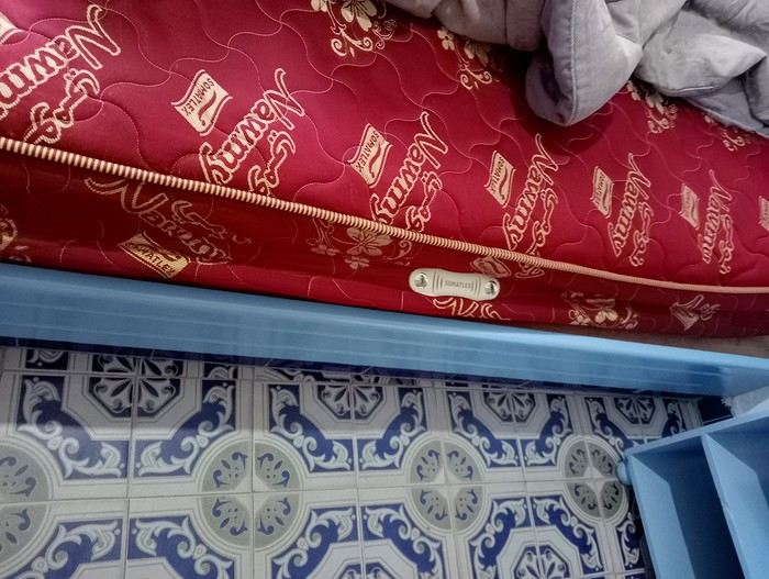
Otherwise, the place could be great if it were properly maintained. Instead of repainting the balconies, they should replace the mattresses, which are completely wrecked. The only good thing about this hotel is its location above the sea.
Otherwise, Room No. 16 was recently repainted. Every time someone uses the water, there’s a huge noise from the pipes and vibrations. The walls are paper-thin (figuratively speaking)—when neighbors talked or coughed, it was like they were in the room with me.
I had to wait to check in because of cleaning, but once inside, the bedside tables and the table were filthy (see photo). In the bathroom, there’s a stale smell of old urine and sewage due to the worn-out toilet pipes (see photo), with minimal lighting. The showerhead is disgustingly dirty. The gray duvet is dirty and very old, as are the blankets, which are dusty and grimy. The Wi-Fi worked in the room the first day but not the next.
And finally, the worst part: the mattress is completely wrecked and sagging. The springs dig into your body. Horrible! Instead of repainting, they’d do better to change the mattresses.
As for meals, the prices are outrageous. This hotel relies on its old popularity, but it’s not worth 190 dirhams for this room. I’d say it’s barely worth over 100 dirhams. Since I’ve been in Morocco, I’ve stayed in palaces for 130 dirhams with breakfast.
So, my advice: don’t trust the reviews and avoid this place. You’ll find much better at the same price, as mentioned above.

I booked three nights on-site without a bathroom in room (No. 16). I had called the day before to check availability. The next day, they told me I couldn’t stay in that room on the third night but offered to move me to another room—even more run-down than this one—and without a bathroom. They claimed there had been a mistake and the room was already booked, which is completely false. I’ve been traveling for 20 years and can spot hoteliers’ tricks. The woman running the place checked all her online sites and her schedule before confirming the room was available. She was sure. Especially since they display the booking schedule in front of each room to avoid mistakes. So, a pure lie. For what reason?
For me, two options: either take the run-down room for cheaper without a bathroom or leave. Great customer service. I found another hotel, Safa, a bit further away, at the same price with breakfast—100 times more luxurious and comfortable than this place. Or just down on the beach, Hotel Aït Baamrane, same price or even negotiable, and still much more comfortable.
When I left in the morning, they barely said goodbye, not a word of apology, no gesture to make up for kicking me out. NOTHING, NADA!
The woman running the place, with her fake friendliness and hypocrisy, only cares about one thing: money.
Otherwise, the place could be great if it were properly maintained. Instead of repainting the balconies, they should replace the mattresses, which are completely wrecked. The only good thing about this hotel is its location above the sea.
Otherwise, Room No. 16 was recently repainted. Every time someone uses the water, there’s a huge noise from the pipes and vibrations. The walls are paper-thin (figuratively speaking)—when neighbors talked or coughed, it was like they were in the room with me.
I had to wait to check in because of cleaning, but once inside, the bedside tables and the table were filthy (see photo). In the bathroom, there’s a stale smell of old urine and sewage due to the worn-out toilet pipes (see photo), with minimal lighting. The showerhead is disgustingly dirty. The gray duvet is dirty and very old, as are the blankets, which are dusty and grimy. The Wi-Fi worked in the room the first day but not the next.
And finally, the worst part: the mattress is completely wrecked and sagging. The springs dig into your body. Horrible! Instead of repainting, they’d do better to change the mattresses.
As for meals, the prices are outrageous. This hotel relies on its old popularity, but it’s not worth 190 dirhams for this room. I’d say it’s barely worth over 100 dirhams. Since I’ve been in Morocco, I’ve stayed in palaces for 130 dirhams with breakfast.
So, my advice: don’t trust the reviews and avoid this place. You’ll find much better at the same price, as mentioned above.
Hi everyone,
What a joy to be back here and pick up where we left off after all these months of hiatus.
I hope you’ll enjoy the story of this little trip around the Eastern Mediterranean. This cruise was the perfect way to satisfy our longing to return to Greece and Istanbul. The end of the season, until late November, is the best time to visit the Mediterranean in my opinion—when climate disruptions don’t get in the way.
Departing from Trieste, our stops were Katakolon, Piraeus, Kusadasi, Istanbul, Corfu, and Bari, before returning to Trieste and then Venice, where we planned a very short 24-hour stay.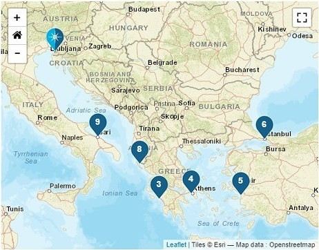
We left home at 6:15 AM—our first cruise departure since moving to Normandy. What I miss most about living in the Gard is how close we were to Marseille Airport. No more hopping over to Marignane in an hour; now we have to plan for a three-hour trip to CDG, even under the best conditions on an early Sunday morning.
It was impossible to book a hotel night before our flight because, starting in April, the Ibis was priced at 450 € per night, and the Mercure was flirting with 800 €—breakfast not included, of course. 😏
I had a feeling there must’ve been a conference or something going on… Turns out, it was just the auto show. They simply adjusted the room prices to match the cost of the cars. 😛
Our flight took us to Venice, where we caught a FlixBus to Trieste. We arrived at Trieste’s train station in the afternoon and walked to our hotel in the city center.
After treating ourselves to an amazing pizza at a restaurant (Di Napoli Maestri Pizzaioli, Via Armando Diaz 10) for a very reasonable price, we enjoyed the mild evening temperature while exploring the stunning buildings of this charming city by night. These magnificent structures are a testament to the city’s past. Trieste became Austrian in 1382 due to its complicated relationship with Venice, and it wasn’t until 1918, at the end of World War I, that it became Italian again. The city’s lighting beautifully highlights the architecture of the buildings.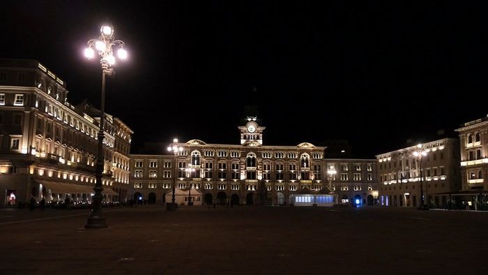
The terraces were lively, and the atmosphere was so warm and inviting that we wanted to stay out even longer.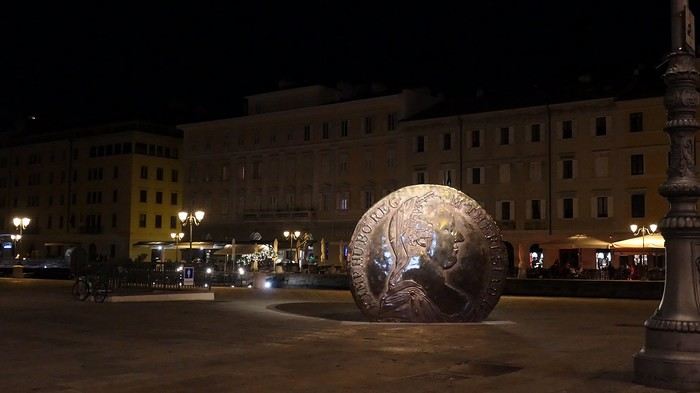
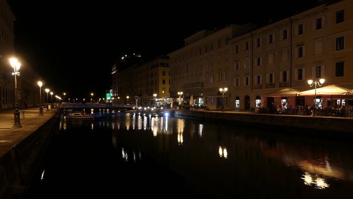
But we’d been up since 4 AM, so we were happy to retreat to the quiet of our hotel, located in the pedestrian center just a few steps from the port (Urban Hotel Design—highly recommended).
More to come soon.
What a joy to be back here and pick up where we left off after all these months of hiatus.
I hope you’ll enjoy the story of this little trip around the Eastern Mediterranean. This cruise was the perfect way to satisfy our longing to return to Greece and Istanbul. The end of the season, until late November, is the best time to visit the Mediterranean in my opinion—when climate disruptions don’t get in the way.
Departing from Trieste, our stops were Katakolon, Piraeus, Kusadasi, Istanbul, Corfu, and Bari, before returning to Trieste and then Venice, where we planned a very short 24-hour stay.
We left home at 6:15 AM—our first cruise departure since moving to Normandy. What I miss most about living in the Gard is how close we were to Marseille Airport. No more hopping over to Marignane in an hour; now we have to plan for a three-hour trip to CDG, even under the best conditions on an early Sunday morning.
It was impossible to book a hotel night before our flight because, starting in April, the Ibis was priced at 450 € per night, and the Mercure was flirting with 800 €—breakfast not included, of course. 😏
I had a feeling there must’ve been a conference or something going on… Turns out, it was just the auto show. They simply adjusted the room prices to match the cost of the cars. 😛
Our flight took us to Venice, where we caught a FlixBus to Trieste. We arrived at Trieste’s train station in the afternoon and walked to our hotel in the city center.
After treating ourselves to an amazing pizza at a restaurant (Di Napoli Maestri Pizzaioli, Via Armando Diaz 10) for a very reasonable price, we enjoyed the mild evening temperature while exploring the stunning buildings of this charming city by night. These magnificent structures are a testament to the city’s past. Trieste became Austrian in 1382 due to its complicated relationship with Venice, and it wasn’t until 1918, at the end of World War I, that it became Italian again. The city’s lighting beautifully highlights the architecture of the buildings.
The terraces were lively, and the atmosphere was so warm and inviting that we wanted to stay out even longer.
But we’d been up since 4 AM, so we were happy to retreat to the quiet of our hotel, located in the pedestrian center just a few steps from the port (Urban Hotel Design—highly recommended).
More to come soon.
Good evening everyone,
I hope you're all doing well despite this very unusual time…
Here’s a new travel journal to get you back on the Kenyan trails.
It was a really great idea to buy those flight tickets to Nairobi back in December. When Benoit suggested this new safari in February, I hesitated a little (very little): it was the season with particularly high temperatures, and the short rainy season in November/December had been very heavy, raising concerns about the state of the tracks… Given the current situation, no regrets, of course… We quickly organized the safari with our usual guide, and we booked the accommodations ourselves directly. (If we’d waited just a few more weeks, we might’ve regretted it…)
For once, we were able to leave from the airport near where we live (Lorient - Lann Bihoué), which is really convenient: no driving, no parking… We left home at 2 PM on Tuesday, February 18th, and arrived in Nairobi at 6 AM the next morning—perfect. (With a layover in CDG, of course 😉) Upon arrival, after a forehead temperature check by airport staff, we got our visas very quickly (forms filled out before departure). The customs agents congratulated us on our passports full of Kenyan stamps… but we still had to pay the 40 € for the visa.
All that was left was to collect our luggage, and we’d be ready to leave the airport shortly after landing. But there was a small issue: the baggage conveyor belt was broken… Eventually, the suitcases and bags were brought out by hand… Hakuna Matata, as they say here—no problem, as long as they’re all there. Benoit sent a message to Félix, our guide, to come meet us in the airport parking lot. After catching up with our respective families, we set off toward the Mombasa road, heading to Voi.
Traffic in Nairobi is still as heavy as ever, and the pollution is very noticeable (cars, but also cement factories…). The current lockdown has changed things. On social media, Mount Kenya and Kilimanjaro seem visible from Nairobi now!…
The first stop on this safari was a place we hadn’t visited before: the LUMO Community Wildlife Conservancy lumoconservancy.com/. It’s a small reserve located west of Tsavo West and near the Taita Hills. The reserve is managed by the local community, and entry fees are lower than in Tsavo’s national parks. We had initially planned to spend three days in Tsavo East, but since the accommodation wasn’t available for that long, we ended up choosing this option, which turned out to be a great discovery. Since the reserve is small, I think it’s hard to spend more than two days there. The advantage is that, since it’s not a national park, activities like walks or night safaris can be offered.
Alright, here are a few images to set the mood.
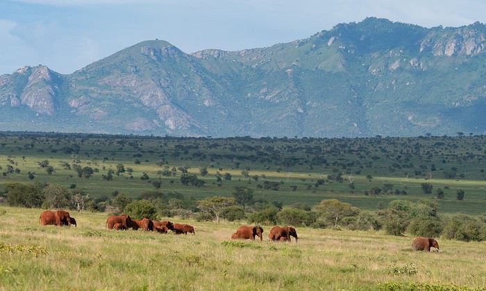
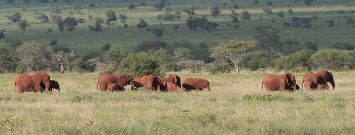
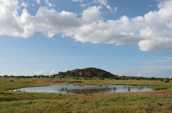
Elephants, but also hartebeests and lots of giraffes in a light we really liked.
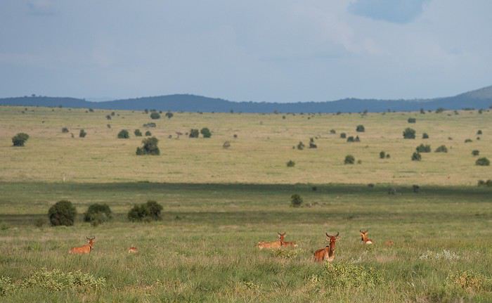
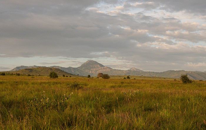
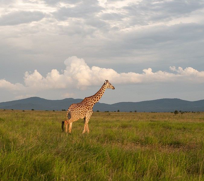
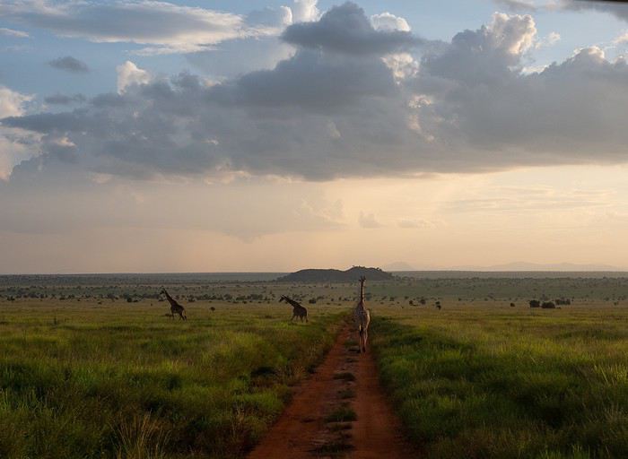
It was a really great idea to buy those flight tickets to Nairobi back in December. When Benoit suggested this new safari in February, I hesitated a little (very little): it was the season with particularly high temperatures, and the short rainy season in November/December had been very heavy, raising concerns about the state of the tracks… Given the current situation, no regrets, of course… We quickly organized the safari with our usual guide, and we booked the accommodations ourselves directly. (If we’d waited just a few more weeks, we might’ve regretted it…)
For once, we were able to leave from the airport near where we live (Lorient - Lann Bihoué), which is really convenient: no driving, no parking… We left home at 2 PM on Tuesday, February 18th, and arrived in Nairobi at 6 AM the next morning—perfect. (With a layover in CDG, of course 😉) Upon arrival, after a forehead temperature check by airport staff, we got our visas very quickly (forms filled out before departure). The customs agents congratulated us on our passports full of Kenyan stamps… but we still had to pay the 40 € for the visa.
All that was left was to collect our luggage, and we’d be ready to leave the airport shortly after landing. But there was a small issue: the baggage conveyor belt was broken… Eventually, the suitcases and bags were brought out by hand… Hakuna Matata, as they say here—no problem, as long as they’re all there. Benoit sent a message to Félix, our guide, to come meet us in the airport parking lot. After catching up with our respective families, we set off toward the Mombasa road, heading to Voi.
Traffic in Nairobi is still as heavy as ever, and the pollution is very noticeable (cars, but also cement factories…). The current lockdown has changed things. On social media, Mount Kenya and Kilimanjaro seem visible from Nairobi now!…
The first stop on this safari was a place we hadn’t visited before: the LUMO Community Wildlife Conservancy lumoconservancy.com/. It’s a small reserve located west of Tsavo West and near the Taita Hills. The reserve is managed by the local community, and entry fees are lower than in Tsavo’s national parks. We had initially planned to spend three days in Tsavo East, but since the accommodation wasn’t available for that long, we ended up choosing this option, which turned out to be a great discovery. Since the reserve is small, I think it’s hard to spend more than two days there. The advantage is that, since it’s not a national park, activities like walks or night safaris can be offered.
Alright, here are a few images to set the mood.
Elephants, but also hartebeests and lots of giraffes in a light we really liked.
Well, since the lockdown is dragging on, I’m starting a new travel journal following the one I finished publishing yesterday:
https://voyageforum.com/discussion/voyage-pays-perles-voyage-dans-ouest-americain-d9943984/
This time, after the U.S., we’re heading to the Middle East—Jordan!
And we’re keeping up the good habits: one day’s entry published every day at 5:30 PM! Happy reading, and feel free to leave a comment, question, or remark...
Franck
Franck
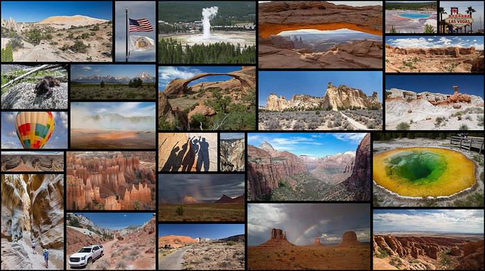
Nine Bretons in the USA from June 24 to July 20, 2018: Greenery and mosquitoes in the North, heat and storms in the South
Choosing the trip:
After returning from the USA in 2014 (travel journal here), it was clear we’d go back, this time with the firm intention of bringing our kids. 😇
2015 was the year of Scotland (travel journal here), 2016 was a work year, and 2017 was the discovery of Aragon in Spain (travel journal here)… Meanwhile, our kids’ age still seemed like a hurdle for this kind of trip. The long wait turned out to be an advantage, letting us refine the project and rally others: what started as a two-week trip for four turned into three weeks for nine!! JF’s parents (M&P, who’d already been in 2014) and JF’s brother (C&D&Y) joined our little family (C&JF&A&L)!!😎 After plenty of family discussions, route tweaks, travel journal reads, and advice from VF (plus some specialized books like Photographing the Southwest by Laurent Martrès), we made up our minds—fully aware of the constraints—and split the trip in two:
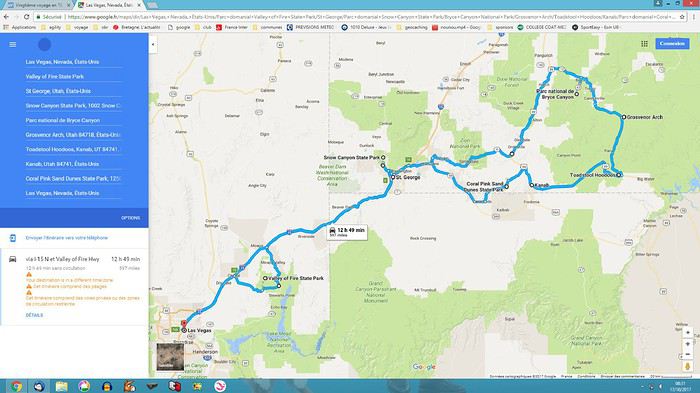
- First week, just the four of us in an SUV + hotels, looping from LV (Valley of Fire, Saint George, Bryce, Kanab), focusing on rocky, sandy, and colorful hikes:
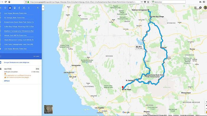
 - Followed by two weeks with nine people in 2 RVs + campgrounds, as close to nature as possible in the parks (Snow Canyon, Kodachrome, Yellowstone, Arches, Canyonlands, Dead Horse, Monument Valley, Grand Canyon):
 🙂Before going further, we want to thank the forum members who took the time to answer our questions. Your patience and kindness are amazing! We might forget someone, but thank you all: Jpg13, Mlefebvre, Kast13,Glll2012New, PCecile, Aquilegia, Adumas4, Ju45, Mycovtt, Natb72, Soula1, Orionide, Simonic, Hiacinthe, etc.
Traveling with nine people (ages 9 to 76, including three kids!!) requires some serious logistics and near-perfect timing to avoid wasting time. The plan went off without a hitch😎… well, almost—we’ll get into the details later…😛🏴☠️🙂 In the end, we came back enchanted and happy!! 🙂The family aspect played a big part, but we also discovered spots that were much less crowded, definitely less known to the general public and the hordes of Asian tourists… The kids returned with stars in their eyes, and the adults with just as many memories (plus around 1,200 photos and 130 GB of GoPro video to sort through)!!😎 We’re already feeling the itch to go back—a Denver loop is starting to take shape…😇
Thoughts on the Americans we met and places we visited: They haven’t changed since 2014… Still cool, optimistic, and smiling, always ready to strike up a conversation and offer help—even without the lure of our tourist dollars. (Only two cold locals at Monument Valley clearly made little effort to help us.) We noticed a few changes in the parks😕: some infrastructure was less well-maintained (wobbly wooden walkways, for example), French info pamphlets disappeared from entrance huts, and there were fewer rangers (Lee’s Ferry ranger station was closed). These changes are likely due to Trump’s restrictive policies toward national parks. On the economic side, gas prices rose by 30% since 2014, now around 0.85 € per liter, and with the current exchange rate, conditions are much less favorable for European tourists than in 2014. But this area is so beautiful—too bad Americans have such an idiot for a president!😠
The flights: Round-trip Paris CDG to Las Vegas LAS Roissy to Los Angeles with Air Tahiti Nui, then American Airlines for Los Angeles to Las Vegas. The A340s were impeccable, and service was great with Air Tahiti Nui (the tiare flower given at boarding), and no complaints about AA either.🙂
The hotels: All booked in advance, either through Hotels.com or directly on the hotel’s website (like the Planet Hollywood in Las Vegas). No surprises, everything met expectations.🙂 It’s a real plus for a family of four to have two beds in every room… Still rare in France.
The campgrounds: Except for one night at Lee’s Ferry, all were booked from France through NPS, Xanterra, and KOA sites. No surprises here either—everything met expectations and was well-organized (fire rings and tables at every site, for example).🙂
The vehicles:
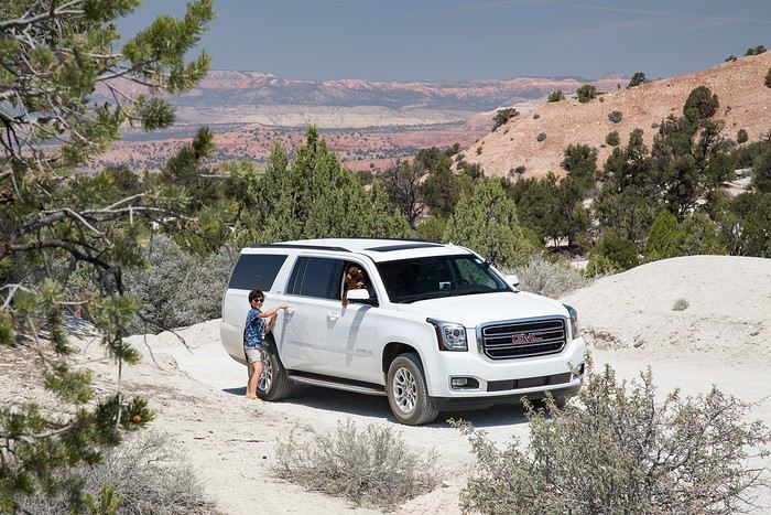
First week: Four people in a GMC Yukon XL from HERTZ, at Las Vegas airport for 327 €, unlimited miles, second driver, and insurance. A typically American beast—355 hp, seven seats: it’s long, big, wide, and tall😮😎😎!! Impeccable condition, quiet, super comfortable with tons of safety features and gadgets (like weather updates tied to GPS!!), and it averaged about 12 L/100 km in 2WD (in 4WD, we nearly hit 19 L on the Stukumpah Road…). A total win thanks to the HERTZ GOLD card, following Jpg13’s advice (Jean-Pierre, you’re my idol!!😎). It let us skip the counter lines (we didn’t even stop there!), pick up the car, and leave the parking lot in under seven minutes… Even less time for the return!
 Second and third weeks: Nine people in two RVs. A 30-foot RV + a 25-foot RV from CRUISE AMERICA in Las Vegas for 5000 €, unlimited miles, kitchenware, and linens/towels/comforters.
A love story in 2014 with this same agency, but unfortunately, this year was much more mixed: aging RVs, ineffective AC in the C30, a leak in the C25’s skylight, a leak in the C25’s toilet drain valve (imagine the dump every time we opened the drain plug…😠🙁), late delivery of both RVs (after 5 PM, though the contract said 4 PM max), abnormal wear on the front tires (we’d discover that later😠), trouble closing the door, etc.In short, a disappointment.😠
Note that other rental companies (El Monte and Road Bear) are probably gaining market share—we saw a lot of their vehicles on the road, and they offer much newer models (at least on the outside) for similar prices…🙂
But setting aside those issues, the vehicles still did their job: letting us sleep as close to nature as possible in the parks and enjoy beautiful sunrises/sunsets with family campfires and marshmallows flambéed with Jack Daniel’s Tennessee Honey😇!!😎 Also worth noting: Cruise America’s solid roadside assistance (we’ll talk more about that later), and how easy it was to drive these beasts—nearly 10 meters long! (Our walkie-talkies were super handy for communication between the two RVs.)
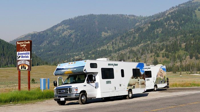 And for the last day, a Ford Transit 12-seater from Hertz, at Las Vegas airport for 145 € for 24 hours. Perfect for a day with nine people and nine suitcases + nine bags!! Everything fit in the trunk, and it let us explore LV independently (including a trip to the outlet) for less than three taxis would’ve cost…😎
There you have it—the scene is set! If you’re interested in the rest, feel free to join in. The travel journal is done on the computer, and we’re up to day 11 for photos… We should be posting daily!!🙂
See you soon. Christelle & JF
After the wide-open spaces of the American West, we're off to a new destination: Dubai. Not just for a layover, but for a real family vacation!! The question that kept coming up was "why Dubai?" (after why Colorado this summer, people are going to think we're really weird 😅). So, why Dubai? First, because skiing isn’t really our thing anymore—so in winter, we want sunshine 😎. But not just any sunshine—warm enough to swim, which narrows things down a bit 😅. The second constraint this year: Franck can’t take more than a week off (and it’s unpaid), so we’re ruling out destinations with 12-hour flights and jet lag that knocks you out when you get back 😅. The options are getting tighter… So, against all odds, it’s me who ends up suggesting Dubai (my husband’s been nagging me for years about Atlantis and its mega water park—ah, the kids! 😉).
Actually, Dubai only has 2 days of rain a year (you’d have to be *really* unlucky!!), temperatures around 30°C in winter, the sea (oh yeah, I forgot—the sea was something we missed this summer, so it was on our list 😅), a 6/7-hour flight, just 3 hours of jet lag, reasonable family prices, and tons of activities for all tastes. Starting my research with a pretty negative bias, I’m now looking forward to this trip with excitement and impatience… and without spoiling the ending, I won’t be disappointed—our whole family will come back enthusiastic and ready to go back!!
So, I’m taking you along for a week in Dubai at the beginning of March.
Hi everyone,
Since I had a fantastic week in Puglia, and it's such a nearby and easily accessible destination from France,
I invite you to check out the article I wrote about it on my blog: www.philippebasset.com/puglia.html
I highly recommend visiting this coastal region along the Adriatic Sea for so many reasons: diverse landscapes, refined and varied cuisine, a very pleasant climate, a discreet and welcoming population, no mafia (it’s sad to say, but many Italian cities are plagued by this scourge, which brings insecurity, filth, and extortion...), and apart from July-August, there’s no risk of mass tourism!
*Dolce vita* guaranteed!
I’m happy to help if you’d like tips or recommendations :)


And plenty more photos to discover—hopefully, it’ll make you want to book a flight to Bari!
Since I had a fantastic week in Puglia, and it's such a nearby and easily accessible destination from France,
I invite you to check out the article I wrote about it on my blog: www.philippebasset.com/puglia.html
I highly recommend visiting this coastal region along the Adriatic Sea for so many reasons: diverse landscapes, refined and varied cuisine, a very pleasant climate, a discreet and welcoming population, no mafia (it’s sad to say, but many Italian cities are plagued by this scourge, which brings insecurity, filth, and extortion...), and apart from July-August, there’s no risk of mass tourism!
*Dolce vita* guaranteed!
I’m happy to help if you’d like tips or recommendations :)
And plenty more photos to discover—hopefully, it’ll make you want to book a flight to Bari!
Since last year, the unification of the Russian visa with Belarus has been in effect.
For reference, EU citizens haven’t needed a visa for Belarus for two years. However, it wasn’t possible to travel to Russia. Only Belarusian and Russian citizens could move freely within the union.
With the unified system, if you enter one of the two countries with a visa from either, you can now travel between them freely.
In the case of a Russian visa, it must be a paper visa glued into your passport—not an electronic visa.
This opens up the possibility of traveling to Russia from Lithuania via Minsk, for example, starting from Vilnius.
It also allows for travel circuits that would otherwise be difficult, despite the proximity of the cities.
So, I’m leaving on June 12th for Vilnius. A one-hour flight for around thirty euros with a carry-on bag, and from Vilnius Airport, there’s a bus to Minsk. My planned route for now is Vilnius-Minsk-Smolensk-Vitebsk-Polotsk-Pskov-Riga.
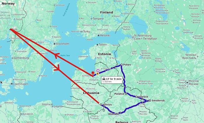
This crosses the Belarus-Russia border three times: from Minsk to Smolensk, then from Smolensk to Vitebsk, and finally from Polotsk to Pskov.
The region of this itinerary was, a thousand years ago, essentially that of the Krivichs, a local Slavic political entity. The term comes from "blood," *krew* in Polish, *krov* in Russian—basically "blood brothers." In Latvian, the word for Russians is *krievu*, by the way. Historically, the region corresponds to some of the old Russian principalities. Later, what marks Belarusian regions in general is, after the Great Schism of 1054, the division between Catholic and Orthodox zones, particularly as the Polish-Lithuanian Commonwealth expanded and contracted. In architecture, this corresponds to variations in Baroque styles, for example.
Vitebsk is known in France as the birthplace of Chagall. Born Russian, he first trained at the art school in Vitebsk, which was also attended by Malevich and Lissitzky, before completing his studies in Saint Petersburg, then moving to Berlin and later Paris. In Paris, Chagall met Cendrars, who had spent three years in Russia before and spoke enough Russian to help the newcomer get by a bit.
Back to the practical travel aspects: a local Pskov newspaper mentions that the Russian and Belarusian governments have a project for a Pskov-Polotsk train line. Previously, there were also plans for lines between Veliky Luki and Vitebsk, and Polotsk. A recently launched railway is Smolensk-Vitebsk, shown in white on the map, with projected lines in blue. https://pln-pskov.ru/society/583817.html https://pln-pskov.ru/society/578335.html
These will likely be "Hirondelle"—that is, *Lastochka*—the fast, spacious regional trains in Russia. Currently, all of this is done by bus, so the train is a very appealing and comfortable option. We’ll see how it goes.
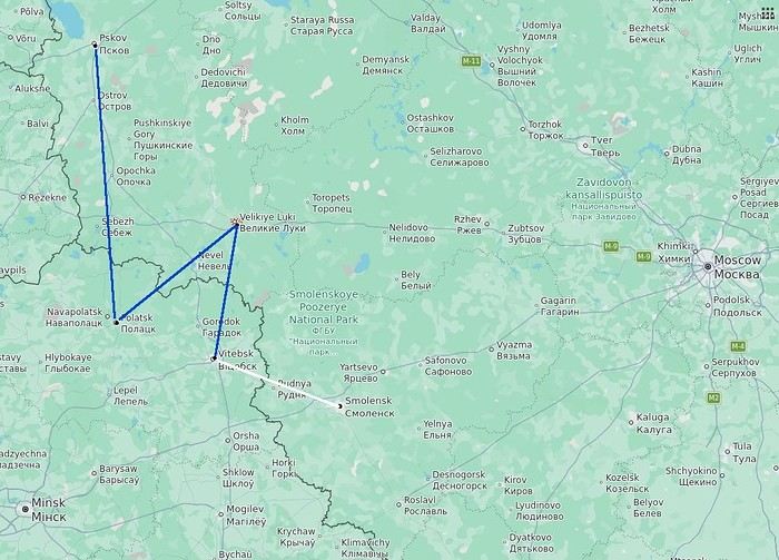
With the unified system, if you enter one of the two countries with a visa from either, you can now travel between them freely.
In the case of a Russian visa, it must be a paper visa glued into your passport—not an electronic visa.
This opens up the possibility of traveling to Russia from Lithuania via Minsk, for example, starting from Vilnius.
It also allows for travel circuits that would otherwise be difficult, despite the proximity of the cities.
So, I’m leaving on June 12th for Vilnius. A one-hour flight for around thirty euros with a carry-on bag, and from Vilnius Airport, there’s a bus to Minsk. My planned route for now is Vilnius-Minsk-Smolensk-Vitebsk-Polotsk-Pskov-Riga.
This crosses the Belarus-Russia border three times: from Minsk to Smolensk, then from Smolensk to Vitebsk, and finally from Polotsk to Pskov.
The region of this itinerary was, a thousand years ago, essentially that of the Krivichs, a local Slavic political entity. The term comes from "blood," *krew* in Polish, *krov* in Russian—basically "blood brothers." In Latvian, the word for Russians is *krievu*, by the way. Historically, the region corresponds to some of the old Russian principalities. Later, what marks Belarusian regions in general is, after the Great Schism of 1054, the division between Catholic and Orthodox zones, particularly as the Polish-Lithuanian Commonwealth expanded and contracted. In architecture, this corresponds to variations in Baroque styles, for example.
Vitebsk is known in France as the birthplace of Chagall. Born Russian, he first trained at the art school in Vitebsk, which was also attended by Malevich and Lissitzky, before completing his studies in Saint Petersburg, then moving to Berlin and later Paris. In Paris, Chagall met Cendrars, who had spent three years in Russia before and spoke enough Russian to help the newcomer get by a bit.
Back to the practical travel aspects: a local Pskov newspaper mentions that the Russian and Belarusian governments have a project for a Pskov-Polotsk train line. Previously, there were also plans for lines between Veliky Luki and Vitebsk, and Polotsk. A recently launched railway is Smolensk-Vitebsk, shown in white on the map, with projected lines in blue. https://pln-pskov.ru/society/583817.html https://pln-pskov.ru/society/578335.html
These will likely be "Hirondelle"—that is, *Lastochka*—the fast, spacious regional trains in Russia. Currently, all of this is done by bus, so the train is a very appealing and comfortable option. We’ll see how it goes.
It’s an understatement to say that Japan is a world apart. All around me, people exclaim: "How lucky you are to be able to go there! I’ve always dreamed of visiting, of finding myself in that culture blending tradition and technology!" Yes, they’re right. Until the moment their dreams become reality and things appear as they truly are, without the filter of fantasized preconceptions. Because in the collective unconscious, Japan indeed seems like a civilization—if not neutral—at least stripped of any social maturation. As if it had emerged all at once from its canonical ages, offering only the best of its traditions, and as if those traditions were undoubtedly the foundation of its extraordinary discipline. Yet, as always, the truth is far more complex. Modern Japan is likely shaped by its millennia-old traditions. But that Japan is also the result of its own uncertainties and contradictions. I’ve always been wary. I’ve never understood why the cleaning women on the platform bow when the train arrives. At some point, too much discipline, too much deference—it makes you smile, it raises questions.
Finally, thanks to F., a dream is coming true! Not the dream of going to Japan—a country I’ve visited more than any other, except for Réunion and the UK—but the dream of completing the fastest round-the-world trip of my career. Indeed, due to the restrictions imposed by the Russians*, the plane flies over the Caucasus and China on the way there; on the return, it gracefully heads toward the Arctic after skirting the Aleutian Islands, Alaska, and Greenland. So, in nearly 26 hours of flight, I complete my 6th round-the-world trip. A round-the-world trip with just one stopover. Or two, if you count our impromptu detour to Okinawa.
(* In response to Western sanctions, Russia closed its airspace to Western airlines on February 28, 2022, except for Air Serbia, Turkish Airlines, Pegasus, and Belavia. This decision adds 2 to 3 hours to flight times and, incidentally, increases operating costs.)
The empire of noise. The empire that dazzles. In Japan, the auditory and visual space is constantly fed. No respite. You have to be strong. Navigating public transport feels like playing the most advanced video game: moving between language barriers and a different organization, the hero tries to ignore the numerous visual and auditory distractions. Mostly auditory, though. Because in Japan, there’s a culture of noise that has undoubtedly inspired our national railways. Everything must be announced. So, here and there, all along the route, we find agents whose sole role is to endlessly repeat safety messages through megaphones more or less suited to the situation. The result is a constant murmur, a kind of tinnitus, a subtle but incessant buzz that fades only at bedtime and returns with a vengeance at first light, when we descend back into the supposedly sterile depths of Osaka’s subway. "To go right, please turn right, kudasaï. When descending the stairs, please mind the steps, kudasaï. To go straight, please take the left corridor, kudasaï." That *kudasaï* ("please" in Japanese), I assure you, has permanently lodged itself in my auditory cells.
Screens are no exception; the brain is constantly stimulated. But paradoxically, passengers massively retreat into their own worlds via their screens. Literally glued to their phones, earbuds firmly in place, people escape into the virtual aisles of a furniture store, a game, a movie... In the train cars, raised voices are rare. The field is clear for announcements and other jingles. Each stop is announced by a little tune unique to each station. Simply incredible.
If we usually judge a country by the welcome its inhabitants offer, in Japan, we’re left wanting. Indeed, the Lost in Translation* spirit doesn’t just apply to verbal exchanges—it applies to everything, especially non-verbal communication. In Japan, me, the slightly North African Corsican, I’m at a loss. I speak loudly, I gesture, in front of a hotel concierge just as lost. Each for our own reasons. Yes, he speaks some English, but we can’t seem to connect. It’s a losing battle trying to find a bit of compassion from a local who’s far from familiar with Western concerns. I try to buy tickets for the World Expo? I run into a systematization as rigid as it is abrupt, which the concierge can’t seem to navigate. While we might still have a shred of common sense, here in Japan, everything is digitized. Soon, no one will be surprised that a QR code becomes essential just to go to the bathroom.
(* Film by Sofia Coppola, released in 2003, which explores isolation, unease, Japanese culture, and language through the experiences of two protagonists.)
In the end, we get that ticket for the Expo. After providing personal information on yet another account created for the occasion, we buy electronic tickets—a QR code, then—to regulate the comings and goings, the souls and aspirations of all these wandering beings scattered across the globe. And it’s probably for the best... Because we’ll be tens of thousands of visitors—100,000 to 150,000 per day—walking the aisles of this enormous improvised amusement park, a kind of delirious superstructure surrounded by the Grand Ring, the largest wooden construction in the world. Inside the park, the pavilions, flagship vessels of their respective countries, compete in ingenuity, proportionate to their GDP, to attract visitors. But you have to wait up to two hours to visit the most popular ones! Fortunately, about a hundred countries can be explored without waiting in shared, more spacious areas. What will I remember from this adventure? The beauty of that wooden structure, despite any environmental or financial considerations—200M € for barely renewable elements; a certain poetry, even magic, in the expression of this event—conversing with Juliette Petit, the splendid representative of Vanuatu, had something indescribable; a close-up experience of Japanese discipline when it came time to return to the subway after that epic evening—thousands upon thousands of people converging at the same time toward a single place without any interruption in the flow.
But my real passion is the countryside. So, I’ll especially remember that brief escape, on the very first day, to the Mino-o waterfall, where the journey itself was already enchanting. Quickly leaving the underground lines, our train speeds through the city’s endless expanse and drops us at the foot of a hill, the abrupt edge of the urban sprawl. The slope was too steep to build anything? We leave behind an impressive hotel, a capitalist eyesore defying the laws of elevation to tackle the climb toward the waterfall. A bucolic walk where the stroller can choose between a paved path or more epic trails. Here and there, stalls, temples, everywhere, a certain serenity. The city’s pulse gives way to a magnificent spectacle magnified by giant sequoias. From the depths of a ravine, we try to glimpse the sky beyond the foliage. Everything is oversized. Here, you can breathe.
***
In reality, Japan has never undertaken any real work of memory. Aside from a few feeble gestures to appease Washington in its choice of Asian partners, one wonders if the Japanese have ever truly grasped the horror they were forced to participate in. While our Judeo-Christian society has more or less assimilated the notions of forgiveness and self-questioning, where does Japanese society stand, juggling a millennia-old Zen philosophy and the unabashed Machiavellianism of an emperor utterly possessed? Is it just me, or does there float in the atmosphere a kind of unease, a malaise, an awkward relationship with reality? For me, bowing to a train as it enters the station is just the result of a poorly directed moral dilemma...
Ah, how distant is the time of sakoku, that closure of the country—both concrete and ideological—that was in vogue for two centuries. Because if no one could enter, no one could leave either! A boon for neighboring countries. But from 1854, following the skirmishes of Commodore Matthew Perry, who demanded Japan’s participation in trade, the country suddenly became aware of the disparities separating it from the West. Bring Japan up to the level of other nations? Industrialization, competition, search for raw materials... Hirohito (1901–1989) emerges on the scene, a bit expansionist and willing to stop at nothing to achieve his goals. Above all, he knew how to use, in his own way, the incredible capacity for self-sacrifice of his people...
We protest, we condemn, we all rally behind an acceptable discourse when it comes to discussing the use of the atomic bomb. Yet, we forget one essential thing: Hiroshima wasn’t enough to make Hirohito yield. While we’re bombarded with anti-fascist elements, as if the sole purpose of school curricula were to prevent us from voting for the National Rally, we completely overlook those events of rare cruelty that took place on the other side of the globe at a time contemporary with Nazi atrocities. Why? Because it was farther away, on the other side of the world? Because we must both condemn the use of nuclear weapons and Nazism? What a dangerous game. Killing civilians is beyond comprehension, everyone agrees on that. But hasn’t Japan ever been guilty of such atrocities? Our empathy is legitimate; it won’t, however, remove from my mind the idea that there was no other solution. Nagasaki is the most telling proof of that.
At least in France, in school textbooks, Hitler will have completely overshadowed the existence of people crueler and more abject than him. Certainly, Adolf was a deeply disturbed man whom events propelled to power. But I’m justified in believing that his approach was probably more humane than that of Joseph Stalin at the height of his art*. And if Hirohito followed the same line as Hitler, in the sense that he represented the superior race, he would apply with conviction what was Stalin’s credo: contempt for his own people when sending them to slaughter, and an even fiercer contempt for the human race when it didn’t have the good fortune to be Japanese. Just look at how China was invaded and by what means millions of Chinese were annihilated, burned, deported, buried alive! Operation Scorched Earth or Three Alls Policy for kill all, burn all, loot all? No comment. Even today, the Japanese are convinced they waged a patriotic war, when clearly, that war served only vague ideological (and certainly economic) interests.
(* "In many ways, Hitler’s National Socialism was far more humane than Communism: it wasn’t unthinkable to speak to the SS or the Gestapo, and dissuading them from sending you to a prison camp wasn’t utopian. To some extent (compared to the Communists), you could still expect a semblance of justice. All those who lived under Hitler and under Communism will tell you: as the front lines shifted, they always managed to end up in Germany, where, though it was a strange place ruled by a madman, life went on. Under Communism, there was no life; totalitarianism was absolute. Probably, Hitler’s conservatism prevented him from fully imitating Bolshevism." Seraphim Rose in The Revolutions of the 19th and 20th Centuries (circa 1970))
In Naha, we visit two strategic sites: the Imperial Navy headquarters and Maeda Escarpment, in Urasoe, better known as Hacksaw Ridge. I love this confrontation with history. In the hand-dug tunnels of the headquarters, we meet Japanese people seeking information. They’re not responsible for this tragedy. Neither are we. I would have liked to tell them that, to hug them, to move on. To finally believe in those peace messages displayed here and there. Yes, it’s curious to read those calls for peace* when no real work of memory** has been undertaken. Two civilizations, two perspectives, a profound misunderstanding. When I analyze the waste of that war—and particularly the waste of those Pacific battles—like Peleliu in autumn 1944 and Okinawa in spring 1945—I can’t bring myself to share in the pathological patriotism that reigns within these walls. There, the room where the last message of Admiral Minoru Ōta was transmitted in Morse, praising the merits of the archipelago’s people. A tangled mix that, yes, is charged with positive emotions but, no, won’t remove from my mind the idea that this people was completely conditioned, completely disconnected from reality. Allying with the Axis powers? Invading the South Pacific? And finding that noble! Everyone sees things through their own lens.
(* Peace Declaration by Denny Tamaki, Governor of Okinawa, June 2020. ** "Recognizing the atrocities committed by one’s country requires a mix of democratic culture and self-confidence that is more the exception than the rule." Dominique Moïsi in Les Échos, April 30, 2015)
Okinawa. 200,000 dead. Stemming from bushido, the way of the warrior, this conditioning reached its peak with the kamikaze philosophy in particular and suicide in general. So, schematically, here’s how things went: as the island was encircled—Peleliu, Iwo Jima, Okinawa—and all hope was lost, the order was given to kill ten American soldiers before taking one’s own life. The deceit of this system, where surrender is synonymous with dishonor, involves creating tunnels and secret pockets where Japanese soldiers hide and from which they emerge. Long before the atomic bomb, the knell of their war had sounded. Hiroshima and Nagasaki are just the result of human pride, of which Hirohito’s reign is the finest example. Why was this henchman of Satan left in place until his death? I don’t understand. While the humiliation inflicted on Germany repeatedly was abject, especially for its people, the absence of any real and pressing accountability for Hirohito in this large-scale carnage he instigated leaves room for the wildest interpretations. As if to underscore my point, Emperor Naruhito visited Okinawa the same day we did, paying his respects to the inhabitants who fell in battle. I looked at the faces in the monorail serving the south of the island. There were elderly people who undoubtedly lost their parents eighty years ago. To what extent can they blame this tragedy on the delusional visions of their leaders?
On Maeda Escarpment, I salute the courage of Desmond Doss, that conscientious objector who fought to serve his country while refusing to ever carry a weapon. There, at the top of a steep ridge, you can see to the north the Allies’ advance, while to the south, the slope is gentler down to Shuri, in front of the headquarters. The underground is a Swiss cheese filled with enemies. Desmond works as a medic. He manages to save 75 wounded from certain death by evacuating them at night from the battlefield using makeshift ropes. Back in Osaka, far from the somewhat dilapidated tropical islands, I rediscover the splendor and grandeur of Japan’s second-largest city. To tell the truth, and this applies to Okinawa too, the density is so insane on this archipelago that you sometimes wonder if it’s not just one giant city spread across the vast territory. Because between Tokyo and Osaka, while there are some mountains and forests, it’s the city that dominates; during rush hour, a rapid train connects the two cities every five minutes. We get lost in rather quiet alleys parallel to the main streets, only to find ourselves in the covered and lively galleries of Dōtonbori. We’re looking for a place to eat—above all, we’re trying to navigate the unlimited options stretching endlessly along the sidewalks. It’s absolutely mind-blowing. And while I introduce F. to a part of history that our Western societies have quickly forgotten, he initiates me into Japanese gastronomy despite my well-known aversion to Asian food. But nothing beats having a master in the field! We feast on okonomiyaki, Japanese pancakes expertly prepared and served on a teppan embedded in our table.
Night falls on Japan, and I still haven’t found the answer. Like in Singapore, one can praise the calm and serenity of human relationships, the delicacy that may just be hypocrisy, the politeness, the discipline. But above all, we notice that in the absence of freedom, in the absence of madness, poetry struggles to take root, boredom looms, as does real madness. Bushido still exists, honor is there and must be preserved. But the youth drowns in electronics and in willingly sterile cults (otaku), unable to discern what’s essential, failing to believe in their dreams. You have to succeed? Young people commit suicide because of school bullying, the slightly older ones because of work-related difficulties or marital problems. Nothing exceptional, we might say—average*—but you’d expect better from a country so well-organized, a country that makes so many Westerners dream. Yes, night falls on Japan. Empire of noise, empire of the senses, a very strange land where you find clean toilets in subway corridors but where the very meaning of life seems stifled by the mirages of technology. Above all, a civilization deprived of a penance that would prove salutary. We’re caught between two waters. Those of a shallow modernity without depth or anchor; those of a past that was majestic but irreparably tainted by the demonic madness of an overly adored emperor.
How can one fully thrive when guilt has no outlet?
(* France and Japan share a common statistic of 17 suicides per 100,000 inhabitants, which, depending on density, means 30 per day in France and 70 in Japan...)
NAMASTE NEPAL! PRACTICAL INFO AND EXPERIENCE FEEDBACK
Stay from March 25 to April 16, 2025
· Flight tickets Air India (via Delhi) (via Skyscanner) = 1130 € per person · Planned budget (and respected without too many restrictions and while buying a few small gifts) = 2000 € for the stay for two. Buses, taxis, and entrance fees to various sites represent a budget to consider. Meals are cheap. Drinks like beer/Coke, however, are not cheap and cost the equivalent of a meal. · Exchange rate of the rupee during our stay = 0.0064 € (the exchange rate is almost identical everywhere, including at the airport). · At the airport, purchase of two SIM cards (phone) = 1000 NPR x 2 for 28 days. · Kathmandu: we had booked the hotel upon arrival: Kathmandu Boutique Hotel (+977 015 357 446 – email: booking@kathmanduboutiquehotel.com), very well located in a quiet alley off the street, south of Thamel, a 10-minute walk from Durbar Square. A hotel like Nepal knows how to do, where tall people will have to duck. Night + breakfast = 18 € for two. Very warm welcome, great location, excellent value for money. · Bhaktapur: we had also booked a hotel for the end of our stay because the chance of the year 2025 made the Nepali New Year and Bisket Jatra particularly festive in Bhaktapur: Manju Baha Hotel School (+977 976 7234014 – email: manjubahahotel@gmail.com) located in an old monastery. "A social enterprise transforming an old monastery into a charming hotel, offering professional hospitality training to underprivileged Nepali youth." Night + breakfast = 32 € for two. Beautifully decorated room. Very warm welcome. Don’t miss the Changunarayan site (near Bhaktapur), it’s amazing. And if you’re lucky enough to be in Bhaktapur in mid-April for 3 days, there’s the Bisket Jatra festivities (Newari festival), joyful, noisy, fun, and wild… · Pokhara (hotel recommended by the Kathmandu hotel): Hotel Green Tara, Lakeside, 10th street, set back, quiet (Tel. +977 61 462698 – email: greentara_67@hotmail.com) · Trek permit (Lower Mustang, no need for an agency or guide, permits checked at Ghasa and Jomsom) = 2000 NPR per person (2 ID photos) · Bus Kathmandu/Pokhara and return = 2000 NPR per person · Bus Pokhara/Jomsom, 2 one-way tickets = 2800 NPR. · Taxi: negotiation with a driver we recommend, Vicky (+977 984 075 599). You explain what you want, negotiate the price, and he waits for you during the visit. Very charming, we used him several times. For example: departure from our hotel at 10 AM -> Boudhanath/Pashupatinath/Patan return at 5 PM to the hotel = 6500 NPR – Swayambhunath (round trip) = 1200 NPR · Site prices: https://ntb.gov.np/plan-your-trip/before-you-come/heritage-site-entry-fees o Visitor Pass for Kathmandu Durbar Square (for the duration of the stay, show your visa) = 1000 NPR per person (1 ID photo) o Bhaktapur Durbar Square (old town) = 1800 NPR per person o Patan = 1000 NPR per person o Swayambhu Stupa = 200 NPR per person o Boudha Stupa = 200 NPR per person o Pashupatinath Temple = 1000 NPR per person (interesting to take a guide) o Changunarayan Temple (6 km north of Bhaktapur) = 400 NPR per person o Mountain Museum in Pokhara = 750 NPR per person · E-cigarettes: e-cigarettes are banned in India and confiscated whether they’re in carry-on or checked luggage. On the way there, we had kept them in our carry-on, they were confiscated in Delhi. On the way back, learning from our previous experience, we put them in our checked luggage. Someone came to get us to take them out of our bags and confiscate them… You can find e-cigarettes and products in Kathmandu.
* * *
I’m 74 years old. I went to Nepal in 1982, 1983, and the last time in 1986. I wanted to introduce this beautiful and endearing country to my husband, and it was… now or never. So we decided it was now.
I knew the trek starting from Pokhara: Naudanda/Birethanti/Ghorepani/Tatopani/Kalopani. There was no way I was going to do that trek, especially the 1000-meter staircase to reach Ghorepani… You have to stay humble with age.
Back then, the road didn’t exist. I didn’t consider, with the construction of this road (NH48) along the western bank of the Kali Gandaki, doing a trek along a windy and dusty road. Was there an alternative hiking trail on the eastern bank? No one answered my question on VoyageForum, so I did my research online. And I found this site: "Andrées de Ruiter and Prem Rai - Trekking the Annapurna Circuit, including the new NATT trails that avoid the road - A guide to one of the most beautiful trekking regions in Nepal and the world (2011) - NATT = New Annapurna Trekking Trail".
Phew! A solution was emerging. This circuit from 2011 wasn’t fully marked. The idea was to go from Jomsom to Tatopani, so we needed to make sure the path was well-marked all the way, which we did, and the path exists, marked in red and white!
So, with the walking times information, we built our 8-day circuit:
· Jomsom/Thinigaon · Thinigaon/Chimang · Chimang/Saura · Saura/Kokhetanti · Rest day or, if in good shape: loop to Sekong Lake · Kokhetanti/Jhipra Deurali · Jhipra Deurali/Kopchepani · Kopchepani/Tatopani
It’s a senior trek, after all. So the walking times noted on the sites indicated 3 hours or even 4 hours for the two longest stages. That pace suited us fine.
On March 29, we left Kathmandu (1400m), after visiting the must-see sites, by bus to Pokhara: 200 km and 8.5 hours on a chaotic road under construction. I had a memory of Pokhara where it was the first city where you could see the Himalayan range, especially Machhapuchhare. But the pollution is such, the dust raised by traffic and construction, that no horizon is visible except the first hills around Pokhara.
We stayed 24 hours in Pokhara (820m), and on March 31, we left our luggage at the hotel and set off with our lightest backpacks: change of clothes, toiletries, first aid kit, anti-chafing cream, water bottle, sleeping bag liner, and light shoes for the stages.
We took the bus to Jomsom: 160 km/7.5 hours including stops for bathroom breaks, tea, and lunch. The road is nothing but a chaos of potholes, landslides, construction, dust, rebuilding, and mudslides. In Ghasa, the bus stops, and we’re told we’re at a checkpoint and that the two foreigners in the bus, my husband and I, need to have our permits checked, which takes a few minutes. The driving is rock-and-roll, surprising, and courteous. The drivers have their codes, and on these improbable roads, they’re virtuosos.
We could have chosen the plane, but several reasons dissuaded us: if there’s too much wind, the planes don’t take off; personally, I wasn’t reassured about landing in Jomsom, and this transport has a cost.
We arrived around 2 PM in Jomsom (2720m), and despite the early wake-up, the nearly 8 hours on the bus, and the altitude, we decided to head straight to Thinigaon (2840m). At the Jomsom checkpoint, they told us it was a 30-minute walk. Great! Except we took an hour and a half on an uphill road, bent over to fight a strong wind. But the Himalayan range is there! The Dhaulagiri, the Nilgiri, the Annapurnas as a reward.
In Thinigaon, we found a room at the "Nilgiri View Hotel" run by a didi (big sister in Nepali). From the lodge’s roof, she proudly showed us the different peaks surrounding the village and told us, worried, that it hadn’t snowed here for 3 years. She said there are very few tourists, that the season is rather in September/October/November. It seems there’s not a soul in this village, yet mules pass through the narrow street paved with large flat stones, their bells ringing. We dine at 6 PM and go to bed… Room = 1200 NPR and dinner, breakfast, and drinks = 2560 NPR.
On April 1, we set off at 9 AM, not for Chimang as planned but for Marpha! The didi from the Thinigaon lodge had said it was a 3-hour walk. The first part of this stage is attractive, the mountains are magnificent and imposing, the landscape is superb, there’s no one around, a feeling of being "alone in the world." We follow Dhumbra Tal, this small green lake. The path is a rocky track that climbs steeply. Then, around a hill, we start the big descent that joins the Kali Gandaki. We face the wind head-on, and the violent gusts take our breath away, throw us off balance, and envelop us in dust. We see the road on the other side of the Kali Gandaki. We arrive in the village of Chhairo at 2 PM, completely exhausted and with blistered feet, after 5 hours of walking instead of the planned 3.5 hours.
We’re welcomed by the village nurse, who tells us there’s a lodge in the village. Chhairo is a Tibetan village, a 20-minute walk from Marpha (according to the locals, multiply by 2 or even 3 for us…). We’re going to revise our trek plan and, first of all, spend the night in Chhairo.
The lodge is quite pleasant, and Karma, the hostess, is very friendly. She asks about our plans and suggests we stay in Chhairo the next day, from where we can visit Marpha and also Chimang, a 1-hour walk away, in light mode, meaning without backpacks. She invites us to participate in a village ceremony the next evening.
We immediately accept the proposal, as our feet need rest and the welcome is so warm… Dinner and bed!
We reworked our trek plan, which was too ambitious for our untrained bodies and, let’s face it… no longer in our first youth. In the initial plan, we thought there wouldn’t be too much elevation gain following the Kali Gandaki, but checking the map, we realize there might be significant elevation changes between Sauru and Sirkung. So we plan:
· Tomorrow: visit Marpha (2670m) and Chimang (2744m) · April 3: bus from Chhairo (2700m) to Kalopani (2530m) and continue on foot to Ghasa (2010m) · April 4: Ghasa/Pairataplo (1940m) · April 5: Pairatapla/Gadpar (1580m) · April 6: Gadpar/Narchyang (1510m) · April 7: Narchyang/Tatopani (1190m) · April 8: return to Pokhara.
Normally, it’s all downhill…
April 2, a rest day then… We set off in the morning to explore Marpha. We have to take a temporary bridge because the suspension bridge is closed due to road construction. We join the road and arrive in Marpha, a village famous for its apple orchards, brandy, cider, and apple juice production. This village is magnificent with its stone houses and monastery clinging to the hillside. The road construction spared it. There are people, but very few Western tourists.
We have lunch in Marpha and go back through Chhairo to take the path to Chimang. We cross a fragrant pine forest and find the rocky path; the landscape is splendid. We walk quietly, passing peaceful buffaloes and cows, and arrive at the foot of a stone staircase… 275 steps (which we counted on the way back) leading us to the village of Chimang. Chimang is an isolated Newari village that seems a bit desolate. Despite the slopes, there are crops on every little bit of land. Thankfully, we changed our initial program because there’s no lodge in this village, contrary to what we saw on a map… We wander through the village, which seems very deserted, have coffee in a house from another world, and then head back to Chhairo.
A rest day? = 5 hours of walking!!
Dinner and village ceremony. From what we understand, this ceremony is in honor of the Dalai Lama. Men, women, and children in traditional costumes gather twice a month; they dance, make, and offer small sweet cakes with Tibetan tea (made from tea, yak butter—often rancid—water, and salt). Surprising for first-timers…
Around 10 PM, we leave the ceremony; tomorrow morning, we need to be on the roadside by 7 AM to catch the bus to Kalopani…
This village of Chhairo is very pleasant and welcoming, no tourists, just two motorcyclists who arrived in the evening, one of whom participated in the ceremony and discreetly poured his Tibetan tea outside.
Lodge: "Norsang Tibetan Guesthouse and Restaurant". Total bill for 2 nights, 2 dinners, 2 breakfasts, and drinks = 8000 NPR.
April 3: bus from Chhairo to Kalopani, about 1.5 hours for the 20 km (200 NPR per person). We descend on the right bank of the Kali Gandaki. We find the red and white markings to resume the trek toward Ghasa. We’re in a fragrant pine forest, the Dhaulagiri on one side and the Annapurnas on the other, magnificent, and the path is pleasant and easy. We get a bit lost in this forest, always looking for the markings. Near Lete, two trekkers pass us, and we meet them again a little further on with two very young children, to whom we give the 2 hard-boiled eggs I didn’t eat this morning. They accepted them without hesitation.
We arrive in a village and ask for directions to Ghasa. The young girls point the way. But we come across a forest being logged, trees cut in all directions. We turn back and ask for confirmation. They confirm… But the two young girls catch up with us and clear the way. We have to step over, go around, and cross the felled trees, with no indication at all. Through this pick-up sticks of felled trees, the girls lead us to the top of a stone staircase, indicating that was the path. It’s the only place where we saw rhododendrons in bloom.
We descend the staircase. At the bottom, to the left, there’s a bridge to go toward Choyo, and to the right, a path to Ghasa. We take the right path and join the road. We should normally find the red and white markings, but we don’t… So we continue on the western bank road of the Kali Gandaki.
A little before the village of Misi, we see fumaroles on the opposite bank that seem to come from the ground. We don’t understand. We stopped to eat in the village of Misi (noodle soup = 600 NPR), but it’s hard to communicate with the elderly people running the guesthouse.
We continued on the road, not finding the marked path parallel to the road. Landslides, both on the left and right banks, seem to have taken over the marked routes. It’s a place where the Kali Gandaki gorge narrows, and on the opposite bank, the mountain smokes more and more, and we now hear the crackling of fire. Across from us, the mountain is burning… Our initial plan had us passing on that burning bank right now…
We arrive in Ghasa at 3:30 PM, a 6.5-hour stage but with a 1-hour stop at noon. We’re at the "Florida Guesthouse and Restaurant." From our room, we see the mountain smoking on the other side of the river, and at night, we see the flames. In this village, posters show Himalayan eagles and vultures that seem to be protected species. Indeed, we saw (and heard) 3 eagles circling today.
April 4 – Today, heading to Pairothapla or Kopchepani depending on our feet, accommodation options, and simply our desires.
No more smoke on the mountain this morning. It’s chilly, 7:45 AM, the sky is clear, just a smell of smoke outside.
Price of the lodge = 1000 NPR for the night + 3580 NPR for meals.
We cross Ghasa, which stretches over more than a kilometer. We have a drink at the last guesthouse in the village, and the didi, when she learns our destination, tells us to be careful because the villages we’re going to aren’t safe. Should we distribute our rupees in different pockets? Nah, we kept going.
At the exit of Ghasa, we find the red and white markings and take the suspension bridge to cross the boiling waters of the Kali Gandaki. The passage is impressive because the river is tumultuous. Lots of climbs and even more descents. We’re back on the eastern bank. It’s hot! On the narrow path, we meet a group of buffaloes. Who has the right of way? We decide to stick as close as possible to the rock wall and move forward calmly. The buffaloes look at us, chewing placidly, with no intention of jumping on us. Phew!
After a 5-hour stage (including stops), we arrive in Pairothapla, with hot feet and firm thighs, and decide we won’t go any further. It’s a good thing because there’s a lodge, the most basic so far, but with a great welcome. We have a meal and a short nap. The buffaloes we met on the way belong to this house. They come to drink at the fountain by the path.
Our host, very pleasant, doesn’t know what to do to please us and is very attentive. He wants to chat. He has two children, a 4-year-old girl and a 7-year-old boy. Where do they go to school? Do they go? He tells us that the fires in the mountain are caused by people, but for what reason? We won’t find out, but it’s illegal. From here, we can still see smoke rising in the distance. The wife is a bit less friendly. Corn kernels dry on a woven straw mat on the ground, and the mom sorts them.
From where we are, we overlook the valley and see the road under construction winding along the mountainside on the other bank.
Dinner on the terrace of the house overlooking the path, windbreaker and fleece on: dal bhat chicken for me and chicken curry for my husband: "organic" products, at least local production. There are small vegetable gardens everywhere with all sorts of vegetables.
April 5 – While we’re having breakfast on the terrace of our lodge, 5 porters, straps on their foreheads, heavily loaded, pass by on the path. A few minutes later, a group of 9 people appears. It must be said that since the beginning of our journey, we’ve met very few hikers. Two backpackers in Chhairo, the two hikers near Lete, two female hikers passed us before Pairothapla, a solo female hiker passed us…
The lodge in Pairothapla is called "Bimala Lodge & Thakali Kitchen" – Price for night + 4 meals + 2 breakfasts = 3000 NPR.
The descent toward the Kali Gandaki involves climbs whose steps we didn’t count. Clearly, the landslides on the mountain cause changes to the official ACAP trek marked in red and white, and the marking updates can’t keep up with the pace of these landslides. It’s almost always by chance that we find the markings. Fortunately, we can follow the power line that guides us somewhat.
Drink stop in Kopchepani, the legs are fine, but the feet don’t like being tightly enclosed. A group of trekkers with porters passes on the path. We met buffaloes that we kindly let pass; the path was wide enough, but it was a staircase going up, and we didn’t want to take any risks.
Across, a view of the magnificent Rupse Waterfall on the other bank of the Kali Gandaki, at the bottom, lots of vehicles and people.
Arrival in Gadpar after crossing a rather unwelcoming small village and cultivated gardens between dry stone walls, each better built than the last.
First lodge spotted, first lodge adopted to answer the call of our feet, and a very warm welcome from the owner. Since we hadn’t eaten at noon, we had Tibetan bread/jam. 6-hour stage including 1 hour of stops. Night + dinner + breakfast + drinks = 5060 NPR
April 6 – Today, heading to Narchyang.
For several days, we’ve seen banana trees with their bunches of fruit and even a prickly pear with large fruits ripening.
This stage is quite peaceful and pleasant. We take a suspension bridge to cross a tributary of the Kali Gandaki. While we’re resting for a moment before crossing the bridge, a couple of porters, a man and a woman, arrive and start across the bridge with their wood load in a basket held by a strap on their forehead, making them bend. We set off too… lighter than them.
On the other side of the bridge… a stone staircase, and it climbs steeply. The porter couple didn’t take this staircase; they went right on the path.
At the top of the staircase, we arrive in Narchyang after a 4-hour stage. A magnificent waterfall overlooks the village. We get lost in this fairly large village looking for a lodge. After wandering around for a while, we ask for directions, and an 84-year-old man takes us through the whole village and accompanies us to a very nice lodge run by a woman.
We chat with our hostess, who asks where we’re from and where we’re going. We explain that we want to reach Tatopani the next day and then return to Pokhara. She tells us there are 4x4s going directly to Pokhara and that it would probably be easier than taking a bus that might be full in Tatopani. After a quick consultation, we decide to return to Pokhara the next day by 4x4. She finds us a 4x4 with 2 seats left, departure at 8 AM – 5 hours on the road and 1500 NPR per person. A charming didi who does everything to be pleasant and helpful.
Narchyang community lodge = night + snacks + dinner + breakfast = 3000 NPR.
There you go, our trek ends tomorrow. Many necessary changes and adaptations to our initial trek, but no regrets, it was superb and a great experience that, for my part, I won’t be able to repeat. Always this encounter with the endearing, welcoming, curious, and very kind Nepali people. It was now or never, and we did it!
* * *
In conclusion, 3 full weeks in Nepal is a duration that allows visiting Kathmandu, Patan, and Bhaktapur, enjoying the various sites, and soaking in the atmosphere and urban Nepali life.
The trek, even revised and corrected, allowed us to get close to the impressive Annapurna and Dhaulagiri peaks. One or two acclimatization days might be necessary to get the body in tune with this magical and extraordinary land.
Hi there,
Here’s a little review of our cruise on the Renaissance from October 18 to 29, 2025 (11 nights). It was our first experience with CFC.
Some other forum members were on board too, so we can probably compare notes and correct me if I’m wrong!
The stops were as follows: 10/18 departure from Marseille 10/19 at sea 10/20 Cartagena 10/21 Almería 10/22 Gibraltar 10/23 Cádiz 10/24 at sea 10/25 Leixões (Porto) 10/26 Vigo 10/27 at sea 10/28 at sea 10/29 Dunkirk
First, a quick intro. We’re a family of four with two kids, ages 8 and 11. We booked this cruise in January 2025, right when it went on sale. At the time, it was priced at 763 € per adult (+ 99 € in tips) and 114.45 € per child (under 12, no tips to pay) for an ocean-view cabin (all ocean-view categories were the same price). Since there was also a single-parent offer (meaning one paying adult in the cabin was enough to get the child rate for the accompanying kid), I asked if we could take advantage of this offer to get two double cabins at the same price as one quadruple cabin (to have more space), and yes, it was possible. So we booked two premium ocean-view double cabins side by side. It was the same price as a quadruple. We booked directly through CFC because my husband had a promotional code from his works council. In total, for the four of us, we paid 1830 €, tips included. It’s true we booked early, but the rate was good, and we had the constraint of traveling as a family of four, so cabin choices were more limited. It’s also worth noting that the single-parent offer is limited.
Now, about embarkation: 10/18 Marseille Coming from the north, we took the direct TGV that morning at 7:22 AM, scheduled to arrive in Marseille at 12:24 PM. The trip went smoothly, great weather, and we arrived just one minute late. I had planned to get to the port using the free 35T shuttle from Joliette. To get to the bus stop, there were two options: the metro or walking. Since the weather was beautiful and the kids needed to stretch their legs, we opted for the second option. The route is all downhill, so it was pretty easy even with the suitcases. But I wouldn’t do it the other way around! We arrived at Joliette around 12:50 PM, just in time for the 1:00 PM shuttle, which arrived a few minutes late. Other cruisers got on board too. That day, there were two Costa ships and one MSC ship at the port as well. Traffic was heavy, and the shuttle arrived at the port entrance at 1:30 PM. We were scheduled for 2:30 PM. We were lucky to be at the closest embarkation terminal. So we were among those who had the least walking to do. We dropped off our suitcases and headed to the check-in counter. There were plenty of desks and almost no passengers. So we quickly completed the embarkation formalities—in just a few minutes—and when we boarded, it wasn’t even 2:00 PM yet. We headed to the buffet, where there weren’t many people. As we finished lunch, it was around 3:00 PM when they announced the cabins were ready. We went down to drop off our luggage in the cabins and then went up to the top deck to take some photos. The ship’s daily program said the safety drill would be at 4:00 PM. So we went to deck 6 at the scheduled time. But later, they announced it would actually be at 4:30 PM! In short, we waited 30 minutes for nothing because of a difference between the scheduled and actual time! The drill itself was long. Gathering everyone took about 20 minutes, I think. Just as we finished, they announced the departure, originally scheduled for 5:00 PM, was delayed until 9:00 PM due to latecomers. We went to check out the library, which had tons of board games and books—more than we’d ever seen. What stood out on this first day was that, for the first time, we had a French-speaking embarkation, announcements only in French (except for the safety drill), French-speaking servers, a paper daily program in French, books in French (which we’d never find on another ship), and menus in French. To wrap up the day, we had dinner at Vatel. I had requested the first seating (6:30 PM) and a table for four, and we got it. We were seated upstairs near the window—a very pleasant table that we’d occupy every evening. What was a little surprising, but we got used to it, was that you had to order everything you wanted at once. The portions weren’t big, but you could choose what you wanted. The cheese was French and excellent.
To be continued...
Hi there,
We’re just back from a three-week trip to Sri Lanka, from July 15 to August 11. A few random tips—if you’ve got more specific questions, just ask. If we know the answer, we’ll be happy to help!
What an amazing country! I had a small bias at first, wasn’t totally convinced, but that disappeared fast. Stunning coastal and mountain landscapes, cultural visits, hikes, and such a warm welcome.
Here’s our itinerary in order: Colombo-Anuradhapura-Trincomalee-Polonnaruwa-Dambulla-Sigiriya-Kandy-Haputale-Ella-Tangalle-Galle-Negombo.
Whenever we can, we travel only by public transport, and in Sri Lanka, it’s totally doable. Trains, of course, and buses all the time—everywhere and super cheap. We’d head to the bus station to get a seat, but they also stop along the route. From the airport to Colombo Fort, take bus 187—it’s parked on the right as you exit.
Weather-wise, despite it being the less favorable season for some regions, we only had two half-days of rain. That was one of our worries, but maybe we just got lucky.
For hiking, beyond the well-known climbs in all the guidebooks and blogs (which are great too), there’s a long-distance trail in the mountain region (Kandy, Ella, etc.) that’s really well marked. It’s called the Pekoe Trail, and there’s an app you can download (Pekoe Trail) that gives you the full route and details for each stage—25 in total, I think, ranging from 9 to 15 km. We did 4 of them, not in a row, but starting from our different accommodations. They’re not loops, but you can always find a bus, train, or tuk-tuk to get back or to reach the end of a stage and return. The landscapes are beautiful, the encounters plentiful, and tourists are rare—which is nice sometimes.
Happy travels!
Five years of an unintended break... The closure of VF, COVID... What a joy to rediscover the pleasure of sharing!
I’ve stayed true to my habits: the following account is a collection of practical tips rather than a travel journal...
Madagascar is as big as France and Belgium combined. In three weeks, choices have to be made! It was the Great Tsingy that inspired our trip. We decided to focus on the southwest and the RN7. We skipped the Deep South and the North. Oh well...
OUR ITINERARY IN 3 WEEKS:
Fri 6 June – Direct AF flight to Tana – Flight arrives at 10:30 PM – Tana Sat – Antsirabe Sun – Miandrivazo Mon – Drive to the Masiakampy pier – Descent of the Tsiribihina River by pirogue - Bivouac Tue – Descent of the Tsiribihina River by pirogue - Bivouac Wed – Descent of the Tsiribihina River by pirogue – Bekopaka Thu – Pirogue on the Manambolo River and Small Tsingy of Bemaraha – Bekopaka Fri – Great Tsingy of Bemaraha – Bekopaka Sat – Avenue of the Baobabs – Morondava Sun – Belo sur Mer Mon – Free day – Belo sur Mer Tue – Manja Wed – Andavadoaka Thu – Free day – Andavadoaka Fri – Salary Lagoon – Mangily Sat – Ranohira Sun – Isalo National Park - Ranohira Mon – Anja Reserve - Ambalavao - Fianarantsoa Tue – FCE train canceled – Visit to a Tanala village - Manakara Wed – Pirogue on the Pangalanes Canal – Ranomafana Thu – Ranomafana NP – Ranomafana Fri – Ambositra – Antsirabe Sat 28 June – AF flight to Paris – Flight departs at 11:55 PM
TRIP ORGANIZATION: I prepared my trip using the usual guides (LP and Rough Guide), the internet, and the Freytag & Berndt map (1:1,000,000). I’m old-school—I still love visualizing my route on a paper map, even though in Madagascar, it’s misleading because some National Roads are only national in name!...
The agency: Since we couldn’t deal directly with a driver-guide (we lacked reliable info to take the plunge), we went through an agency to organize the logistics of our trip. We didn’t feel like using bush taxis (not enough time) or driving a 4x4 ourselves (neither the skills nor the boldness). The French agency connected us with a local agency, to whom I sent my detailed itinerary by email. A few exchanges via email and WhatsApp calls allowed us to finalize everything quickly after some adjustments. As you’ve gathered... we multiplied the commissions, which inflated the budget. That said, in the end, we were thrilled with our decision and our choice. Our trip was booked by the end of 2024, and reservations were made immediately. No bad surprises: the bookings in the planned hotels were honored, often with one of the best rooms. On our last day in Tana, before departure, we were lucky enough to meet the director I’d been communicating with, who helped build and validate our circuit. A very warm debriefing.
The driver-guide: The agency assigned us Faly, 33, a driver-guide for over 10 years. He stayed with us from start to finish: he picked us up at the airport on arrival and dropped us off 23 days later. A very experienced driver (which is important here), an open and cultured guide, reliable, punctual, and a great companion. And a provider of good advice throughout the trip. We made the most of the long stretches on dirt roads or highways to listen to him talk about daily life, rituals, wildlife, and flora... No time wasted! With a great playlist in the background, we combined business with pleasure! Faly’s accommodation and meals were included (quite often, hotels offer free lodging and meals to driver-guides who bring clients), as was the fuel. That didn’t stop us from inviting Faly to share a beer or our evening meal sometimes. He didn’t always accept, wanting to let us "enjoy our romantic evenings," as he put it. Present without being intrusive! Faly is fully capable of organizing a tailor-made trip directly. I recommend him without any hesitation—we were delighted with his service. I’ll gladly share his contact details via PM to anyone who asks.
Local guides: It’s the national guide’s prerogative to choose the local guides (mandatory in the parks). Thanks to his experience, Faly always booked us amazing, competent, and interesting local guides.
Hotels: I told the agency I wanted charming, comfortable accommodations, without falling into flashy luxury. We loved all the hotels (except the Hôtel Kanto in Manja). The rooms, mostly bungalows, were always spacious and clean. Unfortunately, I can’t give the prices—I didn’t get the details. Breakfast is always included, usually fresh and hearty. Very often, a small bottle of water is provided in the room.
Tana Hôtel Les 3 Métis Power cuts are common (!) in Tana. Bring a headlamp.
Antsirabe Ecolodge – Les chambres du voyageur Maybe our favorite! A few bungalows, beautifully arranged in a splendid tropical garden. The dog Kodak welcomes us warmly.
Miandrivazo Hôtel Princesse Tsiribihina Magnificent view of the valley.
Bekopaka Hôtel Orchidée du Bemaraha 2 (yes, 2) beautiful pools, a large open common room.
Morondava Hôtel Baobab Café Brand new or at least, according to Faly, just renovated. Very comfortable but without much charm (international style).
Belo sur Mer Ecolodge du Menabe The bungalows, all made of wood, bamboo, and thatch, are set on the beach. Very spacious and fully equipped! Large open-air restaurant by the sea. No hot water from the tap—it’s available in plastic bottles heated by the sun in front of each bungalow. Actually, we never used it... Another very, very beautiful spot.
Manja Hôtel Kanto The only hotel on this leg of the journey, so no choice. The owner knows it and, as a result, doesn’t bother. It’s a real dive! Tiny, dark room, a sordid bathroom with only a trickle of water—we skipped the shower! Clean sheets, though. Obviously, no Wi-Fi. The only place where I didn’t leave a tip. We were well warned about the discomfort of this stop, both by the agency and Faly. We weren’t surprised, and it even became a running joke during the trip. On the other hand, we found a nice little market in town.
Andavadoaka Manga Lodge What bliss! Especially after the horrible Hôtel Kanto. A paradise-like spot, overlooking three beautiful deserted white-sand beaches. Meals are served on the terrace facing the sea. Stunning sunset. We loved spending a day lounging here! We were the only guests and were pampered.
Mangily (Ifaty) Mangily is the "suburb" of Ifaty. Hôtel Vovo Telo A large beachfront bungalow complex. More touristy but pleasant—we spent a lovely evening there with our feet in the sand.
Ranohira Le Relais de la Reine A splendid resort built by a Frenchman, at the foot of the rocks, very well integrated into the environment. Beautiful marked trail starting from the garden.
Fianarantsoa Villa Sylvestre Contrary to what its name suggests, it’s a hotel right in the city center. Quite decent, though.
Manakara Parthenay Club Pretty bungalows in a large garden by the sea, but swimming isn’t safe—the water is too dangerous and rough.
Ranomafana Hôtel Thermal Very spacious rooms.
Meals: Not all our meals were included. It’s really not expensive. 1 meat or fish dish: around 35,000 Ar 1 full menu (starter, main, dessert): around 70,000 Ar 1 large THB beer (65 cl): between 8,000 and 12,000 Ar 1 piña colada: 15,000 Ar 1 flavored rum: 6,000 Ar (sometimes free) 1 glass of baobab juice (!): 5,000 Ar
We always ate very well. Rice is everywhere, served in large quantities. Zebu meat is quite good if not overcooked. Personally, I prefer fish, and I feasted: grouper, captain, crab, small lobsters...
We happily discovered baobab juice (especially in Belo, on the west coast). And of course, flavored rums!
We bought 2 packs of 6 bottles of mineral water at Carrefour (!) (about 5,000 Ar per large bottle) at the start of our trip. That was enough, especially since we often got water in the bungalows.
We had a few picnics included in our trip. Instead of picking up the hotel’s lunchbox, Faly prepared delicious, fresh, and varied picnics for us: tuna pasta salad, fried rice with eggs, grilled vegetables, and avocado...
An exceptional address not to miss: Mad Zébu – Belo sur Tsiribihina A highly reputed restaurant, a favorite of LP and Rough Guide, and rightly so! Gourmet cuisine, refined and elegant. Barely more expensive than elsewhere, and it’s worth it. We stopped there on our way up to Bekopaka and the Tsingy NP. Fully booked! So Faly reserved for our return, three days later. We’re still thanking him! What a treat!
THE BUDGET: Ariary exchange rate: 5,000 Ar = 1 €
Pre-trip expenses: Direct Air France flights: 930 € per person round trip Cost of the circuit with the agency: 2,880 € per person
The visa: Issued on arrival, very quickly. 35 € per person for a stay under 30 days. Super simple. Super fast.
On-site expenses: As soon as we arrived at the airport (it was nearly midnight), Faly advised us to exchange our euros for all our needs. There are few opportunities on our route to find an ATM or an open bank with a good rate. To be more comfortable, he took us to a small office under military protection just outside the airport. I exchanged 1,200 € (I had asked the agency for advice on the amount to bring) at a rate of 4,750 Ar and became a millionaire. Faly recounted all the stacks. That covered all our expenses (meals, drinks, tips) without ever feeling deprived. Personal purchases were made at the end of the trip. Convenient—it served as an adjustment variable. We spent our last million (200 €) on marquetry and vanilla. Tip: We asked for 200,000 Ar in 5,000 Ar bills for tips. That wasn’t too much—I even ran short of small bills in the last two days.
Tips: Madagascar is a poor country where every service deserves a small reward. While not mandatory, it’s customary. But no one ever demanded or expected it openly. On the contrary, I sometimes had to remind a porter to give them my small bill. We never carried our luggage—porters were always present when the car arrived or waiting at our door to watch for our departure. I gave each of them 5,000 Ar. In restaurants, I rounded up to the nearest ten and left the change. Local guides also expect a tip: I gave around 20,000 Ar per day for the two of us. Finally, the national guide also expects a gratuity. I had read online to budget 5 € per day per person. I added more since we were so happy with his services. The tip was given at the end of the trip, in euros, outside the budget.
Total budget all included (excluding personal purchases): 8,690 € Clearly, Madagascar is a country where life isn’t expensive, but travel costs add up quickly due to the need to rent a 4x4 with a driver.
HIGHLIGHTS:
· The dirt roads Yes, I’m listing them among the highlights! We loved those long hours spent driving at 20 km/h on rocky, muddy, white, red, or gray sand tracks... surrounded by tropical vegetation, palm trees, pandanus, mango trees... The experiences were sometimes thrilling: crossing a river on a ferry (just planks of wood fixed on two motorized pirogues side by side) or crossing a river without a ferry, with just a kid running ahead of the 4x4 to show the way; soft sand where the 4x4 easily gets stuck... The tracks are quite narrow, and crossing paths with a bush taxi, a zebu cart, or a herd of goats is always epic. So many beautiful images, so many beautiful photos! Much more beautiful than on asphalt. So yes, we loved those long stretches on dirt roads. For us, it was clearly part of the journey. Faly was particularly careful, and the 4x4 was comfortable. No injuries, no fatigue, even after 7 or 8 hours on rough tracks. The national roads (including the famous RN7) are badly damaged by cyclones, huge trucks, and lack of maintenance. Potholes have turned into ostrich nests, and we didn’t drive much faster than on the dirt roads.
· The landscapes, villages, encounters... We crossed a variety of stunning landscapes: mountains with slopes covered in terraced crops, rice fields from apple green to emerald green, sugarcane fields, then tropical forests, baobab forests (they deserve a special paragraph below), traveler’s tree forests. And then coastlines with white sand dunes against a backdrop of blue hues!... Magical! We also passed through many villages with houses whose architecture varied by region. The Betsileo houses display beautiful decorative brick reliefs. On the west coast, the houses are more precarious, made of bamboo with palm-thatched roofs. In the Highlands region, we found solid houses with pastel plaster. Each region has its own landscape, crops, habitat, and clothing. Zebu carts are often the only means of transport in remote villages. We saw them very frequently. Again, the cart’s decoration depends on the region. And then, we met many villagers coming out of the bush and walking to the next market, carrying their crops on their heads or shoulders. More beautiful photos!
· The descent of the Tsiribihina River We boarded around 9 AM in a long pirogue with Gana, the local guide, and two pirogue men. So, five of us. The pirogue is long but narrow, about 65 cm wide. We sat one behind the other at the front on seats padded with what would become our mattresses during the bivouacs. We only took the bare essentials for two nights. A little goodbye to Faly, whom we’d see again in three days! Don’t forget us! The river is silty—meaning orange, opaque but clean. We glided along silently. Gana showed us the trees, birds, crocodiles (we saw five—apparently, we were lucky). The pirogue men rowed to get us as close as possible to these crocs sunbathing on the roots of big trees. Yeah, right!... as soon as we got too close, *splash*, they disappeared into the water. We marveled at the mini rice fields lining the river. Every tiny plot, no matter how small, is cultivated. Above them, banana fields. And on the water, a whole life of fishermen and villagers living with and from the river. Gana warned us we’d eat on the pirogue because the journey was long. So, I expected chips... But no—fried rice and zebu steak, cooked right in the pirogue!! Incredible! In the middle of the afternoon, we reached a small beach where we disembarked. Gana led us about a hundred meters to a sublime waterfall. We were alone there. We had time to swim. We’d brought our swimsuits and a towel (bought at the Carrefour in Antsirabe on Faly’s wise advice!). This swim in this paradise-like spot remains one of our best memories. We found our pirogue again and set off until our first bivouac. We’d sailed for 7 hours today. The tents were set up on a wide beach, without a single tree. A moment of solitude... Uh, where can we go to the bathroom?... Especially since it was a full moon, so we felt like we were in the spotlight. Anyway... we did as everyone else—walked away, dug a hole, and the others turned their backs. A hearty meal on the beach before a comfortable and silent night. The next day, same program, with slightly different landscapes. The gorges widened, the trees were different. But still many colorful birds. Again, we ate on the pirogue: grilled chicken and vegetables. 9 hours of sailing. A similar bivouac. This time, we got it. On the third day, we finished the descent with 5 hours of sailing. So, 7 hours, 9 hours, 5 hours... doing nothing. It might sound boring... but it wasn’t. Like the dirt roads, these were contemplative moments. It glides, it’s calm, relaxing, and there’s a lot of life on this river, animal and human. Contemplation. Suspended time. On arrival, we disembarked at a sort of joyful, bustling river port. Of course, Faly was already there to pick us up.
· The Tsingy de Bemaraha NP (Small and Great) I have vertigo. During my research, several agencies advised me against visiting the Great Tsingy. "Stick to the Small ones," they said. Grrr, no, not what I wanted—we’ve dreamed of this for years! The agency we chose also warned me but didn’t discourage me. So we started with the Small Tsingy, quite close to Bekopaka, guided by Alisha. This forest of sharp limestone rocks is impressive. No vertigo issues here. The day was completed with a short pirogue ride on the Manambolo River and a visit to two caves with pretty formations. The next day, Faly and Alisha drove us to the Great Tsingy (a good hour on a terrible track). Arriving at the park entrance, Alisha equipped us with harnesses, carabiners, and gave us some safety instructions. Faly was also equipped. Wait? He’s coming with us? I quickly understood he was there for me—if I got stuck, he could go back with me, and Philippe could continue with Alisha. A wise precaution that delighted and reassured me. In the end, it was unnecessary since the famous bridge crossing was fully secured by the harness and carabiners. 18 meters on planks, one by one, it didn’t sway too much—I walked looking straight ahead, not a glance down. I even managed to smile in the middle of the crossing—I have a photo to prove it! I was overjoyed! The circuit in the Great Tsingy is a loop, so we didn’t have to cross the bridge again. We climbed to viewpoints offering breathtaking panoramic views. It’s extraordinary, unique, incredible. All this to say that if you have vertigo, don’t hesitate! It’s doable! It’s completely safe and really worth pushing your limits a bit! For those who’ve done treetop adventure courses, it’s similar. Also, no need to be a great athlete—just a bit of agility to climb a few ladders and high steps. Don’t censor yourself! I even had a small regret—the loop was a bit short (about 2 hours). I would’ve liked to continue or even redo it, with less apprehension. Tip: Do the Small Tsingy before the Great ones, or not at all. And if you can only do one, do the Great ones without hesitation.
· Canoeing in the Belo mangrove The Belo sur Mer ecolodge lends small individual canoes for free to go to the mangrove. We left at high tide, paddled for about twenty minutes to reach a fairly sparse forest where we could easily venture in. Very shallow water, crystal clear—we could see the roots of all these trees, schools of tiny fish... It was quite surprising. Until then, I only knew impenetrable, tangled mangroves. Here, nothing like that—we walked through an aquatic forest. We loved this adventure so much we left a bit late. The tide had gone out, and we had to carry our canoes for the last few meters... Of course, the staff came to help (probably laughing silently!). The lodge owners gave all the necessary explanations and lent a waterproof bag for the phone (because yes, it’s worth taking photos!). A very useful precaution—the canoes are small, low in the water, and paddling quickly soaks you. Again, this isn’t just for Tony Estanguet! It didn’t cause us any problems, not even sore muscles the next day. A great experience. It’ll take about 2 hours.
· Isalo NP Big surprise when we saw this huge rocky massif appear on the RN7! A massif of colored sandstone, carved with crevasses giving it a ruined look. Le Relais de la Reine is a little gem cleverly nestled in the heart of these rocks. A small marked trail starts from the garden. We picked up the description at reception and set off. Without a guide, alone following the markers, it took us 2 hours to complete this magnificent little trail, giving us a first glimpse of the massif before the hike the next day. And we enjoyed being completely alone for this walk. It’s free, easy, and well-signposted. Don’t miss it. In the evening, Faly took us to the so-called Isalo Window site—a hole in a wall through which we could see the sunset. We met all the tourists in the area here. We weren’t blown away by the show... The next day, we left early to reach the start of the hike. We met Zozoly at the guides’ office in the small town of Ranohira. During this hike, we climbed through the rocks to a viewpoint offering stunning 360° views of the massif. Then we reached a site called the "natural pool," breathtakingly beautiful, especially since we were alone again. A sort of oasis, a cascading waterfall, palm trees and tree ferns, fine sand, all nestled at the bottom of a small canyon. Paradise-like. We resisted swimming, but it was really tempting. A long walk on the plateaus then led us to a well-equipped picnic site where a local team prepared grills. Concrete tables were tiered in a spacious, shady clearing where a whole family of ring-tailed lemurs frolicked. They knew the tourists’ habits and tried to snatch food. Playful and not very shy, they amused us with their antics! We had to resist not luring them with a piece of banana!! Thousands of photos!! After the meal, we set off again with Zozoly for another landscape. This time, we were by a small river at the bottom of a canyon with high walls covered in vegetation. The trail was narrow and slippery, on a ledge of the wall. We progressed carefully. No danger, though. We first reached the Blue Pool, which only turns blue in photos (surprise!), then the Black Pool fed by a shower of waterfalls. Two magnificent spots that showed us a completely different aspect of the massif.
· Anja Reserve This ficus forest is home to many groups of lemurs. Used to humans, whom they don’t fear, they move around us, ignoring us completely. It’s almost annoying... The best place on our trip to see lemurs.
· The FCE train To the great regret of Manakara’s inhabitants, the FCE train hasn’t reached here for over a year and a half. As a result, there are far fewer tourists—the train was part of the experience. We drove there and didn’t regret coming to this port on the east coast.
· Visit to a Tanala village This visit wasn’t part of our program—it was added by the agency to compensate for the train not running. Which was the case. Not big fans of this kind of visit, where we feel like we’re at a zoo, voyeuristic, lacking authenticity, we followed the local guide with some skepticism and exchanged dubious looks. And yet... the guide’s explanations about village life and the warm, smiling welcome from the villagers charmed us and dispelled all our concerns. We learned a lot, met smiling families, and were able to enter these beautiful bamboo houses. A very pleasant surprise, rich in lessons.
· The Pangalanes Canal Arriving in Manakara, we crossed a bridge overlooking the Pangalanes Canal. A cry of surprise: the water is turquoise! We took a short pirogue ride with a team of three pirogue men and Joël, a local guide who explained the drama caused by the train’s halt. We stopped in a fishing village where Joël bought fish for the barbecue. We ended up on a beach where the team prepared the meal while we went to watch the fishermen return on the nearby beach. We admired the fishermen’s dexterity in untangling their nets, sorting their fish, cleaning their gear. On our return, we found a small table set up on the beach, in the shade of palm trees and casuarinas. Lobsters, captain fish, grilled vegetables, sautéed potatoes. A real feast (included in the trip cost).
· Ranomafana NP A 4-5 hour hike (some climbing) in a dense secondary forest to look for lemurs. As usual, we were accompanied by a local guide who, while waiting to find our furry friends, gave us lots of info on the vegetation, birds, and Tanala ethnic rituals. In the forest, we met 4 or 5 trackers, armed with radios to alert guides of their findings. In the end, we saw several lemurs of different types. Quite far, quite high... A nice complement to our lemur encounters in Isalo. Here, it rains 200 days a year. We started the hike in thick fog, but the forest’s density protected us from the humidity. Be careful—it can be a bit frustrating to see the lemurs so far away, so high. Nothing like the Anja Reserve or Isalo NP. Here, what’s fun is the hunt.
· The baobabs We were captivated by these kings of the forest, noble, imposing, majestic. We spotted them from very far away, towering over the rest of the vegetation. Alone, in small groups, or in forests, our trip allowed us to see hundreds of them! Mainly on the west coast. All different—bald, hairy, shaggy, short and stout, tall and thin, like Laurel and Hardy. Philippe took to naming them. Respectfully!
OUR FAVORITES: · The variety of landscapes. · The Tsingy NP.
OUR DISAPPOINTMENTS: · The Avenue of the Baobabs, very overrated and the only place where we saw crowds. We saw many other "forests" of baobabs that were much more impressive. · It’s hard to approach the population calmly as swarms of children run up as soon as we arrive, asking for sweets. Without any aggression, their smiles and laughter quickly made us forget this small inconvenience. We never gave out candy, clothes, or money. We left pens at a school and clothes with Faly.
IF WE WERE TO DO IT AGAIN: · Same period, same duration, same pace, same itinerary, but if we were to do it again today, I’d go through Faly directly! · Maybe we should’ve stayed in Ambalavao instead of Fianarantsoa. · Plan a longer loop in the Great Tsingy—it felt a bit too short.
MISCELLANEOUS: The welcome: ‘Samala Vazaha,’ there are many, many kids, sometimes overwhelming, never aggressive. We were impressed by the villagers’ smiles and good humor, towards us or even among themselves—laughter was everywhere. Safety: No problems. Out of (excessive?) caution, we spread all our money across several bags that we padlocked whenever we left the hotel. Bribes: We were stopped several times on the road by police or gendarmes. They checked our papers, sometimes our passports. Faly was perfectly in order. No discussion, no bribes, a cordial greeting from the officers. However, several times we found ourselves at small "tolls" on the tracks for villagers who had leveled the road or filled a hole, or for the young guy who ran through the river to show the way... Faly complied without discussion: every service deserves a small bill. Language: French is still widely spoken. Credit card: Unused. Cash: You need it! The climate at this time: Ideal—blue skies, sunshine, and mild temperatures (20-25°C) throughout our trip. Temperatures started to drop by our departure—winter was setting in. Clothing: T-shirt or polo and a vest sometimes in the evening, sandals on our feet, hiking shoes for all the hikes. Tip: We left a bag in the car (completely safe) with things we didn’t need daily and dirty laundry. The two bags to take out at each stop were much lighter. Before leaving, we left several polos and T-shirts with Faly, which, once washed, will make a few people happy. Tourist crowds at this time: Low—we were sometimes the only guests at the hotel. Faly explained that at the Isalo picnic site, in high season, you have to queue for a table, whereas we had our pick. Photos: Lots! Too many! That’s the problem with digital—we take so many! Health issues: Nothing serious, just the usual mild traveler’s diarrhea. Mosquitoes: They’re voracious. We took anti-malaria treatment. I’m still not sure if it was the right thing to do... I’m always very skeptical about such precautions. Internet: Free Wi-Fi at the lodges’ reception (except at Hôtel Kanto!), sometimes (rarely) in the bungalows. Phone: We didn’t try to get a local SIM card—the evening Wi-Fi was enough for us to make calls and send messages via WhatsApp. Make sure to turn off mobile data and switch to airplane mode (I activated it a bit late—received calls, spam ones at that, were charged...). Electricity: French plugs. Personal purchases: Beautiful wooden objects (sculptures and marquetry) or zebu horn items in Ambositra. 1 kg of vanilla (400,000 Ar – 80 € per kg) in Tana.
IN CONCLUSION: A trip of contemplation. A pause for admiration, as our local guide in Isalo NP said. Nothing else to do but walk, look, and enjoy. Here, there are no old stones, no museums—it’s a trip where nature reigns supreme. And what nature!
Hi everyone.
Because that’s also what sparks the desire in every traveler (well, at least for me) to set foot on Australian soil: discovering a new continent.
Right now, I’ve got some time on my hands—those who follow me know that. A nasty muscle tear (which really doesn’t want to heal) is keeping me grounded for another week, so I’ve decided to open a new travel journal, recounting my recent trip from December 14, 2024, to January 12, 2025, in Australia.
The origins of this trip started last May in Crete, an island I chose for a 10-day break. It’s really lovely, by the way, but that’s not the point… It’s around this time every year that we decide on our next winter destination, and Argentina was at the top of the list—Sydney wasn’t even on the radar… I’d been looking at flights to Buenos Aires for a while, and the prices were shocking… But by the pool one lazy afternoon, scrolling on my iPhone, a promo from Geneva to Sydney caught my eye. The deal ticked two boxes on my traveler’s bucket list: a flight to Australia and a flight with Singapore Airlines, often ranked as the world’s best airline. A quick chat with the missus (well, of course!) and the decision was made: off to the land of kangaroos! Now, once you add luggage and Economy Plus, it still comes to 1600 € per person, but that’s a reasonable price. Either way, we already know what we’re in for—Australia is a budget commitment!

Thanks to 123rf for the image loan 😛
Right now, I’ve got some time on my hands—those who follow me know that. A nasty muscle tear (which really doesn’t want to heal) is keeping me grounded for another week, so I’ve decided to open a new travel journal, recounting my recent trip from December 14, 2024, to January 12, 2025, in Australia.
The origins of this trip started last May in Crete, an island I chose for a 10-day break. It’s really lovely, by the way, but that’s not the point… It’s around this time every year that we decide on our next winter destination, and Argentina was at the top of the list—Sydney wasn’t even on the radar… I’d been looking at flights to Buenos Aires for a while, and the prices were shocking… But by the pool one lazy afternoon, scrolling on my iPhone, a promo from Geneva to Sydney caught my eye. The deal ticked two boxes on my traveler’s bucket list: a flight to Australia and a flight with Singapore Airlines, often ranked as the world’s best airline. A quick chat with the missus (well, of course!) and the decision was made: off to the land of kangaroos! Now, once you add luggage and Economy Plus, it still comes to 1600 € per person, but that’s a reasonable price. Either way, we already know what we’re in for—Australia is a budget commitment!
Thanks to 123rf for the image loan 😛
Hi everyone,
I’m a total USA addict. I’ve already done several road trips, including the East Coast and West Coast. I’m here today because I’m planning to go back for another road trip on the West Coast. Possibly with one of my sisters and a couple of friends. It’s still just a plan for now, but I’m working on an itinerary in the meantime. Ideally, I’d leave in 2026, but I don’t have the exact dates yet—maybe April-May or September-October. My last trip to the West Coast was in September 2014. We went for 2 weeks, but this time it’d be 3 weeks. What made me want to go back was simply a colleague who just left today. As I’m writing this, he’s on the plane. I’m so happy for him, but now all I can think about is going back.
Since I recently went to NY, I noticed that prices have really gone up. I assume the same is true for the West Coast? For 2 people over 3 weeks, what budget should I expect? We’re the type to watch our spending and find great tips. I think we’ll arrive in San Francisco like the first time and leave from either Los Angeles or Las Vegas.
Thanks to everyone for your advice and help.
Hi there,
We’re planning a 15-day family trip in February 2026 (with 3 teens). We’ll be visiting friends who live in Puebla. Initially, I was thinking of the Yucatán, but after reading up on it, I don’t think it’s the right fit for us (too crowded, too touristy). So, we’re leaning toward something like this: - Mexico City: 2 days (Teotihuacán + city) - Puebla: 3 days - Tehuacán: 2 days (to break up the trip—is this a good choice? Is there enough to do for 2 days?) - Oaxaca: 3 days (Hierve el Agua, Monte Albán, city/tours) - Pacific Coast: 4 days (snorkeling, excursions)
Does this seem balanced? We’d like to end on the coast for some relaxation, ocean time, and fun for the kids. I’ve seen lots of excursions offered along the coast but can’t decide where to stay. Puerto Escondido? Huatulco? The beaches seem better for snorkeling in Huatulco, but I’ve read mixed things, and it’s farther away. What do you think?
For transportation, is this doable by bus? I’m struggling to find a decent bus between Tehuacán and Oaxaca (overnight schedules), and I’m not sure how to get around the coast. Also, how do we handle luggage between cities? We usually rent a car.
Finally, I’d love feedback on the Pacific Coast excursions—I get the feeling some are worth it and others aren’t. Is bioluminescence really magical? Are dolphin-watching tours ethical and not too "factory-like"? (We skipped them in Quebec and just watched whales from shore.) Can you see sea turtles up close?
Thanks for your help!
Hi there,
Alright, here’s my own road book for 3 weeks (late June – mid-July 2025) — looking forward to your feedback!
We’re not hikers or hardcore adventurers, so I’ve focused the itinerary on what we consider the essentials. We’re flying into SF and out of Las Vegas (because of airfare prices!) and also because I’m skipping Yosemite (doesn’t really tempt us). I’m planning a day trip to Death Valley from LV (been there before — it lets you see the highlights, and that was enough for me at the time). We’re not going as far as Canyon de Chelly — already done, and it didn’t really wow me. Just to note, this is pretty similar to a trip I’ve done before that worked well for us, but I’m open to tweaking it based on your suggestions. The duration (23 days) isn’t flexible — even one extra day sends the ticket prices skyrocketing.
Here’s what it looks like: Day 1: Arrival in SF Day 2 – Day 4: SF Day 5: Monterey (the Aquarium and the bay) – Overnight in Monterey Day 6 – Day 7: Drive down Highway 1 to Los Angeles – Overnight Day 6, e.g., in St. Simeon or nearby, and Day 7 in LA Day 8 – Day 9: LA (possibly an extra day) – Overnights in LA Day 10: Drive to Kingman and sightseeing – Overnight in Kingman Day 11: Drive to Grand Canyon and start exploring GC – Overnight in Tusayan Day 12: Explore GC – Overnight in Tusayan Day 13: Drive to Monument Valley and visit – Overnight nearby (Mexican Hat, Kayenta, etc.) Day 14: More sightseeing in the area (Valley of the Gods, Gooseneck Park) and drive to Mesa Verde – Overnight in Cortez Day 15: Visit Mesa Verde – Overnight in Cortez Day 16: Drive to Page and sightseeing – Overnight in Page Day 17: Antelope Canyon, Horseshoe Bend – Overnight in Page Day 18: Drive to Bryce Canyon NP and start exploring Bryce – Overnight in the area! Day 19: Explore Bryce => Question: It’s a 2.5-hour drive from Page to Bryce. If we leave early, can we see the highlights of Bryce on Day 18 and skip Day 19? I’ll admit, I don’t remember much (it was back in 2009!) Day 20: Drive to Las Vegas with stops along the way (a quick detour to Zion just to say we’ve been, Valley of Fire) – Overnight in LV Day 21: LV; Cirque du Soleil show in the evening – Overnight in LV Day 22: Day trip to Death Valley (or a lazy day and outlet shopping!) – Overnight in LV Day 23: Flight back at 4:10 PM, which still gives us time to enjoy the morning.
What do you think? Best regards,
S🙂wasdee!
Kicking off the thread with an informative article about Phra Kreuang, protective amulets (according to local belief) that Thai people of all kinds wear around their necks:
https://www.objetsdevasion.com/guides/objet-bouddhiste/amulette-bouddha/les-amulettes-bouddhiques-thailandaises.html
You can find them all over the Kingdom: in temples, at markets, in specialty shops, and even in mail-order flyers at Seven/Eleven.
Also, heads up for those in Paris—from October 11th to 20th, there’s a collective exhibition featuring Thai artists: https://phenixwebtv.com/2019/07/23/facets-of-thailand-une-exposition-collective-de-cinq-artistes-de-la-scene-contemporaine-thailandaise/?fbclid=IwAR28PCY1t48M2DiwVlnc5uZvT20FnsxNLMppOb8d1pSfOjiw_sW_htV2CnI
@ ++, for the *sanouk* debrief from our last trip to the Land of the Free, as it’s so beautifully nicknamed.
Sânouk3😎
Hi everyone,
I wanted to share a really unpleasant experience from our last trip booked with Promoséjours and organized by FTI.
We booked an 8-day/7-night stay in Egypt, from June 8 to 15. The flight initially scheduled was changed a week before departure to take off at 10 PM from Paris CDG. In the end, it took off with a 1-hour delay and included an unmentioned stopover in Marsa Alam. We landed in Hurghada at 4 AM and arrived at the hotel at 6 AM. So, we spent our first night on the plane.
For the return trip, surprise—the flight was moved up. We left the hotel at 10:30 PM on Friday the 14th to take off at 2 AM and land at 7 AM at Paris CDG. So, we spent our last night on the plane too.
After sending a complaint letter to Promoséjours / FTI, they replied that the first and last days can be dedicated to transport (which I already knew) and that no matter how many nights you book, you’re not guaranteed to spend them in the hotel—it could just as well be on the plane.
I’m really questioning this.
Isn’t there a law that protects customers in cases like this? Because when I do the math, the first and part of the second day were spent on transport, same for the second-to-last and last day. And I paid for 7 nights for a stay that only lasted 5.
Anyway, I just want to say thanks to them—thanks to their two sleepless nights in transit, I’m coming back even more exhausted from a trip that was supposed to be restful!
I also want to warn anyone booking through this agency about visas for Egypt. At booking, they told me the visa was included in the price, then they sent me an email saying I’d have to pay for it on-site at 25 €. Once there, we were directed to a special line for FTI customers, and guess what? They charged us 30 €!
Basically, they’re great at making sure you *enjoy* your vacation—mostly by enjoying your wallet!
If anyone has dealt with this kind of situation and won their case, I’m all ears.
Thanks in advance!
Hello everyone,
Here’s the belated review of our 15-day Caribbean cruise on the COSTA MAGICA from March 1st to 15th.
It’ll be illustrated with photos for each port of call. You’ll need to click on them to enlarge.
We bought this cruise from AZUR CROISIÈRES, in an outside cabin, with the TOTAL COMFORT CLASSIC package, which includes: - The "Pranzo & cena - Lunch & Dinner" drinks package with unlimited drinks during meals: water, wine, sodas, and draft beer. - A discount on excursions: the more you book, the bigger the discount.
The "Pranzo & cena - Lunch & Dinner" package was offered onboard for 19.90 € per day per person for those who didn’t already have it.
The itinerary was as follows: Fort-de-France (Martinique) / Pointe-à-Pitre (Guadeloupe) / At sea / Scarborough (Tobago) / St. George’s (Grenada) / Bridgetown (Barbados) / Castries (St. Lucia) / Fort-de-France (Martinique) / Pointe-à-Pitre (Guadeloupe) / At sea / Willemstad (Curaçao) / Oranjestad (Aruba) / Kralendijk (Bonaire) / St. George’s (Grenada) / Fort-de-France (Martinique)
After many cruises with MSC, this was our first COSTA cruise. We couldn’t help but compare the two companies and made the following observations: - The elevators are faster on COSTA than MSC. You wait less often. - Fewer storage spaces in the cabin closets on COSTA than MSC. - Impossible to check your onboard account balance on the TV with COSTA. - The cost of excursions booked in advance online is deducted at the end of the cruise with COSTA, but immediately upon booking with MSC. - The decor is more contemporary and elegant on MSC than COSTA. - COSTA’s restaurant meals are just as good as MSC’s but more generous. - COSTA: On the first evening when you arrive at the restaurant for dinner, no staff member shows you to your table, unlike MSC! - The buffet desserts are better on COSTA. - COSTA: No "napkin folding" during the Italian evening, no pizzas at the buffet, no complimentary drinks in the lounges during the gala evening, and no Baked Alaska either! - The shows are slightly less impressive on COSTA but a bit longer. - COSTA offers the option to skip the evening turndown service (preparing the beds for the night with the sheets folded back).
Of course, this list may also depend on the ship you’re traveling on. Some of these observations might be specific to the COSTA MAGICA.
Before the cruise, we spent 2 days in Fort-de-France at the "La Batelière" hotel.
www.la-bateliere.com/
Some rooms need renovating, but the sea view is stunning. We had to carry our two large suitcases up two flights of stairs ourselves because there was no elevator in the part of the building where our room was. The restaurant is good, but service can be slow if it’s busy. Breakfast is excellent. The beds are comfortable. The area around the hotel isn’t interesting—it’s best not to venture out. At the foot of the hotel, there’s a tiny beach (not private) and a nice restaurant/bar with a good reputation: "Lili’s Beach." I recommend booking a superior category room rather than a standard one, or you might be disappointed.
Hi there,
For the Dakhla - Nouadhibou route, everyone only talks about taxis costing 350 - 400 MAD. But the bus only costs 260 MAD (Supratours). I’ve been searching in vain for info or testimonials from people who’ve taken the bus to Nouadhibou.
So, how’s the bus? And why does no one seem to take it?? Am I about to make a mistake or what?
Thanks!
IRELAND - INTRODUCTION
We planned our 15-day trip to Ireland several months in advance to create an itinerary that would let us see a multitude of tourist attractions across various regions of the Republic of Ireland and Northern Ireland.
We researched the main attractions in each region and noted their GPS coordinates.
After that, we used Google Maps to create a packed but realistic daily route. We printed all the itineraries, and they proved extremely useful since some attractions weren’t listed on the GPS a friend lent us, and some roads aren’t clearly marked.
This way, we were able to stick to our daily schedule.
Three months before our departure, we rented a car directly from Autoescape’s website for 136.44 € over 14 days. The rental was with BUDGET, and the car we got was a ŠKODA Citigo.
This rate includes unlimited mileage, collision damage waiver (CDW), theft protection (TP) with a 1,500 € excess, and unlimited third-party liability coverage.
Some roads in Ireland are very narrow, so a compact car is much appreciated. Don’t forget that driving is on the left, and there are plenty of roundabouts.
Luckily, my partner finds driving this way easy, and our travels went smoothly.
It’s worth mentioning how courteous and patient Irish drivers are—it’s truly phenomenal.
Two weeks before our trip, we booked our accommodations at various places like B&Bs, hotels, and university campuses through Hotels.com. We’ll talk more about each of them later.
When we arrived at Dublin Airport, going through customs was quite tedious. There are two lines: one for EU citizens and another for other foreigners. The wait for non-EU travelers is significantly longer.
The car rental isn’t directly at the terminal. You have to take a shuttle to the rental center. Once there, a company representative finalizes the contract and hands over the keys to our rental car.
And off we went on our adventure!
It’s also important to note that some roads have tolls. For most of them, you pay directly at a toll booth, and the fees are usually under 2 €.
However, the M50 motorway around Dublin works differently—it’s a prepaid toll. You’re charged when you drive between Junction 6 (N3 Blanchardstown) and Junction 7 (N4 Lucan). A large purple sign warns you as you approach one of these junctions.
Cameras automatically record your license plate, and fees are applied based on your vehicle category. For a standard car, the fee is 3.10 €.
You have until 8:00 PM the next day to pay at an authorized retailer or online at https://www.eflow.ie/.
We prepaid these fees directly on the site mentioned above.
If you don’t pay within the required time, you’ll be charged substantial penalties.
For dining, most grocery stores and gas stations offer a great selection of hot and cold meals at very reasonable prices. That’s why we mostly bought our food at places like SuperValu, Lidl, Spar, and Centra.
We invite you to keep reading about our adventure in the next section.
Hi everyone,
It’s my turn to share my impressions, itineraries, and addresses in Cape Verde. I actually drew a lot of inspiration from travel journals to choose which islands to visit... I set off with a friend for 12 days there.
We chose the islands of Santo Antão for its hikes and São Vicente to enjoy Carnival.
We arrived in São Vicente and spent the first half-day gathering information on ferry schedules to Santo Antão and finding two nights of accommodation for our return to São Vicente during Carnival. We were lucky to find an available room in a guesthouse very close to Laghina Beach, while all the hotels and guesthouses in town were fully booked. Indeed, it’s best to book in advance to secure a room during Carnival.
We also bought a phone card, which turned out to be useful for making a few reservations during our stay. We got some tips from the tourist office located right in the city center.
We left for Santo Antão the same day at 2:30 PM. The ferries from São Vicente to Santo Antão are supposedly the most punctual. And for good reason—they’re very on time, even leaving 5 minutes early. Boarding starts 30 minutes before the scheduled departure to avoid missing it.
On the ferry, we met Vany, who runs a guesthouse near the Paul Valley. He told us his restaurant is very good. He was adorable, and we kept his contact info—we weren’t disappointed!
We arrived in Santo Antão and asked the *colectivo* (shared taxi) to take us to Ponta do Sol for 400 escudos per person. Meanwhile, we bought the 1:500,000 map of Santo Antão (essential for hiking without a guide).
The *colectivo* dropped us off right at the door of a very kind lady who rents rooms on the upper floor of her house (3,000 escudos per night + breakfast for 2 people). We dropped off our things and chatted with a local contact to decide on our itineraries and hikes. We decided on the following route (which sometimes changed day by day):
From Ponta do Sol to Cha d’Igreja (path 212) From Cha d’Igreja via Cabo de Mocho to Ribeira Grande (then return by *colectivo* to Ponta do Sol) (paths 213a, 213, 208a, then the road) The *Rota da Corda* (by taxi) to Cova de Paul, then the Paul Valley (with a guide, likely paths 101 and 102) Cha de Morte to Alta Mira III (starting from Tia Rosa’s place, then paths 302 and 303) Alta Mira III via the Mira Valley to the sea, then back to Alta Mira III (paths 303 and 305a, returning by road)
One thing to remember: the hikes are non-stop uphill and downhill—no flat sections!
From Ponta do Sol to Cha d’Igreja (path 212)
We left our guesthouse around 8:30 AM with a light backpack, water, some snacks for the road, and a few things for our overnight stay in Cha d’Igreja (our host kindly agreed to keep our big backpacks for the night; we’d return the following night).
The path was very easy—impossible to get lost. We were advised to do it in this direction because it’s supposedly prettier and easier than the other way. The scenery includes the coast and villages perched on the lush mountainside. The only downside was the cloud of sand particles that reduced visibility, especially over the sea. We arrived in Cha d’Igreja at 2:30 PM and checked into a guesthouse we’d been recommended (5,600 escudos for 2 people, including dinner, night, and breakfast).
In Cha d’Igreja, there’s a square where people gather in the evenings. That night, kids were dressed up because Carnival was already starting. We also visited an ecolodge run by French people just before the village entrance. The place was really nice—they had bungalows and fully equipped tents. I think it’s worth staying there, but we’d already booked our guesthouse (maybe next time!).
From Cha d’Igreja via Cabo de Mocho to Ribeira Grande
We left around 8:00–8:30 AM for a 3–3.5 hour hike to Boca de Ambas. The scenery was stunning the whole way. We stopped at a *merceria* (small shop) in Boca de Ambas to buy fruit juice and eat some fruit. There, we met an old man who asked, “Are you French? So you don’t speak English?” But then—bluff—we *did* speak English (he was stunned!). We started chatting; he told us he’d traveled a lot, introduced us to his neighbors, and insisted on accompanying us to Zeca’s house (about a 40-minute walk away). We happily accepted his company, but his idea wasn’t to walk—it was to drive us there. So off we went in his 4x4. From there, he showed us the way to Coculi via Cha de Lobhinos. We still asked for directions a few times because we weren’t always sure which path to take. We passed through Ribeirão, Lombo de Negrinho, then hiked with a group on the road to Cha de Saída (about 2.5 hours of walking). The scenery was magnificent again. Then we came across the track to Coculi. It was less pretty, so we decided to hop into the first passing vehicle to take us to Ribeira Grande and then to Synagogue, where we swam in the natural pools.
We returned to Ponta do Sol around 5:00 PM. We had dinner at an excellent restaurant by the sea, right in front of the diver statue (a turtle’s body is on the restaurant’s facade). Lucky for us, there was one table left—the place was packed!
Ponta do Sol is a pretty lively town. We even caught Carnival rehearsals. It was a nice change from the quiet of Cha d’Igreja.
The *Rota da Corda* (by taxi) to Cova de Paul, then the Paul Valley with a guide
The taxi picked us up at 8:30 AM, and we headed to the Cova crater. We left with a small backpack because our *colectivo* driver kindly agreed to drop off our big bags at the guesthouse we’d booked in Paul. We stopped along the way—the scenery was breathtaking. I already regretted not hiking part of this route on foot. We climbed to the top of the crater and descended into the Paul Valley. I expected it to be cloudy, but it was actually very clear and green. The Paul Valley is beautiful. The guide gave us brief explanations about the plants we encountered. There was a lot of downhill walking—it was pretty tough on the feet. I think I would’ve preferred a mix of hiking in the *Rota da Corda* and the Paul Valley.
Guide fee: 4,500 escudos for the day, and 3,000 escudos for the taxi.
We arrived at the guesthouse we’d booked, which is famous for its great food (and for good reason). When we got there, the cook picked out the fish for that evening’s menu from the day’s catch—a lobster... and it was for us! :) The terrace setting of this guesthouse (where the restaurant is) is gorgeous, and the staff is adorable (especially Vany, who runs the place and whom we’d met on the ferry). There’s even a small dedicated space with a stage for live music nights. However, the room was a bit less comfortable (no water at times, quite noisy), but it didn’t matter—the setting and the people made us quickly forget the minor inconveniences. Address: DM me if you want it.
Cha de Morte to Alta Mira III (starting from Tia Rosa’s place, then paths 302 and 303)
We left Paul via Porto Novo, where we took advantage of the *colectivo* change to buy our ferry tickets (for two days later). We decided to head toward Alta Mira III. The owner of the (only?) guesthouse there is also a *colectivo* driver for the route from Porto Novo to the Alta Mira Valley. He dropped us off along the way near Tia Rosa’s house (marked on the map), and we took path 302. The scenery changed dramatically—it was much more arid than the northern and eastern parts of the island. Still, the landscapes and “dykes” in the second part of the route were spectacular. We hiked for about 3.5 hours and arrived at the guesthouse (DM for contact—2,000 escudos per person for the night, including dinner and breakfast). The calm in the village contrasted with the lively atmosphere at Vany’s the night before. The food was excellent—we loved it!
Alta Mira III via the Mira Valley to the sea, then back to Alta Mira III (paths 303 and 305a, returning by road)
Our last hike before returning to São Vicente. We went to the Alta Mira Valley via Alto Mira II to the sea (about 4 hours of walking). The first part, up to Dominguihas, was especially beautiful. After that, I found the scenery a bit monotonous. We returned by road, and luckily, we ran into a car (unexpected on a Sunday in this remote area) near Jorge LUIS’s village, which dropped us off at the Selada viewpoint, 4 km from our guesthouse. Otherwise, it would’ve been a long uphill walk back (not very fun). Second night at our guesthouse (with another amazing dinner).
We left the hiking island to arrive on the party island: São Vicente. A Carnival parade was happening that very evening. We had dinner at a restaurant on Rua Lisboa, which offered a view of the parade from the balcony (packed to the brim). We were lucky to see a magnificent parade in “little Rio” style (with feather costumes, floats, dancing, music, singing, and *batucada*). Once the procession passed, we headed a bit farther (to Praça Nova) to enjoy it longer. Tuesday, February 9: Carnival Day (though the parades had been going on since Friday, including school parades... the city had been celebrating for days). Four groups were set to parade starting at 3:00 PM. We decided to try the same spot as the night before, but this time, all the restaurants had their doors closed—you needed tickets to enjoy the balconies... and tickets were sold out. We really wanted a high vantage point... so we tried the railing of the Alliance Française, like many other Cape Verdeans (the wall was the width of a flip-flop...). It barely held, but we got our spot, which we kept for nearly 5 hours. The vibe was the same as the night before: floats, costumes, dancing with participants aged 7 to 77 (and older...). The evening ended with a big outdoor concert, then... nothing. We looked for other places with music but had no luck. We went back a bit unsatisfied—we would’ve loved to extend the moment. Three days left in São Vicente: a walk on the beach (between Calhau and Praia das Gatas, about 3 hours—go at low tide). The sea brings in a lot of trash, which is a shame because the beach is beautiful (but hard to swim due to strong currents). We hiked to the top of Monte Verde (great view if the weather’s clear, but the wind is very strong at the top—you can also take a taxi). We swam at Mindelo Beach (Laghina), drank coffee at the Pergola (next to the Alliance Française), and enjoyed the sun while it was pouring rain in Paris :)
All in all, it was an amazing trip. I hope you’ll have just as great a time in this little corner of paradise.
Hi there, I’m planning to visit the Raja Ampat Islands next June. It’s pretty tricky to organize. What’s the best gateway to get there? Do you know of any places to stay if I don’t want to go diving? Which agencies can provide information? Thanks so much for your help!
Lombok, Indonesia: A Forgotten Paradise?
We’ve just returned from 3 weeks (yes, only that!) in Lombok, an island next to Bali, just a few miles away. Since I found very little information before leaving—except about the Gili Islands and organized Rinjani treks—I’ve tried to gather some details that might be useful for a Voyage Forum member looking to explore the area. Nothing exhaustive, but maybe a few great tips.
For those considering a Lonely Planet *Bali & Lombok* guide, be aware that the prices are wrong (expect a 30% increase, especially due to rising fuel costs), much of the info is outdated (the latest edition must be at least 2 or 3 years old), and the real good deals aren’t included. In short, don’t bother weighing down your bag (we already had 17kg of luggage for two—we’re getting soft!). A good map will be far more useful.
Climate: We went in late August to mid-September, so the weather was ideal in this region (best from June to September). It was pleasant, not too hot, with a light breeze keeping the Bintang cold in the evening—pure bliss!
Getting There: The cheapest way is to fly to Kuala Lumpur (Malaysia Airlines), then switch airports (getting to the LCC terminal costs 1.5 ringgit by bus) and take an AirAsia flight to Bali (booked in advance online). Once in Bali, to reach Lombok: either another flight—around 30 €—on a small propeller plane (probably a Dutch legacy); or by boat, but since you have to get to Padangbai in eastern Bali to catch the ferry, you “lose” (a very relative term when traveling) a lot of time (at least 6 hours total) to save a few euros. Since we were already mid-afternoon and didn’t want to spend a night in Bali, we opted for the “tuk-tuk with propellers” 😉. It was the first time I was weighed with my bag before boarding a plane! I know I’ve put on weight lately, but still…
After arriving in the late afternoon in Mataram, Lombok, we decided to find a bed nearby. Headed to Senggigi, Lombok’s main beach resort. We ended up at the first guesthouse, “Lina Cottages,” for 75,000 IDR a night. Exhausted, we headed straight to dreamland. I woke up around midnight, thinking I heard Massimo!??!! I hadn’t even had too much Bintang—was the jet lag giving me hallucinations ? No, I really did hear Massimo belting out a song! After a few seconds of “lost in translation,” I realized the Marina, Senggigi’s trendy bar, had—like every night—a live band playing, and these guys were covering that French classic (sic) you’ve probably heard at least once. Coming all this way just to hear “Massiiiimooooo, Massiiimmoooo, Massiiimmooomooooo…” blasting in your ears like you’re at a campsite in Juan-les-Pins—enough to depress anyone! Anyway, we left ASAP. Just enough time to check out Senggigi: its 4 or 5 bars, 10 restaurants, 3 or 4 luxury hotels—still far from Kuta Bali, but not really our scene anyway. We quickly realized there’s very little organized transport (except for a few Perama bus routes, almost all passing through Senggigi) in Lombok. To avoid spending our 3 weeks in bemos, we quickly opted to rent a car (too old for a two-person motorbike, though we’d done it in Bali… Turns out we made the right call—the roads in Lombok are way too rough for bikes). Senggigi is one of the few places on the island where you can rent a car and withdraw cash. After some tough negotiation, I got a Suzuki Katana for 120,000 IDR/day (instead of the usual 200,000 IDR). I was a bit frustrated—thought it was expensive. A local on vacation in Lombok (he’s lived in Australia for years) later told me he couldn’t even get that rate, saying prices had jumped with the fuel hike (from 2,500 IDR/liter two years ago to 5,000 IDR now).
Anyway, we left Massimo to his interplanetary success and headed south. I was curious to see if we could stay on a small island off Lombok’s southwest peninsula. After 60km and 1.5 hours, we arrived in Taun, where we found a “captain” willing to take us to Gili Nanggu. There seemed to be a guesthouse on the island. After some *very* tough negotiation, we got a round-trip price of 150,000 IDR for two days later (a guide taking tourists to the island for the day later told me he pays 185,000 IDR for the same trip). The island is barely a few hundred meters across, and the only guesthouse, “Gili Nanggu Cottages” (165,000 IDR/night), offered us a charming bungalow in traditional Lombok style. No negotiating possible—we were stuck on the island anyway! By mid-afternoon, the day-trippers (often from Senggigi) left. There were about ten of us staying overnight. The sand was white, the water crystal-clear with fish, and the sunsets stunning… but the coral was pretty damaged.
Next, we headed south to Kuta Lombok. The most direct route via Sepi was marked as “small” on the map… mmm… The Lonely Planet—this was the *only* time it was “useful” (sic)—had a special warning saying many readers had been robbed in the area. Wanting to clear this up for my Voyage Forum friends, we took the plunge! The road was *completely* wrecked—potholes everywhere, and if you ignore the rain-carved ravines, it was like a pothole per square meter! I was searching for tarmac to park my wheels! After 80km and 3 hours of bone-rattling driving, with stunning views of Lombok’s arid southern countryside and deserted turquoise bays, we arrived in Kuta Lombok. On the way, instead of robbers and thieves, we only met schoolchildren with big smiles shouting cheerful “hellloooo’s.” We didn’t see a single other car the whole trip.
Kuta is nothing like its Balinese namesake. It stretches just a few hundred meters along a beautiful round-sand bay (yes, round—it rolls under your feet). About ten deserted restaurants and just as many guesthouses (5% occupancy, I was told—we only saw about ten Westerners in 3 days). No guesthouses face the beach; they’re all on the other side of the road in an inner garden. A bit of a shame. Still, the bay is gorgeous, and a few fishing families live in very basic huts on the beach. We decided to check out the Novotel to get a feel for the area. The lush vegetation contrasted with the surrounding aridity, two pools… all that fresh water being used, plus the Accor flag, made me want to head back to the fishermen’s huts. Finally, we found a guesthouse on the beach at the eastern end of Kuta Bay, just before the Novotel: “Lombok Baru.” It’s the only one on the beach. The bungalow was spotless, right by the sea, for 105,000 IDR/night. The Chinese-Indonesian family running the place told me they’d only been open for 3 years and were growing slowly as they saved up. A new bungalow was under construction, and the “garden” was still a work in progress.
The Tanjung Aan bay, a few kilometers east of Kuta, is stunning—huge, white sand, and almost no one except a few persistent sarong sellers. The bay is definitely worth a visit (if not a sunburn). A toothless old man even tried to sell us a coconut, improvising a song (after my girlfriend started singing to ignore them 😉). With his three words of broken English, he sang: “Coconut mist’errrr… mister coconuttttee… If no coconut, no monyyyy… Coconut mister…” for at least 10 minutes! A rare moment, a beautiful encounter. The song stuck with us for the rest of the trip—even now, I hum it to avoid getting too depressed about being back home. One evening, a Balinese waiter who’d been living in Lombok for 7 years gave us lots of info about the area, the culture, and the people. He talked about the security issues in Kuta—yes, there are frequent thefts (money, cars, etc.). For him, it’s due to the lack of education among many locals, who don’t see beyond their immediate needs and risk scaring tourists away (which is why Kuta is so deserted). After a few days there, you do get the sense that you shouldn’t tempt fate by flashing money or jewelry amid such poverty in southern Lombok. But calling it a “dangerous area” is a stretch! That won’t stop me from going back, though!
Next, we headed east—northeast, actually. I was curious about the small islands on my map, and I hadn’t found *anyone* who’d been there to give me tips. So we drove to Labu Pandan (115km, 3 hours—I may have pushed the Katana a bit…). What looked like a small village was actually just a guesthouse and a few fishing boats on the beach. The “Pondok Gili Lampu” guesthouse also sold basic supplies to locals and had a simple restaurant with 5 or 6 basic bungalows (60,000 IDR/night) and a beautiful deserted black-sand beach. They offered snorkeling trips to Gili Lampu and camping there (organized by the guesthouse), but there were no facilities or water on the island. The strong wind made us decide to stay on the beach—poor visibility for snorkeling and sand in the sleeping bags didn’t sound appealing… The owner, Yanto, didn’t speak a word of English but was absolutely lovely. Another heartwarming encounter that did us so much good. Life was sweet, and we let ourselves drift to the rhythm of faraway relaxation.
Then we headed to Sembalun Lawang, the least crowded starting point for the Rinjani trek (most people start from Senaru). The southern route was fine—we crossed a 1,700m pass. The only person we met was an ice cream vendor on a motorbike overtaking us on the climb—he must’ve been in a hurry, which is ironic for an ice cream seller! After 65km and 1h15 of winding roads, we arrived in Sembalun Lawang and parked our trusty Katana at “Sembalun Nauli,” which had 4 standalone bungalows (90,000 IDR/night) in the middle of nowhere. There was nothing around—just the Rinjani looming ahead, our goal for the next 3 days. The guesthouse arranged our gear (sleeping bags, tent), hired two porters, and bought food. I got a price of 1,400,000 IDR for 2 people for 3 days. I think you could get it down to 1,000,000 or 1,200,000 if you did it yourself, but we hadn’t seen a single person in SL (not a restaurant in sight—even the Rinjani Trekking Center was closed, the guy was supposedly napping…). I didn’t feel like stressing over it. It was a far cry from the 170 USD/person quoted in Senggigi!
The 3-Day Rinjani Trek was a unique experience—not just for the scenery but also for the (relative) “sharing” with the porters: Mister Adi (who spoke a little English) and Mister An (who only spoke Sasak and Indonesian). On the first day, we went from Sembalun to base camp: 1,700m elevation gain under the sun, 6 solid hours of hiking (not counting breaks). My shared backpack, weighing around 10kg, felt heavy on the climb. We took breaks to drink, while our porters smoked!! I don’t know how they did it! The next day, we left at 2:30 AM to reach the summit (1,500m elevation gain) by 6 AM for sunrise. The last 300 meters were brutal—a 35/40° slope, straight up in sand and small stones. Those who say you move a meter forward and slide 50cm back haven’t seen the slope! It’s more like 20cm forward and sometimes 20cm back… tough stuff. But we made it to the summit (3,726m)—not everyone does. A word to the wise: you’d better be in good shape and, above all, have the right mindset! More beautiful than the sunrise was the moonrise—almost full and reddish—around 4 AM. It was stunning! As for vertigo, sure, you’re walking along a ridge, but even for someone like me who’s not a fan of heights, it was fine. Back at base camp, Mister An had made delicious banana pancakes—a local ritual, apparently, and a treat for us! Then we descended to Segara Anak Lake in the crater. It was steep, and with our legs like telephone poles, it wasn’t easy: “Adeng adeng, Mister An!!!” We enjoyed the hot springs (40°C!) and I even swam in the lake itself—the water must’ve been around 20°C, incredibly pure. I was alone facing Gunung Baru, the active volcanic cone: unforgettable! On the third day, we climbed back out of the crater, then descended 2,000m to Senaru, where ojek (motorcycle taxis) were waiting to take us back to Sembalun to retrieve our car, still parked at Sembalun Nauli. Then we drove to Senggigi (2 hours, flat out), where this time we stayed at Dharmarie (150,000 IDR instead of 300,000 IDR)—spotless room, nice bathroom, much quieter than Lina! We returned our Suzuki Katana 3 days late (I thought they’d have a heart attack—they’d been looking for us everywhere, even going to Kuta!). Anyway, I paid for 2 extra days out of the 3, and we headed to catch the Perama boat directly to Gili Air from Senggigi (70,000 IDR/person).
We chose Gili Air based on the posts I’d read on Voyage Forum (thanks 😉). Somehow, we ended up with a French friend at Hotel Gili Air (yes, I know—after our Rinjani adventure, we treated ourselves…) on the north side of the island, where we negotiated the room down to 225,000 IDR/night from the listed 38 USD. The included breakfast was huge, and the seawater pool was a nice touch (if not the hotel staff…). The island was pretty nice—white sand, pretty fish, turtles—but the coral was damaged in many places. Hammock, snorkeling, grilled fish, and Bintang—a simple pleasure
After 3 days, the travel bug bit us again. We wanted to reach Komodo by boat. Two agencies offered 4-day one-way trips to Flores: Perama (1,400,000 IDR/person for deck sleeping) and another (name forgotten) for 850,000 IDR. Couldn’t negotiate with Perama—the next departure was in 5 days (every 6 days, I think). We went with the other one. Everything seemed fine (the boat actually left from Labuhan Lombok, east of Lombok, which we reached by bus from Gili Air) until the agency told us there were only 2 flights a week from Labuan Bajo in Flores back to Bali, which would leave us stuck for 3 days in Flores and make us miss our return flight to Kuala Lumpur. To top it off, the agency lady said we were only 6 people signed up, and the boat wouldn’t leave with fewer than 8… so it fell through. We decided to end our trip with a few days in Bali to see how the island had changed since our last visit in 2003.
I won’t go on about Bali—it’s much better known than Lombok—but here are 3 great spots: - Ubud: So much construction since 2003! You’d think you were in a French city center with all the shops! “Nick’s Pension,” near the top of Monkey Forest—take a small alley to the left as you go up, all the way to the end. A green paradise in the middle of rice fields, quiet, just 50m from Monkey Forest. Nice pool. 300,000 IDR/night, negotiated down to 150,000 IDR. - Amed: “Wa Wa We We II” (120,000 IDR/night)—gorgeous infinity pool, charming bungalows, “relax” vibe. - Jimbaran: “Villa Puri Royan” (from 120,000 IDR)—like a hacienda on 3 levels with a pool in the middle. Right next to the beach warungs. *The* good deal in Jimbaran.
When you go from Lombok to Bali, you notice a clear difference. First, in terms of development. In Lombok, cars are rare outside Mataram/Senggigi. Development is far behind Bali—probably what Bali was like 20 years ago! I heard that construction on an international airport in Praya, central Lombok, started on August 1, 2006… Even if it takes 5 or 10 years to build, maybe it’s time to go. Then there’s the “people” factor—culture or religion plays a role. It’s true that it’s less easy than in Bali (which is so unique…), and relationships can be tougher, even tense at times. Maybe it’s just less accessible for “whirlwind travelers” like us. The car also saved us from many hassles (negotiating bemos, ferry arrivals, etc.). Still, we had some amazing encounters and never felt unsafe. I imagine other experiences could be different, especially if you’re easily intimidated.
I hope you’ll find some useful info in this post. When you visit this part of the world, try to get off the beaten path of the Gili Islands or Senggigi. Lombok and its people are well worth a detour.
Selamat Jalan
Preamble: Why La Gomera?
When we started looking for a summer destination a few months ago, our first criterion was to avoid extreme heat and heatwaves. We had already been to Norway two years ago and are considering going back in the future for other occasions. So, we had some fun asking ChatGPT which destinations enjoyed a mild climate during the summer without going too far. Among the list provided by the AI were the Canary Islands... The idea of a place we wouldn’t have thought of first, both not too far away and exotic enough, appealed to us: “Hmm, why not?”
This destination had never really attracted me, though Magali was a bit more interested. Five years earlier, COVID had caused a short break in my professional activity, and I had planned a trip because the flight price was attractive, and I was looking for a destination different from what usually appeals to me, more than out of deep interest. From a distance and with a social judgment I acknowledge (it’s not great, but it’s not completely wrong), I had the image of a destination for party-goers enjoying the sun without the slightest interest in local culture, with concrete coastlines and denatured landscapes—everything I detest the most. Still, I had done some quick research on the different islands and spotted Lanzarote for its beautiful volcanic landscapes, hiking trails, beaches, and the impression of a good balance between activity and fewer crowds than Tenerife or Gran Canaria. Then I dropped the idea of going, without ever reconsidering traveling to the Canaries...
Until now! Because we started researching the different islands of the archipelago to see which ones might appeal to us the most. It was La Gomera, the third smallest island of the archipelago, more praised for its hiking trails and preserved nature than for its beaches, away from mass tourism (fifty times fewer tourists than Tenerife) but still a bit more developed than its wild neighbor El Hierro, that caught our attention. Contrary to what might be suggested later, I’m not at all addicted to AI, but I use it from time to time to synthesize quick research or simply for experimentation. Since ChatGPT had started anticipating my tastes lately as if it had become my buddy (often successfully, sometimes off the mark), I asked which Canary Island would suit me best for a trip with my family. The tool answered first with... La Gomera. So, I tested it and teased it a bit to see if this suggestion was well-founded, as the method sometimes makes it contradict itself. But no luck: “You’d appreciate the wild nature of El Hierro, but with family, you’ll find little activity for the kids. You won’t like the touristy vibe of the big islands like Tenerife, Gran Canaria, Lanzarote, and Fuerteventura. You could consider La Palma, but it’s really La Gomera that will suit you best, based on your interests and the criteria given.” So, we dug deeper into our research and were convinced without a shadow of a doubt that this island was the one waiting for us.
Without knowing it, we had Canarians in our circle who revealed their origins when they heard about our travel plans. One from Tenerife insisted we’d be better off choosing Tenerife (obviously...) because it also has preserved spots and that La Gomera, “you can explore it in two or three days, you’ll get bored quickly...” The other, a colleague from Gran Canaria who had never visited La Gomera, still recommended it without hesitation because it turned out her parents had just gone there on vacation: they loved it and had encountered few tourists. She also tended to think this destination was usually the subject of short stays, but according to what her parents told her, taking your time there was also a great idea. However, in our research, the idea that La Gomera is an island you can explore in three or four days max kept coming up. So, we considered combining its visit with La Palma or El Hierro, the other two that caught our eye. But hopping between islands by ferry represents a significant budget for non-Canarians, even more so for a family of four. Then, scrutinizing Google Maps, it seemed obvious that two weeks were too short to discover two islands as they deserve, and that there seemed to be plenty to see in La Gomera, given its very unique culture. After all, we read that some people spend several months a year there, others never even leave... Finally, these landscapes and this atmosphere, which seemed to us a mix of Europe, North Africa, and Latin America, tempted us. So, it would be two weeks in La Gomera, deal!
La Gomera is therefore the second... well, the third smallest island of the Canaries since La Graciosa was recently recognized as a fully inhabited island. It has the shape of a rough circle about 20 to 25 kilometers in diameter and has just over 20,000 inhabitants, half of them in its capital, San Sebastián de la Gomera, the only real town. Like its Canarian sisters, La Gomera is a volcanic formation that rose about 10 million years ago. The island is very mountainous and rugged, covered with red and black rocky landscapes. Geological activity has shaped, between the sprawling massifs that end in steep cliffs in the ocean, six coastal valleys with tropical vegetation that have favored human settlement. They divide the island like slices of a cake; from the north clockwise: the agricultural Vallehermoso, the rustic Agulo, the green, humid, and fertile Hermigua, the sunny capital San Sebastián de la Gomera, the southern and isolated Alajeró-Santiago, and the seaside Valle Gran Rey. They constitute the six municipalities (more like cantons to our French understanding) of the territory. The large solidified magma massifs that shape the heart of the island have created a large depression more protected from the sun at its center, allowing the growth of a vast laurel forest, today grouped within the Garajonay National Park, La Gomera’s green lung, which has earned it the status of a World Biosphere Reserve. Its completely European appearance contrasts sharply with the rocky and tropical landscapes of the rest of the island. Thus, the climate varies greatly from one point to another on the island: in summer, you can quickly go from a dry and sunny valley at 35°C to a humid forest area at altitude at 18°C.
La Gomera was populated late. As with the rest of the Canaries, human presence is thought to have begun about 2,000 years ago. Groups of animist Berbers, probably fleeing persecution, gradually populated the archipelago, especially the western islands and La Gomera, becoming its small aboriginal population: the Guanches (or later Gomeros). The animist and pastoral civilization of the Guanches thrived until the Spanish takeover in the 15th century, which, after a short period of harmony and mixing with the indigenous people, suddenly ended in bloodshed... La Gomera later became the “Columbus Island” after Christopher Columbus’s stopover, increasing the blending of populations. In the 20th century, many Gomeros emigrated to Cuba and other Latin American countries in search of a better life, bringing back a mix of cultures and traits quite palpable in today’s Gomeran culture. It is, however, in La Gomera that the vestiges of Guanche culture seem to have left the most traces, in the language, gastronomy, social practices... Moreover, most Gomeros, especially in remote villages, have a particular identifiable type and proudly claim their ancestral roots, even making La Gomera a bit exotic in the eyes of other Canarians.
Perhaps that’s why it has never really wanted to develop its tourist infrastructure too much. If we set aside the tourists who visit for the day by bus or boat from Tenerife on a marked itinerary (and whom we ultimately rarely encounter), La Gomera has remained a hidden gem, a destination focused on nature discovery that attracts hikers, nature-loving divers, and scientists for its fauna and flora, and to a lesser extent, beachgoers who don’t seek overly developed coastlines. Tourist activity is therefore limited. Roughly speaking, you’ll find a majority of Spaniards, including a substantial number of residents from other Canary Islands, many Germans who have a particular fondness for La Gomera and spend long stays there or own second homes, to the point that the German cultural footprint is clearly noticeable in some places (it’s said to be Angela Merkel’s favorite holiday spot), and still quite a few French. The presence of other nationalities seemed negligible to us. Most travelers come mainly for hiking, but it’s also a prime spot for whale watching. Additionally, the seaside resorts of La Gomera—San Sebastián, Santiago, and especially Valle Gran Rey—are well-known destinations for hippies, especially German ones, ranging from chic boho hippies to old-school hippies who’ve been there for decades, quite similar to those you’d meet in India in Goa, Rishikesh, or Paharganj. Thus, practices like naturism, vegetarianism, and local organic production are quite well established in some areas.
Some practical info: - The round-trip flight from Paris to Tenerife cost us 365 € per person (outbound with Transavia, return with EasyJet), including checked luggage and three seats reserved side by side. - We chose two bases to explore the island: one week in Valle Gran Rey, reputed to be the most pleasant of the three seaside resorts, and one week in Hermigua, more mountainous and close to the natural park. We booked two houses with balconies and views: the first at 120 € per night, the second at 99 €. - The round-trip ferry between Tenerife and La Gomera cost us 270 € with the company Baleària Canarias, including discounts for children aged 4 and 12, but I don’t have the exact details. It was a bit cheaper than with the other company, Fred Olsen. - Finally, we rented a car through the agency Cicar for 360 € for 16 days, which comes to 22.50 € per day. - Apart from that, we didn’t plan anything and decided the day before or even the morning of what we wanted to do. We didn’t invest in any paper guide on the Canaries, as information on La Gomera was scarce, but we used the very comprehensive site La Gomera Travel, a travel guide published by the Canary Islands Tourism Council, a real goldmine of almost exhaustive information on the island.
Alright, off we go for 16 days of adventure discovering La Gomera!
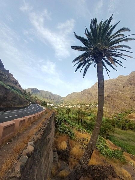
And we start the trip with music!
We start the trip with music!
When we started looking for a summer destination a few months ago, our first criterion was to avoid extreme heat and heatwaves. We had already been to Norway two years ago and are considering going back in the future for other occasions. So, we had some fun asking ChatGPT which destinations enjoyed a mild climate during the summer without going too far. Among the list provided by the AI were the Canary Islands... The idea of a place we wouldn’t have thought of first, both not too far away and exotic enough, appealed to us: “Hmm, why not?”
This destination had never really attracted me, though Magali was a bit more interested. Five years earlier, COVID had caused a short break in my professional activity, and I had planned a trip because the flight price was attractive, and I was looking for a destination different from what usually appeals to me, more than out of deep interest. From a distance and with a social judgment I acknowledge (it’s not great, but it’s not completely wrong), I had the image of a destination for party-goers enjoying the sun without the slightest interest in local culture, with concrete coastlines and denatured landscapes—everything I detest the most. Still, I had done some quick research on the different islands and spotted Lanzarote for its beautiful volcanic landscapes, hiking trails, beaches, and the impression of a good balance between activity and fewer crowds than Tenerife or Gran Canaria. Then I dropped the idea of going, without ever reconsidering traveling to the Canaries...
Until now! Because we started researching the different islands of the archipelago to see which ones might appeal to us the most. It was La Gomera, the third smallest island of the archipelago, more praised for its hiking trails and preserved nature than for its beaches, away from mass tourism (fifty times fewer tourists than Tenerife) but still a bit more developed than its wild neighbor El Hierro, that caught our attention. Contrary to what might be suggested later, I’m not at all addicted to AI, but I use it from time to time to synthesize quick research or simply for experimentation. Since ChatGPT had started anticipating my tastes lately as if it had become my buddy (often successfully, sometimes off the mark), I asked which Canary Island would suit me best for a trip with my family. The tool answered first with... La Gomera. So, I tested it and teased it a bit to see if this suggestion was well-founded, as the method sometimes makes it contradict itself. But no luck: “You’d appreciate the wild nature of El Hierro, but with family, you’ll find little activity for the kids. You won’t like the touristy vibe of the big islands like Tenerife, Gran Canaria, Lanzarote, and Fuerteventura. You could consider La Palma, but it’s really La Gomera that will suit you best, based on your interests and the criteria given.” So, we dug deeper into our research and were convinced without a shadow of a doubt that this island was the one waiting for us.
Without knowing it, we had Canarians in our circle who revealed their origins when they heard about our travel plans. One from Tenerife insisted we’d be better off choosing Tenerife (obviously...) because it also has preserved spots and that La Gomera, “you can explore it in two or three days, you’ll get bored quickly...” The other, a colleague from Gran Canaria who had never visited La Gomera, still recommended it without hesitation because it turned out her parents had just gone there on vacation: they loved it and had encountered few tourists. She also tended to think this destination was usually the subject of short stays, but according to what her parents told her, taking your time there was also a great idea. However, in our research, the idea that La Gomera is an island you can explore in three or four days max kept coming up. So, we considered combining its visit with La Palma or El Hierro, the other two that caught our eye. But hopping between islands by ferry represents a significant budget for non-Canarians, even more so for a family of four. Then, scrutinizing Google Maps, it seemed obvious that two weeks were too short to discover two islands as they deserve, and that there seemed to be plenty to see in La Gomera, given its very unique culture. After all, we read that some people spend several months a year there, others never even leave... Finally, these landscapes and this atmosphere, which seemed to us a mix of Europe, North Africa, and Latin America, tempted us. So, it would be two weeks in La Gomera, deal!
La Gomera is therefore the second... well, the third smallest island of the Canaries since La Graciosa was recently recognized as a fully inhabited island. It has the shape of a rough circle about 20 to 25 kilometers in diameter and has just over 20,000 inhabitants, half of them in its capital, San Sebastián de la Gomera, the only real town. Like its Canarian sisters, La Gomera is a volcanic formation that rose about 10 million years ago. The island is very mountainous and rugged, covered with red and black rocky landscapes. Geological activity has shaped, between the sprawling massifs that end in steep cliffs in the ocean, six coastal valleys with tropical vegetation that have favored human settlement. They divide the island like slices of a cake; from the north clockwise: the agricultural Vallehermoso, the rustic Agulo, the green, humid, and fertile Hermigua, the sunny capital San Sebastián de la Gomera, the southern and isolated Alajeró-Santiago, and the seaside Valle Gran Rey. They constitute the six municipalities (more like cantons to our French understanding) of the territory.
The large solidified magma massifs that shape the heart of the island have created a large depression more protected from the sun at its center, allowing the growth of a vast laurel forest, today grouped within the Garajonay National Park, La Gomera’s green lung, which has earned it the status of a World Biosphere Reserve. Its completely European appearance contrasts sharply with the rocky and tropical landscapes of the rest of the island. Thus, the climate varies greatly from one point to another on the island: in summer, you can quickly go from a dry and sunny valley at 35°C to a humid forest area at altitude at 18°C.La Gomera was populated late. As with the rest of the Canaries, human presence is thought to have begun about 2,000 years ago. Groups of animist Berbers, probably fleeing persecution, gradually populated the archipelago, especially the western islands and La Gomera, becoming its small aboriginal population: the Guanches (or later Gomeros). The animist and pastoral civilization of the Guanches thrived until the Spanish takeover in the 15th century, which, after a short period of harmony and mixing with the indigenous people, suddenly ended in bloodshed... La Gomera later became the “Columbus Island” after Christopher Columbus’s stopover, increasing the blending of populations. In the 20th century, many Gomeros emigrated to Cuba and other Latin American countries in search of a better life, bringing back a mix of cultures and traits quite palpable in today’s Gomeran culture. It is, however, in La Gomera that the vestiges of Guanche culture seem to have left the most traces, in the language, gastronomy, social practices... Moreover, most Gomeros, especially in remote villages, have a particular identifiable type and proudly claim their ancestral roots, even making La Gomera a bit exotic in the eyes of other Canarians.
Perhaps that’s why it has never really wanted to develop its tourist infrastructure too much. If we set aside the tourists who visit for the day by bus or boat from Tenerife on a marked itinerary (and whom we ultimately rarely encounter), La Gomera has remained a hidden gem, a destination focused on nature discovery that attracts hikers, nature-loving divers, and scientists for its fauna and flora, and to a lesser extent, beachgoers who don’t seek overly developed coastlines. Tourist activity is therefore limited. Roughly speaking, you’ll find a majority of Spaniards, including a substantial number of residents from other Canary Islands, many Germans who have a particular fondness for La Gomera and spend long stays there or own second homes, to the point that the German cultural footprint is clearly noticeable in some places (it’s said to be Angela Merkel’s favorite holiday spot), and still quite a few French. The presence of other nationalities seemed negligible to us. Most travelers come mainly for hiking, but it’s also a prime spot for whale watching. Additionally, the seaside resorts of La Gomera—San Sebastián, Santiago, and especially Valle Gran Rey—are well-known destinations for hippies, especially German ones, ranging from chic boho hippies to old-school hippies who’ve been there for decades, quite similar to those you’d meet in India in Goa, Rishikesh, or Paharganj. Thus, practices like naturism, vegetarianism, and local organic production are quite well established in some areas.
Some practical info: - The round-trip flight from Paris to Tenerife cost us 365 € per person (outbound with Transavia, return with EasyJet), including checked luggage and three seats reserved side by side. - We chose two bases to explore the island: one week in Valle Gran Rey, reputed to be the most pleasant of the three seaside resorts, and one week in Hermigua, more mountainous and close to the natural park. We booked two houses with balconies and views: the first at 120 € per night, the second at 99 €. - The round-trip ferry between Tenerife and La Gomera cost us 270 € with the company Baleària Canarias, including discounts for children aged 4 and 12, but I don’t have the exact details. It was a bit cheaper than with the other company, Fred Olsen. - Finally, we rented a car through the agency Cicar for 360 € for 16 days, which comes to 22.50 € per day. - Apart from that, we didn’t plan anything and decided the day before or even the morning of what we wanted to do. We didn’t invest in any paper guide on the Canaries, as information on La Gomera was scarce, but we used the very comprehensive site La Gomera Travel, a travel guide published by the Canary Islands Tourism Council, a real goldmine of almost exhaustive information on the island.
Alright, off we go for 16 days of adventure discovering La Gomera!
And we start the trip with music!
We start the trip with music!
Hey everyone!
New to the forum, but not so new to Asia 😄
I’m Nico, from Switzerland, currently based in Bangkok. I love taking my motorcycle out to get lost in the mountains and small villages of Thailand, Laos, Vietnam, and more. I’ve been roaming around this area for a good fifteen years now, racking up quite a few kilometers—especially in northern Vietnam.
This time, I finally decided to tackle the Mae Hong Son Loop, clockwise. I’d been to Pai several times before, but oddly enough, I’d never done the full loop.
So, I’ll try to give you a little recap here, day by day, with the roads, stops, places worth checking out… and those that didn’t quite blow my mind 😅
I also filmed the trip, so I’ll post the corresponding video at the end of each day if that’s okay. If it’s not allowed here, just let me know, and I’ll remove them without any issue.
DAY 1 — Chiang Mai → Doi Inthanon → Mae Chaem → Khun Yuam
I left Chiang Mai after renting a Honda ADV 160 from Pop Motorbike. Not exactly an Africa Twin, but for what I had planned, it was more than enough.
Quick hotel note: I stayed at the Lanna Thaphae Hotel before leaving. Around 30 € per night, super well-located, and probably one of the most comfortable beds I’ve ever slept in. A crucial detail for any motorcycle road trip, obviously.
The plan for the day was pretty straightforward:
Head toward Doi Inthanon… and see what happens.
Flawless Swiss organization.
First stop along the way at Wachirathan Waterfall. A really nice waterfall, very easy to access, but don’t expect to channel your inner Indiana Jones—it’s crowded, touristy, and swimming isn’t allowed. Still, it’s a pretty stop along the way.
Next, up to Doi Inthanon.
The road climbs steeply, and my little 160cc started to realize that carrying my 80 kg to Thailand’s highest point probably wasn’t part of its youthful dreams. I was maxing out at 34 km/h in some spots.
But it made it. Good little bike.
The summit is nice—the forest is beautiful, and it’s cool—but I have to admit, it didn’t completely wow me. Glad I went, but not necessarily the highlight of the day for me.
Because then comes Route 1192.
And that’s *much* more my thing: small mountain roads, beautiful scenery, hardly any traffic… the kind of road where I usually start taking way too many unnecessary detours just because a little side road “looks fun.”
Stopped in Mae Chaem for a bite to eat, then headed to Khun Yuam to finish the day.
A little over 200 km in total.
Khun Yuam is… quiet.
*Very* quiet. 😅
A cute little market, a couple of cafés/restaurants, and zero chance of ending up in a club until 4 AM. But after a day on the bike, it was perfect.
Stayed at the Mit Khun Yuam Hotel, around 20 € for a small but very decent room.
All in all, a solid first day and a pretty relaxed start to the loop. Part of this leg is mostly about getting out of Chiang Mai and really diving into the mountains, in my opinion.
Because for me, the really interesting stuff starts over the next two days…
And a few slightly questionable route decisions will also make an appearance 😅
If anyone’s planning the Mae Hong Son Loop, feel free to ask your questions—I’d be happy to answer!
I also filmed this first day, so for those who’d rather see the roads and landscapes than read my rambling, here’s Day 1 😊
DAY 1 VIDEO
I’ll post the next part in the coming days with Day 2: Khun Yuam → Mae Surin → Mae Hong Son.
And that’s where it starts getting *really* fun. 😉
That’s all for now! Looking forward to contributing as much as I can to the forum!