hi,
I'm planning a recumbent bike trip from the Pyrenees to Greece. On the EuroVelo 8 route, it doesn't specify the path through the Alps.
Are there any experienced cyclists here who can tell me where they go to avoid climbing too high?
Also, is there another traveler/bike forum better suited for broadening the responses?
thanks
Hi everyone,
I’m planning a cycling trip in Algeria and looking for concrete firsthand accounts from cyclists who’ve recently traveled there (or residents who know the terrain well). My goal is to map out a realistic 2–4 week itinerary that prioritizes discovery, safety, and solid water/bivouac management.
My profile and gear
Semi-bivouac autonomous cyclist (light tent + sleeping bag + stove), with the option of simple accommodations in towns.
All-road/gravel bike with a rear rack, 40–45 mm tires (I can go up to 47–50 mm if needed).
Compact drivetrain with a small gear range for climbing while loaded.
Modular water capacity of 4–7 liters (soft flasks + bottles), plus a filter and purification tablets as backup.
Navigation via offline maps + GPS, GPX tracks if available.
Planned period
Late winter/early spring (timing to be refined based on your feedback about weather, wind, and day/night temperature swings). I’d love a seasonal breakdown: which areas are more pleasant/rideable during this time? Are there zones to avoid while others become ideal?
Preferred itinerary style
High plateaus and accessible Saharan fringes for a loaded bike, alternating between secondary roads and rideable tracks.
Moderate pace (60–90 km/day depending on terrain and wind), with stops in resource towns to restock, shower, and rest.
Safety and logistics (water/supplies) take priority over pure athletic performance.
My specific questions for those who’ve cycled in Algeria 1) Routes and areas
Which roads/tracks did you enjoy for their scenery and interest without being too rough for a loaded gravel bike?
If you’ve ridden the high plateaus: which connections do you recommend to avoid traffic and stick to small roads?
Saharan fringes: which sections are realistic for partial autonomy (reasonably spaced water points, rideable tracks, not too much soft sand)?
Areas to avoid by bike (recently) due to security, road conditions, katabatic winds, construction, etc.?
2) Water and supplies
How frequent were water points on your routes: reliable wells? taps? sources in towns/villages?
In “desert” sections, how many liters did you carry between secure points? Does a 6–7 L capacity seem comfortable, or should I aim for more on certain stretches?
Food: small shops, markets, availability of basics (semolina, sardines, dates, biscuits, powdered milk, etc.) — how often can you reasonably restock?
Filtration: did a filter + tablets suffice? Are there areas where you’d advise against filtering from unprotected wells?
3) Bivouacking and accommodations
Tolerance for discreet bivouacking (far from dwellings, leave-no-trace): recent experiences?
Simple alternatives: guesthouses, small hotels/hostels, campgrounds (if any), municipal lodgings?
Practical stopover towns for restocking, resting, and securing your bike overnight: reliable spots or neighborhoods to prioritize/avoid?
4) Roads, tracks, and weather
Road surface quality on secondary routes: generally decent or highly variable?
Tracks: rideable (compact gravel, laterite) or sometimes sand/washboard? At what tire width would you recommend switching (45 vs. 50 mm)?
Prevailing winds this season: direction, strength, most exposed hours; do you adjust your departures to ride “before the wind” in the morning?
Temperatures: day/night range; sun protection (long gloves, buff, sunscreen, sunglasses), managing nighttime cold at altitude or in the open desert.
5) Safety, formalities, and connectivity
Recently discouraged zones (please note the date if possible).
Roadside checks: which documents to keep handy; are there specific registrations or declarations required upon arrival or when moving between wilayas?
Local SIM/data: which operators work well on the routes you took; tips for recharging/buying credit.
Useful apps/maps on the ground (and reliable offline maps) for locating water, grocery stores, garages, accommodations, rideable segments, etc.
Bike security: how did you handle anti-theft and parking during errands/overnight stays?
6) Gear and adjustments
Recommended minimum gearing for loaded climbs on local roads/tracks.
Ideal tire width and casing (puncture resistance on gravel and rocks).
“Sweet spot” water capacity based on your experience (and tips: frame bags, extra bottles on the fork, bladders in frame bags, etc.).
Maintenance: dust/sand — greases/seals, drivetrain cleaning frequency, breathable filters, protective socks for zipped panniers.
Sample itinerary outline (to validate with your feedback)
Week 1: Arrival, adjustments, high plateaus, linking resource towns to get into the rhythm, test supplies and water.
Week 2: Accessible Saharan fringes, alternating road/track, nights in discreet bivouac when possible + simple accommodations every 3–4 days.
Week 3–4 (optional): Extend toward a second Saharan area or head back to a more temperate zone depending on weather/wind, prioritizing routes known to cyclists.
If you have GPX tracks (even partial), waypoints (water, grocery stores, accommodations), or a travel journal with dates, I’d love to see them. Dated info (year/month) will help me weigh what may have changed recently.
What I can share in return
After the trip, I’ll publish a detailed report with:
Final itinerary + cleaned GPX tracks,
List of confirmed water points and open supply spots,
Gear review (tires, gearing, water capacity),
Notes on bivouacking/accommodations and safety,
Budget and daily distances, to help future travelers.
Thanks in advance for your tips, warnings, good addresses, and updated feedback. Your experience is invaluable for planning a safe, smooth, and enjoyable cycling route in Algeria. Happy trails! 🚴
I'm currently exploring how to create a travel itinerary using AI, specifically ChatGPT.
Question: Bike route from Bordeaux to Paris.
Rough response:
A bike route between Bordeaux and Paris is an incredible adventure, typically around 600 to 650 km depending on the chosen path. Here’s an example of an itinerary with key points:Main Option: La Scandibérique (EuroVelo 3) La Scandibérique is the French section of EuroVelo 3, connecting Bordeaux to Paris through stunning landscapes. This route is well-marked and takes you through small roads and greenways.Main Stages
Bordeaux → Libourne (about 40 km)
Follow the Garonne River, cross the vineyards of Entre-deux-Mers, and reach Libourne, a charming wine town. Greenways available.
Libourne → Périgueux (about 100 km)
Cross the Dordogne with stops in villages like Montpon-Ménestérol. Mix of quiet small roads and trails.
Périgueux → Châteauroux (about 160 km, in several stages)
Through the Parc Naturel Régional de la Brenne. This stage is longer but rich in nature and heritage.
Châteauroux → Orléans (about 110 km)
Reach the banks of the Loire to enjoy the famous Loire à Vélo, a beautiful section with châteaux.
Orléans → Paris (about 140 km)
Pass through the Forêt de Fontainebleau before joining the bike paths along the Seine all the way to Paris.
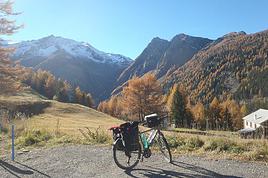
France, Switzerland, Germany, Austria via Claudia Augusta and Italy via the Padana (AIDA) Alta Italia...
http://cbandiera.free.fr/recits/2025-via-augusta/
2024 already done, 2025 in sight
About 2,460 km with the Alps to cross, of course.
Faverges, Annecy, Geneva, Yverdon, Bienne, Bodensee, Danube sources, Ulm, Donauwörth, Augsburg, via Claudia Augusta, Innsbruck, Bolzano, Trento, Nervesa, Treviso, Mestre, Venice; Via AIDA (Alta Italia da attraversare / Padana) Padova, Vicenza, Verona, Brescia, Milan, Novara, Vercelli, Chivasso, Turin, Susa, Mont Cenis Pass, Maurienne, Albertville, Faverges. A fantasy of Glaude’s for n+1 years For 2025? The story is already formatted
To be seen
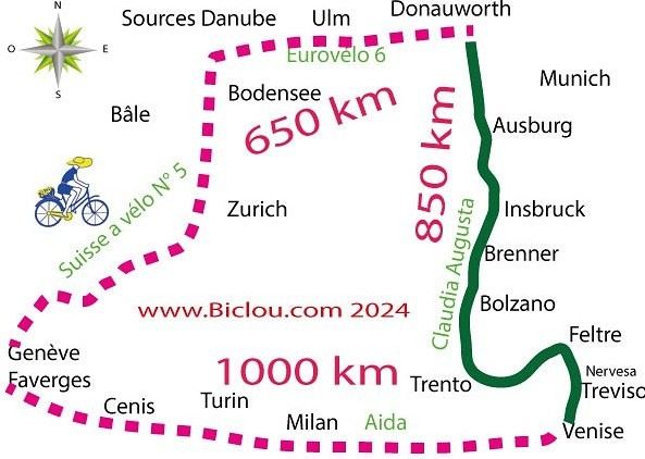
Hi everyone,
I’m trying to get familiar with a route on Locus Map. The issue is that Locus Map’s geolocation isn’t accurate on my PC.
In the link, the red cross shows where I live, and the blue cross shows where Locus Map geolocated me. There’s a difference of about 1.5 km.
My question is: will there always be this kind of error every time I ask Locus Map to geolocate me?
Hi there,
In 2022, I went to Japan where I planned to buy a bike (you need to know a trusted Japanese resident or similar, otherwise it's impossible, but you get a registration in return).
There are many websites selling second-hand bikes, accessories, and parts at all price points that you can find online.
I bought a suitable bike, the right size, for around 600 €, which allowed me to cover the 850 km I had planned.
For transport, you absolutely need a soft bike bag, because you must dismantle it to board any train or bus! And even to move it around the station!
For express trains in certain regions, you need to make a reservation for oversized luggage (check at the station), and in return, there will be a reserved space.
Keep in mind that Japanese people travel with little luggage since they rarely go away for more than a week. So, if you don’t end up with a crowd of tourists... (watch out on tourist routes in Tokyo and Hiroshima).
Avoid tourist areas during GOLDEN WEEK in April-May—trains and hotels are fully booked. Take the opportunity to escape to the countryside...
For hotel bookings, Booking and Agoda are safe options—you can confidently choose the cheapest ones.
In small towns, street life shuts down at sunset, so plan ahead for restaurants. Otherwise, there’s always the konbini!
For ferries, there’s no problem, but you may have to pay in some cases.
Otherwise, it’s all very pleasant: drivers are very respectful.
Bear in mind that driving is on the left side of the road.
I took a few trips around Tokyo and its suburbs without any issues, except for orientation. A GPS is essential because many people don’t speak much English or know exactly where they are in relation to your destination.
But luckily, there’s the KOBAN—a neighborhood police box where an officer has a big book of maps, and their mission is to help you find your way if you know the address, the neighborhood name, the subway station, or even the name of a bar (!)
Otherwise, I cycled on very small roads away from main routes, through small villages, and that’s where you really discover "deep" Japan.
Japan is a mix of landscapes, often wilder than what we’re used to in Europe, but also signs of an aging population, with rural exodus and many abandoned houses in the mountainous countryside of SHIKOKU or NOTO.
I explored or took rides from town to town, sometimes ahead of or behind my partner, who traveled by train or bus on her own.
I met few Japanese cyclists (with very basic bikes) or non-Japanese ones, except for cyclists on the SHIMANAMI route with amazing bikes.
No need for a heavy lock—you can find them there.
There are also shops for second-hand parts.
For safety, ideally, you should get a local SIM card. It’s good to know that in an emergency, your phone will work to call for help—dead zones are rare.
I brought the bike back to Europe as checked luggage in a properly sized box with no special formalities, for a transport cost of around 150 €. I got the box from an international bike shop in Tokyo after some searching and resizing it (with a knife and packing tape).
A firsthand account of a 30-day cycling trip (the length of the visa) in southern Vietnam, from Hue to the Mekong Delta. 1,500 kilometers pedaled in December 2022 and January 2023.
Roads and Traffic The roads are generally in very good condition. The secondary road network is limited. Since Vietnam is a densely populated country, needless to say, traffic is often heavy, including on secondary roads. Cyclists, along with pedestrians, are at the very bottom of the road-user hierarchy. In short, when you're on a bike, you never have the right of way. The atmosphere is deafening—Vietnamese people honk all the time. For a Western ear, it's hard to tell the difference between a honk that just signals someone's presence, one that warns of imminent danger, or an angry honk. 😏
Weather Vietnam is a long, narrow country (1,600 km). The weather isn’t the same in the north, center, or south. I cycled through the central part in December. Even though the monsoon peak had passed, I still encountered a lot of rain. Since the monsoon usually lasts until January, it might be better to cycle there starting in February. I was in the Mekong Delta in January. The best season, as it’s the driest month with the least hot temperatures. At this time of year, the prevailing winds come from the northeast. So, it’s better to travel from north to south. That way, you’ll usually have the wind at your back.
Accommodation I always stayed in hotels without ever booking in advance. Typically, I paid between 10 and 20 € for a double room with a private bathroom and AC. To find hotels, I used Google Maps and Maps.me. Wi-Fi is available for free almost everywhere.
The Route Hue → Danang → Hoi An → Nha Trang → Phan Rang → Tan Son → Dalat → Di Linh → Mui Ne → La Gi → Vung Tau → Nha Be → My Tho → Tra Vinh → Can Tho → Cao Lanh → Tranh Hoa → Trang Bang I took the train from Danang to Nha Trang. Not all trains accept bikes, so you’ll need to check beforehand. The railway handles bikes—they’re packed by staff and travel in the same train but in a freight car. I paid 14 € for the ticket plus 7 € for the bike (there’s an extra 0.50 € to pay upon arrival).
The Verdict So, is cycling in Vietnam worth it? If you enjoy biking in traffic, then yes. Otherwise... 😎
hey everyone,
I’m landing in Madagascar with a buddy before the end of April 2026. We’re planning to bike around for about twenty days or so. We don’t have a specific goal other than exploring the country and meeting the locals.
Ideally, we’d prefer a loop route starting from Antananarivo with a good chunk of it along the coast. On the bike side, we’re used to riding 6 to 8 hours a day, depending on the needs, encounters, and mood 😉 Any feedback or tips from trips around this length?
Thanks in advance, Jérôme
Hi everyone,
We’re planning to spend 5 months cycling as a family in Central Asia. To align with the weather, we’re thinking of arriving in Uzbekistan in April, heading toward the Ferghana Valley in late April/early May, and wrapping up with a long stretch in Kyrgyzstan from mid-May to early August.
I haven’t really dug into the third part (Kyrgyzstan) yet, but from what I’ve seen on the forum and online, cycling across Uzbekistan doesn’t seem all that appealing: long, straight desert stretches with lots of trucks.
Has anyone come across any "hidden gem" routes they’d be willing to share? I’ve already noted that it’s best to avoid riding toward Tashkent. I’m looking for routes between Bukhara and Samarkand, and any nearby areas that are nice for cycling.
I’d love to fly into Dushanbe to reach Samarkand, but we all agree that it’s not a good fit for the season (early April) if we’re cycling, right?
Thanks for your feedback! Ludo
Hi there,
I’m planning to bike back from Poland this summer. Does anyone know a way to ship it there without having to take it apart? Otherwise, it’s a real hassle to fine-tune all the settings before departure! Thanks in advance.
I’m planning to bike back from Poland this summer. Does anyone know a way to ship it there without having to take it apart? Otherwise, it’s a real hassle to fine-tune all the settings before departure! Thanks in advance.
Hi there,
We’re heading to three islands in March (Paros, Milos, and Sifnos). Given their small size and lack of major elevation, we’d love to explore them by bike. However, I can’t find any bike rental shops on any of these islands. Has anyone done this before and have any recommendations or addresses?
Thanks so much in advance!
Hi there,
My friend and I are planning to bike down to Tierra del Fuego starting from Santiago, Chile, in early February. The big question is: "Is it possible to find decent and reasonably priced bikes in Santiago?" Are there local resale sites like Leboncoin, or any second-hand spots worth knowing about there? If anyone’s done this before, I’d love to hear your tips! ;)
Thanks! !
Hi fellow travelers! I’m planning a trip to Japan from March 22 to April 12 and really want to bike the Shimanami Kaido starting from Onomichi, but I don’t cycle regularly. Has anyone here done it and could share their experience or tips? Is the weather in March-April favorable? Should I plan for 2 or 3 days? Electric or regular bike? What’s better—having my luggage forwarded along the route or leaving it in a locker? Any recommendations for accommodations or bike rentals? Thanks in advance for your replies!
Hi, I'm looking for a Pino tandem bike for sale in Quebec and I can't find any. Does anyone have any info, please? Thanks a bunch!
A shout-out to a cycling colleague from Savoie
Claudio specializes in the route of the Savoie lakes Here are his travels Between Bornes, Chartreuse, the Savoie foothills, and Dauphiné Five lakes: Léman, Annecy, Paladru, Aiguebelette, Bourget, not to mention a few ponds along the way Plenty of accommodation options: camping, hotels, and more...
A lovely route not far from his place Rural and quite peaceful A road cycling route created by Serge B...
N+1 reconnaissance trips on a loop of about 400 km This way, he avoids the SNCF and its troubles http://cbandiera.free.fr/vv/lacs-savoie/recos.php

The latest reconnaissance trip from April to May 2026 http://cbandiera.free.fr/recits/2026-grenoble-H/index.php

Claudio specializes in the route of the Savoie lakes Here are his travels Between Bornes, Chartreuse, the Savoie foothills, and Dauphiné Five lakes: Léman, Annecy, Paladru, Aiguebelette, Bourget, not to mention a few ponds along the way Plenty of accommodation options: camping, hotels, and more...
A lovely route not far from his place Rural and quite peaceful A road cycling route created by Serge B...
N+1 reconnaissance trips on a loop of about 400 km This way, he avoids the SNCF and its troubles http://cbandiera.free.fr/vv/lacs-savoie/recos.php
The latest reconnaissance trip from April to May 2026 http://cbandiera.free.fr/recits/2026-grenoble-H/index.php
Hi,
A friend is looking for a bike to embark on a long trip, but the issue is he’s only 1.55m tall.
In itself, that’s not a problem 😏, except that finding an XS-sized touring bike isn’t easy.
Some start at 1.55m, but it’s still a bit extreme.
If anyone knows of brands or models that might work...
Thanks in advance
Hi there,
New to bike touring,
I’d love to start with a section of the Via Rhona to explore and share (route to be decided).
Looking forward to exchanging tips!
Hi,
I’ve browsed the forum but can’t find an answer to my question: Which brand offers bikes suitable for bike touring for an 11-year-old / 140 cm tall? The D4 range is really limited... We’re looking at covering about 50/60 km max per day.
Thanks in advance for your suggestions!
I’ve browsed the forum but can’t find an answer to my question: Which brand offers bikes suitable for bike touring for an 11-year-old / 140 cm tall? The D4 range is really limited... We’re looking at covering about 50/60 km max per day.
Thanks in advance for your suggestions!
Hi, I’m looking for info on doing a solo bike trip from Chelyabinsk to northern China via Omsk. What’s the best time of year to go? Can I do it staying only in hotels and restaurants—without having to haul a tent, stove, etc.? Also, is there a border crossing point in northern China, because I can’t find anything on Google Maps? What’s the road condition like? Thanks
Hi everyone,
I wanted to share with you the incredible feat my friend José, who’s 72 years old, is currently undertaking. He left Auterive near Toulouse on Monday, May 18, 2026, on his non-electric bike, heading for the North Cape in Norway!
You can follow his route on the link below—he’s currently in Sweden:
https://thierry-thomas.travelmap.net/jose-de-toulouse-a-nord-cap-2026
You can zoom in on the map and click on each stopover town to see the photos
Coming soon:
https://www.Biclou.com/parcours/durance/
Starting from Faverges: 900 km over 9 days

Here’s the detailed Durance route starting from Briançon
Here’s the detailed Durance route starting from Briançon
Hi! I’m planning to visit the Stockholm Archipelago by bike in early April.
Do you know if the boats will be running between the different islands at that time of year? For those who’ve already been, all your tips and recommendations are welcome—accommodation, etc. Also, do you know where I can rent a bike in Stockholm? Thanks so much in advance for your help!
Hi there, we’re planning a Munich to Venice bike trip at the end of June 2026. Getting back from Venice to Toulouse by train with 4 bikes isn’t straightforward. What return options have others who’ve done this trip chosen? Any tips or great deals would be much appreciated. Thanks a bunch! !
Hi there,
We're thinking of cycling from Lisbon to Vila Real de Santo António in March.
Staying at campsites along the way.
I have two logistics questions:
1) Where to leave the van in Lisbon? Would it be okay to leave it a bit outside Lisbon if needed?
2) Can we take the train back from Vila Real de Santo António to Lisbon with our bikes?
Thanks for any insights!
Momo
I have 5 months left to prepare for the most ambitious project of my life...
In 5 months, I’ll hit the road, heading to Nepal. Not by plane. Not by train. But by bike.
13,000 km, 18 countries crossed. Powered only by my legs, my will, and a dream.
This journey isn’t just a physical challenge. It’s:
🌍 A human and cultural adventure, meeting locals, landscapes, and traditions. 🌱 A meaningful project: discussing climate change and, above all, listening to those who experience it daily. 🔥 An inner quest, to push my limits and inspire others to step out of their comfort zones. A message of hope for self-discovery.
I have 20 weeks left to: ✅ Finalize my route ✅ Gather the budget and equipment ✅ Sort out the logistics ✅ And most importantly… find committed sponsors to bring this adventure to life.
Any help is welcome!
Hi everyone here who loves cycling,
I’m planning a 5-week trip next January in Uganda: a little tour of 1,200 to 1,500 km crossing the most beautiful spots and reserves in the country. Route to be defined together.
I’m looking for someone to join me.
Interested? Nicolas (72 years old)
Travel site: nicolas.saulnier.free.fr
Interested? Nicolas (72 years old)
Travel site: nicolas.saulnier.free.fr
Hi there,
Has anyone here cycled in the Canary Islands in August? Is it not too hot? Not too crowded on the roads?
Thanks
Hi everyone, I’d love to bike from Lyon to Marrakech or Agadir. I’m looking for someone around my age (23) to join me. I’m also after some tips on routes, things to know, etc. This road trip is planned for September 2026. Looking forward to your replies and advice!
Hey fellow cyclists,
Cyclists on trails, paths, or greenways—why do so few (if any) of you use your bells to warn walkers, runners, and other pedestrians when they’re moving in the same direction as you?
I exercise every day (brisk walking) among you in France and abroad, and it’s something I’ve noticed—often with a few scares (and I’m guessing some accidents between cyclists or with pedestrians).
Personally, I always stick to the rules, walking on the left (facing traffic) so I can see you coming, but not everyone does that—neither pedestrians nor cyclists, and let’s be honest, it’s a bit of a free-for-all. 🤪
Your bikes make little to no noise, so why take risks and put others at risk too?
A quick, light *ding-ding* would be enough to warn people—what do you think? 😅
What’s the maximum weight of gear I can carry in my panniers:
- For a woman on an e-bike
- And for a man on a muscle-powered bike
Thanks