Bonjour à tous,
Nous envisageons un trek en Alaska en juillet 2012. A peine revenu d'Islande, nous organisons un nouveau départ. Quelqu'un connait-il un trek de 5 à 10 jours en Alaska, qui puisse allier marche et peche ? Nous sommes déjà pas mal affûtés. Nous n'avons pas peur du franchissement de cols ou des traversées de rivières. Que ceux qui ont eu la chance de faire un trek en Alaska en témoignent !
J'aurai besoin aussi d'une carte topo compatible avec mon GPS etrex HCX.
Voilà pour démarrer une discussion...🙂
Bonjour,
En Alaska il ya de quoi faire....
mais 5 ou 10 jours , déjà, c'est pas tout à fait la même chose....
Ensuite, quel type de "trek" : boucle, points de départ et d'arrivée accessibles par voie terrestre, aquatique, ou avion/hydravion ? "trail" tracé et balisé ou traversée à la Emeric FISSET ? (a lire absolument pour préparer et comprendre ce qui vous attend). Pêche : quelles espèces recherchez vous ?
Lis deja le rapport de mon voyage de rando en Alsaka: http://voyageforum.com/v.f?post=3446658
Parmi les choix, le PN Denali, la Chilkoot Trail ou alors les differentes randos au Sud d'Anchorqge vers Seward.
Par contre, pour la peche, je n'y connais rien.
Bonjour, bonjour,
Nous cherchons un trek d'un point A à un point B. Quant au moyen de s'y rendre, pourquoi pas l'hydravion... Le moins cher possible, bien-sûr. Je préfère les trails qui ne sont pas balisés; juste l'itinéraire sur le topo et la carte. Je ne connaissais pas Emeric Fisset : un fanatique de voyage, manifestement ! Je connaissais par contre la famille Ducoin (qui habite d'ailleurs dans mon coin...). L'année dernière, nous sommes allé marché dans le Yukon, dans le parc de Kluane. Pendant nos préparatifs, nous avions assisté à une conférence de Ducoin.
Nous avions pu mettre un pied en Alaska, à Skagway. Mais nous cherchons quelque chose de beaucoup plus sauvage... Le Chilkoot, par exemple, s'avère pour nous beaucoup trop fréquenté.
Pour ce qui est de la pêche, j'improviserai en fonction du site. Avec un lancer téléscopique et quelques leurres, je m'en sors. J'ai eu beaucoup de plaisir à pêcher de la morue arctique au Groenland, depuis la côte, ou des ombles et des truites en rivière, en Islande. Le saumon en Alaska peut-être ?
Willemspie, je vais jeter un coup d'oeil sur ton rapport de voyage...
Re...
Emeric Fisset, oui, c'est un costaud, un vrai ! On peut ne pas apprécier certains aspects du personnage, mais il faut lui tirer son chapeau. Et puis ses bouquins sont extrêmement documentés sur tous les lieux fréquentés. Du solide, du complet, du vécu !
Ducoin ? J'ai rencontré l'un d'eux, le père, chez des amis en Alaska il y a déjà quelques années...
Revenons à vos trails : ce n'est pas ce que je connais le mieux, des trails de plusieurs jours, étant plus porté sur les descentes de rivières, pêche oblige....
Un trail où vous n'aurez pas foule : Circle-Fairbanks Historic Trail. Départ ou de Fairbanks ou de la Steese Highway, mile 86. Longueur 60 miles environ.
Je ne vous en dirai guère plus, ne l'ayant pas fait.
Plus proche d'Anchorage et de la "civilisation" mais très beau : Resurrection trail system, que l'on peut coupler avec le Johnson trail et le Russian trail system.
Dépose (et reprise) en hydravion ça ne va pas avec "moins cher possible" malheureusement.
Pour la pêche en Alaska (la vraie, hein, pas estourbir des pinks avec une pagaie), excusez moi mais....improviser c'est le meilleur moyen de se planter... et n'oubliez pas que même en plein bush il faut se conformer à la loi (licence en règle et respect des "régulations" parfois assez compliquées et sujettes à changement au jour le jour).
A+
La solution la plus facile et la moins chere c'est le reseau de sentiers (en general tres faciles) au Sud d'Anchorage. Resurrection Pass, Russian Lakes, Johnson Pass, ...
C'est vraiment dommage d'aller en Alaska sans visiter Denali NP, il est possible d'y organiser une rando hors sentier assez longue mais je crains que la peche ne soit interdite dans les parcs nationaux.
Bonsoir,
Resurrection, Russian, Johnson, vous n'avez pas le sentiment de faire un peu le perroquet ?
Erreur : la pêche n'est pas interdite dans le Denali National Park. Le problème, c'est qu'il y a fort peu de poissons car ce sont des "silty rivers"... Tout juste quelques petits arctic graylings dans Savage river.
Le Denali NP me semble être très frop fréquenté et trop balisé. Et effectivement, il n'est pas réputé pour la pêche.
Je regarde un peu le Chugach NP. De très beaux paysages, du poisson, mais peut-être trop réputé, justement.
Peut-être faut-il aller voir plus loin d'Anchorage. N'y aurait-il pas des formules avec hydravion ?
Bonjour,
Le Denali est effectivement très fréquenté, mais pas balisé du tout (sauf quelques petites boucles près de Riley creek ou à Savage river).
Il est exact que la majeure partie des touristes ne s'éloigne guère des bus et de la route. On peut donc s'y faire un itinéraire solitaire de plusieurs jours, mais il est obligatoire de consulter le visitor center pour un back country permit, et ce sera bien entendu sans trail marqué.
Le Chugach National Park....n'existe pas. C'est le Chugach State Park, la différence est un peu comme chez nous celle entre les parcs régionaux et nationaux.
Pour la pêche il faut être de préférence !!! au bord de l'eau. Et au bord de l'eau c'est le bush. Et dans le bush on ne se déplace pas en été comme sur la toundra sèche.
Donc si tu veux vraiment pêcher, la solution serait plus une descente de rivière.... avec - selon les remontées - plein ou presque pas de poissons, ou un parcours dans le Nord, au delà des zones forestières (Nettement plus au Nord que Fairbanks) Les poissons ne seront pas les mêmes (surtout des grayling, et, plus aléatoire, des arctic chars). Les deux avec dépose par avion/hydravion. Cher, forcément, et logistique sans faille !
NB : attention certaines rivières sont fly only. Et la pêche avec un accès par la route, lorsque le poisson est là c'est "combat fishing", c'est à dire la grosse foire. Je doute que celà soit ta tasse de thé !
A+
Les vacances se profilent vraiment à l'horizon 😎. Je reprends donc le fil de la discussion. Nous nous fixons sur le Denali Park, compte tenu des moyens de transport (le train).
Par contre, nous voulons faire un trek de 10 jours sur un itinéraire non balisé (ou deux à suivre), mais avec topo. Connais-tu un topo qui vaille le coup, question paysage, marche et éventuellement pêche ? Est-il possible, par exemple, de partir et d'arriver à des stations de bus différents ?
Bloavez mad !
Si je comprends bien vous rejoindriez Le Denali National Park par le train ? Je pense que c'est une bonne idée, bien qu'il il semble que ce ne soit pas le moins cher.
Je ne connais pas de topo de ce genre sur le Denali, où à part des "day trips" vers l'entrée, il n'y a pas de "trails ". N'hésitez pas à les interroger à partir du site du parc (nps.gov).
Le Denali est en fait une région orientée Est - Ouest selon la direction de la route qui le traverse. Mais le relief est nettement Sud - Nord; toutes les rivières coulant grosso modo dans ce sens. Donc j'imagine qu'un trip assez long devrait se faire ainsi Sud Nord puis Nord sud en longeant deux rivières, pour éviter d'avoir à en traverser plusieurs (ces rivières sont très dangereuses).
Oui il est possible de partir d'un endroit depuis le bus et de le reprendre à un autre, n'importe où sur la route du parc.
Pour votre trip il vous faut demander un back country permit. Pour pêcher il vous faut également obligatoirement une licence (en vente dans toutes les boutiques d'outdoor à Anchorage: REI, Mountain View sports center, The sportsmen warehouse etc...)
Mais je me permets de vous le rappeler, pour la pêche le Denali c'est pas vraiment ça !
Il y a certainement plus de saumons dans le Blavet que dans la Toklat !
A+
Le transport le moins cher pour Denali c'est alaskashuttle.com, je crois. Tu peuf faire 10 jours a pied dans le parc, tu peux dans ces 10 joyrs reprendre le bus ou et quand tu veux, pour te concentrer sur les secteurs interessants, comme 12-13-14 et 6.Par contre, tu dois reserver tes nuits au depart a l'entree du parc, quelle nuit dans quel secteur. Et emporter 10 jours de bouffe dans les cylindres harmetiques, cela va etre un probleme. Tu peux entreposer de la bouffe dans des lockers a Eielston, et dans yn coffre a un autre endroit, pendant que tu marches dans le coin.
Merci pour les infos.
Willemspie, peux-tu me dire à quoi correspondent précisément les secteurs 12, 13 14 et 6 ? Pour la nourriture, nous avions déjà réussi à faire tenir nos 10 jours dans les canisters lorsque nous avons randonné dans le Yukon. Merci les Lyophilisés !
Bonsoir,
Les secteurs 12,13,14 sont intéressants certes, mais la route les longe...
Il y aurait aussi Stony Hill (33) puis (39) et retour le long de la Toklat (38)...Mais on n'est pas à votre place.
Ce qu'il vous faut avant tout c'est une carte détaillée où ces "units" apparaissent. Par exemple (séries "Trails ILLustrated Map") : National Géographic 222 : Denali National Park and Preserve Topographic Map. Je l'ai trouvée sur place...
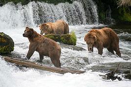
Juste une petite remarque a propos du tracé circle Fairbanks, c'est la zone la plus touchée par les attaques d'ours en Alaska... C'est bon a savoir :D!
J'habite juste a coté et les histoires sont nombreuses...
Je suis dans le même cas, trouver une rando de 10 jours ou plus en Alaska, c'est pas évident, surtout sans packcraft m'enfin l'Alaska ça se mérite!
Bonjour à tous, et merci à chacun (spéciale dédicace à Cheechako !)
Grâce à vous, nous avons organisé notre trek en Alaska pour le mois prochain : 8 jours de randonnée dans le Denali.
Je posterai un message à notre retour.
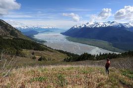
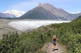
De retour de notre périple, je peux confirmer que le parc de Dénali vaut vraiment la peine. Il est peut-être tout même un peu trop organisé. Les bus "camper" sont très pratiques. Par contre, les découpages en unités avec réservations obligatoires constituent un vrai casse-tête pour qui veut faire une randonnée itinérante.
La péninsule de Kénaï est très belle : un paradis du pêcheur pour celui qui aime les sites fréquentés (pendant cette période du saumon). Du fait de l'effervescence due à la remontée des saumons, je déconseille Kénaï City et Soldotna. Mais, je conseille vivement Whittier, Seward et la randonnée d'Exit Glacier. Bien qu'on ne l'aient pas faites, les randonnées de la forêt de chugach (resurrection pass par exemple) avaient l'air tentantes.
Je vous invite à visiter ce lien où vous trouverez quelques unes de nos photos : http://www.flickr.com/photos/pastout/
Bon voyage à ceux qui partent et bon courage à ceux qui reviennent.
Coucou les Pataugas !
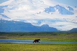
De retour à Anchorage après un trip ciblé pêche aux ombres arctiques, très loin de Kenai et des foules qui fréquentent les rivières de cette région, nous avons fait un saut au Dénali National Park, et avons eu une pensée pour vous.....
Dans quelques jours redépart vers le Nord...
A bientôt.
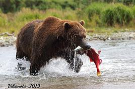
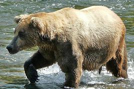
Vous devriez avoir honte d'écrire des choses pareilles... à des pauvres randonneurs forcés de reprendre le travail et d'attendre leurs prochaines vacances !
En effet, c'est moi qui l'ait faite : il s'agit de mon beau-frère, le jour de son mariage avec ma soeur !
Non, plus sérieusement, j'ai du trouvé cette photo d'ours il y a déjà un petit bout de temps sur le net. Mais je regrette de ne pas l'avoir faite moi-même !
Afin de pouvoir réaliser mon aventure en Alaska, j'aurais des questions à poser à une personne résident en Alaska ou ayant longtemps vécu. Si c'est le cas,…
Partant pour la première fois en Alaska, ma compagne et moi avons prévu de passer quelques jours au Denali National Park. Nous aimerions profiter de ces 3…
Après 2 été en chine à me perdre (et à suer sans retenue) dans les petits villages dong et miao, je devais aller en février 2020 découvrir la rigueur de…
Mon conjoint et moi allons voyager 2 mois cet été dans le nord-ouest canadien et américain, dont un mois complet en Alaska et au Yukon (aout 2016). Nous y…
Comme beaucoup d'entre vous, j'ai décidé de partir durant un mois dans l'Ouest Canadien. J'ai très envie de faire à la fois l'Alaska, le Yukon et la Colombie…
Hi,
We’re planning to do the 4-day trek from Mestia to Ushguli without an agency. The descriptions mention that there are accommodations at each stop, but we can’t find any details about them. Has anyone got info or feedback on this route?
We're planning to trek in Peru and Bolivia and would love to find some local agencies.
If you know any, could you share details on prices and, of course, the names of the agencies?
Which trek would you recommend?
Elocine
Je pars en autonomie totale sur un trek au Maroc (10jrs) Imilchil - Aghbalou.
Trouve t-on des cartouches gaz à vis (Coleman, Primus) à Marrakech (adresse) ou villages entre Imilchil - Aghbalou ?
Si non , trouve-t-on des cartouches Butagaz pour camping-gaz (petit volume 230 gr ...)
Merci d' avance pour vos réponses
Hello, I’d like to embark on a little trip in my home country, Switzerland. I’ll start walking from La Cure, heading toward Le Noirmont first, then I’ll improvise my route—but it’ll probably follow the French border... at least as far as Lac de Joux.
I’ll decide day by day how much farther to go after that. My goal is to stay in nature as much as possible, wander around for as long as I can, and restock food in villages or towns along the way.
I’m thinking of mostly camping, but we’ll see if I end up in a hotel or another campsite depending on my route.
I’d love to reach La Chaux-de-Fonds on foot... maybe even Delémont.
The whole thing should take about a week, give or take.
I’ll be bringing my dog, and I’m preparing for this as soon as I’m ready.
Any tips to make sure everything goes smoothly for us? Things I should know—or avoid? What about shepherds with their flocks of sheep? And isn’t hunting season open right now?
I’m not sure if what I’m planning is even doable, which is why I’m asking around.
This’ll be my first time doing something like this—wandering in nature *and* with a dog. I’m really excited for this adventure... and I need it. Thanks!
We’re really keen on ecosystems and want to hike in "natural" ancient forests—not planted woods or areas heavily degraded by human activity. Travel guides (like Lonely Planet) don’t provide much info on this. Could you point us to the most interesting spots?
Thanks in advance for your tips.
We wish you happy holidays and a fantastic 2026, full of discoveries!
Claire and Albert
Hi, this might not be the right section, but I’d like to know if it’s possible to start mountaineering with another person without necessarily hiring a guide. We’ve done quite a bit of hiking but not mountaineering—we’ll just do a half-day glacier course. After that, we were thinking of starting with La Grande Motte and the Pointe de la Traversière, which were recommended to us. Honestly, for things like roping up and knots, I’ll learn at home with lots of videos and a book.
Jaimerais savoir si quelqu'un aurait fait des treks sur le Ruwenzori et combien ça coute en moyenne, les infrastructures, les paysages la sécurité sur les lieux, merci beaucoup. J'attends avec impatience vos réponses.
We’re leaving in 9 days for a two-week trip to Madeira, mainly to hike.
From my research, I’ve found that since last year, access to most trails—and systematically for the most popular ones—is now paid. You have to pay an access fee of 4.50 € per person per classified hike in 2026, and even 10.50 € for the most iconic hike: Pico Arieiro to Pico Ruivo. When paying, you also have to choose a day and a 30-minute time slot for your start time. Of course, this reservation is neither changeable nor refundable, even if the weather that day is terrible.
Personally, given the massive influx of tourists to the island in recent years, I don’t mind paying a fee to help maintain the trails. Similarly, setting a limit on the number of people who can hike them per day is certainly preferable to preserve this priceless heritage.
However, what’s much less fair is that in reality, most of the available spots are reserved: 1/ for Madeira residents (which is normal); 2/ for "economic operators" (meaning local tour operators). For example, if you’re a non-resident (independent tourist), no booking is possible for the Pico Arieiro hike for an early morning start before September! So, unfortunately, we’ll have to skip this hike.
It’s the same issue for Ponta de São Lourenço, the 25 Fontes, Pico Ruivo... in short, all the most popular hikes. Oh well, we’ll skip those too!
So my question is: which hikes do you recommend where we won’t face the huge crowds that the others get? And where we can book the day before for the next day, taking the weather into account?
Finally, a quick accommodation question: we’ve booked the first week in Funchal, but I haven’t decided yet for the second week. Do you have any advice on where to stay in the south or north, preferably avoiding overly concrete-heavy and touristy spots?
I’m reposting about the logistics for Samaria Gorge.
I’d love to get recent info, especially about whether it’s possible to park my car in Omalos, do the hike, and then catch a bus back to my vehicle.
In theory, it’s doable, but when you check the KTEL website, there aren’t any feasible schedules listed. If anyone has recently organized this with reliable, verified details, I’d really appreciate it. Thanks in advance!
Hi there,
We’re flying from Montreal to Lyon this August to go hiking in the French Alps. We’ve rented a car and will be staying at campgrounds. We’re planning to do day hikes and want to stay a few days in one spot, do a few hikes, then move on to our next camping spot. Could you share your favorite spots or any recommendations for places to spend a few days with great hikes?
A few details:
We arrive in early August and leave in early September.
We’re looking for day hikes (or shorter), moderate difficulty, with a cumulative elevation gain of no more than 1000m, and of course, beautiful scenery!
We’d prefer not to drive too much—maybe it’s best not to head too far south and deal with unnecessary heat?
Along the same lines, if you know of any great campgrounds where we can start our hike directly without needing the car, we’d love to hear your suggestions!
Bonjour
Souhaitant faire de la randonnée sur cette île, je voudrais d'abord savoir quelle serait la période la plus favorable sachant que j'avais passé quelques jours en novembre 2018 pas pour cette activité mais plus pour une simple découverte de l'île et le temps n'était pas top notamment en montagne. Donc peut on choisir une organisation en étoile sachant que je louerai un véhicule avec éventuellement 2 points d'hébergement.
Je n'envisage pas d'intégrer une structure mais de partir à 2 et de s'organiser sauf si vous me conseillez une agence locale ou un guide local. Enfin même si je compte me procurer les différents supports, carte et topo guide plus gps je vous remercie de bien vouloir me communiquer les randos à faire en priorité
Merci beaucoup pour vos informations
I’m planning to do the Mercantour crossing following the Randoxygène route in mid-July.
I’m used to hiking in the mountains, but I sometimes get vertigo, for example on ridges with drops on both sides. I wanted to check if there are any T4 or T3-T4 sections and find out if there are any very exposed passages—and if so, where—so I can plan an alternative route.
Can anyone give me some info on this?
Thanks!
I’m planning a trip around Cap Corse and the AGRIATES in 2026, from May 8th to 15th (there are still 2 spots left, by the way! Just DM me if you're interested).
I’d love to know which hikes are worth prioritizing in the AGRIATES. We’ll be staying in SALECCIA for two days as our base—what should we focus on from there?
A round trip to IGNHU beach? Any other suggestions?
For Ostricano, I think it’s too far for a round trip...
Thanks for your tips!
Have a great day,
Anie, Toulouse
I’d like to get some info about the GR10 Pyrenees traverse. I need help planning the daily stages and accommodations—my wife isn’t an experienced hiker but walks a lot, so I’d like to schedule shorter walking days and thus a longer overall trip in terms of number of days.
Could anyone give me some help and advice?
Best regards,
New to this forum, I’m planning a pretty big project for 2028.
I’m heading to Nepal to do a trek from Kathmandu all the way to Everest Base Camp (a cool 5,300 m 😄).
This trek is a bit special because even though I’ll be part of a group, I’m going solo (so far, no problem—I’m used to it). But it’s my first real trek, and it’s also a humanitarian one: once I reach base camp, I’ll stay an extra week to help clean up the waste left by tens of thousands of climbers! Since I’m originally from South America, from two countries that share the Andes, I have a deep respect for mountains—they fascinate me. So Everest… it’s kind of the trip of a lifetime!
So, a little question for those who’ve done treks to Everest before… any tips for good mental preparation (I’m already working on the physical side)?
Hi there, I’m planning the Annapurna Circuit for March 2027 and I’m looking for a local agency with a local guide—preferably French-speaking—to arrange this trek for us. Any suggestions? Thanks
Hello!
We’re spending a few days in Toraja country at the end of May. We’d love to do a day trek—taking our time—on a route that’s stunning in terms of scenery, but not a level 5 in difficulty!
Any suggestions you can share, please?
Thanks in advance
I’d like to do the Mare a Mare Sud in May over 4 days. I’ve found quite a few places to stay along the route, but I’m stuck on the start and finish.
I’ll be arriving by plane on Sunday evening and would like to start pretty early on Monday morning. Ideally, accommodation right at the trailhead (Alzu di Gallina) would be amazing, but I can’t find anything. Any tips?
Also, for the transfer from Figari Airport to Porto Vecchio or Alzu di Gallina?
At the end, I’d like to pick up a rental car—any advice on that too?
I’m traveling solo by plane to Catania in May and plan to hike the northern side of Etna, starting from Linguaglossa where I’ll arrive by bus. After that, I’d love some info on how to get up to Piano Provenzana (shuttles or hitchhiking), since it seems there’s no public transport except in the summer. Can you sleep there in a free or cheap refuge, or camp? And how far up can you go without having to hire a guide? Thanks in advance. Bernard.
Bonjour a tous,
je pars en voyage au Maroc en aout et nous allons commencer par nous arrêter a Chefchaouen(nous sommes en voiture).
Ma question: quelqu'un peut il m'indiquer un itinéraire de rando en boucle d'entre 5 et 7 jours aux départ de Chefchaouen dans le parc de Talassemtane passant si possible par le pont de dieux?Ou un guide papier qui en reunis quelques uns?
Nous privilégions le camping sauvage et les gites.
Merci d'avance
Hi there, for those who’ve been recently—is it possible to find other solo travelers in March on the island to share transport or room costs? It doesn’t seem easy to travel on a budget.
If you have any recommendations for simple lodgings or places with dorms, I’d love to hear them.
For those who’ve done multi-day treks while moving around: do you need to bring your own sleeping bag? I’d love to hear about itineraries you’ve done without a guide, just with a map and GPS.
Thanks, and have a great day!
Hi everyone!
We’re planning a 15-day road trip to Scotland this summer, specifically to explore and hike on Lewis and Harris—places we’ve never been before. We’ve visited other islands on previous road trips in Scotland (we usually go in April for a week). This would be our first time in Scotland in the summer and for 15 days. We’re looking at late August to early September.
I’m currently drafting the itinerary. We’d be crossing from Ullapool and were thinking of spending 3 nights on Harris and 4 nights on Lewis.
Does that sound balanced to you? Is it better to keep the same accommodation on Harris and the same on Lewis to explore the area? I’d love to hear about any past experiences you’ve had on these islands.
Thanks!
Hi there, I’m trying to leave for 15 days very soon to São Vicente. I’m either looking to join an agency or figure things out on my own to go hiking on one of these islands or both. From what I’ve seen, it’s not easy to organize with local transport, so it gets expensive. Can I use the services of a small local agency? I’m looking for the simplest way to hike for several days. Also, how do you get from São Vicente to São Nicolau? Thanks in advance and have a great day!
Aichatou
I’ve been wanting to do this for several years, and this year’s the one. Next September, I’ll be trekking in Tusheti (Georgia), from Omalo to Shatili.
Of course, I won’t be renting a vehicle that’d just sit unused. No problem getting to Pshaveli, but from there to Omalo, it’s a dirt road (still the case?)
There must be some form of public transport since there are so many guesthouses, and not all travelers come in a 4x4.
If any of you have been to Omalo, could you confirm that these shared transports exist and how often they run?
we’re planning a trip to Yellowstone and hoping to do a three-day backcountry hike if we get a permit.
if any of you have done this before, could you let me know if it’s possible to find water along the way? And if we can transport it, are we allowed to use a stove?
Hello,
I’ll be in Nepal from March 6th to 29th (we’re flying into Kathmandu via Varanasi and leaving via Delhi).
I’m a bit confused about the regulations requiring a guide.
My wife and I (we’re 63 and 64) aren’t experienced trekkers—we’re more used to walking on terrain with very moderate elevation changes. I’m looking for fairly easy hikes, possibly day trips.
Here are my questions:
- Does the Poon Hill trek from Pokhara require a guide, or is it better to go through a local agency? (I’ve seen a lot of them offering 4-day packages)
- I’d like to do a few multi-day hikes around Jomsom (Kagbeni, Mukitinath, Lupra, Marpha)... Do you need a guide for those, and can you find accommodations easily without booking in advance?
Last question—I’m really hesitant to lug around a sleeping bag or down jacket during our 6 weeks in India. Can you easily find these kinds of items at reasonable prices in Pokhara?
Thanks in advance for any tips you can share!
Yann
I’m a 56-year-old man who’s done several treks in Nepal and elsewhere. Also passionate about photography.
I’m looking for one or more people to form a group for a trek in Nepal. The trek is the Annapurna and Manaslu circuit (24 days), including a stop at Tilicho Lake. I’ve got a great itinerary and the local company seems solid. The price is around $1600.
I’ll be in Nepal from April 5 to May 12, 2026, so the trek would need to happen within those dates.