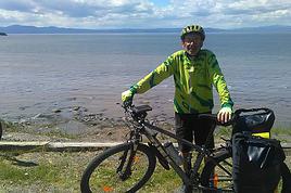
Nous envisageons de faire quelques randonnées "en dehors des sentiers battus" et je m'interroge sur la nécessité d'acheter un GPS de randonnée.
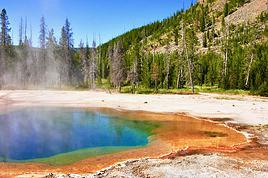
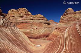
Parmi les randos ou je crains le plus de nous perdre il y aurait The Wave où j'ai la chance d'avoir obtenu des permis, yellowrock, mill creek à Moab et Wahwaeap près de page.
Est-il facile de les parcourir sans GPS? Quel est le risque de se perdre?🤪
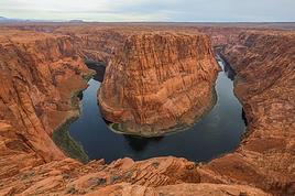
Enfin à propos de "Wahwaeap" Thierry dans son site "Ouest USA" parle de la route BLM 431 pour y accéder, quelqu'un l'a t-il parcourue récemment pour savoir si elle est toujours ouverte, si avec un 4*4 trailblazer elle présente des difficultés particulières (j'avoue que je suis motivée pour voir ces formations mais pas s'il faut faire 18km)
A tous ceux qui pourront m'aider à répondre à ces questions un grand merci d'avance.😉
Je vois que tu utilises notre site web ouestusa.fr et que tu envisages de visiter certains de mes lieux "hors des sentiers battus" de prédilection !
Pour l'accès aux Wahweao Hoodoos par la piste BLM 431 la situation n'est pas claire depuis des années car les rangers ne veulent pas que les visiteurs passent par là mais veulent qu'ils fassent la longue marche en venant du sud par Big Water. Si on demande au Visitor Center de Big Water ou à la Paria Ranger Station, ils n'indiquent que ce long accès par le sud (sans mentionner celui par la BLM 431) et si on évoque cette piste, selon les rangers ils disent qu'ils ne conseillent pas de la prendre, qu'elle va bientôt être interdite voire qu'elle l'est déjà, mais en automne 2007 ce n'était toujours pas très clair. En tous cas, il n'y avait pas encore de panneau d'interdiction avant d'arriver dans le wash lui même où par contre il y en a un (il ne reste alors que 20 mn de marche à pied facile) mais il n'est pas impossible qu'ils en aient mis un tout récemment comme ils l'ont fait sur la Old Sheffer road dans le parc du Grand Staircase Escalante. Je te conseillerais d'y aller par la BLM 431 (globalement facile à conduire par temps sec avec un Trailblazer, avec quelques trous en travers de la route à passer vers la fin) sans demander à personne et de continuer la piste si tu ne vois toujours pas de panneau d'interdiction, comme cela si un ranger te fait une remarque tu pourras faire valoir ta bonne foi.
A titre anecdotique, j'ai un interêt tout particulier pour les Wahweap Hoodos car en 1999 il n'existait que 2 photos connues de ces hoodoos (une de Michael Fatali et une autre du guide Jackson Bridges) qui gardaient jalousement le secret de ce site et cachaient le nom même de Wahweap. Laurent Martres et moi avons donc cherché à le découvrir pour l'insérer dans le guide Photographing the Southwest. L'année d'après j'ai continué à chercher sur place sans succès mais c'est finalement à distance par e-mail que j'ai fini par trouver la localisation précise via un contact local. Nous nous y sommes donc rendus avec Laurent par la longue marche du sud (ce n'est qu'ensuite que nous sommes revenus par la BLM 431) et nous l'avons inclu dans la première édition de Photographing the Southwest (en noir et blanc) avec des indications volontairement assez peu précises pour que seuls les plius motivés faisant un complément de recherche trouvent le site. Les allemands, grands amateurs de hoodoos, ont vite trouvé ce site et ont détaillé son accès avec cartes et points GPS sur leurs sites webs, du coup nous avons mis une explication plus détaillée dans la nouvelle édition en couleur de Photographing the Southwest.
Pour Coyote Buttes North, comme tu as obtenu le permis, ne te cantonne pas à The Wave mais explore un peu autour (Second Wave, Sand Cove, Top Rock...) car on y trouve d'autres formations intéressantes (même si rien n'y égale The Wave), voir photos ici.
Yellow Rock est également un site très original que je te conseille de visiter en seconde partie d'après midi pour en apprécier vraiment les couleurs.
Pour ce que tu envisages, un GPS de randonnée n'est pas du tout indispensable si tu as le sens de l'orientation et d'ailleurs pour découvrir tous ces sites hors des sentiers battus à l'époque où ils n'étaient pas encore documentés je m'en suis bien passé. Mais c'est quand même un "plus" bien sécurisant et pratique maintenant que tout le monde diffuse les waypoints GPS et en 2003 je me suis acheté exactement le même modèle que celui dont tu donnes le lien et il me fait toujours usage. C'est notamment utile pour enregistrer le waypoint où on gare la voiture et y revenir même si on a exploré tous azimuth ou après le coucher du soleil, enregistrer le tracé que l'on fait à l'aller pour le suivre à nouveau au retour, se rendre à coup sûr et directement sur une formation rocheuse particulière dont on a obtenu le waypoint avant de partir... Pour faire cela le Garmin Etrex basique et économique que tu indiques suffit mais il existe maintenant des modèles beaucoup plus performants et surtout plus polyvalents qui permettent d'y mémoriser / afficher des cartes routières et topographiques (ce que ne permet pas le Etrex basique) comme le Garmin Colorado 300.
Have a nice trip !
Philippe
www.phschuler.com et www.ouestusa.fr, pour une vision de l'Ouest en dehors des sentiers battus.
Carnet de voyage Ouest USA 2009
Merci beaucoup pour cette réponse détaillée...🙂
Dire que j'utilise votre site est un euphémisme, j'ai construit mes 2 voyages dans l'ouest à partir de ce site (et aussi des nombreux renseignments glanés sur ce forum😉) au point que je l'avais téléchargé sur mon disque dur afin de pouvoir y accéder sans connection internet quel que soit l'endroit où je me trouvais l'an dernier. Cela m'a été très utile quand des changements de programme s'imposaient, un site alentour à visiter...une balade à faire... une mine vous dis-je! et comme je n'ai jamais pris le temps de vous remercier j'en profite, je sais le temps que ça représente😕
Pour en revenir à mes questions je crois que je vais faire confiance à mon sens de l'orientation puisque tu y es parvenu, on essaiera de faire aussi bien, je trouverai bien comment dépenser autrement ces 92$.
CBN j'avais prévu comme vous le conseillez d'y passer l'après midi, histoire d'avoir le temps de visiter tout autour, pourvu qu'il fasse beau!!
Wahweap comme on arrivera de la cottonwood j'essaierai de trouver l'embranchement qui mène à la BLM 431 et puis on verra bien, je vous dirai à mon retour (si on ne se perd pas) si elle est toujours "ouverte".
merci tout d'abord pour les compliment sur notre site
Sur l'utilisation du GPS: si vous avez un excellent (pas bon, excellent), sens de l'orientation comme philippe, alors on peut s'en passer bien que c'est tout de même un gros plus par contre si bon avez un sens de l'orientation moyen, alors c'est indispensable, ce que je considère pour ma part: c'est une sécurité les modèles élaborés ont une carto TOPO intégrée qui peut aider lors d'exploration
On trouve maintenant un un tarif très abordable le e-trex vista qui m'a accompagné durant 3 ans (je suis maintenant passé au colorado 300) et qui permet de télécharger des fonds de carte topo notamment sur les parcs nationaux de lou'est incluant grand staircase escalante national monument
Envie de découvrir l'ouest autrement, de sortir des sentiers battus: c'est maintenant sur www.ouestusa.fr où vous attendent itinéraires, cartes topo, photos, moteur de recherche et de nombreux renseignements
Bon alors finalement je pense devoir passer par l'achat d'un GPS🙁, je crains que mon sens de l'orientation ne soit pas excellent ( j'entends mon mari ricanner... chercher sa voiture sur un parking ça ne compte pas 😛) et je n'ai pas la moindre envie de dormir dans le désert avec ma famille.
Quant au modèle je vais potasser la question car je n'y connais rien.
Merci pour votre conseil et longue vie à votre site
Nous avions effectivement prévu de l'acheter sur place mais 2 des 3 ballades pour lesquelles nous avions envisagé de l'acheter ne se sont pas faites, résultat nous avons décidé de tenter le coup sans GPS, excès de confiance que j'ai regretté. Je ne peux guère vous aider dans votre choix par contre je confirme le conseil de wavemaster, il vaut mieux en avoir un, car malgré toutes nos précautions nous nous sommes perdus sur le chemin du retour, pas complètement car je suis là pour vous répondre, mais nous avons largement dévié de notre route "aller" et avons connu un moment d'angoisse quand nous nous sommes aperçu de notre erreur. Par 45° et plus beaucoup d'eau les choses ne pretent plus du tout à sourire... heureusement nous étions prêts d'une rivière à sec que nous avions passé à l'aller, en la remontant nous avons pu retrouver des traces de pas nous indiquant le chemin . Les paysages sont traitres, vous pensez avoir des repères mais où que vous soyez ce sont les mêmes... et ne vous fiez pas aux cairns que les touristes ont mis, il y en a partout, même sur les mauvais chemins.
Un instant j'ai regretté de ne pas avoir suivi les conseils de wavemaster...on devrait toujours faire confiance aux pros!
Bonjour,
Nous souhaitons faire le trek de 4 jours reliant Mestia à Ushguli sans agence. Il est précisé dans les descriptifs qu'il existe des hébergement à chaque étape, mais on ne trouve pas d'info sur ces hébergements. Quelqu'un a-t-il des infos et un avis sur ce parcours?
We're planning to trek in Peru and Bolivia and would love to find some local agencies.
If you know any, could you share details on prices and, of course, the names of the agencies?
Which trek would you recommend?
Elocine
Je pars en autonomie totale sur un trek au Maroc (10jrs) Imilchil - Aghbalou.
Trouve t-on des cartouches gaz à vis (Coleman, Primus) à Marrakech (adresse) ou villages entre Imilchil - Aghbalou ?
Si non , trouve-t-on des cartouches Butagaz pour camping-gaz (petit volume 230 gr ...)
Merci d' avance pour vos réponses
Hello, I’d like to embark on a little trip in my home country, Switzerland. I’ll start walking from La Cure, heading toward Le Noirmont first, then I’ll improvise my route—but it’ll probably follow the French border... at least as far as Lac de Joux.
I’ll decide day by day how much farther to go after that. My goal is to stay in nature as much as possible, wander around for as long as I can, and restock food in villages or towns along the way.
I’m thinking of mostly camping, but we’ll see if I end up in a hotel or another campsite depending on my route.
I’d love to reach La Chaux-de-Fonds on foot... maybe even Delémont.
The whole thing should take about a week, give or take.
I’ll be bringing my dog, and I’m preparing for this as soon as I’m ready.
Any tips to make sure everything goes smoothly for us? Things I should know—or avoid? What about shepherds with their flocks of sheep? And isn’t hunting season open right now?
I’m not sure if what I’m planning is even doable, which is why I’m asking around.
This’ll be my first time doing something like this—wandering in nature *and* with a dog. I’m really excited for this adventure... and I need it. Thanks!
We’re really keen on ecosystems and want to hike in "natural" ancient forests—not planted woods or areas heavily degraded by human activity. Travel guides (like Lonely Planet) don’t provide much info on this. Could you point us to the most interesting spots?
Thanks in advance for your tips.
We wish you happy holidays and a fantastic 2026, full of discoveries!
Claire and Albert
Hi, this might not be the right section, but I’d like to know if it’s possible to start mountaineering with another person without necessarily hiring a guide. We’ve done quite a bit of hiking but not mountaineering—we’ll just do a half-day glacier course. After that, we were thinking of starting with La Grande Motte and the Pointe de la Traversière, which were recommended to us. Honestly, for things like roping up and knots, I’ll learn at home with lots of videos and a book.
Hi,
I don’t know Switzerland at all and was wondering if Vallée des Joux and especially Dent de Vaulion are packed early in the morning or late in the afternoon in July and September?
If so, do you have any quieter spots to recommend in the area, or in Luxembourg (yes, I know it’s not the same country 😉)?
Thanks a lot!
Jaimerais savoir si quelqu'un aurait fait des treks sur le Ruwenzori et combien ça coute en moyenne, les infrastructures, les paysages la sécurité sur les lieux, merci beaucoup. J'attends avec impatience vos réponses.
We’re leaving in 9 days for a two-week trip to Madeira, mainly to hike.
From my research, I’ve found that since last year, access to most trails—and systematically for the most popular ones—is now paid. You have to pay an access fee of 4.50 € per person per classified hike in 2026, and even 10.50 € for the most iconic hike: Pico Arieiro to Pico Ruivo. When paying, you also have to choose a day and a 30-minute time slot for your start time. Of course, this reservation is neither changeable nor refundable, even if the weather that day is terrible.
Personally, given the massive influx of tourists to the island in recent years, I don’t mind paying a fee to help maintain the trails. Similarly, setting a limit on the number of people who can hike them per day is certainly preferable to preserve this priceless heritage.
However, what’s much less fair is that in reality, most of the available spots are reserved: 1/ for Madeira residents (which is normal); 2/ for "economic operators" (meaning local tour operators). For example, if you’re a non-resident (independent tourist), no booking is possible for the Pico Arieiro hike for an early morning start before September! So, unfortunately, we’ll have to skip this hike.
It’s the same issue for Ponta de São Lourenço, the 25 Fontes, Pico Ruivo... in short, all the most popular hikes. Oh well, we’ll skip those too!
So my question is: which hikes do you recommend where we won’t face the huge crowds that the others get? And where we can book the day before for the next day, taking the weather into account?
Finally, a quick accommodation question: we’ve booked the first week in Funchal, but I haven’t decided yet for the second week. Do you have any advice on where to stay in the south or north, preferably avoiding overly concrete-heavy and touristy spots?
I’m reposting about the logistics for Samaria Gorge.
I’d love to get recent info, especially about whether it’s possible to park my car in Omalos, do the hike, and then catch a bus back to my vehicle.
In theory, it’s doable, but when you check the KTEL website, there aren’t any feasible schedules listed. If anyone has recently organized this with reliable, verified details, I’d really appreciate it. Thanks in advance!
Hi there,
We’re flying from Montreal to Lyon this August to go hiking in the French Alps. We’ve rented a car and will be staying at campgrounds. We’re planning to do day hikes and want to stay a few days in one spot, do a few hikes, then move on to our next camping spot. Could you share your favorite spots or any recommendations for places to spend a few days with great hikes?
A few details:
We arrive in early August and leave in early September.
We’re looking for day hikes (or shorter), moderate difficulty, with a cumulative elevation gain of no more than 1000m, and of course, beautiful scenery!
We’d prefer not to drive too much—maybe it’s best not to head too far south and deal with unnecessary heat?
Along the same lines, if you know of any great campgrounds where we can start our hike directly without needing the car, we’d love to hear your suggestions!
Bonjour
Souhaitant faire de la randonnée sur cette île, je voudrais d'abord savoir quelle serait la période la plus favorable sachant que j'avais passé quelques jours en novembre 2018 pas pour cette activité mais plus pour une simple découverte de l'île et le temps n'était pas top notamment en montagne. Donc peut on choisir une organisation en étoile sachant que je louerai un véhicule avec éventuellement 2 points d'hébergement.
Je n'envisage pas d'intégrer une structure mais de partir à 2 et de s'organiser sauf si vous me conseillez une agence locale ou un guide local. Enfin même si je compte me procurer les différents supports, carte et topo guide plus gps je vous remercie de bien vouloir me communiquer les randos à faire en priorité
Merci beaucoup pour vos informations
I’m planning to do the Mercantour crossing following the Randoxygène route in mid-July.
I’m used to hiking in the mountains, but I sometimes get vertigo, for example on ridges with drops on both sides. I wanted to check if there are any T4 or T3-T4 sections and find out if there are any very exposed passages—and if so, where—so I can plan an alternative route.
Can anyone give me some info on this?
Thanks!
I’m planning a trip around Cap Corse and the AGRIATES in 2026, from May 8th to 15th (there are still 2 spots left, by the way! Just DM me if you're interested).
I’d love to know which hikes are worth prioritizing in the AGRIATES. We’ll be staying in SALECCIA for two days as our base—what should we focus on from there?
A round trip to IGNHU beach? Any other suggestions?
For Ostricano, I think it’s too far for a round trip...
Thanks for your tips!
Have a great day,
Anie, Toulouse
I’d like to get some info about the GR10 Pyrenees traverse. I need help planning the daily stages and accommodations—my wife isn’t an experienced hiker but walks a lot, so I’d like to schedule shorter walking days and thus a longer overall trip in terms of number of days.
Could anyone give me some help and advice?
Best regards,
New to this forum, I’m planning a pretty big project for 2028.
I’m heading to Nepal to do a trek from Kathmandu all the way to Everest Base Camp (a cool 5,300 m 😄).
This trek is a bit special because even though I’ll be part of a group, I’m going solo (so far, no problem—I’m used to it). But it’s my first real trek, and it’s also a humanitarian one: once I reach base camp, I’ll stay an extra week to help clean up the waste left by tens of thousands of climbers! Since I’m originally from South America, from two countries that share the Andes, I have a deep respect for mountains—they fascinate me. So Everest… it’s kind of the trip of a lifetime!
So, a little question for those who’ve done treks to Everest before… any tips for good mental preparation (I’m already working on the physical side)?
Hi there, I’m planning the Annapurna Circuit for March 2027 and I’m looking for a local agency with a local guide—preferably French-speaking—to arrange this trek for us. Any suggestions? Thanks
Hello!
We’re spending a few days in Toraja country at the end of May. We’d love to do a day trek—taking our time—on a route that’s stunning in terms of scenery, but not a level 5 in difficulty!
Any suggestions you can share, please?
Thanks in advance
I’d like to do the Mare a Mare Sud in May over 4 days. I’ve found quite a few places to stay along the route, but I’m stuck on the start and finish.
I’ll be arriving by plane on Sunday evening and would like to start pretty early on Monday morning. Ideally, accommodation right at the trailhead (Alzu di Gallina) would be amazing, but I can’t find anything. Any tips?
Also, for the transfer from Figari Airport to Porto Vecchio or Alzu di Gallina?
At the end, I’d like to pick up a rental car—any advice on that too?
I’m traveling solo by plane to Catania in May and plan to hike the northern side of Etna, starting from Linguaglossa where I’ll arrive by bus. After that, I’d love some info on how to get up to Piano Provenzana (shuttles or hitchhiking), since it seems there’s no public transport except in the summer. Can you sleep there in a free or cheap refuge, or camp? And how far up can you go without having to hire a guide? Thanks in advance. Bernard.
Bonjour a tous,
je pars en voyage au Maroc en aout et nous allons commencer par nous arrêter a Chefchaouen(nous sommes en voiture).
Ma question: quelqu'un peut il m'indiquer un itinéraire de rando en boucle d'entre 5 et 7 jours aux départ de Chefchaouen dans le parc de Talassemtane passant si possible par le pont de dieux?Ou un guide papier qui en reunis quelques uns?
Nous privilégions le camping sauvage et les gites.
Merci d'avance
Hi there, for those who’ve been recently—is it possible to find other solo travelers in March on the island to share transport or room costs? It doesn’t seem easy to travel on a budget.
If you have any recommendations for simple lodgings or places with dorms, I’d love to hear them.
For those who’ve done multi-day treks while moving around: do you need to bring your own sleeping bag? I’d love to hear about itineraries you’ve done without a guide, just with a map and GPS.
Thanks, and have a great day!
Hi everyone!
We’re planning a 15-day road trip to Scotland this summer, specifically to explore and hike on Lewis and Harris—places we’ve never been before. We’ve visited other islands on previous road trips in Scotland (we usually go in April for a week). This would be our first time in Scotland in the summer and for 15 days. We’re looking at late August to early September.
I’m currently drafting the itinerary. We’d be crossing from Ullapool and were thinking of spending 3 nights on Harris and 4 nights on Lewis.
Does that sound balanced to you? Is it better to keep the same accommodation on Harris and the same on Lewis to explore the area? I’d love to hear about any past experiences you’ve had on these islands.
Thanks!
Hi there, I’m trying to leave for 15 days very soon to São Vicente. I’m either looking to join an agency or figure things out on my own to go hiking on one of these islands or both. From what I’ve seen, it’s not easy to organize with local transport, so it gets expensive. Can I use the services of a small local agency? I’m looking for the simplest way to hike for several days. Also, how do you get from São Vicente to São Nicolau? Thanks in advance and have a great day!
Aichatou
I’ve been wanting to do this for several years, and this year’s the one. Next September, I’ll be trekking in Tusheti (Georgia), from Omalo to Shatili.
Of course, I won’t be renting a vehicle that’d just sit unused. No problem getting to Pshaveli, but from there to Omalo, it’s a dirt road (still the case?)
There must be some form of public transport since there are so many guesthouses, and not all travelers come in a 4x4.
If any of you have been to Omalo, could you confirm that these shared transports exist and how often they run?
we’re planning a trip to Yellowstone and hoping to do a three-day backcountry hike if we get a permit.
if any of you have done this before, could you let me know if it’s possible to find water along the way? And if we can transport it, are we allowed to use a stove?
Hello,
I’ll be in Nepal from March 6th to 29th (we’re flying into Kathmandu via Varanasi and leaving via Delhi).
I’m a bit confused about the regulations requiring a guide.
My wife and I (we’re 63 and 64) aren’t experienced trekkers—we’re more used to walking on terrain with very moderate elevation changes. I’m looking for fairly easy hikes, possibly day trips.
Here are my questions:
- Does the Poon Hill trek from Pokhara require a guide, or is it better to go through a local agency? (I’ve seen a lot of them offering 4-day packages)
- I’d like to do a few multi-day hikes around Jomsom (Kagbeni, Mukitinath, Lupra, Marpha)... Do you need a guide for those, and can you find accommodations easily without booking in advance?
Last question—I’m really hesitant to lug around a sleeping bag or down jacket during our 6 weeks in India. Can you easily find these kinds of items at reasonable prices in Pokhara?
Thanks in advance for any tips you can share!
Yann