Apres une premiere traversee a velo, l'hiver dernier, du maroc jusqu'a Ouagadougou en passant par la traditionnelle route par la Mauritanie, Senegal et Mali, l'envie me vient aujourd'hui de repartir de Ouaga et de remonter vers la France, cette fois-ci en passant par le Niger et l'Algerie.
La seule portion qui m'inquiete un peu est celle entre Agadez et Tamarasset. J'ai lu plein de trucs sur le web, et je me demande en ce moment quelles sont les dernieres conditions de la route.
De plus j'ai quelques questions:
Connaissez vous l'emplacement des potentiels points de ravitaillement en eau sur cette portion du trajet? Dans quelle direction est le vent dominant? Quelle periode de l'annee serait la moins chaude? fevrier? Puis-je acheter le visa algerien a Niamey?
Merci de votre aide. Toute information sur cet itineraire serait grandement apprecie.
bonjour
je connais assez bien l'algerie faire ce trajet a velo (remonter du niger vers l'algerie) me semble tres dangeureux surtout en algerie : niveau securité niveau sechresse ....en algerie pour passer et circuler au desert il te faut absolument un guide je ne sais pas si tu connais l'affaire des europeens (allemands) qui ont été kidnapés au desert algerien . je pense que j'ai pas tout a fait repondu a tes questions mais un conseil evite l'algerie a velo!!
Quand tu dis que tu connais l'Algérie, je te demande qu'est-ce que tu connais de l'Algérie ?
Connais tu le Sud algérien et connais tu vraiment l'histoire de ces touristes autrichiens - rentrés illégalement sur le territoire algérien par le Grand Erg Oriental . L'Algérie est un pays relativement sûr. Ceux qui fraudent ainsi ne peuvent réclamer la sécurité auprés des services qui ne les ont même pas enregistré à la frontières. Au passage, c'est tout de même un de mes voisins algériens, de Ghardaïa, qui les a sorti du Mali. Et moi, je te conseille d'éviter de parler de sujets que tu ne maitrises pas vraiment.
Salutations.
La meilleure période pour traverser cette région se situe entre octobre et mars. Il y fait relativement bon la journée et froid la nuit (prévoir un bon couchage si tu as prévu de dormir à la belle étoile). Les vents, dans cette période, sont Nord Est-Sud Ouest. Attention aux tempêtes de sable. En ce qui concerne le Niger, je ne saurais te répondre trés exactement mais pour l'Algérie, saches que la route commence à partir de Tamanrasset pour aller vers le Nord. Aprés Tam, c'est trés fréquenté (bien que ce soit le désert vrai, nombreux sont ceux qui empruntent cette route). Ce qui sous-entend que de la frontière (In Guezzam) à Tamanrasset c'est une piste (450 kms environ). A In Guezzam, il y a un poste frontière et donc de l'eau. Mais pourquoi n'essayes tu pas de contacter la Wilaya (traduire Etat ou Province) de Tamanrasset qui administre toute cette zone ? Sinon Le visa se retire partout où il y a des consulats d'Algérie (particulièrement dans les capitales et les grandes métropoles). Tu peux t'en faire délivrer un sur Montréal. Je souhaite que tu puisses aller jusqu'au bout, que tu puisses réaliser, concrétiser ton ambition. Un jour - peut être - j'envisage de remonter - à pied - de Tombouctou à Reggane. En tous cas, bienvenue en Algérie.
Salutations.
re
il parait que tu as un manque de savoir sur l'algerie meme si tu visites ce pays tu na rien appris!! tu sais que le sud algerie et nord mali niger est le siege du al qaeda en maghreb? ces terrorites sont installés depuis longtemps en sud algerien nord mali et niger et faire du velo laba me semble du delire.
meme les algeriens eux meme n'osent pas voyager vers ces regions seuls!! arrete de defendre de lalgerie c'est un pays non securisé et hyper dangeruex.prend lavion direct vers alger c'est mieu ya des vols depuis niamey niger.
si tous les gars qui avaient traversés le pakistan et l afghanistan a velo s etaient retrouvés en mains d extremistes terroristes, plus personnes ne voyagerait en terre islamique...
il y a quand meme relativement bien qques touristes qui passent ds cette region, dis moi quelle est la proportion de ceux qui ont été enlevé? parce qu il y en a eu qques uns faut tout voir negatif...tristounet
Le Sud de l'Algérie, je connais bien. J'y ai de la famille un peu partout (à Mecheria, à Béchar, à Laghouat, à Ghardaïa, à Metlili, à Zelfana et à Tamanrasset) et je m'y rends assez régulièrement pour la visiter. Sinon de quelle origine es tu ? Je vois que tu es en Espagne. Je ne crois pas que tu es algérien. Il faut savoir que le Sud algérien - lieu de toute sa richesse et de sa prospérité actuelle - est trés sécurisé. Par exemple, pour se rendre à In Aménas ou juste à Hassi Messaoud, il faut absolument montrer patte blanche. Et pour cela, que tu sois algérien où étranger, tu dois te faire délivrer un laisser passer. Al Qaeda dans le Sud algérien et aux Nords du Mali et du Niger, il n'y a que ceux qui ne vivent et ne vont dans ces endroits qui y croient. Le Sud algérien et les Nords du Mali et du Niger sont l'objet de trafics (de cigarettes), aussi, je ne vois pas quels intérêts Al Qaeda pourrait viser au delà du tropique. Al Qaeda se serait établi entre le Tidikelt, le Ténéré et le Tanezrouft. Mais il n'y a rien dans cette région. Il faut être suicidaire pour s'établir là où il n'y a rien et surtout pas d'eau. Il ne t'ai pas venu à l'esprit que cette rumeur lancée par je ne sais quelle agence de renseignements occidentale, peut quelque part arranger les autorités algériennes dans la guerre féroce qui se mène autour des hydrocarbures. Il ne t'ai venu à l'esprit que cette rumeur peut arranger les autorités Maliennes et Nigeriennes aprés les répressions sauvages qu'elles ont menées à l'endroit des populations Touaregues. Il ne t'ai pas venu à l'esprit que depuis que les américains envisagent de s'établir au Nord du Mali (à Tessalit) et au Sud de l'Algérie (à Tamanrasset), l'endroit s'est vu subitement infesté par une cinq centaine de membres d'Al Qaeda. Si on veut destabiliser un pays, il faut s'attaquer à ses organes vitaux et ses centre de commendements. A plus de 2000 kms d'Alger et plus de 800 kms des champs gaziers de Aïn Salah, je ne vois pas trés bien ce qu'on peut faire. En été, la température dans la région - mis à part à Tam - dépasse allègrement les 50 degrés le jour, pour redescendre autour de 30, la nuit. Soyons serieux.
Salutations.
non je ne suis pas algerien
kelk soit tes effrots pr demontrer la securité en algerie je vais jamais en croire
l'algerie est un pays dangereux . my ex-girlfriend etait algerienne et je ne plaisante pas qd je dis evite algerie a velo
C'est bien ce qui me semblait. Tu n'es donc pas algérien et tu vis en Espagne. Mais l'Espagne, c'est dangereux ! Au Nord, il y a l'E.T.A et partout ailleurs c'est Al Qaeda. Arrête de faire l'enfant et evites vraiment de parler de ce que tu ne connais pas. Et puis le coup " my ex-girlfriend est algérienne " me rappelle trop le " je ne suis pas raciste, j'ai un ami algérien ".
Salutations.
Ta réaction sur l'Espagne prouve ce que j'ai voulu te démontrer. C'est aussi ici que notre discussion s'arrête. Je ne crois pas - à aucun moment - t'avoir manqué de respect et déjà tu m'insultes !
Salutations.
Bonjour,
J'ai bien peur que tes premiers intervenants ne se soient un peu égarés dans des débats "politiques" . Ma derniere expèrience sur cette route (à moto) date d'il y a quatre ans, mais je peux quand même te donner quelques infos, peut être à vérifier via un consulat Algerien .
La sécurité : pas de risques si on reste à proximité de l'axe principal . Hors le probléme bien particulier du groupe en hors piste au nord de Djanet, seuls quelques touristes s'étant aventurés dans des vallées isolées de l'Aïr (Niger) ont eu à souffrir de faits de brigandage : vol de l'argent, des papiers, et surtout de la Toyota !!! . A vélo, tu serais bien incapable de t'y rendre, et je doute que tu interresse les brigands locaux avec ton vélo 😛 . L'Algerie est aujourd'hui pacifiée .
La piste : 600 km, exclusivement de sable plus ou moins mou entre Arlit et 200 km au nord de In Guezzam (400 km quand même🙁), puis de plus en plus "dure", mais tolée au fur et à mesure que l'on pénetre dans le Hoggar . Pas de point d'eau sur la piste, hors Assamaka et In Guezzam . En été, températures infernales vers In Guezzam, puis au nord de Tam., en particulier dans la cuvette de In Salah . Températures convenables en Hiver en journée, mais vent du nord assez soutenu (donc de face) .
Point à vérifier : une route était en construction entre Tam. et In Guezzam, mais très peu avancée à l'époque . Je ne sais pas où elle en est aujourd'hui . Au mieux, il ne resterait que les 200 km de piste entre In Guezzam et Arlit, mais ce ne sont pas les meilleurs !
Vent de face, pas d'eau, et beaucoup de sable, ce n'est pas très engageant pour le vélo . Ceci dit, j'ai rencontré à Ndjamena un Italien qui l'avait fait à vélo, mais dans le sens Nord-Sud, dans les conditions suivantes :
Etapes moyennes de 60 km
Nourriture et eau déposées par des voyageurs complaisants tous les soirs
Problème : il y a à ma connaissance moins de traffic touristique (ou assimilé, type descente de véhicules d'occasion pour vente en Afrique) Sud-Nord que Nord-Sud . Par exemple, j'ai passé trois jours au camping d'Agadez sans voir un seul touriste partant vers le nord . Donc la mise en place d'une telle logistique parait difficile . Quant à transporter dans le sable nourriture et eau pour 7 jours plus réserves de sécurité ....
Donc à toi de voir . Une option est de mettre vélo et cycliste dans un camion pour les passages les plus difficiles, mais ils sont en général surchargés et les conditions y sont aussi très éprouvantes
Jean-Marc
NB : les Algeriens et Nigériens, en particulier ceux du Sahara, sont très gentils et très accueillants, mais le désert est rude, et quand on a besoin d'un service "commercial", il peut être très cher .
Un brin de folie est comme l'argent: ça ne fait pas le bonheur, mais ça aide!
Je me suis un peu égaré - comme tu dis - mais il me semble qu'il est parfois nécessaire de faire une mise au point. Qu'une personne réponde trés justement à une question c'est - je crois - un minimum. Hors, ici, un type se met à mentir sur des endroits qu'il ne connaît pas (le Nord Niger et le Sud de l'Algérie) dans le seul but de nuire. Et c'est particulièrement facile lorsqu'il s'agit de l'Algérie. Ceux qui n'y ont jamais mis les pieds, et qui tombent sur ce genre de commentaires sans savoir que l'auteur n'y a jamais - lui même - mis les pieds, peuvent aisément être dérouté.
Salutations.
Merci a tous pour les réponses pratique et politiques!!!
Je ne suis pas encore convaincu de partir faire cet itinéraire et vos réponses éclairées me font réfléchir. Car si en plus de la chaleur, de la piste pleine de sable il n'y a même pas de camp d'entrainement d'AlQuaeeda pour me divertir, ca risque d'etre très ennuyant comme voyage....
bonjour, entre Agades et Tam, tu trouveras des points d'eau sans probleme, le pus difficile à velo ce sera la portion entre Arlit et Assamakar (poste frontiere) c'est bien sableux par là mais faisable malgré tout. Le mieux serait que tu te fasses aider par des 4x4 ou camions qui empruntent la route souvent.
Donc pour les points d'eau : arlit puis entre Arlit et la frontiere il doit y avoir un ou deus villages (au pire il ya toujours un campement dans les parages) puis après la frontiere, tu tombes sur In Gezzam, bled bien glauque mais ou il ya de l'eau. Ensuite la portion pour rejoindre Tam n'est pas des plus agreables mais bon, c'est le trip qui compte!! (la par contre pendant troiscents KMS pas de village...)
les periodes les mieux c'est octobre, novembre débt décembre, puis à partir de février (avant ça caille!!)
sinon moi je te conseille de prendre le visa alérien avant de partir, je ne sais pas trop ce que ça donne à niamey. mais c'est toujours compliqué avec les algériens et s'il te manque un papier ce sera un peu con.
voila si tu veux d'autres infos n'hesites pas
PS : je ne suis pas sure non plus qu'on te laisse aller seul à vélo en Algérie, renseigne toi la dessus car nous quand on descend en voiture on a toujours un guide touareg avec nous (je suis mariée avec un touareg alors c'est pas un poblme pour nous)
SVP arrêtes de raconter n'importe quoi n'importe comment ici ! En plus, tu t'adresses à la mauvaise personne, lui (El Meniaa) disant qu'il ne connait pas son propre pays où il réside très souvent, en plus dans le Sahara (Ghardaia et El Golea)...
Je suis une femme, française, installée à El Golea, je circule librement dans tout le Sahara, je ne suis pas kidnappée.... ni coupée en petits morceaux.... Et ce n'est pas les km qui me manquent à mon palmarès...
La Nationale 1 est très fréquentée aussi bien par des algériens que par des étrangers.... seul ou accompagné... relativement peu de barrages, des survols hélico pour les trafiquants de cigarettes/drogues dans l'extrême sud... et aussi dans le Grand Erg, mais cela s'arrête là !!!
Et que fais-tu des milliers de touristes qui fréqentent le sud et l'extrême sud ???? Même il y a des agences françaises qui font des raid hors piste de 10 jours (récemment sur un tronçon jamais fait et inconnu en reconnaissance en vue de le mettre en catalogue !)....
Alors le hyper dangereux, ca serait bien de mettre ces propos ailleurs, une membre VF s'est amusée à faire uen enquête de tous les attentats en Europe et dans le monde avec dates et lieux.... c'est plus qu'angoissant, et l'Algérie y figure à peine !!!
N'oublies pas le grand nombre d'investisseurs algériens ou étrangers (petits ou grands) qui commencent à s'intéresser de plus en plus à l'Algérie, et surtout le sud !
Alors ne parles pas des choses que tu ne connais pas SVP !
Merci
Lili
Il n'y a personne qui soit née sous une mauvaise étoile, il n'y a que des gens qui ne savent pas lire le ciel. (Dalaï Lama)
mais rien ni personne ne vient à bout de ceux qui défendent une cause juste... (Mano Dayak)
Je te déconseillerai de faire cette route en vélo, surtout la partie algérienne, non pas à cause de l'insécurité (voyous ou terroristes...) mais à cause du manque d'eau et les fortes chaleurs qui y règnent... En cas de pépins tu seras trop seul et isolé !!! Une partie de la route est une piste... pour un vélo pas ce qu'on fait de mieux !
réfléchis bien...
Lili
Il n'y a personne qui soit née sous une mauvaise étoile, il n'y a que des gens qui ne savent pas lire le ciel. (Dalaï Lama)
mais rien ni personne ne vient à bout de ceux qui défendent une cause juste... (Mano Dayak)
Bonjour
quelles sont les moyen les plus simple pour revenir du Cap Nord sans pédaler
train, Bateau, avion ?
qui à déjà fait l’expérience ?
Merci de nous renseigner
17 days, 1,400 km, and 17,500 m of elevation gain cycling in northern Vietnam! 🇻🇳 🚴🇻🇳
From the misty Fansipan to the breathtaking landscapes of the Ha Giang Loop, from remote villages to vibrant markets...
I cycled through the north of the country, getting up close with its people—through mud, heat, endless mountain passes, and unforgettable encounters.
Most importantly, I discovered a Vietnam far different from the usual tourist circuits.
Join me on this adventure through a video that captures these 17 days of travel. :)
If Vietnam calls to you, come ride a stretch with me!
Bonjour,
Je dois arriver en vélo à Thessalonique à la fin Septembre et je prévois de rejoindre Istambul par la côte.
Quelqu'un pourrait m'aider à choisir la meilleure route.Sécurité, difficulté.
Merci d'avance.
Marc
Hi,
can anyone give us some tips on how to get to North Cape from Lyon Gerland?
What’s the best route to join the EuroVelo 7?
How many kilometers is it from Lyon to North Cape via EuroVelo 7?
The best month to leave—we’re thinking early May.
Thanks for any advice!
Looking for a female travel companion for a cycling trip (arriving by plane in Porto Alegre, Brazil, and cycling toward Montevideo, Uruguay, returning by plane to France from Buenos Aires, Argentina) – 1,500 km
Hello everyone!
I’m planning a cycling trip across Brazil, Uruguay, and Argentina, with a departure set for late October, November, or December. I’m looking for a travel companion to share this long-distance adventure with.
Experience:
I already have solid experience in bicycle touring in Georgia, Kazakhstan, and Kyrgyzstan. Currently, I maintain excellent physical condition by cycling an average of 250 km over 3 days per week (4 hours a day at 20 km/h).
The trip & the pace:
Daily pace: Between 50 and 80 km per day, to make steady progress while taking time to explore.
Accommodation: Flexible and authentic. We’ll alternate between wild camping, campsites, Warmshowers, small guesthouses, and budget hotels depending on opportunities and the weather.
Looking forward to reading your message and planning this amazing journey together!
I’m planning to leave Nice for Toulouse around 10/15 and I’m looking for tips / great deals regarding:
- The route: I was thinking of taking Nice - Grasse - Draguignan - Salernes - Cadarache - Cavaillon - Arles, then the Camargue, Sète, and the Canal du Midi to Toulouse. The idea is to avoid high-traffic roads and too many steep climbs. Are there any spots to avoid or must-see stops? Since it’s been a while since I’ve been on the road, I was thinking that sleeping indoors might be preferable. If you have any budget-friendly accommodation suggestions along part of the route, don’t hesitate!
Thanks in advance, and if you’re in the area around that time, we could ride together... Ciao.
Another long-time dream of Claudio’s: the Petit Mont Cenis pass and the dam at the eponymous lake.
A place where many Italians, including my father, worked in the 1950s–60s.
Faverges → St-Michel-de-Maurienne → Lanslebourg → Petit Mont Cenis → return. 315 km, 3 days. Bivouac at St-Michel-de-M.
Brouter link
Leg One: Faverges → St-Michel-de-Maurienne
Leg Two: St-Michel → Lanslebourg → Mont Cenis Lake → St-Michel
Leg Three: St-Michel → Faverges
And it finally happened in August 2026: in the Maurienne Valley about the famous cycle route known as the V67
🇷🇼 Cycling in Rwanda: 4 episodes, an off-the-beaten-path adventure
After 3 weeks and nearly 1,200 km by bike across Rwanda, I made 4 videos to share this adventure in a different way: the landscapes, the encounters, the villages… but above all, all those incredible scenes of everyday life.
The 4 episodes are available here:
👉 https://www.youtube.com/playlist?list=PLGnfbxjccWAg
The 4th episode focuses on rural Rwandan life: simple, authentic, and sometimes surprising scenes that you only truly discover when you take the time to travel by bike.
If you have a few minutes, let yourself be transported to Rwanda…
Hi, I'm looking for info on cycling to Nordkapp via the EuroVelo 7. Has anyone done it already, and where’s the best place to start the EuroVelo 7?
Thanks
Hi,
We bought the MSR bike tent model (2-person + large awning that can fit 2 bikes) back in 2005. It’s served us really well, especially during a year-long trip in Africa. Now, one of the poles is broken, and we’d love to replace it since that’s the only issue with the tent—we still love it! The poles are 9.35 mm in diameter, with 8 sections of 49 cm and 2 sections of 28 cm. Total length when assembled: 416 cm. Actually, two large sections are broken: one straight and one curved. It’s a pain to find replacements since this model is no longer sold anywhere.
Would anyone have this model lying around unused and be willing to sell me a pole?
Hi everyone,
In early April, I’m redoing the Vélo Francette (La Rochelle to Ouistreham), and then I’d like to cycle along the Cotentin Peninsula (which I don’t know at all), follow the coast up to Cherbourg, and then head back down to at least Saint-Malo. I’d love to know if it’s pleasant for cycling—are the roads nice? Not too windy? What are the must-see spots? Any great campsites? All your tips and advice are more than welcome, and I thank you in advance.
Hi there,
I’m planning to bike to meet some friends in Côte d’Ivoire in early November.
I’ll be starting in Abidjan and heading to Abengourou, which is close to the Ghana border.
I’d like to take the trails. Does anyone have recent info on eastern Côte d’Ivoire?
Any tips, safety advice, or must-see stops? I’m open to all suggestions.
Thanks in advance for your help!
Fx
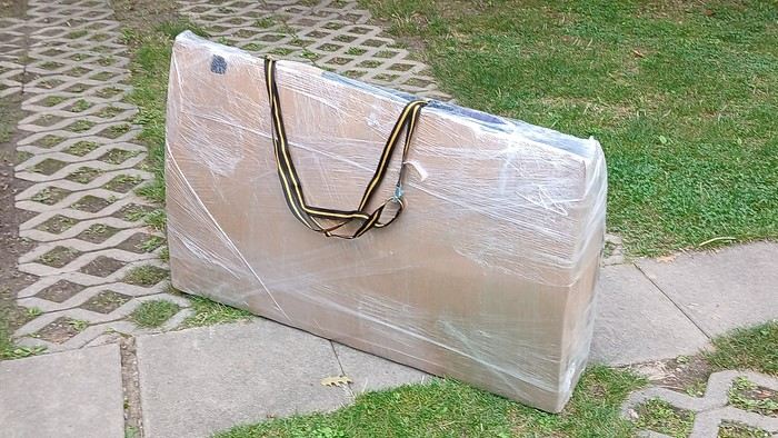
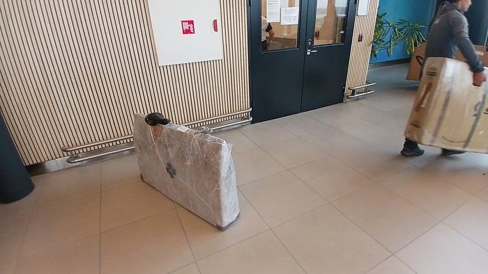
After testing it for three years across various modes of transport, I’m sharing this video of a bike packing case. It’s made from recycled cardboard and shrink-wrapped, with adjustable thickness and added bubble wrap depending on the level of protection you want.
Installing spacers at the fork and chainstays makes the packaging compact. With the fifteen-odd euros for shrink-wrapping at the airport, this case travels really well.
https://youtu.be/_GDJi-GqmkM
- Low bulk (1.10m x 0.70m x 0.25m for a large frame), it fits vertically in train luggage compartments and the total dimensions (x+y+z) don’t exceed 2.40m.
- Two carrying solutions for public transport and easy handling by airport staff (no more tears in the cardboard from openings).
- Discreet packaging when dealing with bus drivers and train conductors, as it looks like an ordinary parcel.
- No need to return to the starting point to retrieve the case from your outbound trip, which you’d otherwise have to store somewhere, or deal with a bulky cover to pack in your panniers.
- You can still check tire pressure through the plastic film without damaging the packaging too much.
Drawbacks: Around 3 hours for this lengthy and meticulous process—removing the wheels, pedals, handlebars, and derailleur without misaligning them, then securing all components to the frame.
If you get a chance to test it, send me your feedback for future improvements.
I just took a trip in Tunisia from Tozeur to Douz, skirting Chott el Jerid to the south. I’m back with the urge to keep going further south via the 4x4 tracks to connect Douz to Ksar Ghilane. Has anyone driven this route recently or explored southern Tunisia?
Thanks for your tips!
fix
😎Fellow traveling cyclists or not, all of you who love travel, the pleasure of physical effort, nature, beautiful machines, people with true passions they seek to fulfill, and who also enjoy reading great literature about all this—the *200* magazine is for you just as it is for me. I should mention I have no financial or other interest in this (in an era where we accuse our politicians of all sorts of vile interests, I prefer to take precautions). I’ve been subscribed since the beginning, and every three months, I get my 130 pages of dreams (the magazine just went from 110 to 130 pages).
It covers everything from the trans-America route to the TCR (Trans Continental Race) from Belgium to a small town in Turkey, with mind-blowing averages—4,000 km and 80,000 m of elevation gain in 8 days and 15 hours for the winner. Let that sink in, and all of it without assistance—accepting a patch could penalize you. There’s also a story about crossing Iran, encountering one of the world’s most welcoming populations, following in the footsteps of Nicolas Bouvier, as well as retirees leisurely traversing France. The common thread in all these stories? Beautiful writing. Take, for example, a stunning article: *"Passengers of the Cold: From Edinburgh to Thurso, at the very north of Scotland, 550 km of moors, coasts, and icy wind. In Thurso, the road ends at a quay, facing the Orkney Islands. We wanted a November trip, off-season. We wanted to surprise winter. Just before the snow."* A sublime piece on the experience of facing adversity and the chance encounters along the road and in the elements.
Before I embarked on my own bike trips, I dreamed a lot about them—from the Atacama to the Gobi, along the Mekong, and not forgetting France. And now, these 130 pages every quarter keep those dreamy vibes alive through stories written in the most beautiful prose.
I’ll stop here because it might sound like I’m advertising, but if you don’t know *200*, I invite you to discover it. It’ll give you wings for the most incredible challenges or simply reinforce your desire for slow rides with your eyes open to others and nature.
A little news to wrap up: Axel Carion and a friend just broke the record for crossing South America from Colombia to Ushuaia in 59 days. On its own, that doesn’t mean much, but I can’t help it—it makes me dream. You should see how he talks about it, the flashes of that wild nature he’s stored away: a snowstorm at Paso Jama and the surreal sight of the suddenly snow-covered Licancabur!
Luc
PS: The magazine is called *200* because a day’s ride starts at 200 km—well, I’ve never done a ride like that since my longest was 167 km (with 18 kg of luggage, mind you), but why not one day? The magazine will explain how to tackle your first 200, and then the question in conclusion: when will you do your first 300?😏
I’ve got my flight ticket sorted—departing in mid-November and returning in mid-March. I’ll arrive in Santiago and leave from Buenos Aires.
I’ve already been to southern Argentina, specifically Torres del Paine National Park, and I’d love to go back to do the full W trek (I only did the shorter version last time).
I also want to do some hiking and maybe even tackle a summit. I climb and occasionally do some mountaineering, so I’ll definitely be going with a guide.
I plan to start around Temuco in Chile, with the idea of heading toward the lakes, then taking the Carretera Austral.
I’m not sure if I’ll go all the way to Ushuaia—it’s supposed to not be *that* worth it, except for the bragging rights of saying you’ve been to the end of the world.
I saw there are lakes in Argentina too.
I don’t have a precise itinerary, but what I’d love is, once I reach the southernmost point of my trip, to take a mini-cruise to see some wildlife. Any tips for that?
What kind of sleeping bag did you take? Is a 0°C (32°F) one enough?
And one last question: white gas stove or can I get by with my gas stove?
I'm developing a free and open-source web app for planning walking and cycling trips (and even car trips). You can create a route by clicking directly on the map to add waypoints, and it can consist of multiple stages. The app provides tools to edit the stages and the overall route, and to display useful information (distances, altitudes, and elevation changes). A relief profile can be shown as a graph for a specific stage or the entire route.
Once the route is ready, it can be exported as a GPX file, which can then be used with a GPS or a mobile navigation app.
The app is built in JavaScript and runs entirely in the web browser. It uses the Leaflet library and several OpenStreetMap-based services. Initially developed for my personal needs (I enjoy hiking and cycle touring), I’d be happy to share it with anyone who might find it useful. It’s free to use, doesn’t require an account, and the source code is available.
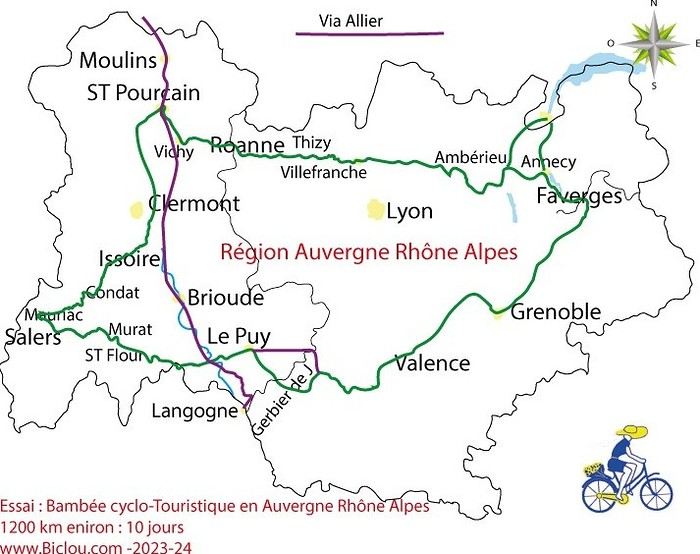
hello fellow cycling enthusiasts
here’s a travel journal of the cycling tour through the Rhône-Alpes Auvergne region by Claudio
zouli
it was the plan
http://cbandiera.free.fr/parcours/auvergne-Ralpes/
the trip was completed
story being posted online soon
1100 km in 11 days
beautiful and varied regions
Hello,
We’d like to go on a 3- to 4-month bike trip starting in December, crossing from Assam (northeast India) to New Delhi via Nepal.
Are there routes with light traffic along the Brahmaputra and through Nepal?
We’re also looking for any info on accommodations, wild camping, local interactions, etc.
Thanks,
Michel
I’m planning to cycle from Morlaix to Brest (via Roscoff and the V45 coastal route). We’ll start riding on August 16th for 13 days (with stops for island visits, surfing, etc.). Is there a lot of traffic at this time of year? I’ve got two kids, 11 and 13, and we don’t like riding in the middle of cars (we’ve already done the Vélomaritime—Caen to Cherbourg—the Loire route from Orléans to Saumur, the Vélodyssée from Nantes to Royans, and the canals like the Nivernais and Bourgogne, where there were plenty of bike-only lanes, which isn’t the case on this route).
Thanks for your help if you’ve already done this route in late August!
Virginie
Hi there,
I’ve been road cycling for several years, and I’m about to switch to gravel in the next few days—I’m waiting for my bike, which should arrive this week.
I’m planning a bikepacking trip in a few weeks along the Véloroute V81, also known as the Vélosud, from Biarritz to Le Barcarès.
Has anyone here already done this route? Any info is welcome, whether it’s about the route itself, gear, or accommodation. I’ll prioritize staying with locals as much as possible. On that note, I just signed up for the brand-new site *Guidon et Couette* ((www.guidon-et-couette.fr)), which offers free accommodation between cyclists across the country, but there’s almost no one listed along my route!
Thanks in advance.
Laurent.
Hi there, I’m planning a cross-Canada bike trip, and I’ve got a question that might seem silly, but could someone tell me how to pack a bike (in a box, with a fragile sticker... I don’t know) for a flight? Thanks in advance!
This summer, we’re planning to cycle along the EV 19 that follows the Meuse River from Langres all the way to Rotterdam.
My question is about getting back to Nantes.
Do any of you know what the best return option might be? I’d love to hear about your experiences.
I saw that FlixBus doesn’t take bikes.
By train, I think it’s possible but would involve multiple local trains.
We were also wondering if there’s a boat from Rotterdam to Saint-Nazaire that could take passengers with bikes.
Any tips or experiences you can share would be really helpful—thanks in advance!
Have a great evening
I’ve gotten used to crossing Europe by bus to return by bike.
It was really convenient to take the bike without having to disassemble it.
But FlixBus no longer accepts bikes...
What alternatives do you know about?
Thanks.
Hi there,
I’m planning to ride the Dutch section of the EuroVelo 19, from Maastricht to Rotterdam.
Since it’s too complicated to bring my bike on the train, I’m looking to rent one locally.
I’d love any tips or bike rental shop recommendations—I’m struggling to find options even in Rotterdam.
The plan is to rent in Rotterdam, take the train to Maastricht with the bike, then cycle back to Rotterdam.
Thanks in advance for any advice or suggestions!
Nath
I’m planning to build a new touring bike.
I want to prioritize lightness.
That said, I’m tempted by a suspension fork that could offer some comfort on rougher roads.
The recent appearance of gravel suspension forks on the market might meet my needs—at least on paper.
I’m particularly considering the RockShox Rudy Ultimate XPLR fork.
Unlike MTB forks, its travel is short: either 30 mm or 40 mm.
It weighs 1400 g, which is 400/500 g more than a steel fork.
Any thoughts or real-world feedback on this?
I’m also wondering about the durability of magnesium (lower leg) for long-distance bike touring.
And what’s the impact of skipping the manufacturer-recommended maintenance every 50 and 200 hours? That’s bound to happen on a long trip unless you carry extra gear.
More generally, how reliable are these kinds of forks?