Bonjour
Je cherche à faire une randonnée sur plusieurs jours en Espagne (niveau moyen) mais avec la possibilité de bivouaquer .
Existe t-il des randonnées qui le permettent ?
Merci
Bonjour Mike
L'Espagne est grande et multiple, le nord, le sud, moyenne montagne, haute montagne ????
Il faudrait également connaître la saison à laquelle vous souhaitez partir.
Avez vous consulté Wikiloc ?
Avec le menu, à gauche de la page, vous pouvez sélectionner votre activité (rando, VTT etc...), la difficulté, la distance, en boucle ou non, la région, la ville etc...
Voici le lien vers l'Andalousie, mais vous pouvez regarder toutes les régions :
fr.wikiloc.com/itineraires/randonnee/espagne/andalousie?d=1
Bons préparatifs
Ski-Addict
Le véritable voyage ne consiste pas à chercher de nouveaux paysages, mais à avoir de nouveaux yeux
(M. Proust)
Par ex dans les Pyrenees le parc national d'Ordesa, et un peu plus au Sud la Sierra de Guara:pour moi les 2 tops de la rando en Espagne. Lebivouac est permis mais reglemente dans le PN Ordesa. Sierra de Guara c'est interdit (comme a bcp d'endroits en Espagne) mais bon ... c'est possible.
Bonjour Génal
je te remercie pour ta réponse et pour le lien sur les randonnées en Andalousie
D'après ce que j'y ai lu, il vaut mieux donc choisir de prendre pour base une ville pas loin de la sierra (Ronda ou El Choro Antiquera ) et de faire une boucle et rentrer le soir au village.
C'est à dire ce n'est pas comme en France ou on peut marcher plusieurs jours sur les chemins en trouvant un refuge ou en bivouaquant (c'est ce qu'on fait ici dans le Mercantour jusqu'en Italie, en Corse (Gr20 ou Compostelle ou Pyrénées).
Donc je partirai sans ma tente. C'est dommage car j'adore dormir en pleine nature etc...
Merci bien
Bonjour Wilemspie
Super la sierra de Guara, que je ne connaissais pas et les possibilités de paratiquer le canyoning . Pas de bivouac mais sais tu s'il y a un camping ou un refuge dans ce parc et de faire les randonnées à partir de cette base. Pour y aller en avion le mieux est de se poser à Barcelone ?
Mon soucis est la logistique, car je n'aime pas forcément faire de boucles et rentrer sur une base le soir.
mais bon en Espagne il n'y aurait pas le choix...
Merci bien
Bonjour Génal
je te remercie pour ta réponse et pour le lien sur les randonnées en Andalousie
D'après ce que j'y ai lu, il vaut mieux donc choisir de prendre pour base une ville pas loin de la sierra (Ronda ou El Choro Antiquera ) et de faire une boucle et rentrer le soir au village.
C'est à dire ce n'est pas comme en France ou on peut marcher plusieurs jours sur les chemins en trouvant un refuge ou en bivouaquant (c'est ce qu'on fait ici dans le Mercantour jusqu'en Italie, en Corse (Gr20 ou Compostelle ou Pyrénées).
Donc je partirai sans ma tente. C'est dommage car j'adore dormir en pleine nature etc...
Merci bien
Ce n'est pas vrai ... tu peux partir au moins 15 jours en Sierra Nevada en Andalousie ...
Il faut respecter les règles et les balisages de protection du Parc Naturel
Soerre de Guara: en outre au canyoning, c'est genial aussi en rando. Il y a des campings et gites autour du parc. Egalement, il doit etre permis de dormir dans les nombreux villages abandonnes et ruines. Barcelone non tres loin. C'est Saragosse.
Salut
Merci pour ta réponse
Aurais tu un itinéraire qui permette de le faire avec refuge ou possibilité de bivouac ou camping à défaut ?
Merci bien
Salut,
C'est à toi de faire et de choisir l'itinéraire qui te convient le mieux ...
Tu n'en dis pas beaucoup dans ton message initial 🤪
Ni région, ni saison, ...
Je sais que je t'ai donné des renseignements en espagnol (désolé) mais quand on veut du "détaillé", c'est le plus souvent ainsi (parfois en anglais), rarement en français sauf avec guides.
Les sites gouvernementaux ou ceux des différentes régions d'Espagne sont généralement bien détaillés surtout pour conserver la protection des parcs nationaux ... C'est pourquoi, les refuges y sont entretenus et les lieux de bivouacs réglementés.
Fabriz a raison, on peut très bien faire des randos et trecks sans avoir besoin de faire une boucle.
Sur le site Wikiloc, il suffit de sélectionner, à gauche de la page, "en boucle" ou "à sens unique".
Personnellement, j'adore Ronda, on peut parfaitement partir de cette ville et se diriger vers la Sierra de Las Nieves (Pico de Torrecilla, presque 2000 mètres d'altitude) ou vers la Sierra de Grazzalema.
Certains disent que quand on ne peut pas visiter Séville, on peut en avoir un avant gout en allant à Ronda, ville la plus romantique d'Espagne selon Hemingway. Ainsi on allie, culture, ambiance et nature.
Mais, évidemment, il y a bien d'autres possiblités : la Sierra Nevada, la Valle del Guadalhorce, les Sierras de Tejeda et Almijara etc....
Ski-Addict
Le véritable voyage ne consiste pas à chercher de nouveaux paysages, mais à avoir de nouveaux yeux
(M. Proust)
Oui je souhaite partir fin juillet début aout sur une période de 10 jours.
Je vais donc tenter l'aventure en partant de Ronda. Mais après cela risque d'être l'incertitude pour se loger...
Je te remercie bien pour le site gouvernemental que je vais "éplucher"
Bonne soirée
Très intéressante ta référence à Hemingway, car en plus j'aime beaucoup cet auteur qui s'est battu pour la cause républicaine pendant la guerre et qui en plus a conçu des œuvres immortelles.
La culture cela fait toujours du bien, cela aide et je t'en remercie.
Et en plus cela donne mille fois plus envie de découvrir cette ville "romantique"
je vais consultér les lieux que tu me conseilles.
Merci et bonne soirée
Randonner en Andalousie en plein été, pas évident ou alors cela risque d'être limité, en terme d'horaires, très tôt le matin ou en toute fin d'après midi, car il fait très très chaud dans les terres.
Autre solution : monter très haut dans la Sierra Nevada. Il peut faire plus frais : par exemple, dormir une nuit au Refugio Vivac, La Carihuela (altitude : 3205 mètres). Dans ce cas, si vous voulez allier une activité culturelle, ce sera de Grenade (magique) qu'il faudra démarrer votre périple.
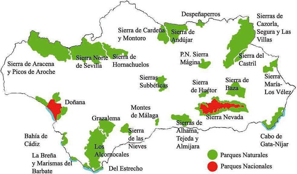
Pour vous aidez à choisir un parc naturel, vous pouvez regarder les photos de ces parcs sur le site suivant : un parc = un album photos (en plus, il n'y a ni pub, ni lien commercial) :
Photos Andalousie
Je joins également une carte des différents Parcs naturels
Bons préparatifs
Ski-Addict
Le véritable voyage ne consiste pas à chercher de nouveaux paysages, mais à avoir de nouveaux yeux
(M. Proust)
Tout à fait d'accord avec le message précédent. Pour randonner fin juillet-début août en Andalousie, il n'y a que la Sierra Nevada, en montant suffisamment haut. Car les températures à l'ombre peuvent facilement monter à plus de 40° l'été dans l'intérieur (sur la côte il fait un peu plus frais). Et le matin, dès 9 ou 10 heures, il fait en général plus de 30° aux altitudes inférieure à 1500-2000m.
Donc en plein été, c'est soit la Sierra Nevada, soit le Nord de l'Espagne (Pyrénées, ou Picos de Europa, par exemple). Et en Sierra Nevada, à ma connaissance, il est possible de bivouaquer (mais attention à l'eau l'été: il n'y en a pas beaucoup et les sources sont souvent à sec).
Pour la randonnée en Andalousie, les meilleures saisons sont le printemps et l'automne, car il fait beau et les températures sont extrêmement douces.
En ce qui concerne la Sierra Nevada en été, comme dit précédemment, il faut monter très haut, et c'est un peu "pelé".
En revanche, c'est beaucoup plus joli au printemps, quand on ne monte pas trop haut (il y a encore de la neige sur les sommets), que la végétation est en éveil ou à l'automne quand les forêts se couvrent de pourpre.
Photos Sierra Nevada été et hiver
Par conséquent, en été, effectivement , je conseillerais plutôt le Nord de l'Espagne.
Ski-Addict
Le véritable voyage ne consiste pas à chercher de nouveaux paysages, mais à avoir de nouveaux yeux
(M. Proust)
certes la Siera de Guara est belle et attractive mais il y a un monde fou en aout même pour ceux qui ne font pas du canyoning et pas facile de s'y loger!
Non c'est faux. Sur les sentiers de randonnee il n'y a pas beaucoup de monde, et meme dans certains canyons moins visites. Il y a nettement moins de monde qu'ailleurs, Ordesa par ex.
Mais oui c'est ce que je dis. Il y a moins de monde sur les chemins a la Sierra de Guara qu'a Ordesa ou a Benasque ou dans les Pyrenees Francaises ou dans les Alpes.
pour ce qui est du nord de l'Espagne tu pourrais aussi faire une partie du GR11 le sentier de randonnée qui parcourt les Pyrénées du côté espagnol et qui fait le pendant au GR10 qui lui, est du côté français ;
Possibilité de bivouaquer près des refuges . Pour aller d'un ville à l'autre à l'aller comme au retour , il y a des lignes de bus
Bonsoir
Merci "cittr21 et Génal" pour l'avertissement concernant la chaleur et il est est vrai que monter à 2500 mètres pour marcher dans la fraicheur me parait trop technique pour moi.
Zhara.
Pour le GR11 qui parcourt les pyrénnées du côté espagnol, il faut partir de quelle ville?
Existe t-'il une carte type IGN randonnée pour cette randonnée Quel est le niveau de cette randonnée (dénivelé)
Merci bien
Bonjour,
Je suis également à la recherche de belle randonnées itinérantes à faire en Espagne, mais je suis plutot intéressé par les Pyrénées!
Connaissez-vous le parc Aigüestortes i Estany de Sant Maurici ??
oui je connais il est magnifique
pas possible de bivouaquer mais il y a de beaux refuges
tu dois pouvoir tout savoir en cherchant sur Internet
bonnes balades
Par pas possible de bivouaquer il veut dire interdit de bivouaquer. C'est possible.
C'est beau aussi, mais comme ecrit plus haut pour moi le top c'est le PN Ordesa et SIerra de Guara.
Bonjour si ça peut vous aider j'ai mis des cartes des parcs naturels en Andalousie sur mon blog de voyages , je vous conseille la Sierra de Cazorla c'est pas mal du tout comme coin . Perso j'avais tenté une petite rando dans la campagne de Ronda mais à chaque fois les sentiers aboutissaient nulle part , ils étaient sans issue et arrivaient dans un champ privé mais je n'avais pas encore les cartes du coin à cette époque 🙂 .
Je rentre de la sierra de Cazorla , Segura y las villas ..ouf c'est long à écrire 😎 , je te conseille une belle rando de trois jours où l'on peut bivouaquer n'importe où. Celle qui part de la naissance du rio ségura , ( village de Pontones dans la sierra de ségura ) et qui traverse tout le parc . Profitez en pour faire une halte au chiringuinto à coté de la source et de son eau bleue translucide, c'est superbe . Mi Juin le temps était excellent , on reste à des hauteurs de plus ou moins 1800m , pas de problème de chaleur . On peut ainsi atteindre la naissance du Guadalquivir . En se servant des cartes de Padrino ça doit être aisé de te repérer . Sur place on peut trouver des cartes détaillées .
Bonne rando,
Une petite halte tranquille au bord d'une lagune vers Don Domingo
Bonjour
Merci pour le retour
Logistiquement d'où es tu partie pour cette randonnée ?
Trouve t'on de l'eau sur le parcours ou refuges etc villages pour dormir et manger?
Merci
Tu part du village de pontones , il y a le GR qui y passe , logement et un très bon resto le meson de Pontones . Ensuite tu te dirige vers Fuente ségura début du vrai chemin sans asphalte. Tu as un peu une possibilité d'eau à Don Domingo (une dizaine de kms, ensuite attention des refuges de bergers mais peu d'eau . Donc compter sur ses propres forces ou demander aux bergers , ensuite tu trouveras la nava de San Pedro et la nava de San Pedro ( fontaine ) et petit hôtel rural à la nava de san pedro ( 2 maisons , l'hôtel et le centre de réintégration des percnoptères . Mais le mieux serait de voir sur le net et avec la carte de Padrino tu te donne une idée . C'est une sorte d'Altiplano ou tu rencontreras aussi des daims (intégrés au début du siècle dernier) des chèvres hispaniques ou bouquetins et les grands troupeaux de brebis qui passent l'été là haut .
Si tu es en forme tu peux le faire en deux jours bien sur . Le village de Pontones se trouve près de Santiago la Espada et tu arrive près de Cazorla . Mais tu peux aussi couper par Coto Rios au bord du Guadalquivir , et le lendemain remonter par un super sentier qui longe le rio Borosa et qui t'amène sur deux lagunes glaciaires .
je n'arrive pas à copier le lien , mais tu tape : GR 247 bosque del sur et tu as tous les renseignements ( le GR trtaverse el campo de Hernan Perea )
Bonjour
Pour se rendre dans ce parc à partir du village de Pontones, il faut arriver sur quelle grande ville comportant un aéroport ou gare, car sur la carte j'ai du mal a voir clairement (Valencia ? Malaga ?)
Merci
Le plus près serait Almeria : 268 kms , mais attention au prix et les horaires doivent être un peu pénible . Va voir les différents itinéraires sur un site style via michelin .
Mais attention , ensuite il vaut mieux avoir une voiture de location pour parcourir le parc . Le village se situe dans la province Andalouse de Jaen .
Une question simple: pensez-vous qu'il est possible de faire de la randonnée dans le parc de Grazalema en août ou est-ce qu'il fait trop chaud? J'ai vu qu'il…
Je souhaiterais faire 4 ou 5 jours de randonnée en étoile en Juin 2020 dans le parc national des " Picos de Europa " en Cantabrie. Quelqu'un peut il me…
Quelqu'un a-t-il fait le Camino du Levante? Je suis intéressée par tous les renseignements concernant ce Chemin en particulier sur les hébergements. Merci…
Je pars en Andalousie, j'aimerais voir des coin de nature. Je suis sans voiture. J'ai cherché sur des sites, les parcs que je pourrais éventuellement visiter,…
J'envisageais de faire le GR221 debut Avril. Mais j'ai vaguement lu qu'il pouvait alors avoir de mauvaises conditions météo voir de la neige sur le massif. -…
Bonjour,
Nous souhaitons faire le trek de 4 jours reliant Mestia à Ushguli sans agence. Il est précisé dans les descriptifs qu'il existe des hébergement à chaque étape, mais on ne trouve pas d'info sur ces hébergements. Quelqu'un a-t-il des infos et un avis sur ce parcours?
We're planning to trek in Peru and Bolivia and would love to find some local agencies.
If you know any, could you share details on prices and, of course, the names of the agencies?
Which trek would you recommend?
Elocine
Je pars en autonomie totale sur un trek au Maroc (10jrs) Imilchil - Aghbalou.
Trouve t-on des cartouches gaz à vis (Coleman, Primus) à Marrakech (adresse) ou villages entre Imilchil - Aghbalou ?
Si non , trouve-t-on des cartouches Butagaz pour camping-gaz (petit volume 230 gr ...)
Merci d' avance pour vos réponses
Hello, I’d like to embark on a little trip in my home country, Switzerland. I’ll start walking from La Cure, heading toward Le Noirmont first, then I’ll improvise my route—but it’ll probably follow the French border... at least as far as Lac de Joux.
I’ll decide day by day how much farther to go after that. My goal is to stay in nature as much as possible, wander around for as long as I can, and restock food in villages or towns along the way.
I’m thinking of mostly camping, but we’ll see if I end up in a hotel or another campsite depending on my route.
I’d love to reach La Chaux-de-Fonds on foot... maybe even Delémont.
The whole thing should take about a week, give or take.
I’ll be bringing my dog, and I’m preparing for this as soon as I’m ready.
Any tips to make sure everything goes smoothly for us? Things I should know—or avoid? What about shepherds with their flocks of sheep? And isn’t hunting season open right now?
I’m not sure if what I’m planning is even doable, which is why I’m asking around.
This’ll be my first time doing something like this—wandering in nature *and* with a dog. I’m really excited for this adventure... and I need it. Thanks!
We’re really keen on ecosystems and want to hike in "natural" ancient forests—not planted woods or areas heavily degraded by human activity. Travel guides (like Lonely Planet) don’t provide much info on this. Could you point us to the most interesting spots?
Thanks in advance for your tips.
We wish you happy holidays and a fantastic 2026, full of discoveries!
Claire and Albert
Hi, this might not be the right section, but I’d like to know if it’s possible to start mountaineering with another person without necessarily hiring a guide. We’ve done quite a bit of hiking but not mountaineering—we’ll just do a half-day glacier course. After that, we were thinking of starting with La Grande Motte and the Pointe de la Traversière, which were recommended to us. Honestly, for things like roping up and knots, I’ll learn at home with lots of videos and a book.
Hi,
I don’t know Switzerland at all and was wondering if Vallée des Joux and especially Dent de Vaulion are packed early in the morning or late in the afternoon in July and September?
If so, do you have any quieter spots to recommend in the area, or in Luxembourg (yes, I know it’s not the same country 😉)?
Thanks a lot!
Jaimerais savoir si quelqu'un aurait fait des treks sur le Ruwenzori et combien ça coute en moyenne, les infrastructures, les paysages la sécurité sur les lieux, merci beaucoup. J'attends avec impatience vos réponses.
We’re leaving in 9 days for a two-week trip to Madeira, mainly to hike.
From my research, I’ve found that since last year, access to most trails—and systematically for the most popular ones—is now paid. You have to pay an access fee of 4.50 € per person per classified hike in 2026, and even 10.50 € for the most iconic hike: Pico Arieiro to Pico Ruivo. When paying, you also have to choose a day and a 30-minute time slot for your start time. Of course, this reservation is neither changeable nor refundable, even if the weather that day is terrible.
Personally, given the massive influx of tourists to the island in recent years, I don’t mind paying a fee to help maintain the trails. Similarly, setting a limit on the number of people who can hike them per day is certainly preferable to preserve this priceless heritage.
However, what’s much less fair is that in reality, most of the available spots are reserved: 1/ for Madeira residents (which is normal); 2/ for "economic operators" (meaning local tour operators). For example, if you’re a non-resident (independent tourist), no booking is possible for the Pico Arieiro hike for an early morning start before September! So, unfortunately, we’ll have to skip this hike.
It’s the same issue for Ponta de São Lourenço, the 25 Fontes, Pico Ruivo... in short, all the most popular hikes. Oh well, we’ll skip those too!
So my question is: which hikes do you recommend where we won’t face the huge crowds that the others get? And where we can book the day before for the next day, taking the weather into account?
Finally, a quick accommodation question: we’ve booked the first week in Funchal, but I haven’t decided yet for the second week. Do you have any advice on where to stay in the south or north, preferably avoiding overly concrete-heavy and touristy spots?
I’m reposting about the logistics for Samaria Gorge.
I’d love to get recent info, especially about whether it’s possible to park my car in Omalos, do the hike, and then catch a bus back to my vehicle.
In theory, it’s doable, but when you check the KTEL website, there aren’t any feasible schedules listed. If anyone has recently organized this with reliable, verified details, I’d really appreciate it. Thanks in advance!
Hi there,
We’re flying from Montreal to Lyon this August to go hiking in the French Alps. We’ve rented a car and will be staying at campgrounds. We’re planning to do day hikes and want to stay a few days in one spot, do a few hikes, then move on to our next camping spot. Could you share your favorite spots or any recommendations for places to spend a few days with great hikes?
A few details:
We arrive in early August and leave in early September.
We’re looking for day hikes (or shorter), moderate difficulty, with a cumulative elevation gain of no more than 1000m, and of course, beautiful scenery!
We’d prefer not to drive too much—maybe it’s best not to head too far south and deal with unnecessary heat?
Along the same lines, if you know of any great campgrounds where we can start our hike directly without needing the car, we’d love to hear your suggestions!
Bonjour
Souhaitant faire de la randonnée sur cette île, je voudrais d'abord savoir quelle serait la période la plus favorable sachant que j'avais passé quelques jours en novembre 2018 pas pour cette activité mais plus pour une simple découverte de l'île et le temps n'était pas top notamment en montagne. Donc peut on choisir une organisation en étoile sachant que je louerai un véhicule avec éventuellement 2 points d'hébergement.
Je n'envisage pas d'intégrer une structure mais de partir à 2 et de s'organiser sauf si vous me conseillez une agence locale ou un guide local. Enfin même si je compte me procurer les différents supports, carte et topo guide plus gps je vous remercie de bien vouloir me communiquer les randos à faire en priorité
Merci beaucoup pour vos informations
I’m planning to do the Mercantour crossing following the Randoxygène route in mid-July.
I’m used to hiking in the mountains, but I sometimes get vertigo, for example on ridges with drops on both sides. I wanted to check if there are any T4 or T3-T4 sections and find out if there are any very exposed passages—and if so, where—so I can plan an alternative route.
Can anyone give me some info on this?
Thanks!
I’m planning a trip around Cap Corse and the AGRIATES in 2026, from May 8th to 15th (there are still 2 spots left, by the way! Just DM me if you're interested).
I’d love to know which hikes are worth prioritizing in the AGRIATES. We’ll be staying in SALECCIA for two days as our base—what should we focus on from there?
A round trip to IGNHU beach? Any other suggestions?
For Ostricano, I think it’s too far for a round trip...
Thanks for your tips!
Have a great day,
Anie, Toulouse
I’d like to get some info about the GR10 Pyrenees traverse. I need help planning the daily stages and accommodations—my wife isn’t an experienced hiker but walks a lot, so I’d like to schedule shorter walking days and thus a longer overall trip in terms of number of days.
Could anyone give me some help and advice?
Best regards,
New to this forum, I’m planning a pretty big project for 2028.
I’m heading to Nepal to do a trek from Kathmandu all the way to Everest Base Camp (a cool 5,300 m 😄).
This trek is a bit special because even though I’ll be part of a group, I’m going solo (so far, no problem—I’m used to it). But it’s my first real trek, and it’s also a humanitarian one: once I reach base camp, I’ll stay an extra week to help clean up the waste left by tens of thousands of climbers! Since I’m originally from South America, from two countries that share the Andes, I have a deep respect for mountains—they fascinate me. So Everest… it’s kind of the trip of a lifetime!
So, a little question for those who’ve done treks to Everest before… any tips for good mental preparation (I’m already working on the physical side)?
Hi there, I’m planning the Annapurna Circuit for March 2027 and I’m looking for a local agency with a local guide—preferably French-speaking—to arrange this trek for us. Any suggestions? Thanks
Hello!
We’re spending a few days in Toraja country at the end of May. We’d love to do a day trek—taking our time—on a route that’s stunning in terms of scenery, but not a level 5 in difficulty!
Any suggestions you can share, please?
Thanks in advance
I’d like to do the Mare a Mare Sud in May over 4 days. I’ve found quite a few places to stay along the route, but I’m stuck on the start and finish.
I’ll be arriving by plane on Sunday evening and would like to start pretty early on Monday morning. Ideally, accommodation right at the trailhead (Alzu di Gallina) would be amazing, but I can’t find anything. Any tips?
Also, for the transfer from Figari Airport to Porto Vecchio or Alzu di Gallina?
At the end, I’d like to pick up a rental car—any advice on that too?
I’m traveling solo by plane to Catania in May and plan to hike the northern side of Etna, starting from Linguaglossa where I’ll arrive by bus. After that, I’d love some info on how to get up to Piano Provenzana (shuttles or hitchhiking), since it seems there’s no public transport except in the summer. Can you sleep there in a free or cheap refuge, or camp? And how far up can you go without having to hire a guide? Thanks in advance. Bernard.
Bonjour a tous,
je pars en voyage au Maroc en aout et nous allons commencer par nous arrêter a Chefchaouen(nous sommes en voiture).
Ma question: quelqu'un peut il m'indiquer un itinéraire de rando en boucle d'entre 5 et 7 jours aux départ de Chefchaouen dans le parc de Talassemtane passant si possible par le pont de dieux?Ou un guide papier qui en reunis quelques uns?
Nous privilégions le camping sauvage et les gites.
Merci d'avance
Hi there, for those who’ve been recently—is it possible to find other solo travelers in March on the island to share transport or room costs? It doesn’t seem easy to travel on a budget.
If you have any recommendations for simple lodgings or places with dorms, I’d love to hear them.
For those who’ve done multi-day treks while moving around: do you need to bring your own sleeping bag? I’d love to hear about itineraries you’ve done without a guide, just with a map and GPS.
Thanks, and have a great day!
Hi everyone!
We’re planning a 15-day road trip to Scotland this summer, specifically to explore and hike on Lewis and Harris—places we’ve never been before. We’ve visited other islands on previous road trips in Scotland (we usually go in April for a week). This would be our first time in Scotland in the summer and for 15 days. We’re looking at late August to early September.
I’m currently drafting the itinerary. We’d be crossing from Ullapool and were thinking of spending 3 nights on Harris and 4 nights on Lewis.
Does that sound balanced to you? Is it better to keep the same accommodation on Harris and the same on Lewis to explore the area? I’d love to hear about any past experiences you’ve had on these islands.
Thanks!
Hi there, I’m trying to leave for 15 days very soon to São Vicente. I’m either looking to join an agency or figure things out on my own to go hiking on one of these islands or both. From what I’ve seen, it’s not easy to organize with local transport, so it gets expensive. Can I use the services of a small local agency? I’m looking for the simplest way to hike for several days. Also, how do you get from São Vicente to São Nicolau? Thanks in advance and have a great day!
Aichatou
I’ve been wanting to do this for several years, and this year’s the one. Next September, I’ll be trekking in Tusheti (Georgia), from Omalo to Shatili.
Of course, I won’t be renting a vehicle that’d just sit unused. No problem getting to Pshaveli, but from there to Omalo, it’s a dirt road (still the case?)
There must be some form of public transport since there are so many guesthouses, and not all travelers come in a 4x4.
If any of you have been to Omalo, could you confirm that these shared transports exist and how often they run?
we’re planning a trip to Yellowstone and hoping to do a three-day backcountry hike if we get a permit.
if any of you have done this before, could you let me know if it’s possible to find water along the way? And if we can transport it, are we allowed to use a stove?
Hello,
I’ll be in Nepal from March 6th to 29th (we’re flying into Kathmandu via Varanasi and leaving via Delhi).
I’m a bit confused about the regulations requiring a guide.
My wife and I (we’re 63 and 64) aren’t experienced trekkers—we’re more used to walking on terrain with very moderate elevation changes. I’m looking for fairly easy hikes, possibly day trips.
Here are my questions:
- Does the Poon Hill trek from Pokhara require a guide, or is it better to go through a local agency? (I’ve seen a lot of them offering 4-day packages)
- I’d like to do a few multi-day hikes around Jomsom (Kagbeni, Mukitinath, Lupra, Marpha)... Do you need a guide for those, and can you find accommodations easily without booking in advance?
Last question—I’m really hesitant to lug around a sleeping bag or down jacket during our 6 weeks in India. Can you easily find these kinds of items at reasonable prices in Pokhara?
Thanks in advance for any tips you can share!
Yann

 De la côte murcienne à l'Andalousie des sierras de JaenFR
 Minorque, une île des Baléares préservée et authentiqueFR
 Séville, Cordoue et Grenade, une bulle arabo-andalouseFR
 Belle échappée de la Cantabrie aux AsturiesFR
 Un grand week-end de novembre en EspagneFR
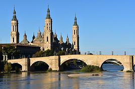
 Aragon méconnuFR
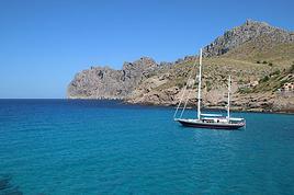 Majorque, rien que pour vos yeuxFR