Bonjour, je pars seule à Tenerife mi février.
y a -t-il des risques à randonner seule ?
Pouvez-vous me donner des indications sur la randonnée de Masca (je suis sujette au vertige.....)
Merci
"les vrais voyageurs sont ceux là seuls qui partent pour partir" (Charles Baudelaire)
Je ne pense pas qu'il y ait de gros problèmes à randonner toute seule sur Tenerife. Surtout sur les sentiers un peu connus comme Masca dont tu parles tu ne seras au finale jamais vraiment seule.
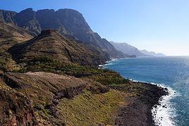
D'ailleurs je suis également sujette au vertige et pas de problème pour Masca, on descend le long d'un barranco c'est à dire un espace entre deux grandes parois mais on n'est jamais sur un corniche ou quelque chose comme ca donc pas de vertige!
Je te conseille aussi la randonnée du Teide en un ou deux jours c'est magnifique !
N'hésite pas si tu as d'autres questions et si tu veux voir quelques photos des randonnées rendez-vous sur mon blog: www.mylittleroad.com
A bientôt
Solène (www.mylittleroad.com)
Retrouvez pleins d'itinéraires et de bons plans sur mon blog: www.mylittleroad.com
J'ai fait Masca avnt hier formidable. Pas de vide mais le chmin est accidente. Si tu redoutes ce genre de chemin, en fait c'est plus facile en montant qu'en descendant.
merci beaucoup, je pense que je le ferai plutôt en descendant pour pouvoir rentrer en bateau, puis en bus (je suis en voiture de location). Est ce que la route qui mène à Masca est vertigineuse ?
Vous qui revenez, le Teide est-il accessible en ce moment ?
"les vrais voyageurs sont ceux là seuls qui partent pour partir" (Charles Baudelaire)
merci beaucoup, je pense que je le ferai plutôt en descendant pour pouvoir rentrer en bateau, puis en bus (je suis en voiture de location). Est ce que la route qui mène à Masca est vertigineuse ?
Vous qui revenez, le Teide est-il accessible en ce moment ?
La route de Masca est étroite (il faut faire attention en se doublant) et raide, mais belle et très bien entretenue. Pas de problème de sécurité (les roues ne sont jamais au bord du vide). Après elle reste un peu vertigineuse quand même...
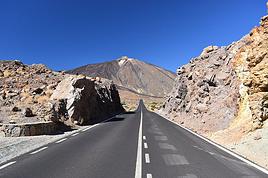
Ils ont refuse que je grimpe du telepherique au sommet, le chemin etait 'ferme a cause de neige et glace', mais a mon avis c'etait de la foutaise, il n'y avait presque pas de neige ni glace et j'aurais pu le faire facilement (j'etais deja monte a pied de la route et entre le refuge et le telepherique il y avait bien plus de neige et de glace, tout gele le matin, donc j'avais fait le pluis dur).
Bonjour, non, le teide n'était pas accessible en voiture. J'ai laissé la voiture et je suis montée et redescendue à pied. (17 km).
Les sentiers de rando fermés aussi, impraticables. Refuge fermé également.
Mais je suis rentrée le 23 février, ça a peut-être changé...
Essaie de te renseigner avec l'ot de tenerife.
Pour info, le barranco de Masca pas facile (4h au lieu de 2h30).
Mais bon, sorti des zones urbanisées, Tenerife vaut le coup. Mais peut-être connais tu déjà!
Bon voyage.
"les vrais voyageurs sont ceux là seuls qui partent pour partir" (Charles Baudelaire)
Bonsoir et merci de ta réponse rapide qui confirme mon impression que le refuge était fermé et l'endroit inac
cessible car j'ai envoyé des mails qui sont restés sans réponse... Si je comprend bien tu es montée à pied par la route ? Nous pensions monter par le chemin de rando depuis le bas... BOn on verra , peut être les conditions auront changé...
Je suppose que nous aurons d'autres possibilités de randos... nous partons un peu à l'aventure comme d'hab !
Encore merci.
Bien cordialement.
Christine
A Tenerife, il y a plein de sentiers qui sont interdits ou fermes avec une inscription 'En mauvais etat' mais c'est totalement abusif. On m'a empeche de monter du telepherique au sommet du volcan alors qu'il n'y avait qu'un peu de neige et glace, et ensuite j'ai passe outre a 2 autres reprises a ces interdictions et constate que les sentiers etaient dans un etat totalement normal. Avec des criteres pareils, on ne pourrait plus marcher nulle part (comme dans les Alpes ou Pyrenees).
Pareil. Rejoindre Masca depuis Santiago del Teide est vraiment chouette mais est également "interdit" car non entretenu (PR-TF 51 ou une variante si je me souviens bien). Aucun problème au final et les vues sur le barranco de Masca sont sublimes.
Bonjour et merci.
J'ai noté en effet que l'accès est actuellement fermé...
J'ai envoyé un message.
Toutefois si ce n'était pas possible puis je envisager le Guajara ? c'est quand même nettement moins haut sauf s'il décide de fermer tout le parc bien sûr
Sinon une autre rando sur l'île ...
ok merci à vous 2 mais le pico Viejo est quand même à plus de 3100 m, ce sera peut être là aussi enneigé mais si effectivement il n'y a pas de contrôle on pourra tenter avec des crampons
effectivement très intéressant.
vous avez aussi wikiloc site où l'on trouve des centaines de randos pédestres ou vtt dans le monde...par contre cela nécessite de connaître le nom de la rando...
merci
je pense faire le Guajara, en partant du Parador, puis en passant la Degollada de Guajara, et au lieu de revenir sur mes pas, passer par la Degollada de Ucaca (plus exposée parait il) et donc revenir en boucle sur le Parador.
j'ai la trace GPS. les randonneurs qui l'ont fait le donnent autour de 4 h 30 à 5 h environ et 11 à 12 km selon les infos
est ce ok ? merci. je vais acheter le guide des randos je crois édition
Je ne sais pas. J'ai fait Guajara en partant de la station du téléphérique, ce qui rallonge un peu, à travers toute la cañada.
Pour info "live", je suis depuis hier à Taganana (Massif de Anaga, Tenerife) pour 4 jours.
Très belles balades dans le secteur.
Temps "plutôt pas beau" et températures dans les 10°.
J'ai fait une boucle en effet, je ne pourrais plus donner les details, le sentier etait marque 'ferme' et 'interdit' mais en realite il n'y avait aucun probleme.q
Bjr arrivée aTENERIFE SUD un dimanche a 18h debut janvier que faire pour hebergement rechercheadresse hebergementpour randonneursur LOS CRISTANOS j'aurais ma…
Notre projet: partir à 3 adultes (2 bons marcheurs, le 3eme fatigable) pour une semaine de vacance découvertes à Teneriffe ou Lanzarotte. Notre idéal: allier…
J'aimerais descendre les gorges de Masca. est ce que le sentier est ouvert et comment remonter au point de départ? je serai motorisé. Ce n'est pas très clair…
Nous partons 10 jours à Tenerife début octobre. Mais nous ne savons pas où loger. Nous aimerions être proche des plages et des randonnées. Idéalement, nous…
Nous partons en couple 15 jours sur La Gomera et Tenerife. Après 1 semaine complète sur la Gomera où nous ferons une rando circulaire sur toute l'île, nous…
Bonjour,
Nous souhaitons faire le trek de 4 jours reliant Mestia à Ushguli sans agence. Il est précisé dans les descriptifs qu'il existe des hébergement à chaque étape, mais on ne trouve pas d'info sur ces hébergements. Quelqu'un a-t-il des infos et un avis sur ce parcours?
We're planning to trek in Peru and Bolivia and would love to find some local agencies.
If you know any, could you share details on prices and, of course, the names of the agencies?
Which trek would you recommend?
Elocine
Je pars en autonomie totale sur un trek au Maroc (10jrs) Imilchil - Aghbalou.
Trouve t-on des cartouches gaz à vis (Coleman, Primus) à Marrakech (adresse) ou villages entre Imilchil - Aghbalou ?
Si non , trouve-t-on des cartouches Butagaz pour camping-gaz (petit volume 230 gr ...)
Merci d' avance pour vos réponses
Hello, I’d like to embark on a little trip in my home country, Switzerland. I’ll start walking from La Cure, heading toward Le Noirmont first, then I’ll improvise my route—but it’ll probably follow the French border... at least as far as Lac de Joux.
I’ll decide day by day how much farther to go after that. My goal is to stay in nature as much as possible, wander around for as long as I can, and restock food in villages or towns along the way.
I’m thinking of mostly camping, but we’ll see if I end up in a hotel or another campsite depending on my route.
I’d love to reach La Chaux-de-Fonds on foot... maybe even Delémont.
The whole thing should take about a week, give or take.
I’ll be bringing my dog, and I’m preparing for this as soon as I’m ready.
Any tips to make sure everything goes smoothly for us? Things I should know—or avoid? What about shepherds with their flocks of sheep? And isn’t hunting season open right now?
I’m not sure if what I’m planning is even doable, which is why I’m asking around.
This’ll be my first time doing something like this—wandering in nature *and* with a dog. I’m really excited for this adventure... and I need it. Thanks!
We’re really keen on ecosystems and want to hike in "natural" ancient forests—not planted woods or areas heavily degraded by human activity. Travel guides (like Lonely Planet) don’t provide much info on this. Could you point us to the most interesting spots?
Thanks in advance for your tips.
We wish you happy holidays and a fantastic 2026, full of discoveries!
Claire and Albert
Hi, this might not be the right section, but I’d like to know if it’s possible to start mountaineering with another person without necessarily hiring a guide. We’ve done quite a bit of hiking but not mountaineering—we’ll just do a half-day glacier course. After that, we were thinking of starting with La Grande Motte and the Pointe de la Traversière, which were recommended to us. Honestly, for things like roping up and knots, I’ll learn at home with lots of videos and a book.
Hi,
I don’t know Switzerland at all and was wondering if Vallée des Joux and especially Dent de Vaulion are packed early in the morning or late in the afternoon in July and September?
If so, do you have any quieter spots to recommend in the area, or in Luxembourg (yes, I know it’s not the same country 😉)?
Thanks a lot!
Jaimerais savoir si quelqu'un aurait fait des treks sur le Ruwenzori et combien ça coute en moyenne, les infrastructures, les paysages la sécurité sur les lieux, merci beaucoup. J'attends avec impatience vos réponses.
We’re leaving in 9 days for a two-week trip to Madeira, mainly to hike.
From my research, I’ve found that since last year, access to most trails—and systematically for the most popular ones—is now paid. You have to pay an access fee of 4.50 € per person per classified hike in 2026, and even 10.50 € for the most iconic hike: Pico Arieiro to Pico Ruivo. When paying, you also have to choose a day and a 30-minute time slot for your start time. Of course, this reservation is neither changeable nor refundable, even if the weather that day is terrible.
Personally, given the massive influx of tourists to the island in recent years, I don’t mind paying a fee to help maintain the trails. Similarly, setting a limit on the number of people who can hike them per day is certainly preferable to preserve this priceless heritage.
However, what’s much less fair is that in reality, most of the available spots are reserved: 1/ for Madeira residents (which is normal); 2/ for "economic operators" (meaning local tour operators). For example, if you’re a non-resident (independent tourist), no booking is possible for the Pico Arieiro hike for an early morning start before September! So, unfortunately, we’ll have to skip this hike.
It’s the same issue for Ponta de São Lourenço, the 25 Fontes, Pico Ruivo... in short, all the most popular hikes. Oh well, we’ll skip those too!
So my question is: which hikes do you recommend where we won’t face the huge crowds that the others get? And where we can book the day before for the next day, taking the weather into account?
Finally, a quick accommodation question: we’ve booked the first week in Funchal, but I haven’t decided yet for the second week. Do you have any advice on where to stay in the south or north, preferably avoiding overly concrete-heavy and touristy spots?
I’m reposting about the logistics for Samaria Gorge.
I’d love to get recent info, especially about whether it’s possible to park my car in Omalos, do the hike, and then catch a bus back to my vehicle.
In theory, it’s doable, but when you check the KTEL website, there aren’t any feasible schedules listed. If anyone has recently organized this with reliable, verified details, I’d really appreciate it. Thanks in advance!
Hi there,
We’re flying from Montreal to Lyon this August to go hiking in the French Alps. We’ve rented a car and will be staying at campgrounds. We’re planning to do day hikes and want to stay a few days in one spot, do a few hikes, then move on to our next camping spot. Could you share your favorite spots or any recommendations for places to spend a few days with great hikes?
A few details:
We arrive in early August and leave in early September.
We’re looking for day hikes (or shorter), moderate difficulty, with a cumulative elevation gain of no more than 1000m, and of course, beautiful scenery!
We’d prefer not to drive too much—maybe it’s best not to head too far south and deal with unnecessary heat?
Along the same lines, if you know of any great campgrounds where we can start our hike directly without needing the car, we’d love to hear your suggestions!
Bonjour
Souhaitant faire de la randonnée sur cette île, je voudrais d'abord savoir quelle serait la période la plus favorable sachant que j'avais passé quelques jours en novembre 2018 pas pour cette activité mais plus pour une simple découverte de l'île et le temps n'était pas top notamment en montagne. Donc peut on choisir une organisation en étoile sachant que je louerai un véhicule avec éventuellement 2 points d'hébergement.
Je n'envisage pas d'intégrer une structure mais de partir à 2 et de s'organiser sauf si vous me conseillez une agence locale ou un guide local. Enfin même si je compte me procurer les différents supports, carte et topo guide plus gps je vous remercie de bien vouloir me communiquer les randos à faire en priorité
Merci beaucoup pour vos informations
I’m planning to do the Mercantour crossing following the Randoxygène route in mid-July.
I’m used to hiking in the mountains, but I sometimes get vertigo, for example on ridges with drops on both sides. I wanted to check if there are any T4 or T3-T4 sections and find out if there are any very exposed passages—and if so, where—so I can plan an alternative route.
Can anyone give me some info on this?
Thanks!
I’m planning a trip around Cap Corse and the AGRIATES in 2026, from May 8th to 15th (there are still 2 spots left, by the way! Just DM me if you're interested).
I’d love to know which hikes are worth prioritizing in the AGRIATES. We’ll be staying in SALECCIA for two days as our base—what should we focus on from there?
A round trip to IGNHU beach? Any other suggestions?
For Ostricano, I think it’s too far for a round trip...
Thanks for your tips!
Have a great day,
Anie, Toulouse
I’d like to get some info about the GR10 Pyrenees traverse. I need help planning the daily stages and accommodations—my wife isn’t an experienced hiker but walks a lot, so I’d like to schedule shorter walking days and thus a longer overall trip in terms of number of days.
Could anyone give me some help and advice?
Best regards,
New to this forum, I’m planning a pretty big project for 2028.
I’m heading to Nepal to do a trek from Kathmandu all the way to Everest Base Camp (a cool 5,300 m 😄).
This trek is a bit special because even though I’ll be part of a group, I’m going solo (so far, no problem—I’m used to it). But it’s my first real trek, and it’s also a humanitarian one: once I reach base camp, I’ll stay an extra week to help clean up the waste left by tens of thousands of climbers! Since I’m originally from South America, from two countries that share the Andes, I have a deep respect for mountains—they fascinate me. So Everest… it’s kind of the trip of a lifetime!
So, a little question for those who’ve done treks to Everest before… any tips for good mental preparation (I’m already working on the physical side)?
Hi there, I’m planning the Annapurna Circuit for March 2027 and I’m looking for a local agency with a local guide—preferably French-speaking—to arrange this trek for us. Any suggestions? Thanks
Hello!
We’re spending a few days in Toraja country at the end of May. We’d love to do a day trek—taking our time—on a route that’s stunning in terms of scenery, but not a level 5 in difficulty!
Any suggestions you can share, please?
Thanks in advance
I’d like to do the Mare a Mare Sud in May over 4 days. I’ve found quite a few places to stay along the route, but I’m stuck on the start and finish.
I’ll be arriving by plane on Sunday evening and would like to start pretty early on Monday morning. Ideally, accommodation right at the trailhead (Alzu di Gallina) would be amazing, but I can’t find anything. Any tips?
Also, for the transfer from Figari Airport to Porto Vecchio or Alzu di Gallina?
At the end, I’d like to pick up a rental car—any advice on that too?
I’m traveling solo by plane to Catania in May and plan to hike the northern side of Etna, starting from Linguaglossa where I’ll arrive by bus. After that, I’d love some info on how to get up to Piano Provenzana (shuttles or hitchhiking), since it seems there’s no public transport except in the summer. Can you sleep there in a free or cheap refuge, or camp? And how far up can you go without having to hire a guide? Thanks in advance. Bernard.
Bonjour a tous,
je pars en voyage au Maroc en aout et nous allons commencer par nous arrêter a Chefchaouen(nous sommes en voiture).
Ma question: quelqu'un peut il m'indiquer un itinéraire de rando en boucle d'entre 5 et 7 jours aux départ de Chefchaouen dans le parc de Talassemtane passant si possible par le pont de dieux?Ou un guide papier qui en reunis quelques uns?
Nous privilégions le camping sauvage et les gites.
Merci d'avance
Hi there, for those who’ve been recently—is it possible to find other solo travelers in March on the island to share transport or room costs? It doesn’t seem easy to travel on a budget.
If you have any recommendations for simple lodgings or places with dorms, I’d love to hear them.
For those who’ve done multi-day treks while moving around: do you need to bring your own sleeping bag? I’d love to hear about itineraries you’ve done without a guide, just with a map and GPS.
Thanks, and have a great day!
Hi everyone!
We’re planning a 15-day road trip to Scotland this summer, specifically to explore and hike on Lewis and Harris—places we’ve never been before. We’ve visited other islands on previous road trips in Scotland (we usually go in April for a week). This would be our first time in Scotland in the summer and for 15 days. We’re looking at late August to early September.
I’m currently drafting the itinerary. We’d be crossing from Ullapool and were thinking of spending 3 nights on Harris and 4 nights on Lewis.
Does that sound balanced to you? Is it better to keep the same accommodation on Harris and the same on Lewis to explore the area? I’d love to hear about any past experiences you’ve had on these islands.
Thanks!
Hi there, I’m trying to leave for 15 days very soon to São Vicente. I’m either looking to join an agency or figure things out on my own to go hiking on one of these islands or both. From what I’ve seen, it’s not easy to organize with local transport, so it gets expensive. Can I use the services of a small local agency? I’m looking for the simplest way to hike for several days. Also, how do you get from São Vicente to São Nicolau? Thanks in advance and have a great day!
Aichatou
I’ve been wanting to do this for several years, and this year’s the one. Next September, I’ll be trekking in Tusheti (Georgia), from Omalo to Shatili.
Of course, I won’t be renting a vehicle that’d just sit unused. No problem getting to Pshaveli, but from there to Omalo, it’s a dirt road (still the case?)
There must be some form of public transport since there are so many guesthouses, and not all travelers come in a 4x4.
If any of you have been to Omalo, could you confirm that these shared transports exist and how often they run?
we’re planning a trip to Yellowstone and hoping to do a three-day backcountry hike if we get a permit.
if any of you have done this before, could you let me know if it’s possible to find water along the way? And if we can transport it, are we allowed to use a stove?
Hello,
I’ll be in Nepal from March 6th to 29th (we’re flying into Kathmandu via Varanasi and leaving via Delhi).
I’m a bit confused about the regulations requiring a guide.
My wife and I (we’re 63 and 64) aren’t experienced trekkers—we’re more used to walking on terrain with very moderate elevation changes. I’m looking for fairly easy hikes, possibly day trips.
Here are my questions:
- Does the Poon Hill trek from Pokhara require a guide, or is it better to go through a local agency? (I’ve seen a lot of them offering 4-day packages)
- I’d like to do a few multi-day hikes around Jomsom (Kagbeni, Mukitinath, Lupra, Marpha)... Do you need a guide for those, and can you find accommodations easily without booking in advance?
Last question—I’m really hesitant to lug around a sleeping bag or down jacket during our 6 weeks in India. Can you easily find these kinds of items at reasonable prices in Pokhara?
Thanks in advance for any tips you can share!
Yann
 La balade du Pico Viejo est très belle aussi.
Les deux se font généralement dans la plus grande solitude...
La balade du Pico Viejo est très belle aussi.
Les deux se font généralement dans la plus grande solitude...