Bonjour.
En juin 2018 je prévois une sortie (une journée) en jet ski , sur le lac Powel.
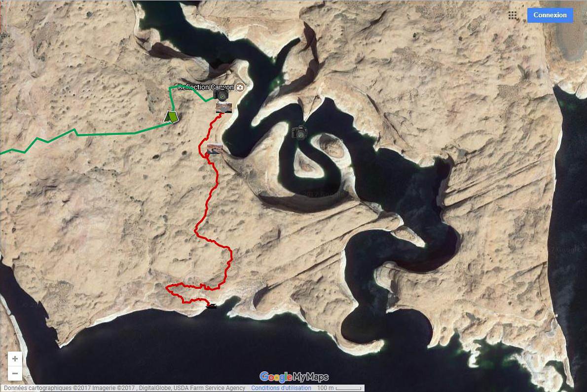
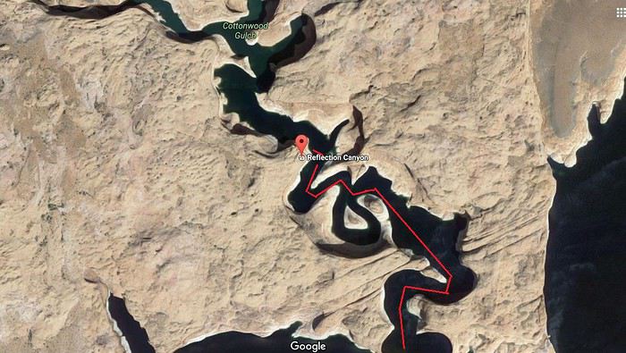
Sur ce site : www.thewave.info/index.html, l'overlook de Réflection Canyon serait accessible par le lac, après une courte rando (en rouge) de 1,6 km (voir photo).
De l'embarcadère jusqu'au départ du trail il y a 65km ?????
Question 1 : 65 km dans les bras est ce possible ?
2 : autonomie du jet (en fonction de la vitesse) vitesse de croisière idéale pour la
fatigue ? Je sais qu'il est possible de se ravitailler (essence) sur le lac .
Je demande l'avis de spécialistes du jet ski.
Merci à tous. Bonne soirée. Simonic.
Bonjour.
En juin 2018 je prévois une sortie (une journée) en jet ski , sur le lac Powel.
Sur ce site : www.thewave.info/index.html, l'overlook de Réflection Canyon serait accessible par le lac, après une courte rando (en rouge) de 1,6 km (voir photo).
De l'embarcadère jusqu'au départ du trail il y a 65km ?????
Question 1 : 65 km dans les bras est ce possible ?
2 : autonomie du jet (en fonction de la vitesse) vitesse de croisière idéale pour la
fatigue ? Je sais qu'il est possible de se ravitailler (essence) sur le lac .
Je demande l'avis de spécialistes du jet ski.
Merci à tous. Bonne soirée. Simonic.
salut
super idée ! 😎
je vais au lake powell tous les 2 ans environ et je loue à chaque fois un 19'
en 2014 je voulais prospecter de Bullfrog pour changer et je suis allé à reflection canyon
mais c'est pratiquement à mi chemin entre wahweap et bullfrog
pour tes questions :
oui c'est parfaitement possible ; en jet il ne te faudra pas longtemps par contre tu n'auras pas assez d'essence pour l'A/R ...
il n'y a pas que les bras qui tirent , les cuisses et le dos aussi .
en général le lac est trés tranquille ; pas comme en mer ou tu dois faire attention au clapot et aux vagues .
tu ne peux faire le plein qu'à dangling rope si tu pars de whweap ou hall crossing si tu part de bullfrog
la vitesse idéale est plus que subjective ; ça dépend de toi et de la météo ...
un jet peux aller à 70 kms/h mais à cette vitesse ça secoue pas mal parfois .
attention de prévoir une carte et/ou un gps car le lac est immense et malgré le balisage on s'y perd facilement
en bateau je t'aurai dit ok de suite mais un jet n'a pas suffisamment d'autonomie
j'ai l'habitude de louer ici :
http://www.lakepowell.com/things-to-do/powerboat-watercraft-rentals/
par sécurité , à ta place je leur enverrai un mail ou tel pour leur demander si l'A/R est possible en fonction du modéle.
quand tu dis " De l'embarcadère jusqu'au départ du trail il y a 65km " tu parles d'une des 2 marinas ? car oui c'est à peut prés ça .
mais il faut entrer dans le canyon directement ; d'abord parce que c'est plus beau et aussi plus pres de reflection canyon
sur ta photo le gars s'est amarré là mais tu peux aller ailleurs .
il faut juste prévoir une corde assez longue pour amarrer ton canot assez loin du bord car il n'y a que des rochers au fond ou si tu y arrives le hisser sur le bord mais attention à la coque ...
le mieux c'est de trouver un house boat qui accepte de te le garder un moment .
dernière chose , le niveau de l'eau baisse d'année en année et de façon spectaculaire ce qui fait que le trait de cote change trés vite
il y a encore 10 ans on allait au rainbow bridge pratiquement en bateau maintenant il faut beaucoup marcher
si tu veux plus d'infos sur le lac n'hésite pas
Bonjour Thierry.
Merci pour ces précieux conseils. Je vais faire un tracé GPX de la Marina ( Wahweap) jusque Réflection, que je vais injecter dans mon gps. Peut être question bête ? : si je veux suivre (à l'aller vers Réflection) la rive gauche du lac , est ce possible. Ou dois je circuler plutôt sur la droite ?
Encore merci. Bonne journée.
Jacques.
si je veux suivre (à l'aller vers Réflection) la rive gauche du lac, est ce possible. Ou dois je circuler plutôt sur la droite ?
On peut considérer le lac, qui n'est que le lit du Colorado (en première approximation), comme un chenal et la circulation se fait généralement à droite mais tu as une bonne visibilité, une bonne maniabilité et surtout une bonne vitesse donc tu peux, grosso modo, naviguer comme tu veux.
Bien évidemment, toujours dans le respect des autres 😉.
Je te souhaite une très bonne balade, aquatique et terrestre.
PS : même si cela semble évident, une sacoche étanche pour ton appareil photo est à prévoir.
Bonjour Thierry.
Merci pour ces précieux conseils. Je vais faire un tracé GPX de la Marina ( Wahweap) jusque Réflection, que je vais injecter dans mon gps. Peut être question bête ? : si je veux suivre (à l'aller vers Réflection) la rive gauche du lac , est ce possible. Ou dois je circuler plutôt sur la droite ?
Encore merci. Bonne journée.
Jacques.
Salut Jacques
en complément de ce que dit Alain Pierre il n'y a pas de rail de circulation sur le lac ; tu peux y faire ce que tu veux dans la limite du respect des autres ( vitesse ... )
le balisage est surtout là pour aider à se reperer
surtout si tu explores des canyons resserré il faut aller trés doucement dans les courbes mais ça tombe sous le sens
de wahweap c'est peut être un poil plus loin mais on a vite fait d'entrer dans les canyon et "perdre " du temps
il te faudra tout de même la carte en complément du gps , elle est vendue dans les marinas .
connaissant un peu les américains j'ai toujours été trés surpris qu'ils ne demandent aucun permis pour louer des bateaux ou VNM ....
cependant je n'y ai jamais croisé de fous furieux comme on peut en voir parfois en mer
et au moindre écart de vitesse à proximité des marinas ou d'autres usagers tu as vite fait de te faire reprendre .
tu es vraiment fixé sur le jet ? moi je ne peux plus en faire 🤪 mais de toutes façons madame et notre ado préfèrent le bateau ; en famille c'est top ; on emmène la glacière ; les effets perso ...
habituellement on fait de la voile mais là c'est pour le fun
tu seras seul ?
regarde ce post récent où j'avais mis quelques photos ; j'ai la flemme de les re-télécharger 😉
voyageforum.com/...ge-arizona-d8224076/
j'avais remonté au max l'Antelope canyon ; pas un chat
le 200CV avec la bouée = éclate totale 😎
pour l'essence , dans les marinas c'est trés cher et beaucoup prennent un jerrycan en ville mais en jet pas trop moyen .
toujours utile de rappeler la dangerosité de l'essence trés volatile et inflammable par rapport au G.O .
il y a beaucoup d’européens dans le personnel des marinas ( étudiants ) .
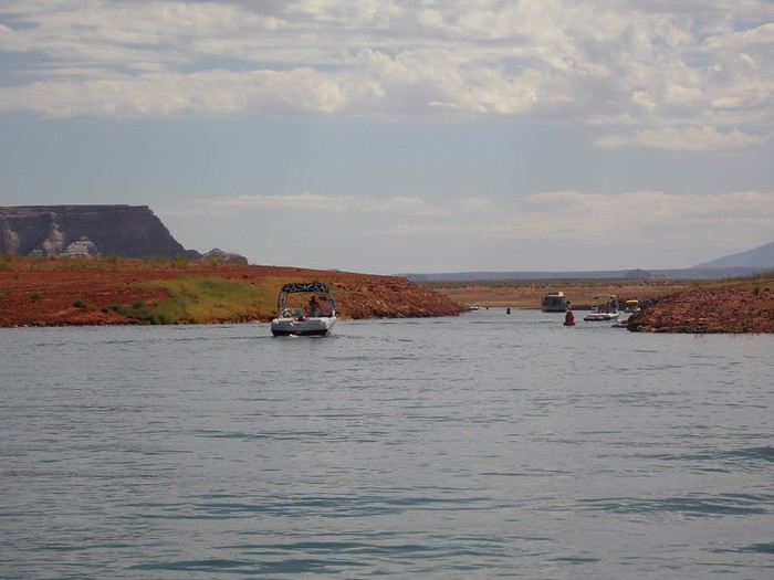
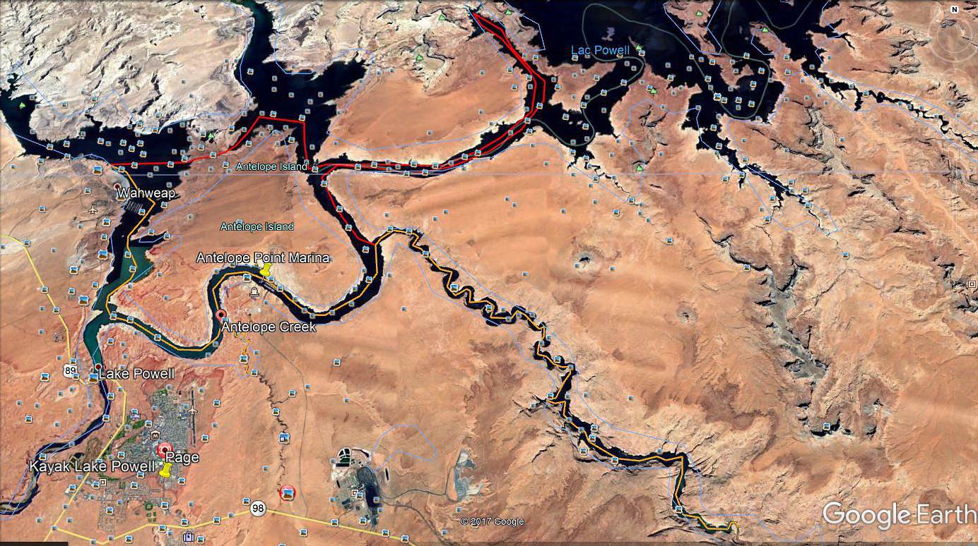
attention , la carte que tu mets sur ton post est trés ancienne ( 10 ans au moins ) et il n'y a plus qu'un minuscule chenal pour passer au nord d'Antelope island ( photo )
tu est focalisé sur reflection canyon ? car il y a rainbow bridge qui est vraiment à voir ; il faut marcher un peu ...
mais sinon tous les coins sont superbes ;
n'oublie pas d’amener de la crème solaire , des chaussures et beaucoup d'eau en plus de la sacoche étanche .
le probleme du jet c'est que tu es limité
mais je te conseille d'aller jusqu'au bout dans reflection canyon ; juste en bas il y a une " plage "
si tu veux plus d'infos ...
je te conseillais de voir avec la marina au niveau du temps aussi car en comptant l'A/R ; les détours inévitables ; la baignade et les ballades il faut ramener le canot vers 17h30 ( si tu le prends pour une journée ; ce qui me semble indispensable )
j'ai hâte d'y retourner 😎
Re coucou.
J'ai refais le tracé gpx d'après Google Earth. En effet çà change la donne.
Tous ces reliels en plus. On va bientôt le parcourir a pied !!!!!
Bon week end. Jacques.
Après mures réflections ( si on peut dire) projet Réflection Canyon abandonné.
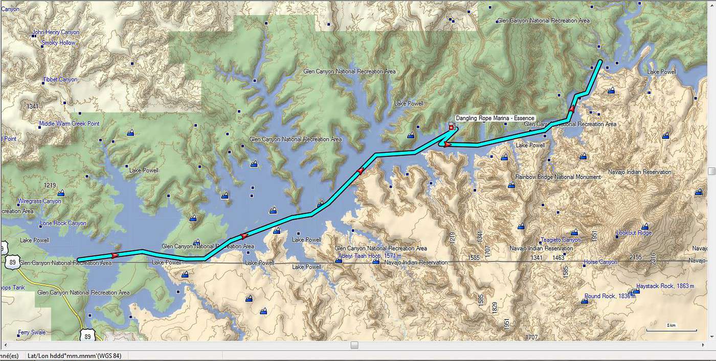
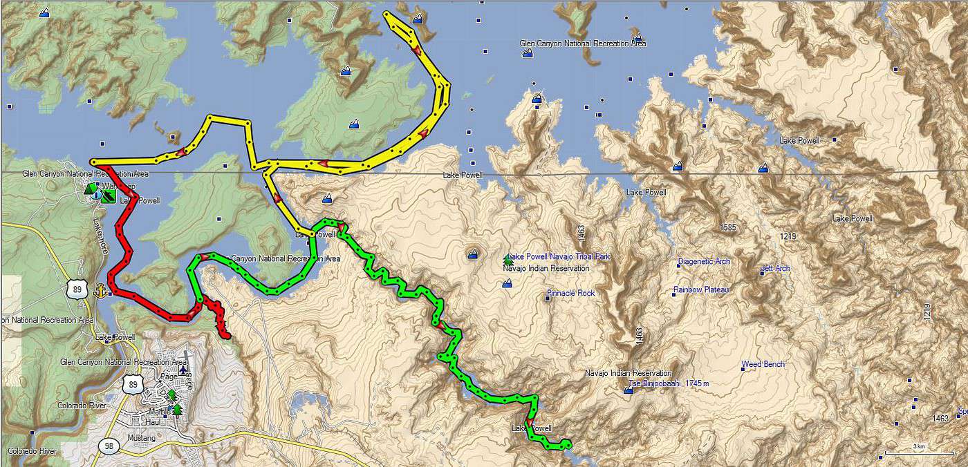
J'ai fait un nouveau tracé sur le lac : 150 km minimun. C'est a dire 5 heures mini A/R sans arrêt.
Je crois que je vais prendre autant de plaisir a déambuler dans les petits canyons : Antélope creek, Navajo Canyon et Gunsight Bay et retour, 110 km (voir tracé) et si manque de temps je peux toujours couper au plus court.
Tracé sur Map Source et Google Earth.
Bonne soirée. Jacques.
Après mures réflections ( si on peut dire) projet Réflection Canyon abandonné.
J'ai fait un nouveau tracé sur le lac : 150 km minimun. C'est a dire 5 heures mini A/R sans arrêt.
Je crois que je vais prendre autant de plaisir a déambuler dans les petits canyons : Antélope creek, Navajo Canyon et Gunsight Bay et retour, 110 km (voir tracé) et si manque de temps je peux toujours couper au plus court.
Tracé sur Map Source et Google Earth.
Bonne soirée. Jacques.
tu as vu la différence !
ça change d'année en année et pas en bien ... 😕
bizarrement ça n'inquiète pas vraiment les américains
je ne voulais pas t'influencer pour reflection canyon mais c'est un des spots les plus éloignés par le lac .
tu verras que tu t'éclateras tout autant en ne t'éloignant pas trop de la marina .
Tu as vu mes photos d'antelope creek ; sublime endroit .
si tu veux faire une pose il y a la récente marina d'antelope point
au fond de gunsight bay il y a un beau point de vue pour faire quelques photos ( alstrom point ) même si tu a des points de vue plus accessibles le long de la route .
navajo canyon est trés long mais tu n'est pas obligé d'aller au fond si tu manques de temps
une précision pratique : attention au branches semi-submergées dans les canyons ; avec le jet tu craints moins qu'avec une hélice mais la coque n'aime pas trop .
ton trajet total est faisable tout en se ménageant des moments de détente et ce qui est bien c'est que tu peux gérer ton parcours en fonction de ton temps restant .
Bonjour,
je me permet de me greffer à la discussion car j'ai 2/3 petites questions...
Nous allons louer un 18' ou 19' pour 2jours (20-21 sept environ) (ainsi qu'un kayak pour aller plus profond dans les canyons) ;
on compte aller faire un tour au labyrinth canyon, mais j'aurai bien aimé pousser jusque reflection...
- vous dîtes qu'il est possible de s'amarrer à plusieurs endroits, puis de monter à pieds au point de vue: est-ce toujours le cas ?
- vous dîtes aussi qu'il vaut mieux prévoir une corde pour amarrer (on l'accroche à quoi?!) , l'ancre ne suffit donc pas ?
- on dormira sur le bord du lac, en tente. Idem, comment amarrer le bateau ?
vous parlez de alstrom point: il est possible de le rejoindre depuis le lac ?! ce serait une bonne nouvelle pour nous, j'ai failli louer un 4*4 rien que pour ça (et hole in the rock road) mais le coût suppl par rapport au suv, sur 3sem, "juste pour ce point de vue"...m'en a dissuadée.
bon, comme vous pouvez voir, je suis bien décidée à le louer ce bateau, mais je manque encore d'infos pratique 😊 ...
Bonjour.
Quand tu parles de la location d'un 4x4 pour la Hole in the rock, ou pour le reste, pourquoi ne pas louer, si vous n'êtes que 2, un Pickup ( pas plus cher que le SUV ). Tu est sure d'avoir un 4x4 haut sur pattes.
Et si tu est camping , tu peux dormir dans la benne.
Bonne journée. Jacques.
Bonjour.
Réflection Canyon par le Lac abandonné. Trop long ( ou pas possible si tu loues le jet une journée ) .
Prévoir la loc 2 jours pour être à l'aise et si tu veux profiter sur place.
Bonne journée. Jacques.
on loue le bateau 2j et on pose la tente qq part, sinon c'est sûr, c'est bcp trop court. On prend également un kayak en plus.
vous vouliez dire "par le lac, abandonnez" plutôt non?
Je ne désespère pas, je continue de chercher des infos, si ce n'est pas possible de jeter l'ancre et d'y aller à pieds par le lac, je veux en être sûre car je ne veux rien regretter.
Bonjour.
Si tu loues 2 jours c'est bon, tu es à l'aise. Voir les heures pour le retour du bateau ????
Et c'est moins fatiguant que le jet.
Bon séjour. Jacques.
Merci, c'est gentil de me répondre si vite :) . Mais je sais déjà tout ça, les 2j etc...ce que je recherche c'est l'accès au point de vue sur reflection canyon, par le lac ;) .
je crois avoir peut-être trouvé, je verrai sur place au pire, tan pis.
ce que je recherche c'est l'accès au point de vue sur reflection canyon, par le lac
Je ne comprends pas ce que tu cherches car la réponse est (en fouillant un peu 😉) sur le lien que tu as donné.
C'est donc ici au cas où tu ne l'aurais pas vu. Tu as le point GPS de départ, les fichiers kml, kmz, gpx, donc tout ce que tu cherches.
Pour répondre à ta question de l'ancre, pas sur que tu puisse "crocher" sur la rive au point 37.18118, -110.9190 mais en regardant sur Goggle Earth, cela semble plus facile au point 37.181504, -110.917996 mais il faudra juger sur place. Nous avions 2 ancres sur le bateau et cela nous a suffit mais on n'est jamais trop prudent si le vent se lève.
En fait, ce n'est pas moi qui ai donné le lien, mais quand je dis 'je crois avoir trouvé", c'est justement de ce lien dont je parlais :) . C'est que je ne m'exprime pas très bien non plus, je crois 😊 . Et puis je ne pensais pas qu'ils fournissaient un gps avec le bateau.
c'est difficile de se rendre compte du "sentier": pas trop difficile ?
Merci à tous en tout cas, j'y serai en septembre, et ne manquerai pas de faire un retour ;) .
J’ai pensé que mon ressenti du trek effectué il y a quelques semaines à Reflection Canyon pourrait intéresser un certain nombre d’entre vous. C’est la première…
L'été prochain, j'envisage de faire la randonnée menant au point de vue sur Reflection Canyon selon le timing suivant: J1: Hole in the Rock Road jusqu'au…
Si les adeptes du hors des sentiers battus sont encore dans le coin, j'aimerais des infos sur le fait de parcourir ces pistes. Je ne connais assez bien les…
C'est une double première pour nous: d'abord une transatlantique (16 nuits), puis mettre le pied en Europe, au départ de Rome (11 nuits)... Total 27 nuits sur…
Nous sommes rentrés dimanche de la transat inaugurale du célébrity réflection de Barcelone à Miami. Nous apprécions les transat car elles sont reposantes (le…
Hi fellow travelers, do you think there’s a real benefit to spending 2-3 days in Yosemite when I’ll already be spending a week in Banff and Jasper in the Canadian Rockies? Won’t it feel a bit redundant? I’m asking because Yosemite is expensive (I’d go with an agency from SF, staying in a cabin, since I’ll be solo and without a car) and apparently packed.
Thanks for your feedback!
Hi there,
We're thinking of driving Route 66 from Chicago to LA in fall 2027 or spring 2028 for about a month.
From what I've found, it doesn't exist everywhere anymore, but that's okay! We're happy to take detours along the way. We're open to visiting less touristy or even completely off-the-beaten-path spots.
Are there any websites dedicated to this road trip?
I'd love any tips and advice for this journey—accommodations, vehicle rental, the pros and cons.
Thanks in advance!
Hello! The itinerary is pretty much set for August 2026. Yeah, I know it’s gonna be *super* hot. But it’s the only time we can get away.
So, here’s the plan: Montpellier-CDG-Dallas.
Stay from July 31 to August 26, 2026:
Car rental – check,
Hotels – check,
Itinerary – almost check,
Photo gear – check,
Budget – check, 🤪
Meal planning – meh, we’ll see...
Walmart, of course, for the cooler when we arrive.
And now, without too much detail...
Fort Worth:
The Longhorns and the Stockyards;
JR’s ranch (for the missus);
Medal of Honor Museum – Arlington.
Houston and NASA Space Center:
See the Gulf of Mexico/America.
San Antonio and the missions.
Fort Stockton for an overnight stop.
El Paso via Guadalupe Mountains:
El Paso and White Sands.
Tucson and the Pima Air & Space Museum:
Tombstone, Bisbee.
Phoenix:
Still working on the program.
Sedona:
Round trip around the area via Flagstaff and Williams, or the Grand Canyon (already done) – we’ll decide on the spot.
Albuquerque:
Santa Fe,
Turquoise Trail,
Los Alamos.
Amarillo via Route 66:
Old Route 66 in the city;
Big Texas Ranch Steak 😏.
Dallas:
JFK Museum;
Perot Museum;
West End district.
And through it all – the road, the road, and more road!!!
We’ll adapt day by day based on our mental and physical state (we’re not exactly spring chickens).
Hello!
We’ll be arriving in Montreal on October 21st for a 3-day stay.
After that, we’re heading to Sherbrooke to visit our daughter, who’s studying at the university there. We’ll spend 3 days with her, and then, since she has a break that week, we’re taking her along for 3 days in Quebec City.
We’ve planned to visit Montmorency Falls and Île d'Orléans.
I’d love to hear what route you’d recommend for the drive from Sherbrooke to Quebec City—we’ll have the whole day to take it easy.
If you have any other recommendations, I’m all ears!
A little disappointed that the fall colors will be over by then, but the dates couldn’t be helped. Thanks in advance for your tips!
Hello everyone,
We’ve planned a trip (retired couple) for late August to the first half of September in Western Canada.
Classic itinerary: arrival in Calgary, Banff, Jasper, Clearwater, Whistler, Vancouver Island, departure from Vancouver.
I know you can’t see into the future any better than I can, so I’m obviously not asking what the wildfire situation will be like in a month...
But if any of you could let me know if, CURRENTLY, there are major difficulties—not just for locals, of course, but for tourists as well?
We’re hesitating between taking the chance or canceling what we still can.
We’re not young anymore and don’t have the flexibility we once did...
A thousand thanks to those of you on the ground or with contacts there who can help us make this decision!
A friend is renting a car for an upcoming trip during the All Saints' holiday.
Nowadays, all rental cars come with GPS, but do you know if you can use it without paying for the GPS rental? I have no idea since I always use my own!
After our first trip as a young couple to the West in 2007 (yes, that doesn’t make us any younger!), we’re planning to go back in 2028, but this time as a family of four! (We have two boys who’ll be 5½ and 13 years old in the summer of 2028.)
Our plan is to combine a few big cities (SF and LA, maybe San Diego) with national parks and state parks, mostly!
Ideally, we’d like to leave at the end of June and head back to France around July 19–20, so we can enjoy the first week of the Olympic Games in Los Angeles.
Since we already did the "loop" in 2007, there are must-see places we absolutely want to revisit—and especially share with our kids: Bryce Canyon, Yosemite, and above all, the Grand Canyon, which is still the most incredible thing I’ve ever seen on Earth!
On the other hand, some places didn’t leave a big impression on us for various reasons, so we’re not making them a priority: Antelope Canyon, Monument Valley, for example.
We’re planning ahead, but might as well be smart about it😏
Do you have any tips for a fun and doable itinerary over about 20–25 days with kids, without rushing?
hi everyone
I’m planning a world trip and I’m looking for great tips on accommodation in the United States.
Do you have any good deals to share, please?
thanks
Hello everyone! Really damaged due to flooding caused by runoff after forest fires (a total mess!), does anyone in this friendly forum have any updates on the Apache Trail between Apache Junction and Roosevelt Dam? Is there still a section of the road that’s tough to navigate?
We're leaving at the end of June and will be driving the route between Buffalo and Cody. We’ve already booked our accommodations and a rodeo in Cody, but during the day, we’ll be driving between the two and I’m unsure about the itinerary.
Which route do you think is the most pleasant, interesting, or scenic between:
- The northern route via Highway 14 with Sheridan, Lowell, etc.
- The southern route with Highways 16/20/14, passing by Loaf Mountain Overlook, Powder River Pass, Ten Sleep Canyon...
We’ll be in a car, so we should be able to drive on any road.
Thanks for your input!
I’m almost done planning our September road trip. After our 3-night visit to Sequoia, we’ll have a stopover night in Coalinga (to break up the drive). We’ll be staying two nights in Monterey and would like to stop along the way to visit one side of Pinnacles National Park. We’re torn between the West entrance and the East entrance, and we’d like to do a short hike of no more than 2 hours since we don’t want to arrive too late in Monterey.
This park is split into two distinct zones with no connection between them, and the mileage from Coalinga to Monterey is pretty much the same for both. Which area do you recommend visiting—east or west? And which route is the most scenic?
I’ve spotted two short hikes:
- East: Moses Spring to Rim Trail Loop
- West: Balconies Cliffs Cave Loop
Has anyone been there, or do you have another hike to suggest?
Thanks in advance, and have a great afternoon!
Marcalamar 🙂
Hi everyone! 🙂
Just a quick question about King Canyon and Sequoia National Park.
Before our night in Miramonte, we plan to visit King Canyon. The next stop will be two nights in Three Rivers to explore Sequoia National Park. I wanted to go all the way to Roaring River Falls on the King Canyon Scenic Byway and then turn back to head to Miramonte. Since we’re coming from Oakhurst, Google Maps says it’s 300 km and 5 hours of driving. Since we also want to hike to see the sequoias (Big Stump Area and Grand Grove) before tackling the King Canyon Scenic Byway, the timing’s going to be tight. How far do you recommend going before turning back to miss as few points of interest as possible on the King Canyon Scenic Byway? Thanks for your advice, and have a great evening!
Marcalamar 🙂
Hi everyone!
After years of hoping, waiting, planning, then changing, saving, and searching for the best possible route... we're FINALLY off this summer for a 5-week road trip in the West.
I had planned a trip to Colorado in 2021 but canceled due to COVID, so with time passing and my eldest’s high school graduation approaching fast, I figured it was now or never!
Anyway, the itinerary has been modified and extended to please everyone (I’m no longer the only one making decisions!!)
Here’s our final route:
Day 1 - 7/12/2026 - Brussels / Los Angeles
Day 2 - 7/13/2026 - Los Angeles
Day 3 - 7/14/2026 - Los Angeles
Day 4 - 7/15/2026 - Los Angeles
Day 5 - 7/16/2026 - Los Angeles
Day 6 - 7/17/2026 - Los Angeles / Kingman
Day 7 - 7/18/2026 - Kingman / Grand Canyon
Day 8 - 7/19/2026 - Grand Canyon / Page
Day 9 - 7/20/2026 - Page
Day 10 - 7/21/2026 - Page / Monument Valley
Day 11 - 7/22/2026 - Monument Valley / Durango
Day 12 - 7/23/2026 - Durango
Day 13 - 7/24/2026 - Durango
Day 14 - 7/25/2026 - Durango
Day 15 - 7/26/2026 - Durango / Glenwood Springs
Day 16 - 7/27/2026 - Glenwood Springs
Day 17 - 7/28/2026 - Glenwood Springs / Moab
Day 18 - 7/29/2026 - Moab
Day 19 - 7/30/2026 - Moab
Day 20 - 7/31/2026 - Moab
Day 21 - 8/1/2026 - Moab
Day 22 - 8/2/2026 - Moab / Vernal
Day 23 - 8/3/2026 - Vernal / Grand Teton
Day 24 - 8/4/2026 - Grand Teton
Day 25 - 8/5/2026 - Grand Teton / Cody
Day 26 - 8/6/2026 - Cody / Yellowstone
Day 27 - 8/7/2026 - Yellowstone
Day 28 - 8/8/2026 - Yellowstone
Day 29 - 8/9/2026 - Yellowstone
Day 30 - 8/10/2026 - Yellowstone / Salt Lake City
Day 31 - 8/11/2026 - Salt Lake City / Bryce Canyon
Day 32 - 8/12/2026 - Bryce Canyon / Zion
Day 33 - 8/13/2026 - Zion
Day 34 - 8/14/2026 - Zion
Day 35 - 8/15/2026 - Zion / Las Vegas
Day 36 - 8/16/2026 - Las Vegas
Day 37 - 8/17/2026 - Las Vegas / Los Angeles
Day 38 - 8/18/2026 - Los Angeles
Day 39 - 8/19/2026 - Los Angeles / Brussels
Day 40 - 8/20/2026 - Brussels / Home
We’ll be alternating between house swaps, motels, and campgrounds. I’ve booked all the accommodations (except the campground at Bryce since sunset bookings open only 14 days in advance) and the first activities, as well as the most touristy ones.
I’m currently putting together my day-by-day roadbook and having some trouble planning certain days, like in LA or Las Vegas. Choosing hikes isn’t easy either—it’s tough to decide!
We’re really excited but could definitely use your help with choices and optimizations!!
Hello.
I’d like to travel along I-15N from San Diego to Las Vegas with my mom, who’s 67. We’ve explored Northern California and the California Coast over the past two years and now want to continue through the desert.
There are several attractions along the way:
- Mormon Rocks
- Desert Discovery Center and visit the Old Woman meteorite
- Joshua Tree National Park
- Mojave Desert
- Mojave National Preserve
- Anza-Borrego Desert State Park
- Silverwood Lake
My mom has back issues that prevent her from hiking or walking on trails with elevation changes. Is it possible to visit these places by car, or are the routes flat enough?
I’d love for her to experience the desert with an itinerary adapted to her condition. I’m also open to other points of interest that aren’t mentioned. We have 3-4 days for the trip, so we’re not in a rush—just want to explore.
I’d love to take a road trip and visit Nova Scotia. I’d appreciate some info on the best cities to see and the most interesting spots. The trip should last about 10 to 15 days, staying in hotels or motels. Thanks in advance!
We’re being relocated to Saint Pierre and Miquelon.
We’ll be taking the flight from Nantes to Montreal and then from Montreal to Saint Pierre.
Could you recommend a hotel near the departure terminal that allows dogs?
Hi,
My 16-year-old son is flying to Grand Rapids with other kids his age. There’s a layover in Detroit. There’s no unaccompanied minor service available. Is it pretty easy to navigate Detroit Airport to catch the connecting flight to Grand Rapids (domestic flight)? There are several of them who speak English well.
Thanks for your replies,
Good evening, everyone! 🙂
Just a few last questions to wrap up our Lake Tahoe visit plans.
**Parking:**
We’d like to walk to Eagle Falls and then Eagle Lake. I’ve spotted two parking lots that seem close to each other and give access to the trailhead. Where and how do we pay for entry to Emerald Bay State Park and Inspiration Point?
**Viewpoints on the East Side:**
Are most of the viewpoints (Balancing Rock, Granite Cave, Bonsai Rock, etc.) right by the road, or do you have to hike to reach them?
**Donner Memorial State Park:**
Is it worth making a detour to Truckee to visit this park and the Truckee historic downtown?
Hi there. I'm shocked by the price of the Upper Antelope Canyon tour—$175 for less than an hour… You might say, "if you can’t afford it…" But the real question is whether it’s really worth it, because $350 for two makes me feel like I’m getting ripped off. For those who’ve done both Lower and Upper, can you tell me if the price difference is really justified? Thanks
Hi everyone! 🙂
As you can see, we're heading back from September 6th to the 27th.
Everything’s booked for September—flights, accommodations, and the car. As I plan, I’ll be asking the experts for help. This is our second trip to California, but most of the stops are new to us.
We’ll start directly from San Francisco to our first overnight stop, Davis, before heading to Lassen Volcanic Park for 4 nights. Our flight lands at 12:50 PM.
Here’s our itinerary:
Day 1: Davis – overnight stop
Day 2: Red Bluff – exploring Lassen Volcanic Park (scenic drive to Lake Helen)
Day 3: Susanville – scenic drive through the park via the South Entrance, points of interest, and hikes
Day 4: Susanville – Cinder Cone and Painted Dunes hike
Day 5: Susanville – Warner Valley (hikes)
Day 6: South Lake Tahoe
Day 7: South Lake Tahoe
Day 8: Mammoth Lake
Day 9: Mammoth Lake
Day 10: El Portal via Tioga Road
Day 11: El Portal
Day 12: El Portal
Day 13: Oakhurst
Day 14: Miramonte
Day 15: Three Rivers
Day 16: Three Rivers
Day 17: Coalinga
Day 18: Monterey
Day 19: Monterey
Day 20: San Francisco
Day 21: San Francisco
Day 22: Departure
For hikes in Lassen Volcanic Park, I’ve planned:
Bumpass Hell, Cold Boiling Lake (Day 2)
Paradise Meadow (maybe not going all the way), Devastated Area, and the loop around Reflection and Manzanita Lakes (Day 3)
Cinder Cone and Painted Dunes (Day 4)
Devil’s Kitchen and Boiling Spring Lake (Day 5)
I’ve read there are trails to access the trailheads for Cinder Cone (11 km) and Warner Valley. Are these easy trails for an SUV?
Are there any other must-see spots or things we shouldn’t miss?
That’s where I’m at for now. Thanks for your replies, and have a great evening!
Marcalamar 🙂
I’m a total USA addict. I’ve already done several road trips, including the East Coast and West Coast.
I’m here today because I’m planning to go back for another road trip on the West Coast. Possibly with one of my sisters and a couple of friends. It’s still just a plan for now, but I’m working on an itinerary in the meantime. Ideally, I’d leave in 2026, but I don’t have the exact dates yet—maybe April-May or September-October.
My last trip to the West Coast was in September 2014. We went for 2 weeks, but this time it’d be 3 weeks. What made me want to go back was simply a colleague who just left today. As I’m writing this, he’s on the plane. I’m so happy for him, but now all I can think about is going back.
Since I recently went to NY, I noticed that prices have really gone up. I assume the same is true for the West Coast? For 2 people over 3 weeks, what budget should I expect? We’re the type to watch our spending and find great tips.
I think we’ll arrive in San Francisco like the first time and leave from either Los Angeles or Las Vegas.
Thanks for advising me on the booking—should I reserve a room in the hotel or go for a cabin for the best view?
Should I get breakfast or not?
What do you think of the restaurant?
Hello, if the off-the-beaten-path enthusiasts are still around 😉, I’d love some info on tackling these trails. I’m not super familiar with the rules, risks, or what to expect—I’m looking for firsthand experience from folks who’ve done it on their own once or multiple times.
Hi everyone!
I’m planning a week-long family trip to NYC in October 2026. The focus is on museums and soaking up the New York vibe. I’ve been checking Airbnb, but the prices in Manhattan are through the roof. Since I don’t know NYC well, is it "wise" to look outside Manhattan? Any neighborhoods you’d recommend?
After our first trip to the West, we’d love to go back to see other must-see spots!
The stay would be from May 11 to 20, 2026—it’s short, but hey...
M11: Lyon to Las Vegas (overnight in Vegas)
T12: Route 66 – overnight in Grand Canyon (GC)
W13: Visit GC – overnight in Page
Th14: Visit Antelope Canyon / Horseshoe Bend – overnight in Monument Valley (MV)
F15: Visit MV – overnight in Moab
Sa16: Visit Arches / Dead Horse Point – overnight in Bryce
Su17: Visit Bryce – overnight in Zion
M18: Visit Zion / Valley of Fire – overnight in Vegas
Tu19: Return flight
What do you think? Could we add one more night somewhere? We’re not big hikers, so we’ll mostly explore the parks using shuttles.
Also, we’re all set—passports are good. Do you think one classic Visa card and one premium Visa card will be enough for coverage?
Thanks so much for your feedback, and happy holidays!
Hi North America forum crew,
Just a little post that might interest some of you:
Travelers to the United States | Photo Now Mandatory Upon Entry and Exit | La Presse