Infos récentes sur le parc d'el cocuy :
Ces dernieres ne sont pas mis à jour soit dans les guides ou les forum ce qui nous un pris un peu au depourvu arrivé a el cocuy.
Car depuis environ 1 an (selon l'office du parc) environ les 2/3 du parc sont fermés dû a des problèmes avec les indigènes qui y vivent (problème de saleté des sentiers, pollution des eaux et pbs avec le gouvernement certainement lié a l'exploitation des gisements et donc à l'argent généré mais nous ne sommes pas rentré dans les details). Il n'est donc pas possible de réaliser le tour de cocuy a guican, seul un petit tour jusqu'au lagnua grande est accessible , pas de possiilité de passer derriere la cordillere.Sachant que le tarif reste inchangé et assez conséquent tout de meme pour le peu de sentiers proposés(50 000 COP, pour les plus de 26ans et 12000COP pour etudiants).Etant un peu decu et surtout de devoir payer si cher pour un acces si limité après moultes négociations nous avons quand meme reussi a obtenir le tarif etudiant(non sans mal ).
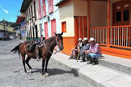
Ce qui est possible de faire au depart de Cocuy en camionette sont les lagunillas (pintada, cuadrada, atravesada et la parada soit 2h a 3h de marche depuis le pueblo ou le laitier vous laisse a 13km de Cocuy).
Les marches de "el pulpito del diablo" et laguna grande sont peu plus longues.Au depart de Guican ce qui est possible de faire : lagunas los verdes et ritacuba blanco. (Apparemment pas difficile mais nécessite la journée)
Sachez qu'a ca il faut rajouter le trajet pour aller jusqu'au sentier soit on peut prendre le camion qui fait la livraison de lait et qui part uniquement a 6h15 tout les matins de cocuy (10 000 COP par pers pour aller au depart des : pulpito diablo, grande, pintata etc.. mais c est 15 000 pour aller au depart des autres et rajouter chaque fois 5000) soit un expresso (80 000 COP pour le véhicule). Et pour repartir si on veut reprendre le camion de lait c'est tot le matin a 7h30 au cabanas de guacan. Et 8h30 a hacienda la esperanza.
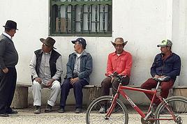
Il y a quelques glaciers egalement accessible du cote de la cordillère. Une chose à noter également c'est l'incroyable gentillesse des gens dans cette région, un vrai plaisir, le problème indigène est donc tres dommageable attendu que les habitants ont parfaitement conscience de vivre en partie grace au tourisme. Meilleur periode décembre Janvier mais en juillet le changement de temps amène de très beaux panorama.
Vous trouverez sur place une boutique qui loue du matos de camping une qui vend des cans de gaz et des agences avec des guides.
Et surtout mefiez vous toujours (au moins un petit peu) de ce vous lisez sur les forums.
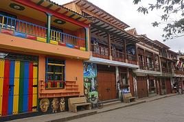
Si on peut aussi conseiller un hote pas cher rustique mais familial , hotel guiterrez 1 cuadra de la plaza.les proprio sont charmants .
J espere que ttes ces infos seront utiles n hessitee pas a nous ecrire pour des infos complémentaires
Dommage de venir de si loin pour tomber sur un PN aux 3/4 fermé.
Il eût été préférable de faire une petite recherche préalable sur ce site ou simplement sur google. En page 1, 6e lien, tu serais tombé sur ça:
http://www.parquesnacionales.gov.co/...ional-nat...
qui t'indique clairement quels sont les sentiers possibles, c'est à dire pas grand chose.
Salut,
En toute logique votre commentaire aurait trouvé une place importante dans les discussions relatant du trek et qui au final n'avaient aucunes réponses de ce type.
Il eut donc était fort sage de poster cette info avant et ainsi, faire profiter aux autres de vos lumières plutôt au lieu d'attendre notre post pour pouvoir dire qu'on est pas malin.
J'espère malgres tout que notre retour sur le trek pourra aider dautres personnes.
Nous restons dispo à toutes les questions.
Tu avais cette discussion que tu trouvais simplement en tapant sur VF: "Cocuy" et en lisant les sujets les plus récents: Tu as ces topics, celui de janvier 2014 et du 13 mars 2014 en début de première page (2e et 6e topics):
Ensuite, ce n'est pas moi qui classe et mets des warnings aux topics.
Pour ce faire, il faudrait le suggérer à l'administrateur du site.
Mais ne te préoccupe pas, tu n'es pas le premier à ne pas te précautionner suffisamment.
Ça m'est aussi arrivé, sans doute plus d'une fois.
Simplement, quand on vient d'aussi loin pour un PN aussi difficile d'accès (11 heures de bus plus transport du village aux entrées du parc), il est navrant de se casser le nez faute de renseignement.
Merci pour ces infos. J'aurais aimé quelques précisions si possible.
Finalement est ce que tu as opté pour des marches à la journée depuis El Coucy ou pour une rando itinérante écourtée?
On m'a parlé d'une rando sur 4 jours; est ce que cela correspond à un aller retour de El Coucy à la lagune Grande?
Est ce envisageable de rayonner à partir d'une des cabanas pour faire les différentes marches toujours autorisées (en particulier "el pulpito del diablo" et laguna grande) où trop long?
Enfin as tu quand même apprécié ton passage dans le parc malgré les restrictions? Y as tu trouvé ton compte en panoramas?
perso, j en reviens, c'est un endroit unique, n'écoutez pas ce que l on vs dit, il faut absolument y aller, il y a des treks de 1 a 5 jours...les paysages st hallucinants...certes la fameuse boucle est fermée mais il y a d'autres options.... voir juan carlos; qui a une agence au village del cocuy, GUAICANY 3105667554, et surtout un chalet du même nom, rustique et authentique...bon départ pr des randos...allezzzzzzz yyyyyy
10h de route ce n est pas la mort...j ai passé une semaine incroyable, il y a des randos a la journée, j'en ai fait perso 3, de 6-8h, avec la fameuse laguna grande, 1000M de dénivelés, départ du chalet familial"esperanza", ambiance feux de cheminée, un acceuil unique des 3fréres, mais j ai rencontré des groupes qui partaient pour plusieurs jours avec un guide, tout est possible... il y a una casa des guides peut etre que tu pourra avoir plus d'info ou appeler juan carlos, numero ci dessus..
Je suis allé trois fois au Cocuy assez récemment. Depuis Bogota, il n'y a pas 10 heures de bus mais 11 au minimum, si tu pars très tôt ou très tard de Bogota, car de 7h à 20h, il y a bcp de trafic et ça va de mal en pis.
Je m'en suis encore rendu compte en novembre dernier. Perso, à chaque fois, c'est 11h30-12h.
A moins que ça ait changé dernièrement, c'est très long car après la bourgade de Capitanejo, la route est le plus souvent dans un état désastreux, de sorte que les bus roulent par moment à 30 kms/h.
Il faut aussi compter ensuite 1h de 4*4 ou 1h30-1h45 de Lechero, solution la plus économique, pour se rendre à l'entrée des Lagunillas. Pour l' entrée menant à la Laguna Grande de la Sierra, je ne me rappelle plus mais c'est quelque chose d'approchant. Quant aux cabanes Kanwara, sous le Ritacuba blanco, c'est loin également: 30 bornes de piste, dans mon souvenir.
Malgré les interdictions, il y a encore moyen de faire de belles choses, mais c'est nettement moins aisé, et encore une fois, on loupe le saint des saints, à savoir le sublime enchaînement de vallées allant de Laguna de la Plaza à Laguna grande de los Verdes, en passant par la plus belle, la vallée de los cojines.
Bien que ce soit illégal, il y a quand même des moyens discrets d'accéder à la Laguna de Plaza et quelques autres endroits très chouettes non autorisés, par des chemins secondaires très peu utilisés, mais c'est un peu en mode exploration: il faut avoir un bon niveau de trek, donc d'orientation et d'autonomie.
qu'est ce que tu es négatif mon pauvre olivier, .. arrête de voyager si tout est compliqué.ET surtout arrête de décourager les gens... en aucun cas tu loupes la laguna grande, encore moins la vallée de los cojines... je les ai fait il y a 10jours...prendre le lechero reste une belle expérience, puisque ce st les petites fermes familiales qui déposent leur lait... Si vs voulez une expérience authentique courez au parc delcocuy.
Tu n'as qu'une unique et petite expérience du Cocuy, tu n'es même pas fichu de retenir les noms des lieux où tu randonnes (à part Laguna Grande), de donner par toi-même des itinéraires, bref de conseiller efficacement et précisément les gens, et tu la ramènes? et tu m'interpelles en me prenant de haut?
qu'est ce que tu es négatif mon pauvre olivier, .. arrête de voyager si tout est compliqué.ET surtout arrête de décourager les gens... en aucun cas tu loupes la laguna grande, encore moins la vallée de los cojines
Tu nous expliques comment tu vas à Los Cojines en rando (via laguna Grande de la Sierra?!)
en 3 jours A/R, puisque tu dis que as fait un tour de trois jours?
Tu nous expliques comment tu y vas et par quel chemin tu rentres?
Tu m'expliques comment tu fais tout ça, malgré l'interdiction qui est toujours là, visiblement?
Tu dis toi-même que la boucle est fermée, or Cojines fait partie de la boucle et est au milieu du parcours.
http://www.parquesnacionales.gov.co/...ional-nat...
C'est très flou ton histoire, donc plutôt que de te la jouer péremptoire et sarcastique, précise ton affaire.
Vis et va par monts et par vaux durant 9 ans dans les Andes, fais-y des treks d'une semaine en totale autonomie, sans guide et sans mule, et on reparlera de nos façons respectives de pratiquer la montagne et de voyager.
Pour qqn qui a le temps, oui, El Cocuy, ça reste intéressant, surtout quand est bon trekker et débrouillard, mais quand on a trois semaines, c'est plus discutable, avec les vallées centrales interglaciaires interdites.
Bonjour
Comme il n' y a aucune carte sur : parquesn........ on a du mal a vous comprendre ( vous qui connaissez les lieux ) , vous n' auriez pas ça dans vos tablettes a fin que l' on puisse s' y retrouver . Merci
C'est une carte assez précise qui montre qu'il y a trois accès aux vallées interglaciaires.
L'entrée par la laguna pintada, l'entrée/sortie par le Col de Cardenillo, l'entrée difficile via Laguna grande de la Sierra et le col très élevé et difficile (T4 voire T5 - 4800 m) de Bellavista, à droite du glacier de Toti, col qui te fait accéder sur la rive occidentale de la laguna de Plaza, dans un endroit d'une beauté extraordinaire.
En gros, de la laguna Pintada au col Cardenillo, il y a 8 cols, tu passes par 8 vallées intérieures avec spécialement trois grandes lagunes: Plaza, la plus belle pour moi car elle est très grande, encastrée dans le roc ou les pentes de frailejones et au pied de beaux pics surmontés de glaciers; Laguna de la Isla, l'une des 20 lagunes en contre-bas N du col de la Sierra, et la laguna Grande de los Verdes, dans une ambiance nordique ou Irlandaise.
La vallée la plus extraordaire est sans doute celle des Cojines, car cette tourbière à coussins à plus de 4000 m d'altitude fait bien ses 4 kms de long, au milieu de deux autres vallons en contre-cas des cols de Castillo et Sierra: C'est un alignement faisant bien ses 12 kms de long, de col à col. De plus, cet ensemble très vaste est entouré des plus belles montagnes et glaciers: San Pablin, Castillo, Romeral, Picos sin nombre et les Ritac Uwa, très impressionnants.
Soit dit en passant il est possible d'accéder aux Picos sin Nombre mais c'est déjà de l'alpinisme mixte.
D'autre part de l'autre côté, les faces impressionnantes des Ritac Uwa offrent de l'escalade très exigeante.
Par ailleurs, le vallon du Pulpito del diablo et du Pico de Azucar (niveau PD-) est impressionnant mais c'est un cul de sac sauf à en sortir par des sentiers assez difficiles. Donc en général on fait un AR.
Cela dit, apparemment, ce secteur est également interdit.
En revanche, Le large cirque glaciaire où se trouve la Laguna Grande de la Sierra est autorisé et il est très beau: Plusieurs lagunes au fond et surtout le glacier Concavo au nord, le glacier Toti à l'est, le Pico de Azucar au SE et le Pulpito plus au sud. Par contre, il est apparemment interdit d'aller au delà du col de Bellavista pour accéder à Plaza.
Merci beaucoup , ainsi nous pouvons bien visualiser tout ce que tu nous expliques 😏
c' est vraiment le genre d' information qui "vaut de l 'or " , on en trouve certaines fois sur ce forum ( c' est d'ailleurs pour cela que nous y allons ) au milieu d' autres messages sans intéret 😠.
je n ai rien a t'expliquer, encore moins a me justifier, je voyage sac au dos depuis plus de 20ans et je n ai aucune lecon a recevoir de toi. Je reviens juste de ce parc, ainsi que de la guajira d'ailleurs.... je dis juste que ce st des endroits uniques pour ceux qui veulent marcher loin de tout....et que durant cette semaine, j ai réalisé quelques belles randos(dont la vallée de los frailejones° , et que en discutant le soir ds les cabanas, j y ai croisé des tas de randonneurs ayant fait des trecks sur plusieurs jours en groupe ou avec guide, ce st des faits.....des randos il y en a pleins et de tous les niveaux....je te reproche juste de mettre trop en avant les cotés négatifs qui font parti intégrantes d'un voyage, on n a rien sans rien... allez al parque del cocuy, a la guajira vs ne serez pas déçu.....
Ne renverse pas les rôles. C'est toi qui me prends de haut, à la base.
Qu'est-ce que tu es négatif, mon pauvre Olivier
Moi, par la suite, je réagis et je te remets à ta place, ce qui est normal, d'autant que je connais manifestement bien mieux le sujet que toi. Je le connais d'autant mieux que je randonne toujours sans guide, passant par tous les chemins possibles et imaginables, ce qui nécessite d'être très attentif à l'orientation et au cheminement, d'y réfléchir avant et pendant. Question de survie.
Soit dit en passant tu ne nous as toujours pas expliqué ton parcours de 3 jours allant à la Valle de los Cojines.
Je suis curieux de voir ça!
Tu es surement un grd passionné de la montagne, mais franchement nul pr la transmettre cette passion, c'était le but de mon intervention en disant tout simplement que je n'étais pas d'accord avec ton pessimisme et que ce parc valait le détour.. et non de donner des itinéraires, il y a la maison des guides al cocuy pr cela....
bonjour,
et dans ces secteurs encore autorisés, les sommets le sont-ils aussi : tels les Ritacuba, Concavito, Pulpito, Pan de Azurcar etc ? Sinon où obtenir ces infos ?
merci d'avance, hubert
Salut, a priori, le secteur Pulpito /Pan de azucar est fermé aussi.
Ritacuba et les sommets du secteur laguna grande de la Sierra: Concavo-Concavito plus Toti (tous trois éventuellement faisables dans la journée) .
Peut-être que tu peux aussi aller aux Pico San Pablin et au Pico Guican. A vérifier sur place.
Nous sommes actuellement en colombie. Nous aimerions aller faire un trek ds le parc del cocuy. Nous aurions aimé savoir si quelqu'un y était allé récemment,?…
Je compte partir en Colombie en novembre /décembre et y réaliser un trek en haute/moyenne montagne sur une dizaine de jours genre el Cocuy, malheureusement…
Nous partons au mois d'Aout en Colombie.Nous souhaitions randonner dans le parc national El Cocuy, mais il est, semble-t-il, actuellement fermé. Quelqu'un…
Je pars en Colombie en décembre pour 3 semaines et j'aimerais beaucoup faire un trek... Le problème, c'est que ca n'a pas l'air folichon la Colombie pour…
Bonjour,
Nous souhaitons faire le trek de 4 jours reliant Mestia à Ushguli sans agence. Il est précisé dans les descriptifs qu'il existe des hébergement à chaque étape, mais on ne trouve pas d'info sur ces hébergements. Quelqu'un a-t-il des infos et un avis sur ce parcours?
We're planning to trek in Peru and Bolivia and would love to find some local agencies.
If you know any, could you share details on prices and, of course, the names of the agencies?
Which trek would you recommend?
Elocine
Je pars en autonomie totale sur un trek au Maroc (10jrs) Imilchil - Aghbalou.
Trouve t-on des cartouches gaz à vis (Coleman, Primus) à Marrakech (adresse) ou villages entre Imilchil - Aghbalou ?
Si non , trouve-t-on des cartouches Butagaz pour camping-gaz (petit volume 230 gr ...)
Merci d' avance pour vos réponses
Hello, I’d like to embark on a little trip in my home country, Switzerland. I’ll start walking from La Cure, heading toward Le Noirmont first, then I’ll improvise my route—but it’ll probably follow the French border... at least as far as Lac de Joux.
I’ll decide day by day how much farther to go after that. My goal is to stay in nature as much as possible, wander around for as long as I can, and restock food in villages or towns along the way.
I’m thinking of mostly camping, but we’ll see if I end up in a hotel or another campsite depending on my route.
I’d love to reach La Chaux-de-Fonds on foot... maybe even Delémont.
The whole thing should take about a week, give or take.
I’ll be bringing my dog, and I’m preparing for this as soon as I’m ready.
Any tips to make sure everything goes smoothly for us? Things I should know—or avoid? What about shepherds with their flocks of sheep? And isn’t hunting season open right now?
I’m not sure if what I’m planning is even doable, which is why I’m asking around.
This’ll be my first time doing something like this—wandering in nature *and* with a dog. I’m really excited for this adventure... and I need it. Thanks!
We’re really keen on ecosystems and want to hike in "natural" ancient forests—not planted woods or areas heavily degraded by human activity. Travel guides (like Lonely Planet) don’t provide much info on this. Could you point us to the most interesting spots?
Thanks in advance for your tips.
We wish you happy holidays and a fantastic 2026, full of discoveries!
Claire and Albert
Hi, this might not be the right section, but I’d like to know if it’s possible to start mountaineering with another person without necessarily hiring a guide. We’ve done quite a bit of hiking but not mountaineering—we’ll just do a half-day glacier course. After that, we were thinking of starting with La Grande Motte and the Pointe de la Traversière, which were recommended to us. Honestly, for things like roping up and knots, I’ll learn at home with lots of videos and a book.
Hi,
I don’t know Switzerland at all and was wondering if Vallée des Joux and especially Dent de Vaulion are packed early in the morning or late in the afternoon in July and September?
If so, do you have any quieter spots to recommend in the area, or in Luxembourg (yes, I know it’s not the same country 😉)?
Thanks a lot!
Jaimerais savoir si quelqu'un aurait fait des treks sur le Ruwenzori et combien ça coute en moyenne, les infrastructures, les paysages la sécurité sur les lieux, merci beaucoup. J'attends avec impatience vos réponses.
We’re leaving in 9 days for a two-week trip to Madeira, mainly to hike.
From my research, I’ve found that since last year, access to most trails—and systematically for the most popular ones—is now paid. You have to pay an access fee of 4.50 € per person per classified hike in 2026, and even 10.50 € for the most iconic hike: Pico Arieiro to Pico Ruivo. When paying, you also have to choose a day and a 30-minute time slot for your start time. Of course, this reservation is neither changeable nor refundable, even if the weather that day is terrible.
Personally, given the massive influx of tourists to the island in recent years, I don’t mind paying a fee to help maintain the trails. Similarly, setting a limit on the number of people who can hike them per day is certainly preferable to preserve this priceless heritage.
However, what’s much less fair is that in reality, most of the available spots are reserved: 1/ for Madeira residents (which is normal); 2/ for "economic operators" (meaning local tour operators). For example, if you’re a non-resident (independent tourist), no booking is possible for the Pico Arieiro hike for an early morning start before September! So, unfortunately, we’ll have to skip this hike.
It’s the same issue for Ponta de São Lourenço, the 25 Fontes, Pico Ruivo... in short, all the most popular hikes. Oh well, we’ll skip those too!
So my question is: which hikes do you recommend where we won’t face the huge crowds that the others get? And where we can book the day before for the next day, taking the weather into account?
Finally, a quick accommodation question: we’ve booked the first week in Funchal, but I haven’t decided yet for the second week. Do you have any advice on where to stay in the south or north, preferably avoiding overly concrete-heavy and touristy spots?
I’m reposting about the logistics for Samaria Gorge.
I’d love to get recent info, especially about whether it’s possible to park my car in Omalos, do the hike, and then catch a bus back to my vehicle.
In theory, it’s doable, but when you check the KTEL website, there aren’t any feasible schedules listed. If anyone has recently organized this with reliable, verified details, I’d really appreciate it. Thanks in advance!
Hi there,
We’re flying from Montreal to Lyon this August to go hiking in the French Alps. We’ve rented a car and will be staying at campgrounds. We’re planning to do day hikes and want to stay a few days in one spot, do a few hikes, then move on to our next camping spot. Could you share your favorite spots or any recommendations for places to spend a few days with great hikes?
A few details:
We arrive in early August and leave in early September.
We’re looking for day hikes (or shorter), moderate difficulty, with a cumulative elevation gain of no more than 1000m, and of course, beautiful scenery!
We’d prefer not to drive too much—maybe it’s best not to head too far south and deal with unnecessary heat?
Along the same lines, if you know of any great campgrounds where we can start our hike directly without needing the car, we’d love to hear your suggestions!
Bonjour
Souhaitant faire de la randonnée sur cette île, je voudrais d'abord savoir quelle serait la période la plus favorable sachant que j'avais passé quelques jours en novembre 2018 pas pour cette activité mais plus pour une simple découverte de l'île et le temps n'était pas top notamment en montagne. Donc peut on choisir une organisation en étoile sachant que je louerai un véhicule avec éventuellement 2 points d'hébergement.
Je n'envisage pas d'intégrer une structure mais de partir à 2 et de s'organiser sauf si vous me conseillez une agence locale ou un guide local. Enfin même si je compte me procurer les différents supports, carte et topo guide plus gps je vous remercie de bien vouloir me communiquer les randos à faire en priorité
Merci beaucoup pour vos informations
I’m planning to do the Mercantour crossing following the Randoxygène route in mid-July.
I’m used to hiking in the mountains, but I sometimes get vertigo, for example on ridges with drops on both sides. I wanted to check if there are any T4 or T3-T4 sections and find out if there are any very exposed passages—and if so, where—so I can plan an alternative route.
Can anyone give me some info on this?
Thanks!
I’m planning a trip around Cap Corse and the AGRIATES in 2026, from May 8th to 15th (there are still 2 spots left, by the way! Just DM me if you're interested).
I’d love to know which hikes are worth prioritizing in the AGRIATES. We’ll be staying in SALECCIA for two days as our base—what should we focus on from there?
A round trip to IGNHU beach? Any other suggestions?
For Ostricano, I think it’s too far for a round trip...
Thanks for your tips!
Have a great day,
Anie, Toulouse
I’d like to get some info about the GR10 Pyrenees traverse. I need help planning the daily stages and accommodations—my wife isn’t an experienced hiker but walks a lot, so I’d like to schedule shorter walking days and thus a longer overall trip in terms of number of days.
Could anyone give me some help and advice?
Best regards,
New to this forum, I’m planning a pretty big project for 2028.
I’m heading to Nepal to do a trek from Kathmandu all the way to Everest Base Camp (a cool 5,300 m 😄).
This trek is a bit special because even though I’ll be part of a group, I’m going solo (so far, no problem—I’m used to it). But it’s my first real trek, and it’s also a humanitarian one: once I reach base camp, I’ll stay an extra week to help clean up the waste left by tens of thousands of climbers! Since I’m originally from South America, from two countries that share the Andes, I have a deep respect for mountains—they fascinate me. So Everest… it’s kind of the trip of a lifetime!
So, a little question for those who’ve done treks to Everest before… any tips for good mental preparation (I’m already working on the physical side)?
Hi there, I’m planning the Annapurna Circuit for March 2027 and I’m looking for a local agency with a local guide—preferably French-speaking—to arrange this trek for us. Any suggestions? Thanks
Hello!
We’re spending a few days in Toraja country at the end of May. We’d love to do a day trek—taking our time—on a route that’s stunning in terms of scenery, but not a level 5 in difficulty!
Any suggestions you can share, please?
Thanks in advance
I’d like to do the Mare a Mare Sud in May over 4 days. I’ve found quite a few places to stay along the route, but I’m stuck on the start and finish.
I’ll be arriving by plane on Sunday evening and would like to start pretty early on Monday morning. Ideally, accommodation right at the trailhead (Alzu di Gallina) would be amazing, but I can’t find anything. Any tips?
Also, for the transfer from Figari Airport to Porto Vecchio or Alzu di Gallina?
At the end, I’d like to pick up a rental car—any advice on that too?
I’m traveling solo by plane to Catania in May and plan to hike the northern side of Etna, starting from Linguaglossa where I’ll arrive by bus. After that, I’d love some info on how to get up to Piano Provenzana (shuttles or hitchhiking), since it seems there’s no public transport except in the summer. Can you sleep there in a free or cheap refuge, or camp? And how far up can you go without having to hire a guide? Thanks in advance. Bernard.
Bonjour a tous,
je pars en voyage au Maroc en aout et nous allons commencer par nous arrêter a Chefchaouen(nous sommes en voiture).
Ma question: quelqu'un peut il m'indiquer un itinéraire de rando en boucle d'entre 5 et 7 jours aux départ de Chefchaouen dans le parc de Talassemtane passant si possible par le pont de dieux?Ou un guide papier qui en reunis quelques uns?
Nous privilégions le camping sauvage et les gites.
Merci d'avance
Hi there, for those who’ve been recently—is it possible to find other solo travelers in March on the island to share transport or room costs? It doesn’t seem easy to travel on a budget.
If you have any recommendations for simple lodgings or places with dorms, I’d love to hear them.
For those who’ve done multi-day treks while moving around: do you need to bring your own sleeping bag? I’d love to hear about itineraries you’ve done without a guide, just with a map and GPS.
Thanks, and have a great day!
Hi everyone!
We’re planning a 15-day road trip to Scotland this summer, specifically to explore and hike on Lewis and Harris—places we’ve never been before. We’ve visited other islands on previous road trips in Scotland (we usually go in April for a week). This would be our first time in Scotland in the summer and for 15 days. We’re looking at late August to early September.
I’m currently drafting the itinerary. We’d be crossing from Ullapool and were thinking of spending 3 nights on Harris and 4 nights on Lewis.
Does that sound balanced to you? Is it better to keep the same accommodation on Harris and the same on Lewis to explore the area? I’d love to hear about any past experiences you’ve had on these islands.
Thanks!
Hi there, I’m trying to leave for 15 days very soon to São Vicente. I’m either looking to join an agency or figure things out on my own to go hiking on one of these islands or both. From what I’ve seen, it’s not easy to organize with local transport, so it gets expensive. Can I use the services of a small local agency? I’m looking for the simplest way to hike for several days. Also, how do you get from São Vicente to São Nicolau? Thanks in advance and have a great day!
Aichatou
I’ve been wanting to do this for several years, and this year’s the one. Next September, I’ll be trekking in Tusheti (Georgia), from Omalo to Shatili.
Of course, I won’t be renting a vehicle that’d just sit unused. No problem getting to Pshaveli, but from there to Omalo, it’s a dirt road (still the case?)
There must be some form of public transport since there are so many guesthouses, and not all travelers come in a 4x4.
If any of you have been to Omalo, could you confirm that these shared transports exist and how often they run?
we’re planning a trip to Yellowstone and hoping to do a three-day backcountry hike if we get a permit.
if any of you have done this before, could you let me know if it’s possible to find water along the way? And if we can transport it, are we allowed to use a stove?
Hello,
I’ll be in Nepal from March 6th to 29th (we’re flying into Kathmandu via Varanasi and leaving via Delhi).
I’m a bit confused about the regulations requiring a guide.
My wife and I (we’re 63 and 64) aren’t experienced trekkers—we’re more used to walking on terrain with very moderate elevation changes. I’m looking for fairly easy hikes, possibly day trips.
Here are my questions:
- Does the Poon Hill trek from Pokhara require a guide, or is it better to go through a local agency? (I’ve seen a lot of them offering 4-day packages)
- I’d like to do a few multi-day hikes around Jomsom (Kagbeni, Mukitinath, Lupra, Marpha)... Do you need a guide for those, and can you find accommodations easily without booking in advance?
Last question—I’m really hesitant to lug around a sleeping bag or down jacket during our 6 weeks in India. Can you easily find these kinds of items at reasonable prices in Pokhara?
Thanks in advance for any tips you can share!
Yann