Skip to content
Shikoku

Travel guide · Japan

Shikoku

★ 2 · last edited Dec 11, 2019

The island, between Honshu and Kyushu, isn’t heavily visited by foreign tourists. With fewer dramatic landscapes despite its distinct terrain, fewer cities, and fewer outdoor activity options, Shikoku offers a different side of Japan. Still, it boasts several natural sites where the sea and mountains meet (Ashizuri-Uwakai Park, Sadamisaki Peninsula, etc.), as well as significant religious heritage, notably the 88 Temple Pilgrimage Route, which spans the entire island.

Overview

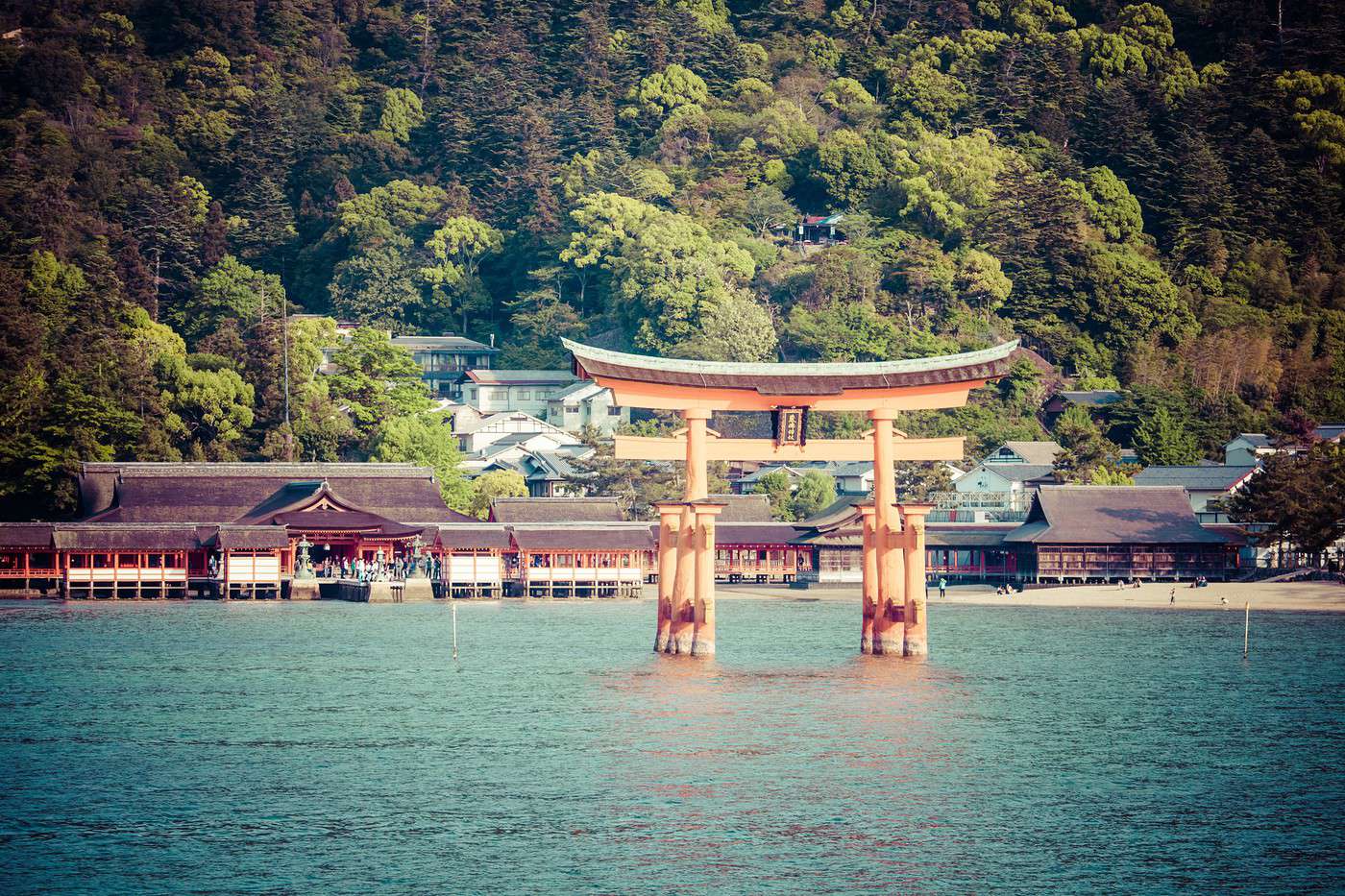
Ile d'Itsukushima, Japon
Ile d'Itsukushima, Japon · © VoyageForum

The island, between Honshu and Kyushu, isn’t heavily visited by foreign tourists. With fewer dramatic landscapes despite its distinct terrain, fewer cities, and fewer outdoor activity options, Shikoku offers a different side of Japan. Still, it boasts several natural sites where the sea and mountains meet (Ashizuri-Uwakai Park, Sadamisaki Peninsula, etc.), as well as significant religious heritage, notably the Shikoku 88 Temple Pilgrimage, a pilgrimage route that spans the entire island.

Key Facts

  • Type of place: tourist region.
  • Location: It’s the island located in the southern part of the archipelago, between Honshu and Kyushu.
  • Local time: Heure : Shikoku
  • Main cities: Imabari, Kochi, Matsuyama, Saijo, Takamatsu, Tokushima...
  • Population: 3,858,000 inhabitants (2015).
  • Area: 18,803 km².
  • Density: 205 inhabitants/km².
  • Lowest point: sea level.
  • Coastline:
  • Highlights (out of ): Nature / ; Adventure / ; Culture ; Relaxation/Holidays
  • Website:

Main Cities

Tourist Attractions

Cities and Heritage

Beaches and Coastline

Nature and Activities

Climate and Weather in Matsuyama

Seto Inland Sea Islands

These are the many small islands between Shikoku and Honshu. You can hike on some or visit temples on others, starting with the sacred UNESCO-listed island of Itsukushima. Alongside it, Shodoshima (the Olive Island) and Naoshima (with its contemporary art installations) are the most tourist-friendly.

Overview of the Seto Inland Sea Islands

These are the many small islands between Shikoku and Honshu located in the Seto Inland Sea (also simply called the Inland Sea). You can hike on some or visit temples on others, starting with the sacred UNESCO-listed island of Itsukushima. Alongside it, Shodoshima (the Olive Island) and Naoshima (with its contemporary art installations) are the most tourist-friendly.

Key Facts

  • Type of place: archipelago.
  • Tourist interest: (worth seeing).
  • Location:
  • Local time: Heure : 20974
  • Number of islands:
  • Population:
  • Area:
  • Highest point:
  • Website:

Main Islands

  • Itsukushima: also called Miyajima, this is a sacred Shinto island listed as a UNESCO World Heritage site. Besides several temples, it is home to one of Japan’s most famous landmarks, the "floating torii" (traditional gate).
  • Naoshima:
  • Shodoshima:

History of the Seto Inland Sea Islands

Environment of the Archipelago

Wildlife and Flora

Precautions

What to See and Do

In the Area

Climate and Weather

Transportation

Getting There

Getting Around

Accommodation

Food

Useful Addresses

  1. == Additional Information
View guide page: Seto Inland Sea Islands

Itsukushima Island

Also known as Miyajima, this is a sacred Shinto island designated as a UNESCO World Heritage site. In addition to several temples, it is home to one of Japan's most famous landmarks, the "floating torii" (traditional gate).

Overview of Itsukushima Island

Also known as Miyajima (after the main town), this is a sacred Shinto island designated as a UNESCO World Heritage site. In addition to several temples, it is home to one of Japan's most famous landmarks in Japan, the "floating torii" (traditional gate).

Key Facts

  • Type of place: island.
  • Tourist interest: (recommended).
  • Location:
  • Local time: Heure : 20974
  • Main locality: Miyajima.
  • Population:
  • Area: 30.39 km².
  • Highest point: Mount Misen (530 m).
  • Coastline:

History of Itsukushima Island

Island Environment

Wildlife and Flora

Precautions

What to See and Do on Itsukushima Island

In the Surrounding Area

Climate and Weather

Transportation

Getting There

Getting Around

Accommodation

Food

Useful Addresses

Additional Information

View guide page: Itsukushima Island

Kochi (Japan)

A large city known for its beautiful 17th-century castle and several museums. There are also several beaches in the surrounding area, as well as the stunning Ryugado Caves.

Overview of Kochi

A large city known for its beautiful 17th-century castle and several museums. There are also several beaches in the surrounding area, as well as the stunning Ryugado Caves.

Key Facts

  • Type de lieu: city.
  • Intérêt touristique: (worth a stop if you are in the area).
  • Localisation:
  • Distances:
  • Heure locale: Heure : 20975.
  • Population: 331,843 (2018).
  • Superficie: 309 km².
  • Altitude: sea level.

History of Kochi

What to See and Do in Kochi

In the Surrounding Area

Climate and Weather in Kochi

Transportation

Getting There

Getting Around

Accommodation

Food

Useful Addresses

  1. == Further Information
View guide page: Kochi (Japan)

Kotohira

Cette grosse bourgade abrite un des principaux sanctuaire shinto du pays.

Présentation de Kotohira

Cette grosse bourgade abrite un des principaux sanctuaire shinto du Japan.

Repères

  • Type de lieu: small town.
  • Intérêt touristique: (worth a stop if you are in the area).
  • Localisation:
  • Distances:
  • Heure locale: Heure : 20976.
  • Population: 8 772 habitants (2018).
  • Superficie: 8,47 km².
  • Altitude:

Histoire de Kotohira

À voir, à faire à Kotohira

Dans les environs

Climat et météo de Kotohira

Transports

S'y rendre

S'y déplacer

Dormir

Manger

Adresses utiles

En complément

View guide page: Kotohira

Mount Ishizuchi

The summit of Shikoku Island (1,982 m) has become a classic for many visitors/pilgrims who climb it to reach the small temple built there.

Overview of Mount Ishizuchi

The summit of Shikoku Island (1,982 m) has become a classic for many visitors/pilgrims who climb it to reach the small temple built there.

Key details

  • Type of place: mountain.
  • Tourist interest: (worth seeing).
  • Features:
  • Mountain range:
  • Summit: 1,982 m.

Mount Ishizuchi’s surroundings

Wildlife and flora

Climate and weather

Precautions

What to see and do

Practical information

  • Location:
  • Distances:
  • Website:

Getting there

Accommodation and dining

Nearby attractions

  1. == En complément
View guide page: Mount Ishizuchi

Matsuyama

Main urban area of Shikoku Island, known for its castles, temples along the "88 Temple Pilgrimage Route", museums, and baths.

Overview of Matsuyama

The main urban area of Shikoku Island, featuring castles, temples for pilgrims on the "Shikoku 88 Temple Pilgrimage", museums, and baths.

Key Facts

  • Type of place: large city.
  • Tourist interest: (worth a stop if you are in the area).
  • Location:
  • Distances:
  • Local time: Heure : 20978.
  • Population: 510,809 (2018).
  • Area: 429.40 km².
  • Altitude:

History of Matsuyama

What to See and Do in Matsuyama

In the Surrounding Area

Climate and Weather in Matsuyama

Transportation

Getting There

Getting Around

Accommodation

Dining

Useful Addresses

Additional Information

View guide page: Matsuyama

Shikoku 88 Temple Pilgrimage

This name refers to a pilgrimage (1,200 km long!) that spans the entire island of Shikoku and includes 88 temples to visit among the most beautiful in the country.

Overview of the Shikoku 88 Temple Pilgrimage

This name refers to a pilgrimage (1,200 km long!) that spans the entire island of Shikoku and includes 88 temples to visit among the most beautiful in Japan. Doable on foot, it’s somewhat the Japanese equivalent of the Camino de Santiago.

Key Details

  • Type of place: scenic route.
  • Tourist interest: (recommended).
  • Theme:
  • Location:
  • Local time: Heure : 20979
  • Main towns:
  • Length: approximately 1,200 km.

The Route

What to See and Do

Itinerary

Nearby Attractions

Climate and Weather

Transportation

Getting There

Getting Around

Accommodation

Food

Additional Information

View guide page: Shikoku 88 Temple Pilgrimage

Takamatsu

The city is best known for its gardens, including the stunning Ritsurin-ko-en. On its outskirts, Yashima-ji is a beautiful temple that forms part of the "88 Temple Pilgrimage Route".

Overview of Takamatsu

The city is best known for its gardens, including the stunning Ritsurin-ko-en. On its outskirts, Yashima-ji is a beautiful temple that forms part of the "Shikoku 88 Temple Pilgrimage".

Key Facts

  • Type of place: city.
  • Tourist interest: (worth a stop if you are in the area).
  • Location:
  • Distances:
  • Local time: Heure : 20980.
  • Population: 418,122 inhabitants (2018).
  • Area: 375.41 km².
  • Altitude: sea level.

History of Takamatsu

What to See and Do in Takamatsu

In the Surrounding Area

Climate and Weather in Takamatsu

Transportation

Getting There

Getting Around

Accommodation

Dining

Useful Addresses

Further Reading

View guide page: Takamatsu

Tokushima

A city with several temples on the "88 Temples Pilgrimage Route", a castle, and a renowned dance festival (Awa-Odori). The coast and its beaches south of the city are pleasant.

Overview of Tokushima

This is a city with several temples on the "Shikoku 88 Temple Pilgrimage", a castle, and a renowned dance festival (Awa-Odori). The coast and its beaches south of the city are pleasant.

Key Facts

  • Type of place: city.
  • Tourist interest: (worth a stop if you are in the area).
  • Location:
  • Distances:
  • Local time: Heure : 20981.
  • Population: 256,766 inhabitants (2018).
  • Area: 191.39 km².
  • Altitude: sea level.

History of Tokushima

What to See and Do in Tokushima

Nearby

Climate and Weather in Tokushima

Transportation

Getting There

Getting Around

Accommodation

Food

Useful Addresses

Further Information

View guide page: Tokushima

Uwajima

This seaside town is known for its 16th-century castle and bullfighting.

Overview of Uwajima

This seaside town is known for its 16th-century castle and bullfighting.

Key facts

  • Type of place: city.
  • Tourist interest: (worth a stop if you are in the area).
  • Location:
  • Distances:
  • Local time: Heure : 20982.
  • Population: 73,380 inhabitants (2018).
  • Area: 468.19 km².
  • Altitude: sea level.

History of Uwajima

What to see and do in Uwajima

In the surrounding area

Climate and weather in Uwajima

Transport

Getting there

Getting around

Accommodation

Food

Useful addresses

  1. == Further information
View guide page: Uwajima

Ashizuri-Uwakai National Park

This is the southern tip of the island, formed by Ashizuri Cape. Here, you’ll find a beautiful coastal landscape with numerous cliffs.

Overview of Ashizuri-Uwakai Park

This is the southern tip of the island of Shikoku, formed by Ashizuri Cape. Here, you’ll find a beautiful coastal landscape with numerous cliffs.

Key Details

  • Type of place: national park.
  • Tourist interest: (worth seeing).
  • Features:
  • Local time: Heure : 20983
  • Annual visitors:
  • Area: 111.66 km².
  • Altitude: sea level

Environment

Park Landscape

Wildlife and Flora

Climate and Weather

Precautions

What to See

What to Do

Practical Information

  • Location:
  • Distances:
  • Opening period:
  • Rates:

Getting There

Getting Around

Accommodation and Dining

Nearby Attractions

  1. == Further Reading
View guide page: Ashizuri-Uwakai National Park

Sadamisaki Peninsula

The longest peninsula in Japan offers some beautiful landscapes (despite the presence of a nuclear power plant) where mountains and coastline meet.

Overview of the Sadamisaki Peninsula

The longest peninsula in Japan offers some beautiful landscapes (despite the presence of a nuclear power plant) where mountains and coastline meet.

Key Facts

  • Type of place: peninsula.
  • Tourist interest: (worth a stop if you are in the area).
  • Location:
  • Area:
  • Length: approximately 40 km.
  • Highest point:
  • Website:

Environment of the Peninsula

Wildlife and Flora

What to See and Do

Nearby

Climate and Weather

Precautions

Transportation

Getting There

Getting Around

Sleeping and Eating

  1. == En complément
View guide page: Sadamisaki Peninsula

Naruto Whirlpools

Located off the coast of the city of the same name, this is an impressive natural phenomenon caused by tidal interactions in the Naruto Strait. It can be seen twice a day and is a popular local attraction.

Overview of the Naruto Whirlpools

Located off the coast of the city of the same name, this is an impressive natural phenomenon caused by tidal interactions in the Naruto Strait. It can be seen twice a day and is a popular local attraction.

Key Details

  • Type of place: geyser.
  • Tourist interest: (worth a stop if you are in the area).
  • Features:
  • Location:

Surroundings

What to See and Do

Practical Information

Getting There

Accommodation and Dining

Nearby Attractions

  1. == In addition
View guide page: Naruto Whirlpools

Iya Valley

This is a stunning, secluded valley deep in the island’s heart, known for its challenging access. Many visitors come here to hike and cross the vine bridges spanning the gorges. The Oboke and Koboke rivers are internationally renowned for rafting.

Overview of Iya Valley

This is a stunning, secluded valley deep in the heart of Shikoku, known for its challenging access. Many visitors come here to hike and cross the vine bridges spanning the gorges. The Oboke and Koboke rivers are internationally renowned for rafting.

Key Details

  • Type of place: valley.
  • Tourist interest: (worth seeing).
  • Features:
  • Length:
  • Altitude:

Valley Environment

Wildlife and Flora

Climate and Weather

Precautions

Things to See and Do

Practical Information

  • Location:
  • Distances:

Getting There

Getting Around

Accommodation and Dining

Nearby Attractions

Further Reading

View guide page: Iya Valley

Something wrong or out of date? Report this page