Skip to content
What to See in Panama

Travel guide · Panama

What to See in Panama

last edited Dec 11, 2019

UNESCO World Heritage Sites

Panama has 7 sites inscribed on the UNESCO World Heritage list.
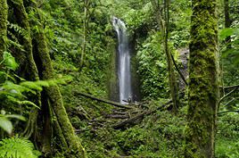
Parc national La Amistad, Costa Rica
La Amistad National Park (1983)
Spanning both Panama and Costa Rica, the site is a UNESCO World Heritage Site. It boasts rich plant diversity and offers numerous trekking opportunities.
Parc national de Coiba, Panama
Coiba National Park (2005)
This park, formed by Coiba Island, is a UNESCO World Heritage site. The area is ideal for diving and is also home to whales, turtles, sharks, and more.
Parc national du Darien, Panama
Darien National Park (1981)
A UNESCO World Heritage Site, this vast park bordering Colombia is rich in wildlife and plant life. Like almost the entire Darien region, it requires certain safety precautions.
Centre historique de Panama City, Panama Ciudad, Panama
Historic Centre of Panama City (1997)
This is the district called Casco Viejo, which, along with the city's archaeological zone (Panama Viejo), is a UNESCO World Heritage site for its historical value and, above all, its distinctive Spanish-era architecture.
Zone archéologique, Panama Ciudad, Panama
Archaeological Zone of Panama City (1997)
On the outskirts of the modern city, Panama Viejo—as it is known—is a testament to the very first Spanish and European settlement (in 1519) on the Pacific coast of the Americas.
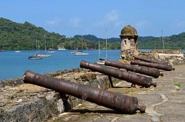
Forteresse de Portobelo, Panama
Portobelo Fortress (1980)
This late 16th-century Spanish fortress is a UNESCO World Heritage Site, much like the nearby San Lorenzo fortress in the Colon area.
Forteresse San Lorenzo, Panama
Fortress of San Lorenzo (1980)
This 16th-century Spanish fortress is a UNESCO World Heritage site, much like the one in Portobelo, also located near Colón.

The West

Bocas del Toro, Panama
Bocas del Toro
Though things are slowly changing, Bocas del Toro remains a stunning Caribbean archipelago with beautiful beaches and opportunities for diving or cycling. Colón is the main island, while Bastimentos is the most peaceful, as much of it is classified as a national park.
Boquete, Panama
Boquete
A small town in the heart of the mountains near Costa Rica. It's an excellent base for exploring the surrounding area (Baru Volcano, La Amistad Park, coffee plantations) and especially for enjoying various outdoor activities (trekking, horseback riding, climbing, rafting).
David, Panama
David
This city near Costa Rica is primarily a "quiet" stopover or a starting point for exploring the surrounding area.
Islands of the Gulf of Chiriquí
This Pacific gulf, bordering Costa Rica, is renowned for fishing. It shelters several islands (Palenque, Secas, Boca Brava, Ladrones), accessible from the village of Boca Chica, offering beautiful beaches and opportunities for diving and whale watching from August to October.
Pedasí
A small town in Azuero known for its carnival, beaches, fishing, diving, and surfing.
Péninsule d'Azuero, Panama
Azuero Peninsula
This broad stretch of land separating the Gulf of Chiriquí from the Gulf of Panama is prized for its beaches, fishing, surfing, and peaceful villages.
Santa Catalina, Santa Catalina, Panama
Santa Catalina
This small seaside resort facing Coiba Island is renowned for its beaches, fishing, diving, and surfing.

Natural Heritage

Parc national La Amistad, Costa Rica
La Amistad National Park
Spanning both Panama and Costa Rica, the site is a UNESCO World Heritage Site. It boasts rich plant diversity and offers numerous trekking opportunities.
Parc national de Coiba, Panama
Coiba National Park
This park, formed by Coiba Island, is a UNESCO World Heritage site. The area is ideal for diving and is also home to whales, turtles, sharks, and more.
Volcan Baru, Panama
Baru Volcano
This volcano near the town of Boquete is the country’s highest peak and is designated as a national park. It can be reached by hiking.

The Centre

Canal de Panama, Panama
Panama Canal
Connecting the Pacific to the Atlantic, it’s the "must-see" of any visit to the country, particularly worth discovering at its locks, such as Miraflores or Gatun.
Colon, Panama
Colón
At the entrance to the canal, on the Caribbean side, the city has a rather poor reputation and isn’t necessarily very attractive. Commercially, however, Colón is a duty-free zone.
El Valle, Panama
El Valle
A small high-altitude town on the slopes of a volcano, southwest of Panama City, known for serving as a base for hiking exploration in the area or birdwatching.
Gamboa, Panama
Gamboa
Not far from the capital and on the edge of the forest, this former municipality in the Canal Zone now serves as a starting point for birdwatching hikes in the area.
Forteresse San Lorenzo, Panama
Fortress of San Lorenzo
This 16th-century Spanish fortress is a UNESCO World Heritage site, much like the one in Portobelo, also located near Colón.
Panama Ciudad, Panama
Panama City
With its archaeological zone and UNESCO-listed old town, its modern district, the Canal, and its museums, Panama City is one of the most interesting cities in Latin America.
Portobelo, Panama
Portobelo
This Caribbean port with fairly beautiful beaches is a UNESCO World Heritage Site for its Spanish fortress. It’s also a departure point for boats to the San Blas Islands, among others.
Taboga, Panama
Taboga
A lovely small island about twenty kilometres from the capital. Quite touristy, it’s popular for its beaches and hiking.

Natural Heritage

Parc national Chagres, Panama
Chagres National Park
East of the canal, this vast protected forest area is home to several Indigenous communities that partly rely on tourism. You can also observe many bird species or go rafting on the Chagres River.
Soberanía National Park
This vast forested area between Panama City and Gatun Lake is renowned for its birdlife. Hiking, including birdwatching tours, can be done from Gamboa.

The East

Warning: The entire Darien region bordering Colombia is currently either completely or strongly advised against by the French Ministry of Foreign Affairs due to security concerns.

Darien, Panama
Darién
This is the vast expanse of swamps and forests between Panama and Colombia that blocks any overland route between the two countries. For decades, Darién has also not been considered very safe.
Las Perlas, Panama
Pearl Islands
An archipelago of over 200 islands in the Gulf of Panama, the largest being Isla del Rey and the most tourist-oriented Contadora. The area is renowned for its beaches and opportunities for diving or fishing.
Puerto Obaldia, Panama
Puerto Obaldia
This Caribbean town is the gateway for those heading to Colombia by taking a small boat to Capurgana and then continuing from there to the town of Turbo.
San Blas, Panama
San Blas
On Panama’s northeast coast, the archipelago is known as the home of the Kuna people, whose traditions remain very much alive. It boasts stunning beaches and great snorkeling opportunities.

Natural Heritage

Parc national du Darien, Panama
Darien National Park
A UNESCO World Heritage Site, this vast park bordering Colombia is rich in wildlife and plant life. Like almost the entire Darien region, it requires certain safety precautions.

Must-see & highly recommended

★★★★

Bocas del Toro

Though things are slowly changing, Bocas del Toro remains a stunning Caribbean archipelago with beautiful beaches and opportunities for…
★★★★

Panama Canal

Connecting the Pacific to the Atlantic, it’s the "must-see" of any visit to the country, particularly worth discovering at its locks…
★★★★

Historic Centre of Panama City

This is the district called Casco Viejo, which, along with the city's archaeological zone (Panama Viejo), is a UNESCO World Heritage site…
★★★★

Panama City

With its archaeological zone and UNESCO-listed old town, its modern district, the Canal, and its museums, Panama City is one of the most…

Recommended

★★★

Pearl Islands

An archipelago of over 200 islands in the Gulf of Panama, the largest being Isla del Rey and the most tourist-oriented Contadora. The area…
★★★

San Blas

On Panama’s northeast coast, the archipelago is known as the home of the Kuna people, whose traditions remain very much alive. It…

Worth a look / Other

★★

Darién

This is the vast expanse of swamps and forests between Panama and Colombia that blocks any overland route between the two countries. For…
★★

Portobelo Fortress

This late 16th-century Spanish fortress is a UNESCO World Heritage Site, much like the nearby San Lorenzo fortress in the Colon area.
★★

Fortress of San Lorenzo

This 16th-century Spanish fortress is a UNESCO World Heritage site, much like the one in Portobelo, also located near Colón.
★★

Islands of the Gulf of Chiriquí

This Pacific gulf, bordering Costa Rica, is renowned for fishing. It shelters several islands (Palenque, Secas, Boca Brava, Ladrones)…
★★

Chagres National Park

East of the canal, this vast protected forest area is home to several Indigenous communities that partly rely on tourism. You can also…
★★

Coiba National Park

This park, formed by Coiba Island, is a UNESCO World Heritage site. The area is ideal for diving and is also home to whales, turtles…
★★

Soberanía National Park

This vast forested area between Panama City and Gatun Lake is renowned for its birdlife. Hiking, including birdwatching tours, can be done…
★★

Darien National Park

A UNESCO World Heritage Site, this vast park bordering Colombia is rich in wildlife and plant life. Like almost the entire Darien region…
★★

La Amistad National Park

Spanning both Panama and Costa Rica, the site is a UNESCO World Heritage Site. It boasts rich plant diversity and offers numerous trekking…
★★

Azuero Peninsula

This broad stretch of land separating the Gulf of Chiriquí from the Gulf of Panama is prized for its beaches, fishing, surfing, and…
★★

Portobelo

This Caribbean port with fairly beautiful beaches is a UNESCO World Heritage Site for its Spanish fortress. It’s also a departure…
★★

Santa Catalina (Panama)

This small seaside resort facing Coiba Island is renowned for its beaches, fishing, diving, and surfing.
★★

Taboga

A lovely small island about twenty kilometres from the capital. Quite touristy, it’s popular for its beaches and hiking.
★★

Baru Volcano

This volcano near the town of Boquete is the country’s highest peak and is designated as a national park. It can be reached by hiking.
★★

Archaeological Zone of Panama City

On the outskirts of the modern city, Panama Viejo—as it is known—is a testament to the very first Spanish and European…
★

Boquete

A small town in the heart of the mountains near Costa Rica. It's an excellent base for exploring the surrounding area (Baru Volcano, La…
★

Colón

At the entrance to the canal, on the Caribbean side, the city has a rather poor reputation and isn’t necessarily very attractive…
★

David

This city near Costa Rica is primarily a "quiet" stopover or a starting point for exploring the surrounding area.
★

El Valle

A small high-altitude town on the slopes of a volcano, southwest of Panama City, known for serving as a base for hiking exploration in the…
★

Gamboa

Not far from the capital and on the edge of the forest, this former municipality in the Canal Zone now serves as a starting point for…
★

Pedasí

A small town in Azuero known for its carnival, beaches, fishing, diving, and surfing.
★

Puerto Obaldia

This Caribbean town is the gateway for those heading to Colombia by taking a small boat to Capurgana and then continuing from there to the…

Coiba National Park

This park, formed by Coiba Island, is a UNESCO World Heritage site. The area is ideal for diving and is also home to whales, turtles, sharks, and more.

Overview of Coiba National Park

This park, formed by Coiba Island, is a UNESCO World Heritage site. The area is ideal for diving and is also home to whales, turtles, sharks, and more.

Key details

  • Type of place: national park.
  • Tourist interest: (worth seeing).
  • Features:
  • Local time: Heure : 3323
  • Annual visitors:
  • Area: 503 km².
  • Altitude: sea level.

Environment

Landscape of the park

Wildlife and flora

Climate and weather

Precautions

What to see

What to do

Practical information

  • Location:
  • Distances:
  • Opening period:
  • Rates:

Getting there

Getting around

Accommodation and dining

What to see nearby

Additional information

View guide page: Coiba National Park

Darién

This is the vast expanse of swamps and forests between Panama and Colombia that blocks any overland route between the two countries. For decades, Darién has also not been considered very safe.

Overview of Darién

This is the vast expanse of swamps and forests between Panama and Colombia that blocks any overland route between the two countries. For decades, Darién has also not been considered very safe.

Key Facts

  • Type of place: territorial subdivision.
  • Tourist interest: (worth seeing).
  • Location:
  • Local time: Heure : 3324
  • Main town: La Palma (approx. 4,500 inhabitants).
  • Population: 55,346 inhabitants (2016).
  • Area: 11,892 km².
  • Density: 4.6 inhabitants/km².
  • Highest point: 2,280 m.
  • Lowest point: sea level.
  • Coastline:

Climate and Weather

Main Towns

Tourist Attractions

Towns and Heritage

Beaches and Coastline

Nature and Activities

Further Information

View guide page: Darién

Panama City

With its archaeological zone and UNESCO-listed old town, its modern district, the Canal, and its museums, Panama City is one of the most interesting cities in Latin America. Overview of Panama City Climate and Weather in Panama City What to see in Panama City Things to Do in Panama City Flying to Panama City Getting to Panama City by Land or Sea Getting Around Panama City Sleeping and Eating in Panama City Living in Panama City
Panama Ciudad, Panama
Panama Ciudad, Panama · © VoyageForum

Further Information

View guide page: Panama City

Overview of Panama City

Overview of Panama City

With its UNESCO-listed archaeological zone and old town, its modern district, its Canal, and its museums, Panama City is one of the most interesting cities in Latin America.

Key Details

  • Type of place: large city.
  • Tourist interest: (must-see or highly recommended).
  • Location:
  • Distances:
  • Local time: Heure : 3325.
  • Population: 880,691 inhabitants (2013).
  • Area: 275 km².
  • Altitude: sea level.

History of Panama City

Precautions

Useful Addresses

  • Tourist Office:

Services

  • Local agencies:
  • Banks:
  • Hospital:
  • Internet:
  • Laundries:
  • Vehicle rental:
  • Post office:
View guide page: Overview of Panama City

Climate and Weather in Panama City

Climate Overview

Best Time to Visit Panama City

Jan.Feb.Mar.Apr.MayJun.Jul.Aug.Sep.Oct.Nov.Dec.
Climate

Climate and Forecast

Additional Information

View guide page: Climate and Weather in Panama City

What to see in Panama City

Overview

UNESCO World Heritage Sites

Centre historique de Panama City, Panama Ciudad, Panama
Historic Centre of Panama City (1997)
This is the district called Casco Viejo, which, along with the city's archaeological zone (Panama Viejo), is a UNESCO World Heritage site for its historical value and, above all, its distinctive Spanish-era architecture.
Zone archéologique, Panama Ciudad, Panama
Archaeological Zone of Panama City (1997)
On the outskirts of the modern city, Panama Viejo—as it is known—is a testament to the very first Spanish and European settlement (in 1519) on the Pacific coast of the Americas.

Neighborhoods

Sites, monuments and architectural ensembles

Religious buildings

Museums

Parks and gardens

In the surrounding area

Further reading

View guide page: What to see in Panama City

Historic Centre of Panama City

This is the district called Casco Viejo, which, along with the city's archaeological zone (Panama Viejo), is a UNESCO World Heritage site for its historical value and, above all, its distinctive Spanish-era architecture.

Overview of the historic centre

This is the district called Casco Viejo, which, along with the archaeological zone of the city (Panama Viejo), is a UNESCO World Heritage site for its historical value and, above all, its distinctive Spanish-era architecture.

  • Tourist interest: (must-see or highly recommended).

History of Casco Viejo

What to see

What to do

Events and entertainment

Practical information

  • Location:
  • How to get there:
  • How to get around:

Eating

Sleeping

What to see nearby

  1. == To complement
View guide page: Historic Centre of Panama City

Archaeological Zone of Panama City

On the outskirts of the modern city, Panama Viejo—as it is known—is a testament to the very first Spanish and European settlement (in 1519) on the Pacific coast of the Americas.

Overview of the Site

On the outskirts of the modern city, Panama Viejo—as it is known—is a testament to the very first Spanish and European settlement (in 1519) on the Pacific coast of the Americas. It is a UNESCO World Heritage site, along with Historic Centre of Panama City.

  • Type of place: historic remains.
  • Tourist interest: (worth seeing).
  • Features:
  • Area:
  • Altitude: sea level.

History of Panama Viejo

What to See and Do

Practical Information

  • Location:
  • Address:
  • Opening hours:
  • Price:
  • How to get there:

Nearby Attractions

  1. == En complément
View guide page: Archaeological Zone of Panama City

Flying to Panama City

Panama City Airport

Panama City has one of the most important airports in Latin America thanks to Tocumen and its 15 million passengers per year. While it handles the vast majority of the capital's air traffic, the city also has two other small airports: Albrook (domestic flights only) and Panama Pacifico (flights to/from Colombia only).

Tocumen Airport in detail

  • Name: Aeropuerto Internacional de Tocumen.
  • IATA code: PTY
  • Hub:
  • Number of terminals:
  • Annual passenger capacity:
  • Passenger traffic: 15,616,065 (2017).
  • Distance from city centre: 24 km northeast of the city.

Services

Sleeping at the airport

Transport to the city centre

Other nearby airports

From the rest of Panama

From the rest of the Americas

From Europe

From elsewhere

Additional information

View guide page: Flying to Panama City

Portobelo

This Caribbean port with fairly beautiful beaches is a UNESCO World Heritage Site for its Spanish fortress. It’s also a departure point for boats to the San Blas Islands, among others.

Overview of Portobelo

This Caribbean port with fairly beautiful beaches is a UNESCO World Heritage Site for its Spanish fortress. It’s also a departure point for boats to the San Blas Islands.

Key Details

  • Type of place: small town.
  • Tourist interest: (worth seeing).
  • Location:
  • Distances:
  • Local time: Heure : 3326.
  • Population: 4,559 inhabitants (2010).
  • Area: 244.7 km².
  • Altitude: sea level.

History of Portobelo

What to See and Do in Portobelo

Forteresse de Portobelo, Panama
Portobelo Fortress
This late 16th-century Spanish fortress is a UNESCO World Heritage Site, much like the nearby San Lorenzo fortress in the Colon area.

In the Surrounding Area

Climate and Weather in Portobelo

Transportation

Getting There

Getting Around

Accommodation

Food

Useful Addresses

Further Reading

View guide page: Portobelo

Portobelo Fortress

This late 16th-century Spanish fortress is a UNESCO World Heritage Site, much like the nearby San Lorenzo fortress in the Colon area.

Overview of Portobelo Fortress

This late 16th-century Spanish fortress is a UNESCO World Heritage Site, much like the nearby San Lorenzo fortress in the Colón area.

  • Tourist interest: (worth seeing).

History of Portobelo Fortress

What to see and do

Practical information

  • Location:
  • Local time: Heure : 9482.
  • Address: Portobelo, Panama.
  • Opening hours:
  • Admission fee:
  • Website:

Transport

Accommodation and dining

Nearby attractions

  1. == In addition
View guide page: Portobelo Fortress

Fortress of San Lorenzo

This 16th-century Spanish fortress is a UNESCO World Heritage site, much like the one in Portobelo, also located near Colón.

Overview of San Lorenzo

This 16th-century Spanish fortress is a UNESCO World Heritage site, much like Portobelo, which is also located near Colón.

  • Tourist interest: (worth seeing).

History of San Lorenzo

What to see and do

Practical information

  • Location:
  • Local time: Heure : 3327.
  • Address: Colón, Panama.
  • Opening hours:
  • Price:

Transport

Sleeping and eating

What to see nearby

Additional information

View guide page: Fortress of San Lorenzo

Boquete

A small town in the heart of the mountains near Costa Rica. It's an excellent base for exploring the surrounding area (Baru Volcano, La Amistad Park, coffee plantations) and especially for enjoying various outdoor activities (trekking, horseback riding, climbing, rafting).

Overview of Boquete

It's a small town in the heart of the mountains near Costa Rica. It's an excellent base for exploring the surrounding area (Baru Volcano, La Amistad Park, coffee plantations) and especially for enjoying various outdoor activities (trekking, horseback riding, climbing, rafting).

Key Facts

  • Type de lieu: small town.
  • Intérêt touristique: (worth a stop if you are in the area).
  • Localisation:
  • Distances:
  • Heure locale: Heure : 3329.
  • Population: 4,493 inhabitants (2011).
  • Superficie: 18.2 km².
  • Altitude: 1,200 m.

History of Boquete

What to See and Do in Boquete

In the Surrounding Area

Climate and Weather in Boquete

Transportation

Getting There

Getting Around

Where to Stay

Where to Eat

Useful Addresses

Additional Information

View guide page: Boquete

David

This city near Costa Rica is primarily a "quiet" stopover or a starting point for exploring the surrounding area.

Overview of David

This city near Costa Rica is primarily a "quiet" stopover or a starting point for exploring the surrounding area.

Key Facts

  • Type of place: city.
  • Tourist interest: (worth a stop if you are in the area).
  • Location:
  • Distances:
  • Local time: Heure : 3330.
  • Population: 144,858 inhabitants (2013)
  • Area: 176 km².
  • Altitude: 10 m.

History of David

What to See and Do in David

In the Surrounding Area

Climate and Weather in David

Transportation

Getting There

Getting Around

Accommodation

Dining

Useful Addresses

Additional Information

View guide page: David

El Valle

A small high-altitude town on the slopes of a volcano, southwest of Panama City, known for serving as a base for hiking exploration in the area or birdwatching.

Introduction to El Valle

It's a small high-altitude town on the slopes of a volcano, southwest of Panama City, known for serving as a base for hiking exploration in the area or birdwatching.

Key Facts

  • Type of place: small town.
  • Tourist interest: (worth a stop if you are in the area).
  • Location:
  • Distances:
  • Local time: Heure : 3331.
  • Population: 7,602 inhabitants (2010).
  • Area: 34.8 km².
  • Altitude: 588 m.

History of El Valle

What to See and Do in El Valle

In the Surrounding Area

Climate and Weather in El Valle

Transportation

Getting There

Getting Around

Accommodation

Eating Out

Useful Addresses

Additional Information

View guide page: El Valle

Azuero Peninsula

This broad stretch of land separating the Gulf of Chiriquí from the Gulf of Panama is prized for its beaches, fishing, surfing, and peaceful villages.

Overview of the Azuero Peninsula

This broad stretch of land separating the Gulf of Chiriquí from the Gulf of Panama is prized for its beaches, fishing, surfing, and peaceful villages.

Key Facts

  • Type of place: peninsula.
  • Tourist interest: (worth seeing).
  • Location:
  • Local time: Heure : 3333.
  • Area: 8,000 km².
  • Altitude:

Environment of the Azuero Peninsula

Wildlife and flora

What to see and do

In the surrounding area

Climate and weather

Precautions

Getting around

Getting there

Getting around locally

Accommodation and dining

Further information

View guide page: Azuero Peninsula

Baru Volcano

This volcano near the town of Boquete is the country’s highest peak and is designated as a national park. It can be reached by hiking.

Overview of Baru Volcano

This volcano near the town of Boquete is Panama’s highest peak and is designated as a national park. It can be reached by hiking.

Key Details

  • Type of place: volcano.
  • Tourist interest: (worth seeing).
  • Features:
  • Massif:
  • Summit: 3,475 m.

Environment of Baru Volcano

Wildlife and vegetation

Climate and weather

Precautions

What to see and do

Practical information

  • Location:
  • Distances:
  • Website:

Getting there

Accommodation and dining

Nearby attractions

Additional information

View guide page: Baru Volcano

Panama Canal

Connecting the Pacific to the Atlantic, it’s the "must-see" of any visit to the country, particularly worth discovering at its locks, such as Miraflores or Gatun.

Overview of the Panama Canal

Connecting the Pacific (Panama City) to the Atlantic (Colón), it’s the "must-see" of any visit to the country. It’s particularly worth discovering at its locks, such as Miraflores or Gatun.

Key Facts

  • Type of place: canal.
  • Tourist interest: (must-see or highly recommended).
  • Features:
  • Length: 77 km.
  • Altitude: sea level.

Canal Environment

What to See

What to Do

Practical Information

  • Location:

Getting There

Sleeping and Eating

What to See Nearby

Additional Information

View guide page: Panama Canal

Colón

At the entrance to the canal, on the Caribbean side, the city has a rather poor reputation and isn’t necessarily very attractive. Commercially, however, Colón is a duty-free zone.

Overview of Colón

At the entrance to the Canal, on the Caribbean side, the city has a rather poor reputation and isn’t necessarily very attractive. Commercially, however, Colón is a duty-free zone.

Key Facts

  • Type of place: city.
  • Tourist interest: (worth a stop if you are in the area).
  • Location:
  • Distances:
  • Local time: Heure : 3337.
  • Population: 78,000 inhabitants (2011).
  • Area: 2.4 km².
  • Altitude: sea level.

History of Colón

What to See and Do in Colón

In the Surrounding Area

Climate and Weather in Colón

Transportation

Getting There

Getting Around

Accommodation

Eating Out

Useful Addresses

Additional Information

View guide page: Colón

Taboga

A lovely small island about twenty kilometres from the capital. Quite touristy, it’s popular for its beaches and hiking.

Overview of Taboga

It’s a lovely small island about twenty kilometres from the capital. Quite touristy, it’s popular for its beaches and hiking.

Key Facts

  • Type of place: island.
  • Tourist interest: (worth seeing).
  • Location:
  • Local time: Heure : 3338
  • Main locality:
  • Population: 1,629 inhabitants (2012).
  • Area: 12.1 km².
  • Highest point:
  • Coastline:

History of Taboga

Island Environment

Wildlife and Flora

Precautions

What to See and Do in Taboga

In the Surrounding Area

Climate and Weather in Taboga

Transport

Getting There

Getting Around

Accommodation

Food

Useful Addresses

Further Information

View guide page: Taboga

Pearl Islands

An archipelago of over 200 islands in the Gulf of Panama, the largest being Isla del Rey and the most tourist-oriented Contadora. The area is renowned for its beaches and opportunities for diving or fishing.

Overview of the Pearl Islands

This is an archipelago of over 200 islands and islets in the Gulf of Panama, the largest being Isla del Rey and the most tourist-oriented Contadora. The area is renowned for its beaches and opportunities for diving or fishing.

Key Facts

  • Type of place: archipelago.
  • Tourist interest: (recommended).
  • Location:
  • Local time: Heure : 3339
  • Number of islands: 227.
  • Main island: Isla del Rey.
  • Population:
  • Area: 333 km².
  • Highest point:
  • Coastline:

History of the Pearl Islands

Environment of the Archipelago

Wildlife and Flora

Precautions

What to See and Do in the Pearl Islands

In the Surrounding Area

Climate and Weather in the Pearl Islands

Transportation

Getting There

Getting Around

Accommodation

Dining

Useful Addresses

  1. == Additional Information
View guide page: Pearl Islands

San Blas

On Panama’s northeast coast, the archipelago is known as the home of the Kuna people, whose traditions remain very much alive. It boasts stunning beaches and great snorkeling opportunities.

Overview of San Blas

On the northeast coast of Panama, the archipelago is known as the home of the Kuna people, whose traditions remain very much alive. It boasts stunning beaches and great snorkeling opportunities.

Key facts

  • Type of place: archipelago.
  • Tourist interest: (recommended).
  • Location:
  • Local time: Heure : 3341
  • Number of islands: 365.
  • Main locality:
  • Population: 31,557 inhabitants (2010).
  • Area: 337 km².
  • Highest point:
  • Coastline:

History of San Blas

Environment of the archipelago

Wildlife and flora

Precautions

What to see and do in San Blas

In the surrounding area

Climate and weather in San Blas

Transport

Getting there

Getting around

Where to stay

Where to eat

Useful addresses

Further information

View guide page: San Blas

Gamboa

Not far from the capital and on the edge of the forest, this former municipality in the Canal Zone now serves as a starting point for birdwatching hikes in the area.

Overview of Gamboa

Not far from the capital Panama City and on the edge of the forest, this former municipality in the Canal Zone now serves as a starting point for birdwatching hikes in the area.

Key Details

  • Type of place: small town.
  • Tourist interest: (worth a stop if you are in the area).
  • Location:
  • Distances:
  • Local time: Heure : 3342.
  • Population:
  • Area:
  • Altitude:
  • Website:

History of Gamboa

What to See and Do in Gamboa

In the Surrounding Area

Climate and Weather in Gamboa

Transportation

Getting There

Getting Around

Accommodation

Food

Useful Addresses

Additional Information

View guide page: Gamboa

Soberanía National Park

This vast forested area between Panama City and Gatun Lake is renowned for its birdlife. Hiking, including birdwatching tours, can be done from Gamboa.

Overview of Soberanía National Park

This vast forested area between Panama City and Gatun Lake is renowned for its birdlife. Hiking, including birdwatching tours, can be done from Gamboa.

Key details

  • Type of place: birdwatching site.
  • Tourist interest: (worth seeing).
  • Features:
  • Local time: Heure : 3343
  • Annual visitors:
  • Area: 220 km².
  • Altitude: sea level.

Environment

Landscape of the park

Wildlife and flora

Climate

Precautions

What to see

What to do

Practical information

  • Location:
  • Distances:
  • Opening period:
  • Rates:

Getting there

Getting around

Sleeping and eating

Nearby attractions

  1. == In addition
View guide page: Soberanía National Park

Pedasí

A small town in Azuero known for its carnival, beaches, fishing, diving, and surfing.

Overview of Pedasí

This small town in the Azuero region is known for its carnival, beaches, fishing, diving, and surfing.

Key details

  • Type of place: small town.
  • Tourist interest: (worth a stop if you are in the area).
  • Location:
  • Distances:
  • Local time: Heure : 3344.
  • Population: 2,410 inhabitants (2010).
  • Area: 114.3 km².
  • Altitude: sea level.

History of Pedasí

What to see and do in Pedasí

In the surrounding area

Climate and weather in Pedasí

Transportation

Getting there

Getting around

Accommodation

Food

Useful addresses

Additional information

View guide page: Pedasí

Islands of the Gulf of Chiriquí

This Pacific gulf, bordering Costa Rica, is renowned for fishing. It shelters several islands (Palenque, Secas, Boca Brava, Ladrones), accessible from the village of Boca Chica, offering beautiful beaches and opportunities for diving and whale watching from August to October.

Overview of the Gulf of Chiriquí Islands

This Pacific gulf, bordering Costa Rica, is renowned for fishing. Within a marine park, it shelters several islands (Palenque, Secas, Boca Brava, Ladrones), accessible from the village of Boca Chica, offering beautiful beaches and opportunities for diving and whale watching from August to October.

Key Facts

  • Type of place: archipelago.
  • Tourist interest: (worth seeing).
  • Location:
  • Local time: Heure : 3345
  • Number of islands: 25.
  • Main locality:
  • Population:
  • Area: 150 km².
  • Highest point:
  • Coastline:

History of the Gulf of Chiriquí Islands

Environment of the Archipelago

Wildlife and Flora

Precautions

What to See and Do in the Gulf of Chiriquí Islands

In the Vicinity

Climate and Weather in the Gulf of Chiriquí

Transportation

Getting There

Getting Around

Accommodation

Dining

Useful Addresses

  1. == Additional Information
View guide page: Islands of the Gulf of Chiriquí

Bocas del Toro

Though things are slowly changing, Bocas del Toro remains a stunning Caribbean archipelago with beautiful beaches and opportunities for diving or cycling. Colón is the main island, while Bastimentos is the most peaceful, as much of it is classified as a national park.

Overview of Bocas del Toro

Though things are slowly changing, Bocas del Toro remains a stunning archipelago in the Caribbean with beautiful beaches and opportunities for diving or cycling. Colón is the main island, while Bastimentos is the most peaceful, as much of it is classified as a national park.

Key facts

  • Type of place: archipelago.
  • Tourist interest: (must-see or highly recommended).
  • Location:
  • Local time: Heure : 3350
  • Number of islands: 10.
  • Main locality: (on Colón Island).
  • Population: 13,000 inhabitants (2012).
  • Area: 250 km².
  • Highest point: 3 m.
  • Coastline:

History of Bocas del Toro

Environment of the archipelago

Wildlife and flora

Precautions

What to see and do in Bocas del Toro

In the surrounding area

Climate and weather

Transport

Getting there

Getting around

Accommodation

Food and drink

Useful addresses

Further information

View guide page: Bocas del Toro

Darien National Park

A UNESCO World Heritage Site, this vast park bordering Colombia is rich in wildlife and plant life. Like almost the entire Darien region, it requires certain safety precautions.

Overview of Darien National Park

A UNESCO World Heritage Site, this vast park bordering Colombia is rich in wildlife and plant life. It is part of the Darien region and, like almost the entire area, requires certain safety precautions.

Key Facts

  • Type of place: national park.
  • Tourist interest: (worth seeing).
  • Features:
  • Local time: Heure : 3351
  • Annual visitors:
  • Area: 5,790 km².
  • Altitude:

Environment

Landscape of the Park

Wildlife and Plant Life

Climate and Weather

Precautions

What to See

What to Do

Practical Information

  • Location:
  • Distances:
  • Opening period:
  • Rates:

Getting There

Getting Around

Sleeping and Eating

What to See Nearby

Further Information

View guide page: Darien National Park

Puerto Obaldia

This Caribbean town is the gateway for those heading to Colombia by taking a small boat to Capurgana and then continuing from there to the town of Turbo.

Overview of Puerto Obaldia

This Caribbean town is the gateway for those heading to Colombia by taking a small boat to Capurgana (Colombia) and then continuing from there to the town of Turbo.

Key Details

  • Type of place: village.
  • Tourist interest: (worth a stop if you are in the area).
  • Location:
  • Distances:
  • Local time: Heure : 3352.
  • Population: 672 inhabitants (2010).
  • Area:
  • Altitude: sea level.
  • Website:

History of Puerto Obaldia

What to See and Do in Puerto Obaldia

In the Surrounding Area

Climate and Weather in Puerto Obaldia

Transportation

Getting There

Getting Around

Accommodation

Food

Useful Addresses

Further Information

View guide page: Puerto Obaldia

Santa Catalina (Panama)

This small seaside resort facing Coiba Island is renowned for its beaches, fishing, diving, and surfing.

Overview of Santa Catalina

This small seaside resort facing Coiba Island is renowned for its beaches, fishing, diving, and surfing.

Key Facts

  • Type of place: village.
  • Tourist interest: (worth seeing).
  • Location:
  • Distances:
  • Local time: Heure : 10230.
  • Population: 300 inhabitants (2010).
  • Area:
  • Altitude: sea level.

History of Santa Catalina

What to See and Do in Santa Catalina

In the Surrounding Area

Climate and Weather in Santa Catalina

Transportation

Getting There

Getting Around

Accommodation

Dining

Useful Addresses

Additional Information

View guide page: Santa Catalina (Panama)

Chagres National Park

East of the canal, this vast protected forest area is home to several Indigenous communities that partly rely on tourism. You can also observe many bird species or go rafting on the Chagres River.

Overview of Chagres National Park

East of the Canal, this vast protected forest area is home to several Indigenous communities that partly rely on tourism. You can also observe many bird species or go rafting on the Chagres River.

Key Facts

  • Type of place: national park.
  • Tourist interest: (worth seeing).
  • Features:
  • Local time: Heure : 10231
  • Annual visitors:
  • Area: 1,290 km².
  • Altitude:

Environment

Landscape of the Park

Wildlife and Flora

Climate

Precautions

What to See

What to Do

Practical Information

  • Location:
  • Distances:
  • Opening period:
  • Rates:
  • Website:

Getting There

Getting Around

Sleeping and Eating

Nearby Attractions

Additional Information

View guide page: Chagres National Park

Something wrong or out of date? Report this page