Nous sommes à Pokhara et mon ami est malade donc on se repose, mais nous prévoyons de faire le trek du tour des Annapurnas d'ici quelques jours.
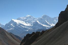
Je trouve toutes sortes d'informations sur la météo à la passe Thorong La. A l'office du tourisme, on nous a dit qu'il n'y a pas de neige, alors qu'un français rencontré hier en revient et nous a dit qu'il a chaussé les crampons.
Quand je regarde les prévisions sur internet, les sites présentent toutes sortes de climats : certains disent que le temps est instable avec vent et précipitations et très froid (-20/25 degrés en ressenti) et d'autres annoncent des températures plus faibles et pas de précipitations. C'est donc difficile de se projeter, car on n'est pas équipé de crampons, et nous ne sommes pas des randonneurs de l'extrême :-).
Savez-vous donc où l'on peut se procurer des informations fiables sur les conditions actuelles et dans un future proche au Thorong La ?
Nous partons d'ici quelques jours, si d'autres ont ce projet on peut partir ensemble :-)
Aussi, nous devrons au moins louer doudoune en plume, pantalon chaud imperméable, bâtons de marche et anorak gore tex sur Pokhara. Connaissez-vous les prix et un magasin qui propose des bonnes offres ?
Merci beaucoup pour vos précieuses infos,
A très bientôt
Sarah
Bonjour Sarah
Déjà ce qui me frappe c'est de prévoir de partir alors que votre ami est malade, même dans quelques jours le trek des Annapurnas ça se prend pas à la légère...le thorong la c'est 5416 m la météo y est très changeante seul des guides expérimentés peuvent vous conseiller...et même avec des guides on se souvient ce qui c'est passé le 14 octobre 2014 il faut rester prudent avec ce col. C'est préférable de le passer avant la fin de matinée car le vent si lève assez vite.
😐
bon chemin
Merci pour votre réponse,
Mon ami a juste une indigestion alors avec quelques jours de repos ça ira. On s'est beaucoup documenté sur le trek et le fameux passage du col, nous n'avons pas de guide mais nous regarderons la météo avant le passage du col. De plus, à cette période, il y a pas mal de touristes avec des guides alors on se greffera a des groupes pour avoir des infos. Et dans le doute, on fera demi-tour. Nous ne prendrons pas de risques inutiles. Merci pour vos conseils. Si vous en avez d'autres n'hésitez pas.
Je souhaite simplement avoir une petite idée sur les températures ces jours-ci.
:-)
A l'office du tourisme, on nous a dit qu'il n'y a pas de neige, alors qu'un français rencontré hier en revient et nous a dit qu'il a chaussé les crampons
Bonjour,
Attention à l'interprétation du mot "neige"...s'agit-il de glace ? De neige de névé (parfois aussi délicate que de la glace) ?
L'utilisation des crampons ne se justifie pas si la neige est "poudreuse".En revanche, un itinéraire peut être totalement dépourvu de neige mais nécessiter les crampons en raison d'un passage délicat (glace ou névé) qui ne peut être franchi si l'on en est pas équipé (et c'est la fin de l'aventure).
Sur un terrain couvert de neige (poudreuse, inconsistante), les crampons s'avèrent inutiles car il se forme sous le crampon un amas de neige (le crampon "botte") qui le rend totalement inefficace voire dangereux et donne une fausse impression de sécurité, les pointes ne mordent plus et les risques de glissade sont accrus.
(Quelques gestes simples comme taper régulièrement ses crampons avec son piolet peut pallier cet inconvénient mais il faut un... piolet. .....et avoir le réflexe de taper ses crampons, ce qui n'est pas inné chez le débutant).
Bonne préparation.
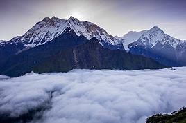
Le temps a ete un peu instable tout le mois de mars. Il y a de la neige a partir de 4000 a 4500 metres. Mais vu la foule sur ce col, il y a une bonne trace.
Bjr, oui c'est bien cela qui m'inquiète : chausser les crampons et se servir du piolet.
Sinon, en ce qui concerne l'altitude, nous avons sommes déjà monté à quasiment cette hauteur en Equateur, bien sur, on n'est jamais à l'abri de mal des montagnes mais bon disons qu'on a déjà eu l'aperçu des contraintes d'une telle altitude, mais y'avait pas de neige ! :-)
Bonsoir Will, merci pour les infos, effectivement n'étant pas adeptes de la randonnée dans la neige avec crampons et piolet, il est plus sage de changer de plan. Surtout si la neige est là à partir de 4000 mètres. Nous pensons du coup faire le sanctuaire des Annapurnas en remontant jusqu'à Muktinath, c'est plus adapté à notre équipement et condition au vu de la météo qui n'est pas très propice à des altitudes plus hautes en ce moment.
Nous sommes toujours à Pokhara, si vous êtes là demain on peut se boire un thé et papoter si vous le souhaitez.
Bonne soirée
Sarah et Andy
Bonjour Sarah723,
Mieux de commencer le trek de Bensishahar/Ngadi/Dharapani pour passer le col de 5416m facilement. Si tu veux partir de Muktinath-col-Manang, tc'est a monter raide. Bonne route,
Aventure
Bonjour Willemspie,
Merci de ton photo.
Il y a eu de la pluie, du vent et de la néige le 28/03/2016 donc le climat ne reste pas le même celui de 17 mars quandmême.
Aventure !!!
Non non on ne passera pas le col du coup on s'arrêtera a Muktinath et on prendra un bus pour redescendre.
Vous connaissez ce site : http://www.viewweather.com/w3822030-weather-forecast-for-thorong_la-western_region.html ?
C'est celui là que je consulte pour avoir un petit état des lieux du col, et bon ça l'air de neiger tous les jours, les températures sont de maximum -11 degrés avec du vent, donc tout de suite la température ressentie doit être beaucoup plus basse, et surtout c'est soit instable ou légèrement instable. Je ne sais pas si ce site est fiable mais les prévisions ne sont pas bonnes pour l'instant même si ça change vite effectivement.
nous étions au Nepal en Jjanvier, nous avons fait seulement le treck des balcons des Annapurnas jusqu'à Goropani et retour par Landruck;
en fait je vous répond pour vous donner l'adresse d'une agence fiable de treck dont les bénéfices vont au profit d'un orphelinat (Main dans la main ) je vous donne donc leur coordonnées . De plus vous pouvez loger chez eux à Pokara (au bord du lac) ils s'occupent de scolariser 10 enfants
ETHICAL trekking Lakeside Pokhara tél : (977)61-464936 9846027997
ethicaltrekkingnepal@yahoo.com
et aussi le no de Krishna le responsable (977) 9856034997 si
i toutefois vous y allez dites que c est de la part de Josy et Gilles
Bon séjour
josy
Savez-vous donc où l'on peut se procurer des informations fiables sur les conditions actuelles et dans un future proche au Thorong La ?
Nous partons d'ici quelques jours, si d'autres ont ce projet on peut partir ensemble :-)
Même si les prévisions que vous pouvez avoir sont tant soit peu fiables elles ne le seront pas sur une semaine!Le temps peut changer très vite sur le Thorong pass et le temps que vous y soyez il peut faire très beau comme très mauvais . Un conseil ne tentez pas le franchissement du col si au lever le ciel n'est pas dégagé. Par contre rarement besoin de crampons et/ou de piolet!
Location de doudounes je ne sais pas mais à l'achat ça tourne autour de 50 euros environ
Tour des Annapurnas mi octobre-novembre 2019 et pas mars comme prévu initialement Grand merci à Djalma et aussi à d’autres personnes intervenues dans la…
Nous revenons d'un trek au Népal et avons rencontré un guide népalais exceptionnel que nous souhaitons faire partager. Remesh et son équipe est très ouvert aux…
Nous aimerions faire un trek au Népal, on pensait au tour de l’Annapurna, moins cher que le trek de l'Everest. Notre idée est de le faire sans guide et sans…
Je prépare le Tour des Annapurnas pour Mars 2027, je recherche une agence locale avec un guide local, si possible francophone pour nous proposer ce trek.…
J'envisage de repartir au Nepal en 2020 pour un second trek (khopra trek fait cette annee). Je pensais m'orienter vers le classique demi tour des Annapurnas…
Bonjour,
Nous souhaitons faire le trek de 4 jours reliant Mestia à Ushguli sans agence. Il est précisé dans les descriptifs qu'il existe des hébergement à chaque étape, mais on ne trouve pas d'info sur ces hébergements. Quelqu'un a-t-il des infos et un avis sur ce parcours?
We're planning to trek in Peru and Bolivia and would love to find some local agencies.
If you know any, could you share details on prices and, of course, the names of the agencies?
Which trek would you recommend?
Elocine
Je pars en autonomie totale sur un trek au Maroc (10jrs) Imilchil - Aghbalou.
Trouve t-on des cartouches gaz à vis (Coleman, Primus) à Marrakech (adresse) ou villages entre Imilchil - Aghbalou ?
Si non , trouve-t-on des cartouches Butagaz pour camping-gaz (petit volume 230 gr ...)
Merci d' avance pour vos réponses
Hello, I’d like to embark on a little trip in my home country, Switzerland. I’ll start walking from La Cure, heading toward Le Noirmont first, then I’ll improvise my route—but it’ll probably follow the French border... at least as far as Lac de Joux.
I’ll decide day by day how much farther to go after that. My goal is to stay in nature as much as possible, wander around for as long as I can, and restock food in villages or towns along the way.
I’m thinking of mostly camping, but we’ll see if I end up in a hotel or another campsite depending on my route.
I’d love to reach La Chaux-de-Fonds on foot... maybe even Delémont.
The whole thing should take about a week, give or take.
I’ll be bringing my dog, and I’m preparing for this as soon as I’m ready.
Any tips to make sure everything goes smoothly for us? Things I should know—or avoid? What about shepherds with their flocks of sheep? And isn’t hunting season open right now?
I’m not sure if what I’m planning is even doable, which is why I’m asking around.
This’ll be my first time doing something like this—wandering in nature *and* with a dog. I’m really excited for this adventure... and I need it. Thanks!
We’re really keen on ecosystems and want to hike in "natural" ancient forests—not planted woods or areas heavily degraded by human activity. Travel guides (like Lonely Planet) don’t provide much info on this. Could you point us to the most interesting spots?
Thanks in advance for your tips.
We wish you happy holidays and a fantastic 2026, full of discoveries!
Claire and Albert
Hi, this might not be the right section, but I’d like to know if it’s possible to start mountaineering with another person without necessarily hiring a guide. We’ve done quite a bit of hiking but not mountaineering—we’ll just do a half-day glacier course. After that, we were thinking of starting with La Grande Motte and the Pointe de la Traversière, which were recommended to us. Honestly, for things like roping up and knots, I’ll learn at home with lots of videos and a book.
Hi,
I don’t know Switzerland at all and was wondering if Vallée des Joux and especially Dent de Vaulion are packed early in the morning or late in the afternoon in July and September?
If so, do you have any quieter spots to recommend in the area, or in Luxembourg (yes, I know it’s not the same country 😉)?
Thanks a lot!
I’m starting this thread—lots of travelers here have done this trek.
When RMS is mentioned, it’s this agency: Ruwenzori Mountaineering Services (with an *s*), because there’s another one online called Ruwenzori Mountaineering Service (no *s*).
Their site:
www.rwenzorimountaineeringservices.com/
From what I gather, it’s the local mountain guide agency certified by the government?
Jaimerais savoir si quelqu'un aurait fait des treks sur le Ruwenzori et combien ça coute en moyenne, les infrastructures, les paysages la sécurité sur les lieux, merci beaucoup. J'attends avec impatience vos réponses.
We’re leaving in 9 days for a two-week trip to Madeira, mainly to hike.
From my research, I’ve found that since last year, access to most trails—and systematically for the most popular ones—is now paid. You have to pay an access fee of 4.50 € per person per classified hike in 2026, and even 10.50 € for the most iconic hike: Pico Arieiro to Pico Ruivo. When paying, you also have to choose a day and a 30-minute time slot for your start time. Of course, this reservation is neither changeable nor refundable, even if the weather that day is terrible.
Personally, given the massive influx of tourists to the island in recent years, I don’t mind paying a fee to help maintain the trails. Similarly, setting a limit on the number of people who can hike them per day is certainly preferable to preserve this priceless heritage.
However, what’s much less fair is that in reality, most of the available spots are reserved: 1/ for Madeira residents (which is normal); 2/ for "economic operators" (meaning local tour operators). For example, if you’re a non-resident (independent tourist), no booking is possible for the Pico Arieiro hike for an early morning start before September! So, unfortunately, we’ll have to skip this hike.
It’s the same issue for Ponta de São Lourenço, the 25 Fontes, Pico Ruivo... in short, all the most popular hikes. Oh well, we’ll skip those too!
So my question is: which hikes do you recommend where we won’t face the huge crowds that the others get? And where we can book the day before for the next day, taking the weather into account?
Finally, a quick accommodation question: we’ve booked the first week in Funchal, but I haven’t decided yet for the second week. Do you have any advice on where to stay in the south or north, preferably avoiding overly concrete-heavy and touristy spots?
I’m reposting about the logistics for Samaria Gorge.
I’d love to get recent info, especially about whether it’s possible to park my car in Omalos, do the hike, and then catch a bus back to my vehicle.
In theory, it’s doable, but when you check the KTEL website, there aren’t any feasible schedules listed. If anyone has recently organized this with reliable, verified details, I’d really appreciate it. Thanks in advance!
Hi there,
We’re flying from Montreal to Lyon this August to go hiking in the French Alps. We’ve rented a car and will be staying at campgrounds. We’re planning to do day hikes and want to stay a few days in one spot, do a few hikes, then move on to our next camping spot. Could you share your favorite spots or any recommendations for places to spend a few days with great hikes?
A few details:
We arrive in early August and leave in early September.
We’re looking for day hikes (or shorter), moderate difficulty, with a cumulative elevation gain of no more than 1000m, and of course, beautiful scenery!
We’d prefer not to drive too much—maybe it’s best not to head too far south and deal with unnecessary heat?
Along the same lines, if you know of any great campgrounds where we can start our hike directly without needing the car, we’d love to hear your suggestions!
Bonjour
Souhaitant faire de la randonnée sur cette île, je voudrais d'abord savoir quelle serait la période la plus favorable sachant que j'avais passé quelques jours en novembre 2018 pas pour cette activité mais plus pour une simple découverte de l'île et le temps n'était pas top notamment en montagne. Donc peut on choisir une organisation en étoile sachant que je louerai un véhicule avec éventuellement 2 points d'hébergement.
Je n'envisage pas d'intégrer une structure mais de partir à 2 et de s'organiser sauf si vous me conseillez une agence locale ou un guide local. Enfin même si je compte me procurer les différents supports, carte et topo guide plus gps je vous remercie de bien vouloir me communiquer les randos à faire en priorité
Merci beaucoup pour vos informations
I’m planning to do the Mercantour crossing following the Randoxygène route in mid-July.
I’m used to hiking in the mountains, but I sometimes get vertigo, for example on ridges with drops on both sides. I wanted to check if there are any T4 or T3-T4 sections and find out if there are any very exposed passages—and if so, where—so I can plan an alternative route.
Can anyone give me some info on this?
Thanks!
I’m planning a trip around Cap Corse and the AGRIATES in 2026, from May 8th to 15th (there are still 2 spots left, by the way! Just DM me if you're interested).
I’d love to know which hikes are worth prioritizing in the AGRIATES. We’ll be staying in SALECCIA for two days as our base—what should we focus on from there?
A round trip to IGNHU beach? Any other suggestions?
For Ostricano, I think it’s too far for a round trip...
Thanks for your tips!
Have a great day,
Anie, Toulouse
I’d like to get some info about the GR10 Pyrenees traverse. I need help planning the daily stages and accommodations—my wife isn’t an experienced hiker but walks a lot, so I’d like to schedule shorter walking days and thus a longer overall trip in terms of number of days.
Could anyone give me some help and advice?
Best regards,
New to this forum, I’m planning a pretty big project for 2028.
I’m heading to Nepal to do a trek from Kathmandu all the way to Everest Base Camp (a cool 5,300 m 😄).
This trek is a bit special because even though I’ll be part of a group, I’m going solo (so far, no problem—I’m used to it). But it’s my first real trek, and it’s also a humanitarian one: once I reach base camp, I’ll stay an extra week to help clean up the waste left by tens of thousands of climbers! Since I’m originally from South America, from two countries that share the Andes, I have a deep respect for mountains—they fascinate me. So Everest… it’s kind of the trip of a lifetime!
So, a little question for those who’ve done treks to Everest before… any tips for good mental preparation (I’m already working on the physical side)?
Hi there, I’m planning the Annapurna Circuit for March 2027 and I’m looking for a local agency with a local guide—preferably French-speaking—to arrange this trek for us. Any suggestions? Thanks
Hello!
We’re spending a few days in Toraja country at the end of May. We’d love to do a day trek—taking our time—on a route that’s stunning in terms of scenery, but not a level 5 in difficulty!
Any suggestions you can share, please?
Thanks in advance
I’d like to do the Mare a Mare Sud in May over 4 days. I’ve found quite a few places to stay along the route, but I’m stuck on the start and finish.
I’ll be arriving by plane on Sunday evening and would like to start pretty early on Monday morning. Ideally, accommodation right at the trailhead (Alzu di Gallina) would be amazing, but I can’t find anything. Any tips?
Also, for the transfer from Figari Airport to Porto Vecchio or Alzu di Gallina?
At the end, I’d like to pick up a rental car—any advice on that too?
I’m traveling solo by plane to Catania in May and plan to hike the northern side of Etna, starting from Linguaglossa where I’ll arrive by bus. After that, I’d love some info on how to get up to Piano Provenzana (shuttles or hitchhiking), since it seems there’s no public transport except in the summer. Can you sleep there in a free or cheap refuge, or camp? And how far up can you go without having to hire a guide? Thanks in advance. Bernard.
Bonjour a tous,
je pars en voyage au Maroc en aout et nous allons commencer par nous arrêter a Chefchaouen(nous sommes en voiture).
Ma question: quelqu'un peut il m'indiquer un itinéraire de rando en boucle d'entre 5 et 7 jours aux départ de Chefchaouen dans le parc de Talassemtane passant si possible par le pont de dieux?Ou un guide papier qui en reunis quelques uns?
Nous privilégions le camping sauvage et les gites.
Merci d'avance
Hi there, for those who’ve been recently—is it possible to find other solo travelers in March on the island to share transport or room costs? It doesn’t seem easy to travel on a budget.
If you have any recommendations for simple lodgings or places with dorms, I’d love to hear them.
For those who’ve done multi-day treks while moving around: do you need to bring your own sleeping bag? I’d love to hear about itineraries you’ve done without a guide, just with a map and GPS.
Thanks, and have a great day!
Hi everyone!
We’re planning a 15-day road trip to Scotland this summer, specifically to explore and hike on Lewis and Harris—places we’ve never been before. We’ve visited other islands on previous road trips in Scotland (we usually go in April for a week). This would be our first time in Scotland in the summer and for 15 days. We’re looking at late August to early September.
I’m currently drafting the itinerary. We’d be crossing from Ullapool and were thinking of spending 3 nights on Harris and 4 nights on Lewis.
Does that sound balanced to you? Is it better to keep the same accommodation on Harris and the same on Lewis to explore the area? I’d love to hear about any past experiences you’ve had on these islands.
Thanks!
Hi there, I’m trying to leave for 15 days very soon to São Vicente. I’m either looking to join an agency or figure things out on my own to go hiking on one of these islands or both. From what I’ve seen, it’s not easy to organize with local transport, so it gets expensive. Can I use the services of a small local agency? I’m looking for the simplest way to hike for several days. Also, how do you get from São Vicente to São Nicolau? Thanks in advance and have a great day!
Aichatou
I’ve been wanting to do this for several years, and this year’s the one. Next September, I’ll be trekking in Tusheti (Georgia), from Omalo to Shatili.
Of course, I won’t be renting a vehicle that’d just sit unused. No problem getting to Pshaveli, but from there to Omalo, it’s a dirt road (still the case?)
There must be some form of public transport since there are so many guesthouses, and not all travelers come in a 4x4.
If any of you have been to Omalo, could you confirm that these shared transports exist and how often they run?
we’re planning a trip to Yellowstone and hoping to do a three-day backcountry hike if we get a permit.
if any of you have done this before, could you let me know if it’s possible to find water along the way? And if we can transport it, are we allowed to use a stove?