Bonjour à tous
Quelqu’un a-t-il des informations quand aux conditions de marche sur le trek du tour du Manaslu.
Apparemment, début mars des groupes ont fait demi tour à cause de la neige.
Nous sommes sensés y passer dans 3 semaine!
Merci
De toutes façons, un passage à plus de 5.000, même à cette latitude, est toujours un peu aléatoire : la moindre perturbation donne de la neige au col et le passage, bien qu'assez fréquenté désormais, peut être bouché plusieurs jours ... Lorsque nous l'avons passé, à la "bonne saison" (automne, après la mousson), le col était resté impraticable plusieurs jours et certains trekkeurs avaient dû rebrousser chemin !!! deux jours plus tard, c'était sans problème, malgré une descente avec des épisodes sur neige tassée (on peut prévoir des mini crampons de balade) ... Donc, qqs soit la période envisagée, il faut intégrer "mentalement" la possibilité que le col soit fermé (et ne pas essayer de passer coûte que coûte ... une "crachée" de neige, ça peut faire 50/70 cm en rien de temps et vous mettre en danger )
Confiance, cependant, dès que les conditions redeviennent correctes, les gens font au plus vite !!
bonjour,
100% d'accord avec la réponse précédente.
C'est pour cela qu'il est plus simple d'être en "autonomie" via à vis d'un groupe et d'attendre le "beau temps pour le passage et donc de se préparer à avoir un peu de marge entre les temps de treck et les temps de présence au Népal.
Dominique
PS : et puis que dire de passer un col à plus de 5000m dans le brouillard et la neige ! c'est à ces altitudes que parfois (et c'est le cas du Larkya la)
D'accord avec les réponses ci-dessus. Demander les conditions 3 semaines avant le passage d'un col au dessus de 4500m au Népal... autant demander à Madame Irma ;)
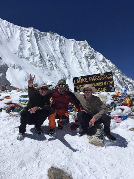
Hier, encore bonnes chutes de neige dans ce secteur. Je connais un groupe qui redescend et a renoncé à passer le Larke La, malgré un guide très expérimenté.
Ce matin, des personnes ont passé le Thorong La sur le tour des Annapurnas, mais c'était chaud (enfin plutôt très froid).
Aujourd'hui, grand soleil sur le Népal. Donc je pense que d'ici 2-3 jours, pas de souci... si ça se maintient... Mais pour ça faut demander à Irma ! Y a plus de saison :(
Veuillez m'excusez, je vous écris pour avoir des infos et non pour vous en donnez.
je suis en préparation pour mars 2020 de faire également le tour du manaslu en solitaire.
J'aurais besoin à votre retour de beaucoup d'infos sur votre trek.
Est-ce que vous pouvez me contacter à votre retour ?
Entre février et avril 2019, il y a eu des chutes de neige record au Népal, du jamais vu. Impossible de savoir si c'est un évènement isolé ou le début d'une tendance.
Bonjour,
J'ai passé le col le 16 Avril sous un soleil éblouissant et pas de glace à la descente.
Le lendemain, le franchissement n'était pas possible à cause du mauvais temps.
Il faut vraiment suivre les conseils du guide qui consulte la météo et ses collègues.
J'ai aussi croisé plusieurs personnes qui avaient fait 1/2 tour à cause des conditions météo.
Donc d'un jour sur l'autre , tout peut changer.
Joëlle
Bonjour, nous comptons faire le tour du Manaslu fin avril 2020. Nous avons contacter des agences. Pourriez vous me dire si vous avez commencé le trek à Barpak/lapak pour éviter la piste ou bien en 4x4 à partir d'Arughat vers soti Kholoa et commencer le trek à Soti khola.
Pourriez vous me dire si ce trek est difficile et si ca vaut le coup! J'ai fait le mustang.
merci
Bonsoir
Nous sommes partis de Barpak.
Effectivement cela permet d’éviter le fond de vallée mais il en reste ensuite.
Par contre le premier jour c’est 1700 m de D+.
Si vous n’arrivez pas trop tard à Barpak ni trop cassés par la route (c’est long) montez le soir à Laprak ce sera toujours ça de fait. Et le spectacle doit être sympa (nous étions dans le brouillard). Les lodges ont l’air très sympathiques.
Si vous souhaitez connaître l’agence avec laquelle nous sommes partis faites moi le savoir. Ils nous ont proposé quelques très bon moments et sont très sérieux.
A+
Non le bus s’arrête à Barpak.
Trop fatigués pour partir à 17h00 pour 3 h de marché après une dizaine d’heures de tape c...(bus).
Je n’ai pas trouvé ce trek plus difficile que le tour des Annapurna la première partie est un peu longue dans la vallée mais cependant variée.
Le passage du col est juste magnifique
L’agence s’appelle Azimut Népal
On peut aller maintenant en bus à Barpak?!! Encore un an ou 2 et on pourra faire le tour du Manaslu en bus!
Lors de mon trek plus aucune route ni piste après Gurkha... Une piste défoncée pour Arughat Bazar rien ensuite.
Lors de mon trek plus aucune route ni piste après Gurkha... Une piste défoncée pour Arughat Bazar rien ensuite.
Si cela peut te consoler, début novembre 2017, cette piste était toujours aussi défoncée. La pire de tous mes voyages, ayant supplantée une route du Madhya Pradesh (Inde) qui s'apparentait en 2012 à de la tôle ondulée. Pas étonnant que cette route Gorkha - Arughat ait servi de cadre à un épisode de la série documentaire "Les routes de l'impossible".
Côté tibétain, une route arrivait déjà en novembre 2017 au Rui La, col frontière au nord de Samdo via le lieu-dit Larkya Bazar.
Fabrice
S'exposer à l'Etranger lointain amène à mieux connaître et comprendre sa propre Culture.
Pas étonnant que cette route Gorkha - Arughat ait servi de cadre à un épisode de la série documentaire "Les routes de l'impossible".
Je ne parlais pas de la piste Gorkha Arughat car j'ignorais son existence.
J'ai parcouru le tour du Manaslu en 1985 à partir d'Arughat en suivant les gorges de la Bhudi Gandaki et la piste qui y accédait venait de quelque part à partir de la route principale qui va de Katmandou jusqu'à Pokhara.
En 2012 ou 2013 je suis allé dans la vallée de la Tsum puis dans le Ganesh Himal et cette fois en partant de Gorkha : Gokrha/ Mandre /Barpak/Laprak...
j'ai fait le mustang il y 2 ans ! Le sentier de trek c'est la route en construction, les paysages et les villages étaient extraordinaires mais pas le sentier quel dommage. J'espère que le tour de Manaslu sera différent qu'on évitera la route.
j'ai fait le mustang il y 2 ans ! Le sentier de trek c'est la route en construction, les paysages et les villages étaient extraordinaires mais pas le sentier quel dommage. J'espère que le tour de Manaslu sera différent qu'on évitera la route.
De ce que j'ai lu sur d'autres forums, la route arrive désormais un peu en amont de Tatopani, en rive droite en face de Dhoban (le sentier y reste préservé en rive gauche). Cela correspond à ce qui avait été notre première journée début novembre 2017 : Liding -> Thulo Dunga. Partis aux aurores, nous avions franchi la zone en travaux (falaise avant Khorlabesi à l'époque) avant même que les ouvriers soient à l'oeuvre.
Côté vallée de la Dudh Khola (après le Larkya La), il y avait en novembre 2017 une piste un peu en amont de Tilje / Tiliche. Sans le moindre trafic routier car cette portion de route n'est pas reliée à Dharapani.
Fabrice
S'exposer à l'Etranger lointain amène à mieux connaître et comprendre sa propre Culture.
j'ai fait le mustang il y 2 ans ! Le sentier de trek c'est la route en construction,
Ton agence ne s'est pas trop foulée...Il existe des sentiers alternatifs pour éviter cette piste jusqu'à Lo Mantang.D'autre part en cap retour il existe d'autres possibilités pour rentrer de trek par Muktinath et d'autres itinéraires plus engagés cette fois par le Saribung ( vers Nar/phu)
Ps: je parlais du haut Mustang ( au nord de Kagbeni) car il semblerait qu'il s'agisse pour toi du "lower" Mustang avec également ses chemins alternatifs .
je suis d'accord avec toi, l'agence ne devait pas connaître le mustang et jusqu'à Lo Mantang on a quasiment suivi la piste ! Le trek était bien mais saurait pu être mieux ! Pour le Manaslu apparemment c'est pareil, je voulais savoir jusqu'où allait la route.
je suis d'accord avec toi, l'agence ne devait pas connaître le mustang et jusqu'à Lo Mantang
C'est certain car mon trek au Mustang ne date que de quelques années ; la piste était pourtant déjà construite et on n'a fait que la couper à 2 ou 3 reprises sans jamais la suivre à part quelques Kms avant d'arriver à Lo Mantang Par contre on rencontré à chaque étape ou presque une personne avec un peu d'embonpoint qui a fait (avec sa fille) le trajet à cheval et ils ont de ce fait emprunté la piste presque tout le temps.
Partis également de Barpak, et je confirme: le bus monte là avec difficulté, mais monte.
Le trek a duré 12 jours avec Azimut Népal également; il n'est pas difficile; il suffit de pouvoir durer..et que les conditions météo soient favorables pour passer le col.
Le guide se renseigne pour que nous passions dans des conditions optimales.
Ceci dit, cette agence prête des crampons au cas où.
Je repars le 28 faire le Kanchenjunga avec cette même agence; c'est dire sans hésitation que Christophe gère avec compétence et sérieux.
Bonne soirée,
Joëlle
Bonjour, nous comptons faire le tour du Manaslu fin avril 2020. Nous avons contacter des agences. Pourriez vous me dire si vous avez commencé le trek à Barpak/lapak pour éviter la piste ou bien en 4x4 à partir d'Arughat vers soti Kholoa et commencer le trek à Soti khola.
Pourriez vous me dire si ce trek est difficile et si ca vaut le coup! J'ai fait le mustang.
merci
Bonjour,
J'ai changé d'avis je vais faire ton compte fais le Grand-tour des Annapurnas via le lac-Tilicho et le col du Thorong-La.
Je pense le faire en 18 jours. J'arrive à Katmandou le 02 avril et je repart le 23 avril 2020.
Grand-tour des Annapurnas via le lac-Tilicho et le col du Thorong-La.
A noter qu'il n'est pas nécessaire de repasser par Manang. Depuis Shree Kharka, il est possible de rejoindre le village abandonné de Upper Khangsar, puis de poursuivre vers Yak Kharka où l'on rejoint le sentier Manang - Thorung Phedi.
Si l'on a dormi à Shree Kharka ou à Tilicho Base Camp, plus besoin d'acclimatation intermédiaire avant Thorung Phedi. Il est alors possible de faire en une longue journée Tilicho Base Camp -> Thorung Phedi. C'est en tout cas ce que j'ai fait à 56 ans, sans être sportif, sans portage.
Fabrice
S'exposer à l'Etranger lointain amène à mieux connaître et comprendre sa propre Culture.
Bonjour Thierry,
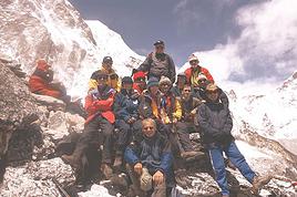
Oui, revenue depuis deux jours et enchantée par ce trek avec 20 jours de marche et col à 5300 m, sans difficulté si ce 'est les éboulis importants pour se rendre au camp de base nord et 10 jours au-dessus de 3000 m.
Paysages très variés: haute montagne, forêts enchantées, nombreuses fleurs, villages et lodges accueillants.
De quoi te donner envie, j'espère.
Bonne journée,
Joëlle
Très beau temps pendant tout le trek, beaucoup de fleurs (pas les rhodos), températures douces avec le soleil.
Après, il fait un peu plus froid...Car 10 jours au-dessus de 3000 m.
Joêlle
Je pense repartir au Népal pour la troisième fois. J’ai déjà fait le tour des Annapurna et la haute route dans le Khumbu. Cette fois ci je pense faire le Tour…
Bonour à tous, je viens de m'inscrire sur un trek avec glacier safari trek, il s'agit du tour du Manaslu, à 2 candidats le trek est validé. le 8 octobre 2018,…
Je recherche un guide de confiance pour faire un trek au Népal fin décembre début janvier. Manaslu ou Langtang-Helambu-Gos... Pourriez vous me communiquer des…
Le projet de faire le trek de Manaslu Arughat - Dharapani (via Tsum Valley "Mu Gompa") en mode lodge à la cool avec des jours d'acclimatations (excursion…
Je devais partir avec un groupe d'amis pour faire le tour du Manaslu et la vallée de tsum le mois prochain, mais les aléas de vie ont décimé mon groupe si bien…
Bonjour,
Nous souhaitons faire le trek de 4 jours reliant Mestia à Ushguli sans agence. Il est précisé dans les descriptifs qu'il existe des hébergement à chaque étape, mais on ne trouve pas d'info sur ces hébergements. Quelqu'un a-t-il des infos et un avis sur ce parcours?
We're planning to trek in Peru and Bolivia and would love to find some local agencies.
If you know any, could you share details on prices and, of course, the names of the agencies?
Which trek would you recommend?
Elocine
Je pars en autonomie totale sur un trek au Maroc (10jrs) Imilchil - Aghbalou.
Trouve t-on des cartouches gaz à vis (Coleman, Primus) à Marrakech (adresse) ou villages entre Imilchil - Aghbalou ?
Si non , trouve-t-on des cartouches Butagaz pour camping-gaz (petit volume 230 gr ...)
Merci d' avance pour vos réponses
Hello, I’d like to embark on a little trip in my home country, Switzerland. I’ll start walking from La Cure, heading toward Le Noirmont first, then I’ll improvise my route—but it’ll probably follow the French border... at least as far as Lac de Joux.
I’ll decide day by day how much farther to go after that. My goal is to stay in nature as much as possible, wander around for as long as I can, and restock food in villages or towns along the way.
I’m thinking of mostly camping, but we’ll see if I end up in a hotel or another campsite depending on my route.
I’d love to reach La Chaux-de-Fonds on foot... maybe even Delémont.
The whole thing should take about a week, give or take.
I’ll be bringing my dog, and I’m preparing for this as soon as I’m ready.
Any tips to make sure everything goes smoothly for us? Things I should know—or avoid? What about shepherds with their flocks of sheep? And isn’t hunting season open right now?
I’m not sure if what I’m planning is even doable, which is why I’m asking around.
This’ll be my first time doing something like this—wandering in nature *and* with a dog. I’m really excited for this adventure... and I need it. Thanks!
We’re really keen on ecosystems and want to hike in "natural" ancient forests—not planted woods or areas heavily degraded by human activity. Travel guides (like Lonely Planet) don’t provide much info on this. Could you point us to the most interesting spots?
Thanks in advance for your tips.
We wish you happy holidays and a fantastic 2026, full of discoveries!
Claire and Albert
Hi, this might not be the right section, but I’d like to know if it’s possible to start mountaineering with another person without necessarily hiring a guide. We’ve done quite a bit of hiking but not mountaineering—we’ll just do a half-day glacier course. After that, we were thinking of starting with La Grande Motte and the Pointe de la Traversière, which were recommended to us. Honestly, for things like roping up and knots, I’ll learn at home with lots of videos and a book.
Hi,
I don’t know Switzerland at all and was wondering if Vallée des Joux and especially Dent de Vaulion are packed early in the morning or late in the afternoon in July and September?
If so, do you have any quieter spots to recommend in the area, or in Luxembourg (yes, I know it’s not the same country 😉)?
Thanks a lot!
Jaimerais savoir si quelqu'un aurait fait des treks sur le Ruwenzori et combien ça coute en moyenne, les infrastructures, les paysages la sécurité sur les lieux, merci beaucoup. J'attends avec impatience vos réponses.
We’re leaving in 9 days for a two-week trip to Madeira, mainly to hike.
From my research, I’ve found that since last year, access to most trails—and systematically for the most popular ones—is now paid. You have to pay an access fee of 4.50 € per person per classified hike in 2026, and even 10.50 € for the most iconic hike: Pico Arieiro to Pico Ruivo. When paying, you also have to choose a day and a 30-minute time slot for your start time. Of course, this reservation is neither changeable nor refundable, even if the weather that day is terrible.
Personally, given the massive influx of tourists to the island in recent years, I don’t mind paying a fee to help maintain the trails. Similarly, setting a limit on the number of people who can hike them per day is certainly preferable to preserve this priceless heritage.
However, what’s much less fair is that in reality, most of the available spots are reserved: 1/ for Madeira residents (which is normal); 2/ for "economic operators" (meaning local tour operators). For example, if you’re a non-resident (independent tourist), no booking is possible for the Pico Arieiro hike for an early morning start before September! So, unfortunately, we’ll have to skip this hike.
It’s the same issue for Ponta de São Lourenço, the 25 Fontes, Pico Ruivo... in short, all the most popular hikes. Oh well, we’ll skip those too!
So my question is: which hikes do you recommend where we won’t face the huge crowds that the others get? And where we can book the day before for the next day, taking the weather into account?
Finally, a quick accommodation question: we’ve booked the first week in Funchal, but I haven’t decided yet for the second week. Do you have any advice on where to stay in the south or north, preferably avoiding overly concrete-heavy and touristy spots?
I’m reposting about the logistics for Samaria Gorge.
I’d love to get recent info, especially about whether it’s possible to park my car in Omalos, do the hike, and then catch a bus back to my vehicle.
In theory, it’s doable, but when you check the KTEL website, there aren’t any feasible schedules listed. If anyone has recently organized this with reliable, verified details, I’d really appreciate it. Thanks in advance!
Hi there,
We’re flying from Montreal to Lyon this August to go hiking in the French Alps. We’ve rented a car and will be staying at campgrounds. We’re planning to do day hikes and want to stay a few days in one spot, do a few hikes, then move on to our next camping spot. Could you share your favorite spots or any recommendations for places to spend a few days with great hikes?
A few details:
We arrive in early August and leave in early September.
We’re looking for day hikes (or shorter), moderate difficulty, with a cumulative elevation gain of no more than 1000m, and of course, beautiful scenery!
We’d prefer not to drive too much—maybe it’s best not to head too far south and deal with unnecessary heat?
Along the same lines, if you know of any great campgrounds where we can start our hike directly without needing the car, we’d love to hear your suggestions!
Bonjour
Souhaitant faire de la randonnée sur cette île, je voudrais d'abord savoir quelle serait la période la plus favorable sachant que j'avais passé quelques jours en novembre 2018 pas pour cette activité mais plus pour une simple découverte de l'île et le temps n'était pas top notamment en montagne. Donc peut on choisir une organisation en étoile sachant que je louerai un véhicule avec éventuellement 2 points d'hébergement.
Je n'envisage pas d'intégrer une structure mais de partir à 2 et de s'organiser sauf si vous me conseillez une agence locale ou un guide local. Enfin même si je compte me procurer les différents supports, carte et topo guide plus gps je vous remercie de bien vouloir me communiquer les randos à faire en priorité
Merci beaucoup pour vos informations
I’m planning to do the Mercantour crossing following the Randoxygène route in mid-July.
I’m used to hiking in the mountains, but I sometimes get vertigo, for example on ridges with drops on both sides. I wanted to check if there are any T4 or T3-T4 sections and find out if there are any very exposed passages—and if so, where—so I can plan an alternative route.
Can anyone give me some info on this?
Thanks!
I’m planning a trip around Cap Corse and the AGRIATES in 2026, from May 8th to 15th (there are still 2 spots left, by the way! Just DM me if you're interested).
I’d love to know which hikes are worth prioritizing in the AGRIATES. We’ll be staying in SALECCIA for two days as our base—what should we focus on from there?
A round trip to IGNHU beach? Any other suggestions?
For Ostricano, I think it’s too far for a round trip...
Thanks for your tips!
Have a great day,
Anie, Toulouse
I’d like to get some info about the GR10 Pyrenees traverse. I need help planning the daily stages and accommodations—my wife isn’t an experienced hiker but walks a lot, so I’d like to schedule shorter walking days and thus a longer overall trip in terms of number of days.
Could anyone give me some help and advice?
Best regards,
New to this forum, I’m planning a pretty big project for 2028.
I’m heading to Nepal to do a trek from Kathmandu all the way to Everest Base Camp (a cool 5,300 m 😄).
This trek is a bit special because even though I’ll be part of a group, I’m going solo (so far, no problem—I’m used to it). But it’s my first real trek, and it’s also a humanitarian one: once I reach base camp, I’ll stay an extra week to help clean up the waste left by tens of thousands of climbers! Since I’m originally from South America, from two countries that share the Andes, I have a deep respect for mountains—they fascinate me. So Everest… it’s kind of the trip of a lifetime!
So, a little question for those who’ve done treks to Everest before… any tips for good mental preparation (I’m already working on the physical side)?
Hi there, I’m planning the Annapurna Circuit for March 2027 and I’m looking for a local agency with a local guide—preferably French-speaking—to arrange this trek for us. Any suggestions? Thanks
Hello!
We’re spending a few days in Toraja country at the end of May. We’d love to do a day trek—taking our time—on a route that’s stunning in terms of scenery, but not a level 5 in difficulty!
Any suggestions you can share, please?
Thanks in advance
I’d like to do the Mare a Mare Sud in May over 4 days. I’ve found quite a few places to stay along the route, but I’m stuck on the start and finish.
I’ll be arriving by plane on Sunday evening and would like to start pretty early on Monday morning. Ideally, accommodation right at the trailhead (Alzu di Gallina) would be amazing, but I can’t find anything. Any tips?
Also, for the transfer from Figari Airport to Porto Vecchio or Alzu di Gallina?
At the end, I’d like to pick up a rental car—any advice on that too?
I’m traveling solo by plane to Catania in May and plan to hike the northern side of Etna, starting from Linguaglossa where I’ll arrive by bus. After that, I’d love some info on how to get up to Piano Provenzana (shuttles or hitchhiking), since it seems there’s no public transport except in the summer. Can you sleep there in a free or cheap refuge, or camp? And how far up can you go without having to hire a guide? Thanks in advance. Bernard.
Bonjour a tous,
je pars en voyage au Maroc en aout et nous allons commencer par nous arrêter a Chefchaouen(nous sommes en voiture).
Ma question: quelqu'un peut il m'indiquer un itinéraire de rando en boucle d'entre 5 et 7 jours aux départ de Chefchaouen dans le parc de Talassemtane passant si possible par le pont de dieux?Ou un guide papier qui en reunis quelques uns?
Nous privilégions le camping sauvage et les gites.
Merci d'avance
Hi there, for those who’ve been recently—is it possible to find other solo travelers in March on the island to share transport or room costs? It doesn’t seem easy to travel on a budget.
If you have any recommendations for simple lodgings or places with dorms, I’d love to hear them.
For those who’ve done multi-day treks while moving around: do you need to bring your own sleeping bag? I’d love to hear about itineraries you’ve done without a guide, just with a map and GPS.
Thanks, and have a great day!
Hi everyone!
We’re planning a 15-day road trip to Scotland this summer, specifically to explore and hike on Lewis and Harris—places we’ve never been before. We’ve visited other islands on previous road trips in Scotland (we usually go in April for a week). This would be our first time in Scotland in the summer and for 15 days. We’re looking at late August to early September.
I’m currently drafting the itinerary. We’d be crossing from Ullapool and were thinking of spending 3 nights on Harris and 4 nights on Lewis.
Does that sound balanced to you? Is it better to keep the same accommodation on Harris and the same on Lewis to explore the area? I’d love to hear about any past experiences you’ve had on these islands.
Thanks!
Hi there, I’m trying to leave for 15 days very soon to São Vicente. I’m either looking to join an agency or figure things out on my own to go hiking on one of these islands or both. From what I’ve seen, it’s not easy to organize with local transport, so it gets expensive. Can I use the services of a small local agency? I’m looking for the simplest way to hike for several days. Also, how do you get from São Vicente to São Nicolau? Thanks in advance and have a great day!
Aichatou
I’ve been wanting to do this for several years, and this year’s the one. Next September, I’ll be trekking in Tusheti (Georgia), from Omalo to Shatili.
Of course, I won’t be renting a vehicle that’d just sit unused. No problem getting to Pshaveli, but from there to Omalo, it’s a dirt road (still the case?)
There must be some form of public transport since there are so many guesthouses, and not all travelers come in a 4x4.
If any of you have been to Omalo, could you confirm that these shared transports exist and how often they run?
we’re planning a trip to Yellowstone and hoping to do a three-day backcountry hike if we get a permit.
if any of you have done this before, could you let me know if it’s possible to find water along the way? And if we can transport it, are we allowed to use a stove?
Hello,
I’ll be in Nepal from March 6th to 29th (we’re flying into Kathmandu via Varanasi and leaving via Delhi).
I’m a bit confused about the regulations requiring a guide.
My wife and I (we’re 63 and 64) aren’t experienced trekkers—we’re more used to walking on terrain with very moderate elevation changes. I’m looking for fairly easy hikes, possibly day trips.
Here are my questions:
- Does the Poon Hill trek from Pokhara require a guide, or is it better to go through a local agency? (I’ve seen a lot of them offering 4-day packages)
- I’d like to do a few multi-day hikes around Jomsom (Kagbeni, Mukitinath, Lupra, Marpha)... Do you need a guide for those, and can you find accommodations easily without booking in advance?
Last question—I’m really hesitant to lug around a sleeping bag or down jacket during our 6 weeks in India. Can you easily find these kinds of items at reasonable prices in Pokhara?
Thanks in advance for any tips you can share!
Yann