Results for "parapente+|+46+>+91"
1947 results found.
Topo guide de randonnée aux Canaries English translation pending
Je compte faire un séjour de 2 semaines sur les différentes îles des Canaries et je cherche à savoir s'il est possible de se procurer ici en France ou sur place des topo guide pour nous guider et rester autonome.
Merci.
Sécurité sociale et assedics à la Réunion? English translation pending
hello, voila ma seule question : je pars a la réunion pour 4 mois qui vont très surement se prolonger en années, alors à ceux qui y sont partis : c tout pareil qu'en france la sécu ? j'ai juste à m'inscrire dnas une agence; ou ça change ??? idem pour les assedics et tout le tralala.....c le baza ces trucs administratifs !
Manali et la vallée de Kulu (Inde) English translation pending
slt a vous intrepides voyageurs et autres jedi!est ce qu'il s'en trouverai parmi vous qques uns ou unes qui pourrai me refiler des infos sur manali et la vallée de kulu !?! ambiance generale, paysages, climat, ???etc etc ...merci et bon voyage a tous!!
Louer un petit avion en Inde? English translation pending
Est-ce possible de louer un petit avion à petit prix en inde? Par exemple Cessna 172
Voyage dans le cockpit English translation pending
Bonjour, avez vous eu l'occasion de voyager dans le cockpit, d'assister à un décollage ou à un atterrissage en étant assis près des pilotes? j'ai eu cette chance une fois en A 320 et j'en garde un souvenir extra.
Certains parmi vous sont-ils ou auraient-ils aimé etre pilote, hotesse ou steward?
Certains parmi vous sont-ils ou auraient-ils aimé etre pilote, hotesse ou steward?
Baie d'Olu Deniz et Hôtel Oludeniz Resort English translation pending
Salut à tous,
j'envisage de partir fin octobre en Turquie avec mon mari et mes deux enfants et j'ai vu que la baie d'Oludeniz est l'une des plus belles baies avec eau turquoise...
Est-ce quelqu'un connait l'hotel Oludeniz resort ou a des infos sur cette fameuse baie.
C'est à 12 km de la ville de Fethyie. Est-ce qu'il y a des belles choses à voir..
Merci d'avance.
Loulou
j'envisage de partir fin octobre en Turquie avec mon mari et mes deux enfants et j'ai vu que la baie d'Oludeniz est l'une des plus belles baies avec eau turquoise...
Est-ce quelqu'un connait l'hotel Oludeniz resort ou a des infos sur cette fameuse baie.
C'est à 12 km de la ville de Fethyie. Est-ce qu'il y a des belles choses à voir..
Merci d'avance.
Loulou
transport du matériel photo/video.... English translation pending
Bonjour,
nous partons très bientôt avec nos 2 enfants pour un voyage de presque 2 mois en malaisie/bornéo
d'habitude nous partons avec un appareil numérique(le coolpix 5700 Nikon)assez compact donc pas de soucis
mais pour ce voyage nous venons d'acquérir le reflex numérique Nikon D70, donc un autre format + les Zooms + un caméscope (hc42 Sony)assez petit mais qui prend qd même de la place, le tout devient assez conséquent
je ne sais pas comment vous faites, mais nous en général on se trimballe ça partout avec nous(impossible de laisser ça dans une chambre d'hôtel)
comment procédez vous pour les déplacements(j'entends par là, une fois les gros sacs à dos dans la chambre d'hôtel) sac à dos spéciaux pour appareil photo, ou alors tout en vrac dans un petit sac à dos ??!?
sachant qu'en + de tout ça nous avons aussi les truc basics, le guide, la bouteille d'eau, l'anti moustique.... enfin tout le bazar (nous avons un petit de 5 ans)
je sais c'est très pratique comme question, mais nous n'avons pas envie de nous charger comme des ânes
nous partons très bientôt avec nos 2 enfants pour un voyage de presque 2 mois en malaisie/bornéo
d'habitude nous partons avec un appareil numérique(le coolpix 5700 Nikon)assez compact donc pas de soucis
mais pour ce voyage nous venons d'acquérir le reflex numérique Nikon D70, donc un autre format + les Zooms + un caméscope (hc42 Sony)assez petit mais qui prend qd même de la place, le tout devient assez conséquent
je ne sais pas comment vous faites, mais nous en général on se trimballe ça partout avec nous(impossible de laisser ça dans une chambre d'hôtel)
comment procédez vous pour les déplacements(j'entends par là, une fois les gros sacs à dos dans la chambre d'hôtel) sac à dos spéciaux pour appareil photo, ou alors tout en vrac dans un petit sac à dos ??!?
sachant qu'en + de tout ça nous avons aussi les truc basics, le guide, la bouteille d'eau, l'anti moustique.... enfin tout le bazar (nous avons un petit de 5 ans)
je sais c'est très pratique comme question, mais nous n'avons pas envie de nous charger comme des ânes
Climat au Maroc en mars? English translation pending
Bonjours a tous
Je pars pour le maroc du 13 mars au 22 mars, 😎😎😎 mais je ne connais pas du tout cette region et vu que j y serais pas tres longtemps j aimerais avoir qque conseils d itineraires possibles et interessant. En gros j arrive le midi a marrakech donc j ai le temps de trouver un hotel, auberge ou autre...
D ailleurs si vous avez des conseils? De rester une journé et demi sur marrakech et apres de bouger pendant 5-6 jours avant de prendre du bon temps a marrakech pendant 2 jours et d acheter des ptites choses. Donc je suis preneur de tout anecdotes, bons plans, suggestions d itineraires....budget, temps de transport(bus, train?)??? 🤪 Et au fait question temps, le Maroc ca donne quoi?
Merci
Je pars pour le maroc du 13 mars au 22 mars, 😎😎😎 mais je ne connais pas du tout cette region et vu que j y serais pas tres longtemps j aimerais avoir qque conseils d itineraires possibles et interessant. En gros j arrive le midi a marrakech donc j ai le temps de trouver un hotel, auberge ou autre...
D ailleurs si vous avez des conseils? De rester une journé et demi sur marrakech et apres de bouger pendant 5-6 jours avant de prendre du bon temps a marrakech pendant 2 jours et d acheter des ptites choses. Donc je suis preneur de tout anecdotes, bons plans, suggestions d itineraires....budget, temps de transport(bus, train?)??? 🤪 Et au fait question temps, le Maroc ca donne quoi?
Merci
Vos infos sur l'Ukraine English translation pending
coucou,
j'aimerais avoir des infos sur l'Ukraine, vos exprériences, impressions...bref tout...
car j'ai peut être l'occasion de partir 3 mois dans les carpates....
Merci a tt 😉
Brujita
j'aimerais avoir des infos sur l'Ukraine, vos exprériences, impressions...bref tout...
car j'ai peut être l'occasion de partir 3 mois dans les carpates....
Merci a tt 😉
Brujita
Les Alpes du nord au sud English translation pending
bonjour,
qui a fait cette rando, ce trek devrais-je dire?
J'y pense sérieux. Alors quelques questions: la durée totale raisonnable jusqu'à la mer??
Les ravitaillements possibles pour limiter portage? bivouac facile, partout??
Meilleure période? Difficultés particulieres, cols, altitude, meteo??
Les gites, réserver ou pas? camping possible pres des gites pour repas, douches.??
Balisage, orientation? risques?
Merci de vos conseils
JIP
qui a fait cette rando, ce trek devrais-je dire?
J'y pense sérieux. Alors quelques questions: la durée totale raisonnable jusqu'à la mer??
Les ravitaillements possibles pour limiter portage? bivouac facile, partout??
Meilleure période? Difficultés particulieres, cols, altitude, meteo??
Les gites, réserver ou pas? camping possible pres des gites pour repas, douches.??
Balisage, orientation? risques?
Merci de vos conseils
JIP
australie visa vacances travail English translation pending
depart mi mars .
6 mois prevus en australie.
travailler, decouvrir, echanger cote est de sydney a darwin, alice springs.
voila en qq mots mon voyage ou au moins la base de mon programme.
si qq un veut faire un bout de chemin ou pour faire de la coloc ou autre....
Hébergement et excursions en Équateur English translation pending
bonjour,
nous envisgeons de faire un voyage en equateur entre le 20 juillet et le 20 aout 2004. et ... nous sommes à la recherche de conseils et de bons plans pour se loger ( chez l'habitant ça nous tenterait bien) et pour se faire une idée des coins interessants mais pas trop touristiques.( a ce sujet, les iles galapagos sont elles vraiment incontournables ?)
donc si vous avez des infos, adresses nous sommes preneurs ! merci d'avance
nous envisgeons de faire un voyage en equateur entre le 20 juillet et le 20 aout 2004. et ... nous sommes à la recherche de conseils et de bons plans pour se loger ( chez l'habitant ça nous tenterait bien) et pour se faire une idée des coins interessants mais pas trop touristiques.( a ce sujet, les iles galapagos sont elles vraiment incontournables ?)
donc si vous avez des infos, adresses nous sommes preneurs ! merci d'avance
1er voyage au Népal English translation pending
Salut à tous,
Je projette d'aller au Népal pour la 1ère fois cette année et j'aimerais avoir votre avis sur les lieux à visiter pour un trek d'une qinzaine de jours.
D'après ce que j'ai pu voir, le tour des annapurna à l'air de me convenir (mon niveau de marche :moyen à plus soutenu). J'aimerai savoir si je peux partir vers Kathmandou et me renseigner là bas auprès d'une agence locale pour effectuer mon itinéraire avec un guide ou s'il vaut mieux partir avec une agence française qui aurait déjà tout prévu (les prix sont quand même élevés!!!).
Est ce que quelqu'un connait une agence digne de confiance ou un guide là haut ?
Je suis déjà partie dans de beaux pays en voyages "organisés", mais ai toujours été déçue d'avoir à respecter un programme parfois long ou trop rapide et supporter des anciens blasés et soucieux de leur petit confort...
Ah oui, je compte partir avec des amis, mais au cas où je partirais seule, est ce risqué pour une fille???
Merci d'avance
Anne so
Je projette d'aller au Népal pour la 1ère fois cette année et j'aimerais avoir votre avis sur les lieux à visiter pour un trek d'une qinzaine de jours.
D'après ce que j'ai pu voir, le tour des annapurna à l'air de me convenir (mon niveau de marche :moyen à plus soutenu). J'aimerai savoir si je peux partir vers Kathmandou et me renseigner là bas auprès d'une agence locale pour effectuer mon itinéraire avec un guide ou s'il vaut mieux partir avec une agence française qui aurait déjà tout prévu (les prix sont quand même élevés!!!).
Est ce que quelqu'un connait une agence digne de confiance ou un guide là haut ?
Je suis déjà partie dans de beaux pays en voyages "organisés", mais ai toujours été déçue d'avoir à respecter un programme parfois long ou trop rapide et supporter des anciens blasés et soucieux de leur petit confort...
Ah oui, je compte partir avec des amis, mais au cas où je partirais seule, est ce risqué pour une fille???
Merci d'avance
Anne so
From Mexico to the Wonderful Chiapas
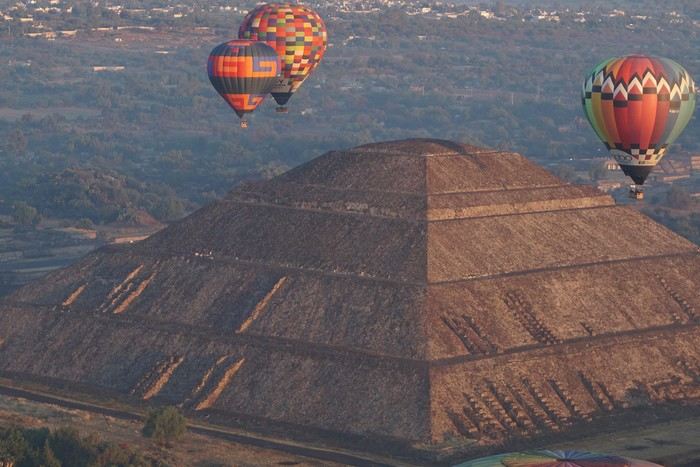
This one-month trip, from January 18 to February 17, 2026, allowed us to visit Mexico City and travel through the states of Puebla, Oaxaca, and Chiapas. We mainly used buses (ADO company) for medium and long distances and colectivos or taxis (or Uber) for shorter trips. Before leaving, I had contacted several people on the ground: Harry, a Vendéan settled in Oaxaca offering, among other things, discoveries of artisan villages or the Monte Albán site, and Oscar in Comitán de Domínguez. I’ll come back to our meeting with Oscar, who runs a local agency (CVL Travel Turismo Alternativo & Corre la voz) and owns a very pleasant hostel, a real highlight of our trip. Our journey took place in 8 stages on a loop starting from Mexico City. The connections between each were made by day or night buses depending on the trip duration. I had booked our seats in advance, either directly on the ADO company’s website or through booking platforms depending on the rates offered. Note that by planning ahead, I was able to benefit from very interesting "Early Booking" rates. There are several comfort classes. For all our trips, I had booked seats in Primera class buses, except for two in GL (Grand Luxe) class. The rates are very reasonable, and the buses turned out to be comfortable or even very comfortable (only the basic seat recline might surprise you).
Our itinerary and number of days per stage: Stage 1 – Mexico City: 4 days Stage 2 – Puebla: 2 days Stage 3 – Oaxaca: 4 days Stage 4 – San Agustinillo: 4 days Stage 5 – San Cristóbal de las Casas: 3 days Stage 6 – Comitán de Domínguez: 6 days Stage 7 – Palenque: 4 days Stage 8 – Mexico City: 2 days If I were to do it again, I’d remove one day from Palenque and add it either to Puebla or San Cristóbal to visit nearby sites or villages, or to San Agustinillo to enjoy one more day by the Pacific Ocean.
Stage 1: Mexico City (2,200 m / 9.2 million inhabitants) We arrived in the Mexican capital around 10:00 PM. The simplified customs process was very quick. After exchanging some money at the airport, we took a taxi to our youth hostel. We got around the capital on foot, of course, but also by metro. Signs are very rare, and we took the train in the wrong direction several times. After a few mistakes, we systematically asked on the platform if we were going the right way. The metro is very affordable. You need to get a rechargeable card (the Tarjeta de Movilidad Integrada) and top it up as needed. This card (less than 1 €) isn’t personal, so there’s no need to get one per person.
Mexico City: Day 1.
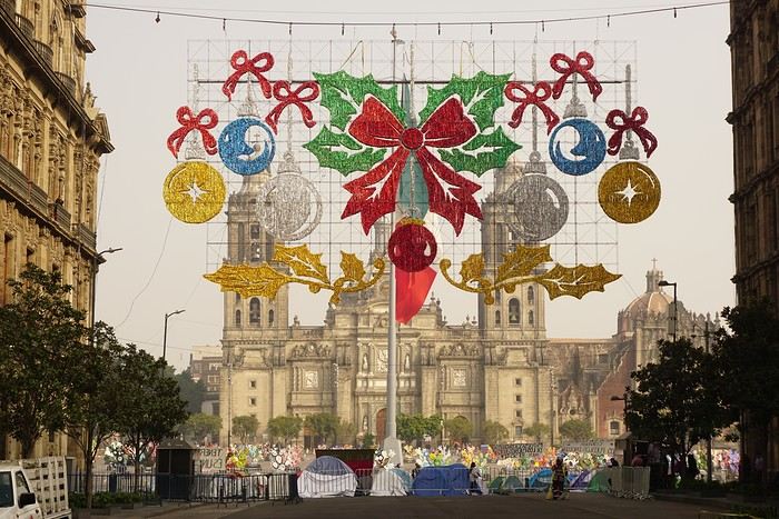
Visits and walks of the day (note: many museums are closed on Mondays): The Zócalo or Constitution Square: it’s one of the most beautiful, largest (195m x 240m), and oldest squares in the world. This is where Cortés decided to build the center of the new Spanish city on the site of the former Tenochtitlan market. Stones from the pyramids were used to pave the esplanade and build the surrounding colonial churches and buildings. During our visit, the huge square was covered with (resin) cacti, the theme of the temporary exhibition at the time. Indeed, temporary events or exhibitions take place here throughout the year. It’s also the endpoint for many protest marches.
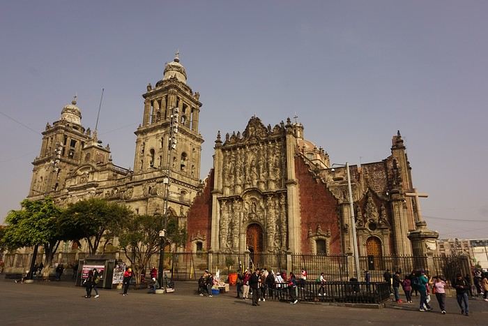
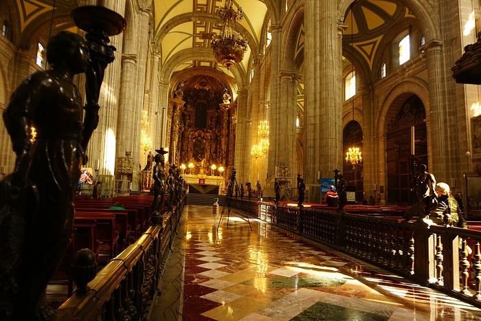


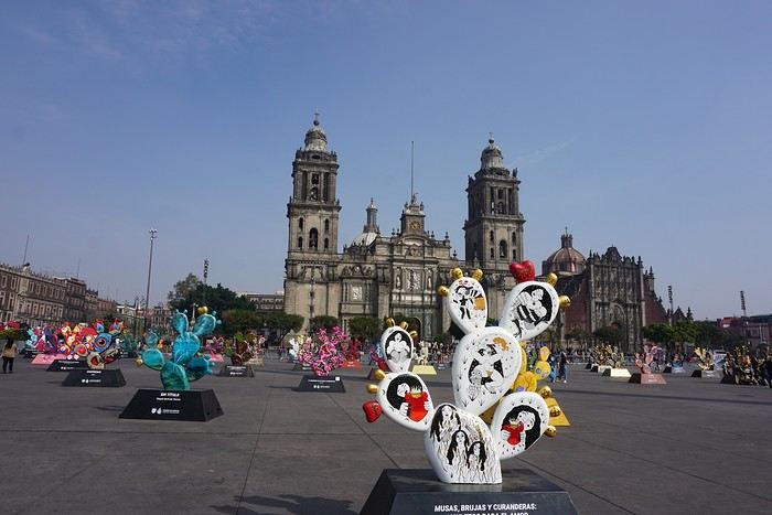
The cathedral: it’s sinking by one centimeter per year despite massive stabilization work (the collapse of many Mexican buildings—30 cm/year—is due to groundwater pumping). It was built starting in 1571 and completed in... 1813. The modest remains of the Templo Mayor (exterior view): they have high symbolic value, as this monument was the most important in the Mexica Empire.
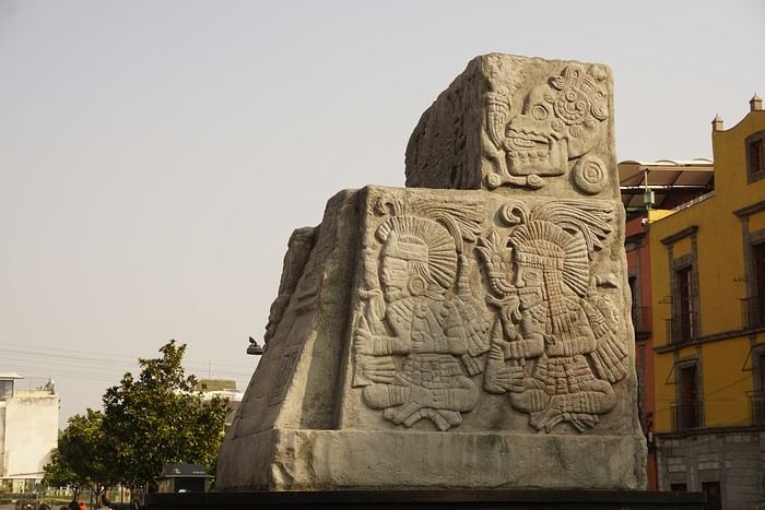 We then walked through the streets of the historic center to the Santísima Church, unfortunately closed for renovation work.
Next, we took the metro to visit one of Mexico’s most important pilgrimage sites: the Insigne y Nacional Basílicas de Santa María de Guadalupe, as well as the Capilla del Cerrito on the hill.
The first, dating from the colonial era, is really leaning a lot.
We then walked through the streets of the historic center to the Santísima Church, unfortunately closed for renovation work.
Next, we took the metro to visit one of Mexico’s most important pilgrimage sites: the Insigne y Nacional Basílicas de Santa María de Guadalupe, as well as the Capilla del Cerrito on the hill.
The first, dating from the colonial era, is really leaning a lot.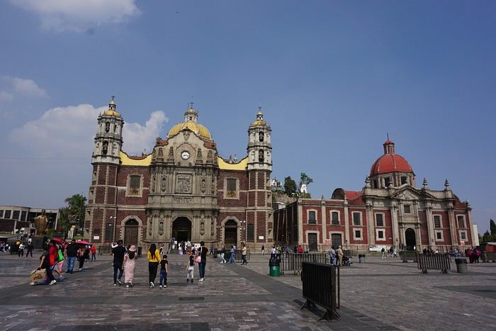
The second, shaped like a rotunda, is very impressive from the inside.
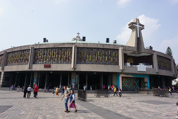
In the basement, there’s a sacred tunic where, in 1531, an image of the Virgin Mary is said to have appeared. A real mystery for scientists, the garment has never deteriorated since that date. Slow-moving conveyor belts allow pilgrims to admire it, preventing crowds from gathering in front of the image for hours. Well thought out!
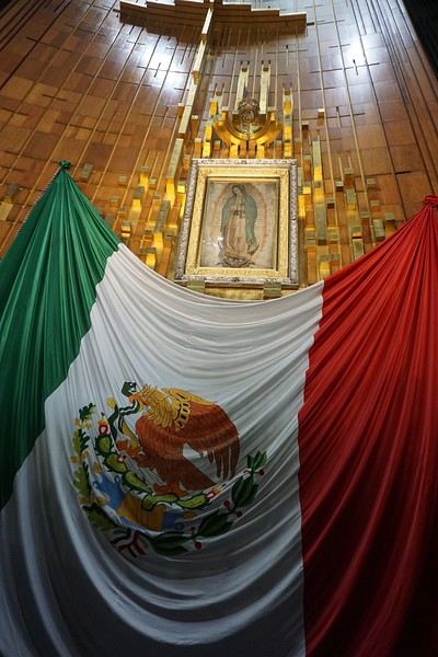 From the top of the Capilla del Cerrito, you get beautiful views of huge Mexico City.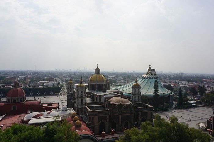
Your tips and recommendations for a trip through southern Morocco
Hello VF friends!
We’re planning to leave Marrakesh by rental car—this will be our second trip to Morocco. While we want to revisit some places, we also hope to explore new regions. Here’s the start of our itinerary, which could take 2 to 3 weeks. We don’t want to cover too many kilometers each day.
- Depart Marrakech for Essaouira, stopping to visit the Inzerki beehive. We’ll stay 3 nights in Essaouira to explore the city and the surrounding area. - Head toward Tamanar or that region for another 3 nights, exploring on a star-shaped route. We’d like to see the Paradise Valley and the coast. Not really keen on stopping in Agadir.
We’ve been to Tafraoute before, but I’d love to see some *greniers* (granaries) again, so we’re considering 1 or 2 nights there.
- Tiznit for 2 nights, making our way to Plage Blanche. - Guelmin and the Tighmert oasis for 2 nights. - Tata for 2 nights, visiting Akka Iguane and other villages.
After that, we’ll head east.
We’d love to hear about your experiences, great tips, and recommendations!
Thanks so much, and happy holidays!
- Depart Marrakech for Essaouira, stopping to visit the Inzerki beehive. We’ll stay 3 nights in Essaouira to explore the city and the surrounding area. - Head toward Tamanar or that region for another 3 nights, exploring on a star-shaped route. We’d like to see the Paradise Valley and the coast. Not really keen on stopping in Agadir.
We’ve been to Tafraoute before, but I’d love to see some *greniers* (granaries) again, so we’re considering 1 or 2 nights there.
- Tiznit for 2 nights, making our way to Plage Blanche. - Guelmin and the Tighmert oasis for 2 nights. - Tata for 2 nights, visiting Akka Iguane and other villages.
After that, we’ll head east.
We’d love to hear about your experiences, great tips, and recommendations!
Thanks so much, and happy holidays!
Join me in discovering Gran Canaria
Introduction
We stayed on the island of Gran Canaria during the first three months of 2024. It’s the third Canary Island we’ve visited, after Tenerife and Lanzarote.
We rented an apartment in Temisas. By staying in the same place for such a long period, the total price dropped by 50%.
We also rented a vehicle to make getting around the island easier.
Why the Canary Islands, and Gran Canaria in particular? For its pleasant climate, the nature and diversity of its landscapes, the charming villages, and especially the beauty of its many beaches.
In this travel journal, you’ll find a list of the many activities we did during our stay to explore the different attractions of this island.
These attractions are categorized to make it easier to find what interests you.
Videos are included throughout the summary. Click on the image to start the video.
To jump to a specific post, here are the relevant links:
HIKES:
Roque Nublo Maspalomas Dunes - Part 1 Maspalomas Dunes - Part 2 Los Azulejos de Veneguera Barranco de Las Vacas Ventana del Bentayga (Arco del Aserrador) Caves of the King Ventana de Morro (Ventana de la Ganifa) The Dog of Bentayga Cave of the Four Doors Ventana del Nublo Artenera - Caves of Acusa Seca Temisas - El Gigante Cave Fortress of Ansite Puerto de Las Nieves - Roque de Las Nieves Temisas - Cuevas de la Audiencia Roque Bentayga Guayadeque Ravine (Guayadeque Hermitage) Guayadeque Ravine (Cueva de Bartalo) El Zumacal - Barranco Tauco Casablanca Dam (Los Dolores Dam) Ayagaures - La Angostura Dam & Gambuesa Dam Santa Brígida - Alonso Ravine & Centennial Dragon Tree Pino Santo Hike in the Azuaje Ravine Gáldar - Red Lands of Samarrita Tejeda - Charco de La Paloma Bandama Boiler (Camino Borde de Caldera Bandama) Teror - Alamo Ravine Trail – SL-4 Telde - Calasio Caves Special Natural Reserve of Los Tilos de Moya Los Azulejos - Charco de Las Aneas Fataga Ravine Arinaga Military Battery Trail Maspalomas - Las Fuentes and del Canizo Ravines Mogán - Tauro Mountain Trail Tamabada - Llanos de La Mimbre & Sobre la Cueva Viewpoints Trail Hike to the Coronadero Arch via Barranco Hondo Barranco de Silva - Hike to the Jerez Caves Gáldar - Samson Cave - La Atalaya Peak Agaete - Roque Guayedra and Guayedra Ravine Artenara - Caballero Caves Arucas - Bufadero Salt Flats Barranco de Pino Gordo - Natural Pools Telde - Los Cernícalos Ravine Las Cruces - Toba Caves & Picón Puerto de Las Nieves - Moro Cave Agüimes - Morros de Ávila Caves Juncalillo del Sur - Laguna & Salinas de Abajo Caves of Camino de San Felipe Cruz de Tejeda, Cruz Chico and Degollada Viewpoint Hike on the Patalavaca Circuit Motor Grande - Puerto Rico Arch El Montañón - Los Hornos Dam Seafront Walk - Amadores Beach – Puerto Rico Beach Las Niñas Dam El Hornillo - Omega & Omicron Caves Arteara Necropolis Mogán - El Mulato Dam Las Garzas - El Regante Dam La Plata Route - Cho Flores Dam & El Charco Hondo Vega de Acusa - La Candelaria Dam Candelaria Hermitage – Acusa Seca Viewpoint Valsequillo de Gran Canaria – Roque La Vela Ayagaures Dam – GC-602 Lomo del Palo - Monte Pavón Trail Lugar La Laguna - Levada Fataga Dam & Ravine
BEACHES:
Mogán Beach Taurito Beach Tauro Beach Amadores Beach Puerto Rico Beach Anfi del Mar Beach Patalavaca Beach Meloneras Beach Maspalomas Beach English Beach (Playa del Inglés) Las Burras Beach San Agustin Beach Las Alcaravaneras Beach Las Canteras Beach (La Cicer) Las Canteras Beach (La Puntilla) Las Canteras Beach (Santa Catalina) Aquamarina Beach El Agujero - Bocabarranco Beach Hoya Del Pozo Beach Hoya Del Pozo Beach - Lizard with amputated tail El Cabron Beach Ojos de Garza Beach El Burrero Beach
NATURAL POOLS:
Charco Azul - El Risco Agaete Salt Flats Charco de Los Espejos - Sardina del Norte Natural Pools of Punta de Gáldar Snorkeling in the natural pool of Punta de Gáldar Natural Pool La Furnia o El Clavo - Gáldar Natural Pool of Los Dos Roques Emiliano Natural Pool - El Agujero Natural Pool of El Agujero Natural Pools of Roque Prieto Natural Pool El Altillo Los Charcones de Bañaderos – Arucas Natural Pools of El Charco de Las Palomas – Arucas Natural Pools of La Laja - Las Palmas de Gran Canaria Cueva de la Reina Mora - La Garita Natural Pools of Castillo del Romeral
TOWNS:
Center
Santa Brigida Vega de San Mateo Tejeda Artenara Vallesco Teror
Southwest
Santa Lucia de Tirajana Fataga San Bartolomé de Tirajana Puerto de Mogán La Aldea de San Nicolas
North
Arucas Firgas Moya Santa Maria de Guia Gáldar Agaete Puerto de Las Nieves
East
Vegueta - Las Palmas de Gran Canaria Triana - Las Palmas de Gran Canaria Ciudad Jardin - Las Palmas de Gran Canaria Canteras - Las Palmas de Gran Canaria Telde Valsequillo de Gran Canaria Ingenio Agüimes Temisas
VIEWPOINTS:
GC-60 Route (or nearby) GC-210 Route (or nearby) GC-210 Route between the tunnel and La Aldea de San Nicolás GC-215 & GC-65 Routes (or nearby) GC-200 Route (or nearby) GC-130 Route (or nearby) & GC-605 GC-70 Route (or nearby) & GC-21 Sheep herd on GC-70 Route GC-150, GC-240, GC-305, GC-350 & GC-301 Routes GC-606, GC-295, GC-231 and GC-41 Routes (or nearby) Viewpoints – GC-1 Route (or nearby) Viewpoints - Las Palmas de Gran Canaria Viewpoints - GC-2, GC-21, GC-15, GC-216 and GC-132 Routes (or nearby) Viewpoints - GC-503 & GC-217 Routes Viewpoints - GC-604, GC-505, GC-132, GC-42 and GC-802 Routes
MISCELLANEOUS:
San Rafael Aqueduct - Telde Abandoned San Rafael Estate - La Higuera Cenobio de Valerón La Cesta - Tejeda Puerto de la Aldea Scenic Route GC-671 to El Espinillo Scenic Route GC-607 to El Chorrillo The Galdar Cube (Santiago Quarry) Scenic Route GC-504 to Ayagaures Abandoned seaside resort in the Azuaje Ravine El Bufadero de La Garita – Telde GC-505 Route Abandoned Finca Las Haciendas (Los Mocanes) – Las Vegas de Valsequillo Ruins of San Juan Battery - Las Palmas de Gran Canaria Viera y Clavijo Canarian Botanical Garden - Las Palmas de Gran Canaria Tenefé Salt Flats Los Pérez, Lugarejos & Las Hoyas Dams Monte Pavón, Gran Canaria’s little Ireland Valleseco Lagoon Recreational Area Climbing - Fataga Ravine Surfing – El Agujero El Cairete Restaurant - Carrizal de Tejeda Paragliding flight observation - Los Giles La Cuevita Ayagaures Restaurant Statues and Murals - Cruce de Arinaga Aviation Monument (Las Majoreras) & Murals – Carrizal Artistic recycling by Antonio Peñita - Ojos de Garza Rainbows
We stayed on the island of Gran Canaria during the first three months of 2024. It’s the third Canary Island we’ve visited, after Tenerife and Lanzarote.
We rented an apartment in Temisas. By staying in the same place for such a long period, the total price dropped by 50%.
We also rented a vehicle to make getting around the island easier.
Why the Canary Islands, and Gran Canaria in particular? For its pleasant climate, the nature and diversity of its landscapes, the charming villages, and especially the beauty of its many beaches.
In this travel journal, you’ll find a list of the many activities we did during our stay to explore the different attractions of this island.
These attractions are categorized to make it easier to find what interests you.
Videos are included throughout the summary. Click on the image to start the video.
To jump to a specific post, here are the relevant links:
HIKES:
Roque Nublo Maspalomas Dunes - Part 1 Maspalomas Dunes - Part 2 Los Azulejos de Veneguera Barranco de Las Vacas Ventana del Bentayga (Arco del Aserrador) Caves of the King Ventana de Morro (Ventana de la Ganifa) The Dog of Bentayga Cave of the Four Doors Ventana del Nublo Artenera - Caves of Acusa Seca Temisas - El Gigante Cave Fortress of Ansite Puerto de Las Nieves - Roque de Las Nieves Temisas - Cuevas de la Audiencia Roque Bentayga Guayadeque Ravine (Guayadeque Hermitage) Guayadeque Ravine (Cueva de Bartalo) El Zumacal - Barranco Tauco Casablanca Dam (Los Dolores Dam) Ayagaures - La Angostura Dam & Gambuesa Dam Santa Brígida - Alonso Ravine & Centennial Dragon Tree Pino Santo Hike in the Azuaje Ravine Gáldar - Red Lands of Samarrita Tejeda - Charco de La Paloma Bandama Boiler (Camino Borde de Caldera Bandama) Teror - Alamo Ravine Trail – SL-4 Telde - Calasio Caves Special Natural Reserve of Los Tilos de Moya Los Azulejos - Charco de Las Aneas Fataga Ravine Arinaga Military Battery Trail Maspalomas - Las Fuentes and del Canizo Ravines Mogán - Tauro Mountain Trail Tamabada - Llanos de La Mimbre & Sobre la Cueva Viewpoints Trail Hike to the Coronadero Arch via Barranco Hondo Barranco de Silva - Hike to the Jerez Caves Gáldar - Samson Cave - La Atalaya Peak Agaete - Roque Guayedra and Guayedra Ravine Artenara - Caballero Caves Arucas - Bufadero Salt Flats Barranco de Pino Gordo - Natural Pools Telde - Los Cernícalos Ravine Las Cruces - Toba Caves & Picón Puerto de Las Nieves - Moro Cave Agüimes - Morros de Ávila Caves Juncalillo del Sur - Laguna & Salinas de Abajo Caves of Camino de San Felipe Cruz de Tejeda, Cruz Chico and Degollada Viewpoint Hike on the Patalavaca Circuit Motor Grande - Puerto Rico Arch El Montañón - Los Hornos Dam Seafront Walk - Amadores Beach – Puerto Rico Beach Las Niñas Dam El Hornillo - Omega & Omicron Caves Arteara Necropolis Mogán - El Mulato Dam Las Garzas - El Regante Dam La Plata Route - Cho Flores Dam & El Charco Hondo Vega de Acusa - La Candelaria Dam Candelaria Hermitage – Acusa Seca Viewpoint Valsequillo de Gran Canaria – Roque La Vela Ayagaures Dam – GC-602 Lomo del Palo - Monte Pavón Trail Lugar La Laguna - Levada Fataga Dam & Ravine
BEACHES:
Mogán Beach Taurito Beach Tauro Beach Amadores Beach Puerto Rico Beach Anfi del Mar Beach Patalavaca Beach Meloneras Beach Maspalomas Beach English Beach (Playa del Inglés) Las Burras Beach San Agustin Beach Las Alcaravaneras Beach Las Canteras Beach (La Cicer) Las Canteras Beach (La Puntilla) Las Canteras Beach (Santa Catalina) Aquamarina Beach El Agujero - Bocabarranco Beach Hoya Del Pozo Beach Hoya Del Pozo Beach - Lizard with amputated tail El Cabron Beach Ojos de Garza Beach El Burrero Beach
NATURAL POOLS:
Charco Azul - El Risco Agaete Salt Flats Charco de Los Espejos - Sardina del Norte Natural Pools of Punta de Gáldar Snorkeling in the natural pool of Punta de Gáldar Natural Pool La Furnia o El Clavo - Gáldar Natural Pool of Los Dos Roques Emiliano Natural Pool - El Agujero Natural Pool of El Agujero Natural Pools of Roque Prieto Natural Pool El Altillo Los Charcones de Bañaderos – Arucas Natural Pools of El Charco de Las Palomas – Arucas Natural Pools of La Laja - Las Palmas de Gran Canaria Cueva de la Reina Mora - La Garita Natural Pools of Castillo del Romeral
TOWNS:
Center
Santa Brigida Vega de San Mateo Tejeda Artenara Vallesco Teror
Southwest
Santa Lucia de Tirajana Fataga San Bartolomé de Tirajana Puerto de Mogán La Aldea de San Nicolas
North
Arucas Firgas Moya Santa Maria de Guia Gáldar Agaete Puerto de Las Nieves
East
Vegueta - Las Palmas de Gran Canaria Triana - Las Palmas de Gran Canaria Ciudad Jardin - Las Palmas de Gran Canaria Canteras - Las Palmas de Gran Canaria Telde Valsequillo de Gran Canaria Ingenio Agüimes Temisas
VIEWPOINTS:
GC-60 Route (or nearby) GC-210 Route (or nearby) GC-210 Route between the tunnel and La Aldea de San Nicolás GC-215 & GC-65 Routes (or nearby) GC-200 Route (or nearby) GC-130 Route (or nearby) & GC-605 GC-70 Route (or nearby) & GC-21 Sheep herd on GC-70 Route GC-150, GC-240, GC-305, GC-350 & GC-301 Routes GC-606, GC-295, GC-231 and GC-41 Routes (or nearby) Viewpoints – GC-1 Route (or nearby) Viewpoints - Las Palmas de Gran Canaria Viewpoints - GC-2, GC-21, GC-15, GC-216 and GC-132 Routes (or nearby) Viewpoints - GC-503 & GC-217 Routes Viewpoints - GC-604, GC-505, GC-132, GC-42 and GC-802 Routes
MISCELLANEOUS:
San Rafael Aqueduct - Telde Abandoned San Rafael Estate - La Higuera Cenobio de Valerón La Cesta - Tejeda Puerto de la Aldea Scenic Route GC-671 to El Espinillo Scenic Route GC-607 to El Chorrillo The Galdar Cube (Santiago Quarry) Scenic Route GC-504 to Ayagaures Abandoned seaside resort in the Azuaje Ravine El Bufadero de La Garita – Telde GC-505 Route Abandoned Finca Las Haciendas (Los Mocanes) – Las Vegas de Valsequillo Ruins of San Juan Battery - Las Palmas de Gran Canaria Viera y Clavijo Canarian Botanical Garden - Las Palmas de Gran Canaria Tenefé Salt Flats Los Pérez, Lugarejos & Las Hoyas Dams Monte Pavón, Gran Canaria’s little Ireland Valleseco Lagoon Recreational Area Climbing - Fataga Ravine Surfing – El Agujero El Cairete Restaurant - Carrizal de Tejeda Paragliding flight observation - Los Giles La Cuevita Ayagaures Restaurant Statues and Murals - Cruce de Arinaga Aviation Monument (Las Majoreras) & Murals – Carrizal Artistic recycling by Antonio Peñita - Ojos de Garza Rainbows
Come discover the island of Madeira with me
Introduction
We arrived on the island of Madeira (Portugal) at the beginning of May 2023 and stayed for 5 weeks.
This island is renowned for its rich cultural heritage, its famous hikes through lush landscapes, and its seaside resorts. It offers an unforgettable experience for nature lovers.
In this travel journal, you’ll find a list of the many activities we did during our stay to explore the different attractions of this magnificent island.
These attractions are categorized to make it easier to search based on your interests, if needed.
Videos are included throughout the summary. Please click on the image to start the video.
To jump to a specific post, here are the appropriate links:
HIKES:
Calheta - PR19 Caminho Real do Paúl do Mar Santana - Ribeiro Frio - PR11 Vereda dos Balcões Sao Vicente - Gingas - PR16 Levada Fajã do Rodrigues Rabaçal - PR6.1 Levada do Risco & PR6 Levada das 25 fontes Rabaçal - PR6.2 Levada do Alecrim & PR6.3 Vereda da Lagoa do Vento Caniçal - PR8 Vereda da Ponta de São Lourenço São Jorge - PR18 Levada do Rei Ponta do Sol - PR7 modified - Levada Nova & Levada do Moinho Machico - PR5 Vereda das Funduras Funchal - PR1 Vereda do Areeiro (Pico do Areeiro to Pico Ruivo) Funchal - PR1 Vereda do Areeiro (Pico Ruivo to Pico do Areeiro) Funchal - PR1.2 Vereda do Pico Ruivo (outbound) Funchal - PR1.2 Vereda do Pico Ruivo (return) Porto Moniz - Fanal Forest Porto Moniz - PR14 Levada dos Cedros Ribeira Brava - PR17 Caminho do Pináculo e Folhadal (Encumeada) Ribeira Brava - PR17 Caminho do Pináculo e Folhadal (Lombo do Mouro) Ribeira Brava - PR17 Caminho do Pináculo e Folhadal (Bica da Cana) Santana - PR9 Levada do Caldeirão Verde Lamaceiros - Levada Ribeira da Janela Ribeiro Frio - PR10 Levada do Furado Tabua - Levada da Nova (Eastern Sector) Tabua - Levada da Nova (Western Sector) Boa Morte - Levada do Norte Verada da Levada do Facho - Levada do Norte (South) Vale Paraiso - Levada da Serra do Faial Porto Moniz - PR13 Vereda do Fanal Referta - Levada do Castelejo Porto da Cruz - Levada do Castelejo Estanquinhos - Pico Ruivo do Paul da Serra Boaventura - Levada de Cima & Levada da Acha Grande
SEASIDE RESORTS & NATURAL POOLS:
Natural pools of Seixal Seixal Naval Club Seaside Resort - Natural pool Natural pools of Porto Moniz Funchal - Lido Seaside Resort Santana - Foz da Ribeira do Faial Seaside Resort Câmara de Lobos - Salinas Seaside Resort Porto Moniz - Aquário/Cachalote Natural Pools Funchal - Doca do Cavacas Seaside Resort Funchal - Ponta Gorda Seaside Resort Caniço - Roca Mar Hotel Seaside Resort Caniço - Lido Galoma Seaside Resort Calhau de São Jorge Seaside Resort Ribeira Brava Seaside Resort
BEACHES:
São Jorge Beach Calheta Beach Seixal - Laje Beach (Jamaica) Porto de Seixal Beach Caniço - Reis Magos Beach Machico - Machico Beach (Banda d'Além) Machico - São Roque Beach Machico - Ribeira Natal Beach Caniçal - Prainha Beach Porto da Cruz - Alagoa Beach
TOWNS:
Stroll through the town of Ponta do Sol Stroll through the town of Câmara de Lobos Stroll through the town of Ribeira Brava Stroll through the town of Funchal Funchal - Wicker toboggan ride Stroll through the town of Machico Stroll through the town of Santana Stroll through the town of São Vicente São Vicente Caves Park
VIEWPOINTS:
Calheta Region Ponta do Sol Region Ribeira Brava Region Câmara de Lobos Region Funchal Region Santa Cruz Region Porto Moniz Region São Vicente Region Santana Region Machico Region On the road in Madeira
WATERFALLS ALONG THE WAY
Ponta do Sol - Anjos Waterfall Sao Vicente - Água d'Alto Waterfall Seixal - Córrego da Furna Waterfall
We arrived on the island of Madeira (Portugal) at the beginning of May 2023 and stayed for 5 weeks.
This island is renowned for its rich cultural heritage, its famous hikes through lush landscapes, and its seaside resorts. It offers an unforgettable experience for nature lovers.
In this travel journal, you’ll find a list of the many activities we did during our stay to explore the different attractions of this magnificent island.
These attractions are categorized to make it easier to search based on your interests, if needed.
Videos are included throughout the summary. Please click on the image to start the video.
To jump to a specific post, here are the appropriate links:
HIKES:
Calheta - PR19 Caminho Real do Paúl do Mar Santana - Ribeiro Frio - PR11 Vereda dos Balcões Sao Vicente - Gingas - PR16 Levada Fajã do Rodrigues Rabaçal - PR6.1 Levada do Risco & PR6 Levada das 25 fontes Rabaçal - PR6.2 Levada do Alecrim & PR6.3 Vereda da Lagoa do Vento Caniçal - PR8 Vereda da Ponta de São Lourenço São Jorge - PR18 Levada do Rei Ponta do Sol - PR7 modified - Levada Nova & Levada do Moinho Machico - PR5 Vereda das Funduras Funchal - PR1 Vereda do Areeiro (Pico do Areeiro to Pico Ruivo) Funchal - PR1 Vereda do Areeiro (Pico Ruivo to Pico do Areeiro) Funchal - PR1.2 Vereda do Pico Ruivo (outbound) Funchal - PR1.2 Vereda do Pico Ruivo (return) Porto Moniz - Fanal Forest Porto Moniz - PR14 Levada dos Cedros Ribeira Brava - PR17 Caminho do Pináculo e Folhadal (Encumeada) Ribeira Brava - PR17 Caminho do Pináculo e Folhadal (Lombo do Mouro) Ribeira Brava - PR17 Caminho do Pináculo e Folhadal (Bica da Cana) Santana - PR9 Levada do Caldeirão Verde Lamaceiros - Levada Ribeira da Janela Ribeiro Frio - PR10 Levada do Furado Tabua - Levada da Nova (Eastern Sector) Tabua - Levada da Nova (Western Sector) Boa Morte - Levada do Norte Verada da Levada do Facho - Levada do Norte (South) Vale Paraiso - Levada da Serra do Faial Porto Moniz - PR13 Vereda do Fanal Referta - Levada do Castelejo Porto da Cruz - Levada do Castelejo Estanquinhos - Pico Ruivo do Paul da Serra Boaventura - Levada de Cima & Levada da Acha Grande
SEASIDE RESORTS & NATURAL POOLS:
Natural pools of Seixal Seixal Naval Club Seaside Resort - Natural pool Natural pools of Porto Moniz Funchal - Lido Seaside Resort Santana - Foz da Ribeira do Faial Seaside Resort Câmara de Lobos - Salinas Seaside Resort Porto Moniz - Aquário/Cachalote Natural Pools Funchal - Doca do Cavacas Seaside Resort Funchal - Ponta Gorda Seaside Resort Caniço - Roca Mar Hotel Seaside Resort Caniço - Lido Galoma Seaside Resort Calhau de São Jorge Seaside Resort Ribeira Brava Seaside Resort
BEACHES:
São Jorge Beach Calheta Beach Seixal - Laje Beach (Jamaica) Porto de Seixal Beach Caniço - Reis Magos Beach Machico - Machico Beach (Banda d'Além) Machico - São Roque Beach Machico - Ribeira Natal Beach Caniçal - Prainha Beach Porto da Cruz - Alagoa Beach
TOWNS:
Stroll through the town of Ponta do Sol Stroll through the town of Câmara de Lobos Stroll through the town of Ribeira Brava Stroll through the town of Funchal Funchal - Wicker toboggan ride Stroll through the town of Machico Stroll through the town of Santana Stroll through the town of São Vicente São Vicente Caves Park
VIEWPOINTS:
Calheta Region Ponta do Sol Region Ribeira Brava Region Câmara de Lobos Region Funchal Region Santa Cruz Region Porto Moniz Region São Vicente Region Santana Region Machico Region On the road in Madeira
WATERFALLS ALONG THE WAY
Ponta do Sol - Anjos Waterfall Sao Vicente - Água d'Alto Waterfall Seixal - Córrego da Furna Waterfall
Cycling Algeria’s Coast – January 2025 Trip Report
Hi everyone,
First post here to share a quick recap of our west-to-east bike trip along Algeria’s coast in January 2025. It was just the two of us—my partner and I—with French passports and not a word of Arabic. No friends or welcoming hosts in the country.
Under those conditions, we’d strongly advise against going.
Our original plan was to follow the coast from Algiers to Tunis. We ended up cycling from Algiers to Béjaia, then took the train from Béjaia to Annaba (with a stop in Constantine), and finally biked to the border. We were tailed by police the whole way—whether on our bikes, on the train, or even on foot while exploring towns. On top of that, we couldn’t wild camp and were limited to the few state-approved hotels that accept foreigners. Under those circumstances, connecting with locals was especially tough.
With such an omnipresent and intrusive police presence, we’d definitely recommend against this destination for bike touring. A really sad situation that completely cuts you off from the local population...
We’d been warned, we went to check it out, and we weren’t disappointed!
You’ve been warned.
First post here to share a quick recap of our west-to-east bike trip along Algeria’s coast in January 2025. It was just the two of us—my partner and I—with French passports and not a word of Arabic. No friends or welcoming hosts in the country.
Under those conditions, we’d strongly advise against going.
Our original plan was to follow the coast from Algiers to Tunis. We ended up cycling from Algiers to Béjaia, then took the train from Béjaia to Annaba (with a stop in Constantine), and finally biked to the border. We were tailed by police the whole way—whether on our bikes, on the train, or even on foot while exploring towns. On top of that, we couldn’t wild camp and were limited to the few state-approved hotels that accept foreigners. Under those circumstances, connecting with locals was especially tough.
With such an omnipresent and intrusive police presence, we’d definitely recommend against this destination for bike touring. A really sad situation that completely cuts you off from the local population...
We’d been warned, we went to check it out, and we weren’t disappointed!
You’ve been warned.
4- to 5-day itinerary for Madagascar
Hi there, following a work trip, I’ll have 4.5 days left to get a quick overview of Madagascar during the last week of February. I’ll already have had a good look around Tana (3 days of work and 1.5 days beforehand to see 1 or 2 points of interest 2-3 hours from Tana).
Is it feasible to spend the remaining 4.5 days like this:
- Day 1 & 2 (and maybe the morning of Day 3): relaxing on a coast with a pleasant climate, for example, a one-way flight to Tuléar (there’s a flight on Day 1 at 3 AM) and heading to a nice beach. Ideally, I’d have liked to go toward Morondava (baobabs, beautiful beaches near Belo), but the flight schedules don’t really work, and it wouldn’t let me visit Isalo.
- Then 2 days to head back up via the RN7, ideally with a stop in Isalo, which really appeals to me (I’m an experienced hiker in France), and/or Ranomafana. But do the weather conditions allow for long hikes in that area? Ideally, I’d like to do Tuléar–Tana by public transport up to my first road stop (shared bus? To Isalo?), then find a local hiking guide for the day. And take another transport to another point of interest before returning to Tana, where I have my return flight to France on Day 5 at noon.
My questions: - How to travel from Day 3 to Day 5 from the west coast (Tuléar? Morondava?) back to Tana? I’d prefer not to depend on a guide the whole way, but if I have to 🤷🏽♂️) If I choose Morondava, will I miss out on really interesting spots I could’ve seen along the RN7?
I’m open to any suggestions or ideas to make the most of these 4.5 days, like another beach destination I might not have considered (I ruled out Nosy Bé because of the February weather—maybe I was wrong?)
Is it feasible to spend the remaining 4.5 days like this:
- Day 1 & 2 (and maybe the morning of Day 3): relaxing on a coast with a pleasant climate, for example, a one-way flight to Tuléar (there’s a flight on Day 1 at 3 AM) and heading to a nice beach. Ideally, I’d have liked to go toward Morondava (baobabs, beautiful beaches near Belo), but the flight schedules don’t really work, and it wouldn’t let me visit Isalo.
- Then 2 days to head back up via the RN7, ideally with a stop in Isalo, which really appeals to me (I’m an experienced hiker in France), and/or Ranomafana. But do the weather conditions allow for long hikes in that area? Ideally, I’d like to do Tuléar–Tana by public transport up to my first road stop (shared bus? To Isalo?), then find a local hiking guide for the day. And take another transport to another point of interest before returning to Tana, where I have my return flight to France on Day 5 at noon.
My questions: - How to travel from Day 3 to Day 5 from the west coast (Tuléar? Morondava?) back to Tana? I’d prefer not to depend on a guide the whole way, but if I have to 🤷🏽♂️) If I choose Morondava, will I miss out on really interesting spots I could’ve seen along the RN7?
I’m open to any suggestions or ideas to make the most of these 4.5 days, like another beach destination I might not have considered (I ruled out Nosy Bé because of the February weather—maybe I was wrong?)
Nothing’s stopping you from going to Ampefy (Madagascar)
During these three big weeks in Madagascar, one week in Sainte Marie, a few days for a little loop in the west/south, and the rest in Tana.
This loop I’m talking about covers an area I’d never taken the time to visit before. A recent road in good condition, the chance to pass through beautiful highland landscapes, and a few free days made it the perfect opportunity. Destination: Ampefy, west of Tana via the RN1, then a turn south onto the recently rehabilitated RN43 to reach Antsirabe before heading back to Tana. Four days planned—perfect, since an extra day wouldn’t have been a problem given all the activities in Ampefy.
First day: a relaxed and fairly late departure for Ampefy. We weren’t in a rush and took our time. Traffic leaving Tana to get back on the RN1 cost us the head start we had on our original schedule. An hour and a half bumper-to-bumper with the *buxis*, inching painfully toward the roundabout and then the bridge that acts as a bottleneck—we dove in like all our fellow sufferers. It’s not our everyday reality, and we were early, so no big deal, but man, it’s long and slow. Once past that obstacle, traffic flowed smoothly, and the road was good (all the way to Ampefy). We moved through highland landscapes, bustling villages full of activity, and countless agricultural supply shops—clear proof, if any were needed, that we were crossing a prime farming region. Around Arivonimamo, we passed through a forest with a Mediterranean vibe: a single-species forest of stout little trees with glossy, elongated light-green leaves—these are *tapia*. An endemic tree in Madagascar, and a pretty unique forest as a result (you can see them elsewhere, like between Antsirabe and Ambositra). There are efforts to protect it from illegal logging because the wood is fire-resistant, which helps shield the forest from wildfires. Beyond its biodiversity value, the *tapia* hosts silkworms, giving it economic and cultural importance.
As we kept going, we started spotting a lake and mountains with the rounded shapes typical of extinct volcanoes worn down by time and the elements. We were approaching Lake Itasy and, by extension, Ampefy. We stopped at a *hotely* for a plate of *tongon’kisoa*—pig’s trotters caramelized by cooking, with thick, flavorful skin—along with the obligatory portion of rice, which we took the time to drizzle with cooking juices to make it a bit more appetizing. Full, we turned left to reach Ampefy and our hotel. The landscape was dotted with collapsed, dormant volcanic cones, and suddenly, the view opened up onto the lake. Shallow and expansive, we followed it, losing sight of it now and then before finding it again in Ampefy itself, which we entered after crossing the Lily, a beautiful river that drains the lake. Lots of hotels and restaurants, with plenty of options at all price points. We chose the *Farihy*, about 5 km past Ampefy. A gorgeous spot by the lake, with a pool and lovely bungalows—some with picture windows overlooking the lake. Really nice. In the evening, a drink and some *sak sak* for aperitif on the terrace. It wasn’t warm, there was a lot of wind, and a storm was brewing. Off to bed quickly to start the next day’s visits.
After buying some lychees—we hadn’t seen many this year, and these were fresh from the field, picked in Ampefy—we headed to the Lily Falls. Well signposted, with a paved road in great condition, we stopped at the kiosk for the entrance fee and parking (1 euro for one *vahiny* and 10 cents for one Malagasy). We set off down the path and quickly reached the first waterfall, then continued for maybe 1 km on a well-marked trail to the second. A guide led us to the third, which is harder to spot and isn’t actually on the Lily itself. Beautiful countryside scenery: fishermen straight out of *Tom Sawyer*, straw hats on their heads, lying down with one foot hooked to a fragile bamboo rod, their line dipping into the calm river. Men preparing rice paddies with their *angady*, women transplanting rice, bent over the water. At some points, we walked along the dikes between paddies almost ready for harvest. It’s peaceful and beautiful when you’re strolling or fishing, but working the paddies is grueling, especially under that beating sun. A really nice walk—2 hours and a bit, going at a leisurely pace. A guide isn’t mandatory; only the entrance fee is. We took one because it provides a bit of work and puts money in the hands of locals, giving them more incentive to protect the site. But you can easily skip it, like most people do. Lots of visitors since it was the weekend—Tananarivians with family or groups of young people, scout groups organized under their chaperones’ direction. Very few foreign tourists, though—that’s a general observation. It’s great to see this growth in domestic tourism, giving Malagasy people the chance to discover their own country and allowing those in the sector to rely less on foreign visitors, who’ve been scarce for years.
Next, we headed to the "geysers" (which aren’t actually geysers, but whatever). We had to go back to the RN1, head toward Tsiroanomandidy, and a few kilometers later, a well-marked sign and a newly paved track led us to a pretty site. Again, lots of people, another kiosk, more fees to pay, and guides available. This time, we skipped the guide. A downpour caught us in front of the "geysers," so we took shelter under a little shop, grabbing an ice cream and some drinks. We didn’t stay long—we weren’t interested in a massage or a dip in the thermal water. The countryside and barren mountain landscapes were stunning on the way back to the hotel. We noticed you could go paragliding right in front of the bungalow, so we booked a session for the next morning. After eating at the *Auberge* in the town center (it was good), we headed back to the hotel to turn in early. Once again, a storm rolled in during the afternoon, and the temperature dropped significantly.
The next morning, around 8 a.m., we walked to the takeoff zone near the hotel. Towed by a small boat, we took off for a flight over the lake and the volcanic domes before landing back at the same spot. Two companies handle this. I’m no expert, but it seemed safe and well-organized.
To be continued...
First day: a relaxed and fairly late departure for Ampefy. We weren’t in a rush and took our time. Traffic leaving Tana to get back on the RN1 cost us the head start we had on our original schedule. An hour and a half bumper-to-bumper with the *buxis*, inching painfully toward the roundabout and then the bridge that acts as a bottleneck—we dove in like all our fellow sufferers. It’s not our everyday reality, and we were early, so no big deal, but man, it’s long and slow. Once past that obstacle, traffic flowed smoothly, and the road was good (all the way to Ampefy). We moved through highland landscapes, bustling villages full of activity, and countless agricultural supply shops—clear proof, if any were needed, that we were crossing a prime farming region. Around Arivonimamo, we passed through a forest with a Mediterranean vibe: a single-species forest of stout little trees with glossy, elongated light-green leaves—these are *tapia*. An endemic tree in Madagascar, and a pretty unique forest as a result (you can see them elsewhere, like between Antsirabe and Ambositra). There are efforts to protect it from illegal logging because the wood is fire-resistant, which helps shield the forest from wildfires. Beyond its biodiversity value, the *tapia* hosts silkworms, giving it economic and cultural importance.
As we kept going, we started spotting a lake and mountains with the rounded shapes typical of extinct volcanoes worn down by time and the elements. We were approaching Lake Itasy and, by extension, Ampefy. We stopped at a *hotely* for a plate of *tongon’kisoa*—pig’s trotters caramelized by cooking, with thick, flavorful skin—along with the obligatory portion of rice, which we took the time to drizzle with cooking juices to make it a bit more appetizing. Full, we turned left to reach Ampefy and our hotel. The landscape was dotted with collapsed, dormant volcanic cones, and suddenly, the view opened up onto the lake. Shallow and expansive, we followed it, losing sight of it now and then before finding it again in Ampefy itself, which we entered after crossing the Lily, a beautiful river that drains the lake. Lots of hotels and restaurants, with plenty of options at all price points. We chose the *Farihy*, about 5 km past Ampefy. A gorgeous spot by the lake, with a pool and lovely bungalows—some with picture windows overlooking the lake. Really nice. In the evening, a drink and some *sak sak* for aperitif on the terrace. It wasn’t warm, there was a lot of wind, and a storm was brewing. Off to bed quickly to start the next day’s visits.
After buying some lychees—we hadn’t seen many this year, and these were fresh from the field, picked in Ampefy—we headed to the Lily Falls. Well signposted, with a paved road in great condition, we stopped at the kiosk for the entrance fee and parking (1 euro for one *vahiny* and 10 cents for one Malagasy). We set off down the path and quickly reached the first waterfall, then continued for maybe 1 km on a well-marked trail to the second. A guide led us to the third, which is harder to spot and isn’t actually on the Lily itself. Beautiful countryside scenery: fishermen straight out of *Tom Sawyer*, straw hats on their heads, lying down with one foot hooked to a fragile bamboo rod, their line dipping into the calm river. Men preparing rice paddies with their *angady*, women transplanting rice, bent over the water. At some points, we walked along the dikes between paddies almost ready for harvest. It’s peaceful and beautiful when you’re strolling or fishing, but working the paddies is grueling, especially under that beating sun. A really nice walk—2 hours and a bit, going at a leisurely pace. A guide isn’t mandatory; only the entrance fee is. We took one because it provides a bit of work and puts money in the hands of locals, giving them more incentive to protect the site. But you can easily skip it, like most people do. Lots of visitors since it was the weekend—Tananarivians with family or groups of young people, scout groups organized under their chaperones’ direction. Very few foreign tourists, though—that’s a general observation. It’s great to see this growth in domestic tourism, giving Malagasy people the chance to discover their own country and allowing those in the sector to rely less on foreign visitors, who’ve been scarce for years.
Next, we headed to the "geysers" (which aren’t actually geysers, but whatever). We had to go back to the RN1, head toward Tsiroanomandidy, and a few kilometers later, a well-marked sign and a newly paved track led us to a pretty site. Again, lots of people, another kiosk, more fees to pay, and guides available. This time, we skipped the guide. A downpour caught us in front of the "geysers," so we took shelter under a little shop, grabbing an ice cream and some drinks. We didn’t stay long—we weren’t interested in a massage or a dip in the thermal water. The countryside and barren mountain landscapes were stunning on the way back to the hotel. We noticed you could go paragliding right in front of the bungalow, so we booked a session for the next morning. After eating at the *Auberge* in the town center (it was good), we headed back to the hotel to turn in early. Once again, a storm rolled in during the afternoon, and the temperature dropped significantly.
The next morning, around 8 a.m., we walked to the takeoff zone near the hotel. Towed by a small boat, we took off for a flight over the lake and the volcanic domes before landing back at the same spot. Two companies handle this. I’m no expert, but it seemed safe and well-organized.
To be continued...
From Caño Cristales to Tayrona Park
After about 12 hours of flying from Toulouse (via Paris), we landed in Bogotá six years after our first trip to Colombia. This time, our journey will be very different, with only this stop in the Colombian capital in common.
Our travel itinerary
Bogotá / La Macarena (Caño Cristales) / Villa de Leyva / Barichara / San Gil / Girón / Mompox / Ciénaga and the Santa Marta lagoon / Minca / Los Naranjos (Tayrona Park) / Bogotá.
Step 1: Bogotá (and Nemecon)
Bogotá (1/3)
This morning, we had a meet-up with Flora from Aventure Colombia, who helped me organize one of our stops, a few transfers, and tomorrow’s day trip, the program of which I changed at the last minute after deciding to skip the visit to the Salt Cathedral of Zipaquirá. Flora is a kind and lovely person, always available, and she did everything to answer my questions and give me advice.
She’s a local contact I highly recommend. Flora can help you plan your trip, whether you want a fully organized tour or, like us, just need assistance with a specific stop or one or more transfers between cities.
We left Flora after setting a meet-up for our return to Bogotá in a month. As we walked out of her agency, we headed to the wonderful Gold Museum, located just a hundred meters away. I was excited to revisit this amazing museum.
Note: Free entry for those over 60, regardless of nationality. Just show your passport.
Like six years ago, I was amazed by its museography, the beauty of the pieces on display, and that breathtaking shamanic room.
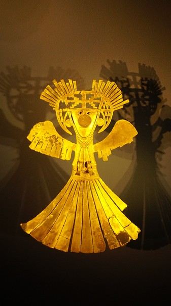
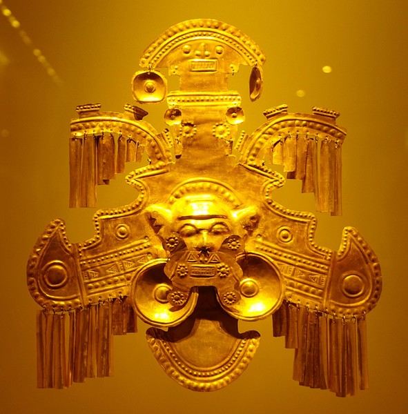
About two hours later, we decided to walk (careful, it’s a climb!) to the Monserrate cable car (3152m). Long wait to buy tickets and board the cable car! Once we arrived, a few raindrops, an impressive panoramic view of Bogotá’s vastness, a quick visit to the basilica (a pilgrimage site for Colombians), a walk through the tourist market, and at the top, plenty of small restaurants where we had our first Colombian meal. After our hearty lunch, we were lucky to see the sun return! No line for the descent. We then headed back to the hotel because Justine wanted to rest and recover from the trip. As for me, I continued my walk. I discovered a really nice craft market recommended by Flora, Pasaje Rivas, returned to Bolívar Square, and wandered through different streets, including the main pedestrian avenue (Calle 7), where there’s always something to see.
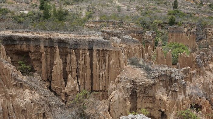
Tomorrow, a change of scenery as we head out for a hike in a small desert (Desierto de Chueca), located about 2 hours from Bogotá in the village of Nemecon. For this outing from Bogotá, with Flora’s help, we booked a car with a driver for the day. Flora also took care of booking the guide (since the site can only be visited with one). Nemecon (2/3) Today, we went to Nemecon to hike about 7.5 km in the ‘Desert of Checua.’ It’s nothing like sandy deserts! Instead, it’s geological formations sculpted by time, wind, and water. After two hours on the road—almost one of them spent navigating traffic jams with cars, trucks, buses, and a continuous flow of motorcycles on either side of our taxi—we reached Nemecon! The village center is really (too?) quiet. We met up with Deisy and headed toward the ‘desert,’ about twenty minutes away on a bumpy dirt road. Once there, a quick briefing, and off we went! Deisy didn’t stop talking (in Spanish) for over 3 hours!!! She told us so much about her region (flower farming, water management, traditions, songs, etc.), the origin of the site, and even mentioned Antonio Banderas, who filmed *The 33* in the village’s salt mine (the story of the survival of 33 Chilean miners after a collapse in their copper and gold mine). One hour of walking to reach the site, one hour to explore it, and one hour to return.
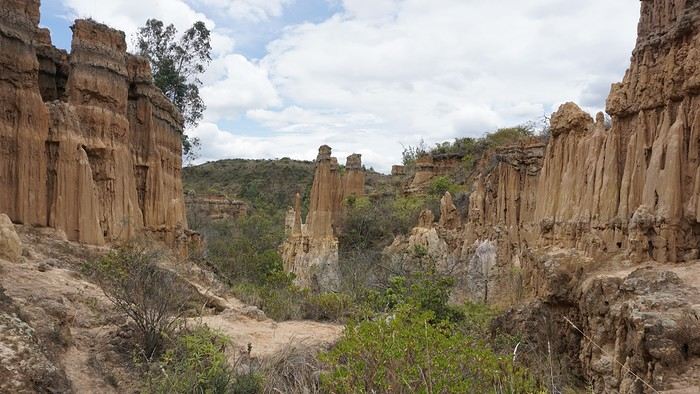
The advantage of this non-stop chatter was that it forced us to brush up on our Spanish at lightning speed. I even wondered if the effort to concentrate wasn’t more exhausting than the physical effort! Especially since on the way back, I got an oral quiz. Deisy wanted to make sure I remembered some of the information she’d given me during the visit: why is this rock white, that one red, and that one black? Back in the village, we had lunch at a restaurant recommended by Deisy before visiting the Nemecon salt mine. Before entering, a guide spent a good half-hour explaining the origin of the salt and the presence of many fossils in the area. Again, concentrating was tough because all the comments were exclusively in Spanish! An hour and a half wandering through the tunnels with a ‘lovely miner’s helmet’ on our heads!
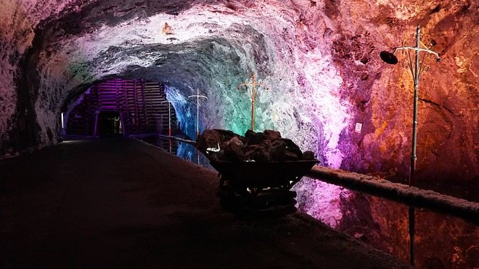
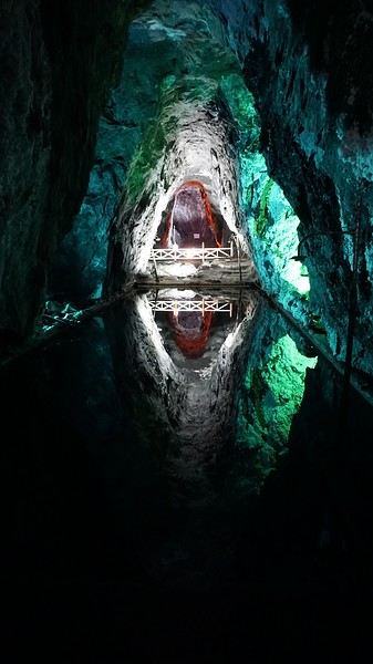
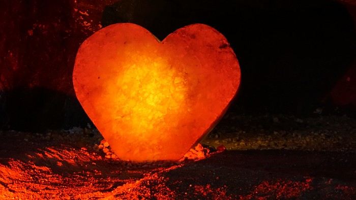
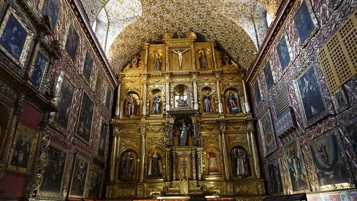
We met our driver at the mine entrance. The return to Bogotá was a bit faster, but traffic in the city center was still heavy! We arrived in front of our hotel between 8:00 and 8:30 PM. It’s been a pretty intense start to the trip! Tonight, our legs are tired. Hopefully, tomorrow will be a bit more relaxed! Bogotá (3/3) We started the day by visiting the Santa Clara Church Museum, located next to the presidential palace. Alejandra (from the local agency ‘Gaia Tours Colombia,’ which organized our stay in Caño Cristales (La Macarena)) had recommended this visit for its rich mural paintings.
A few hundred meters further, after crossing the Plaza Mayor again, we visited the cultural complex housing the Botero Museum, the Mint Museum, and the Bank of the Republic Art Museum. Note that entry is free for all three museums. Botero Museum: There are fewer works by Botero here than in the Medellín museum, but more paintings and sculptures by other artists, all from Botero’s private collection (donated to Colombia). Mint Museum: We limited ourselves to visiting one room (on Flora’s advice) where three gold and gemstone monstrances and a Christ with a crown of emerald thorns are displayed. Photos are not allowed. Art Museum: We visited two temporary exhibitions. Lunchtime came quickly. We had a good meal at a reasonably priced small restaurant in the La Candelaria micro-district, near the Chorro de Quevedo square. We decided to spend the afternoon wandering the streets and alleys of the historic center to discover local street art.
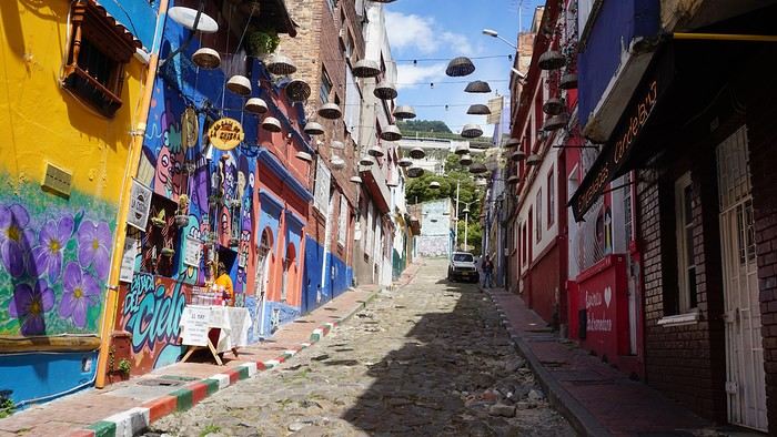
We also passed through very lively pedestrian streets. I also decided to revisit Pasaje Rivas to show Justine all the shops selling more or less artisanal products. Tomorrow morning, we fly to La Macarena at 10:30 AM. Not to dance (you’d be surprised if I told you we were going to take a South American dance class, right?!), but to visit the fabulous Caño Cristales, a river naturally colored by aquatic plants. The planned program includes hiking, horseback riding, canoeing, and swimming among these plants. This site was long inaccessible because the area was controlled by the FARC. Access and tourism development became possible after agreements and amnesty measures between the Colombian government and paramilitary groups. As in other regions, former FARC members have been able to transition into various tourism-related activities.
About two hours later, we decided to walk (careful, it’s a climb!) to the Monserrate cable car (3152m). Long wait to buy tickets and board the cable car! Once we arrived, a few raindrops, an impressive panoramic view of Bogotá’s vastness, a quick visit to the basilica (a pilgrimage site for Colombians), a walk through the tourist market, and at the top, plenty of small restaurants where we had our first Colombian meal. After our hearty lunch, we were lucky to see the sun return! No line for the descent. We then headed back to the hotel because Justine wanted to rest and recover from the trip. As for me, I continued my walk. I discovered a really nice craft market recommended by Flora, Pasaje Rivas, returned to Bolívar Square, and wandered through different streets, including the main pedestrian avenue (Calle 7), where there’s always something to see.
Tomorrow, a change of scenery as we head out for a hike in a small desert (Desierto de Chueca), located about 2 hours from Bogotá in the village of Nemecon. For this outing from Bogotá, with Flora’s help, we booked a car with a driver for the day. Flora also took care of booking the guide (since the site can only be visited with one). Nemecon (2/3) Today, we went to Nemecon to hike about 7.5 km in the ‘Desert of Checua.’ It’s nothing like sandy deserts! Instead, it’s geological formations sculpted by time, wind, and water. After two hours on the road—almost one of them spent navigating traffic jams with cars, trucks, buses, and a continuous flow of motorcycles on either side of our taxi—we reached Nemecon! The village center is really (too?) quiet. We met up with Deisy and headed toward the ‘desert,’ about twenty minutes away on a bumpy dirt road. Once there, a quick briefing, and off we went! Deisy didn’t stop talking (in Spanish) for over 3 hours!!! She told us so much about her region (flower farming, water management, traditions, songs, etc.), the origin of the site, and even mentioned Antonio Banderas, who filmed *The 33* in the village’s salt mine (the story of the survival of 33 Chilean miners after a collapse in their copper and gold mine). One hour of walking to reach the site, one hour to explore it, and one hour to return.
The advantage of this non-stop chatter was that it forced us to brush up on our Spanish at lightning speed. I even wondered if the effort to concentrate wasn’t more exhausting than the physical effort! Especially since on the way back, I got an oral quiz. Deisy wanted to make sure I remembered some of the information she’d given me during the visit: why is this rock white, that one red, and that one black? Back in the village, we had lunch at a restaurant recommended by Deisy before visiting the Nemecon salt mine. Before entering, a guide spent a good half-hour explaining the origin of the salt and the presence of many fossils in the area. Again, concentrating was tough because all the comments were exclusively in Spanish! An hour and a half wandering through the tunnels with a ‘lovely miner’s helmet’ on our heads!
We met our driver at the mine entrance. The return to Bogotá was a bit faster, but traffic in the city center was still heavy! We arrived in front of our hotel between 8:00 and 8:30 PM. It’s been a pretty intense start to the trip! Tonight, our legs are tired. Hopefully, tomorrow will be a bit more relaxed! Bogotá (3/3) We started the day by visiting the Santa Clara Church Museum, located next to the presidential palace. Alejandra (from the local agency ‘Gaia Tours Colombia,’ which organized our stay in Caño Cristales (La Macarena)) had recommended this visit for its rich mural paintings.
A few hundred meters further, after crossing the Plaza Mayor again, we visited the cultural complex housing the Botero Museum, the Mint Museum, and the Bank of the Republic Art Museum. Note that entry is free for all three museums. Botero Museum: There are fewer works by Botero here than in the Medellín museum, but more paintings and sculptures by other artists, all from Botero’s private collection (donated to Colombia). Mint Museum: We limited ourselves to visiting one room (on Flora’s advice) where three gold and gemstone monstrances and a Christ with a crown of emerald thorns are displayed. Photos are not allowed. Art Museum: We visited two temporary exhibitions. Lunchtime came quickly. We had a good meal at a reasonably priced small restaurant in the La Candelaria micro-district, near the Chorro de Quevedo square. We decided to spend the afternoon wandering the streets and alleys of the historic center to discover local street art.
We also passed through very lively pedestrian streets. I also decided to revisit Pasaje Rivas to show Justine all the shops selling more or less artisanal products. Tomorrow morning, we fly to La Macarena at 10:30 AM. Not to dance (you’d be surprised if I told you we were going to take a South American dance class, right?!), but to visit the fabulous Caño Cristales, a river naturally colored by aquatic plants. The planned program includes hiking, horseback riding, canoeing, and swimming among these plants. This site was long inaccessible because the area was controlled by the FARC. Access and tourism development became possible after agreements and amnesty measures between the Colombian government and paramilitary groups. As in other regions, former FARC members have been able to transition into various tourism-related activities.
4x4 Expeditions in Southern Africa
Hi there,
Here’s a quick summary of six trips across Southern Africa, covering South Africa, Namibia, Botswana, Zimbabwe, and more. I traveled for a total of 23 months, over 100,000 km, and crossed 9 countries from South Africa to Tanzania. To do this, I bought an old Land Cruiser—a 1989 BJ 75 with a long chassis and a 3.4L turbo engine—which I converted into a bush camper set up for self-sufficiency in Africa: dual fuel tanks (235 L total) plus 2 x 20-liter jerry cans of diesel, 2 spare tires, a compressor, a toolbox with repair gear, a 50-liter water tank plus 2 x 30-liter and 2 x 10-liter jerry cans, a roof tent, multiple storage boxes, a sturdy roof rack, and even a paramotor. I also packed a first-aid kit and shipped the camper to South Africa by freight. My son joined me for part of the journey.
Key countries and highlights: South Africa in every direction, including its wildlife parks; in Namibia, the classics like Etosha, Fish River, Sossusvlei, Kaudum, but especially Damaraland and Kaokoland; in Botswana, a full loop of the Okavango, crossing the Makgadikgadi Pan, Moremi Park, the Linyanti River; and a tour of Zimbabwe with its national parks. During the last trip in 2020, due to COVID, we found refuge on a 250 km² Namibian farm with its own wildlife reserve. While crossing Damaraland and Kaokoland, we were completely self-sufficient, with supplies for over a month and 130 L of water.
In South Africa and Namibia, one issue that surprised us was the fences stretching for millions of kilometers along the tracks. Namibia is one and a half times the size of France but has a population of only about 2.5 million, mostly concentrated in a dozen small towns of 10,000 to 50,000 people—except for the capital, Windhoek (296,000). Paradoxically, compared to France, the space for freedom is extremely limited. Everything is private and requires payment. Even the Namib Desert is fenced... and you need a permit just to pick up a rock! For someone used to wild camping, it can get frustrating. Sometimes we ignored the rules, but the best solution is to ask a farmer (a real one, like a sheep or cattle rancher—not the ones with 3-meter electrified fences, which are lodges or private reserves) if you can camp on their land.
To truly enjoy freedom in Namibia, you need to venture into the northwest, along the Skeleton Coast, in Damaraland and Kaokoland. However, it’s essential to know your vehicle inside out, be a good mechanic, bring spare parts, and plan for potential breakdowns. Take care of your ride because a major issue out there can be a matter of survival. My motto: "Don’t break down, don’t break down, don’t break down..." Safari pros only venture into this region with two 4x4s. In Messum Crater, we met a couple waiting for rescue (thanks to a satellite device from their rental company) after their driveshaft broke. Keep in mind that in these areas, you’ll cover about 80 km in 8 hours.
Here are some of the issues we faced: a broken rear suspension leaf, several broken bolts on the front leaf springs, the spare tire mount breaking multiple times (replaced on the spot), a cracked water radiator in 1998 causing overheating and a seized valve stem in its guide, plus a bent rocker arm (field repair, valve adjustment, damaged head gasket, daily radiator refills, and a scratched cylinder—engine fully rebuilt upon return). Five roof rack mounts broke and were repaired at a technical high school in South Africa. The battery mount also broke (fixed with a steel plate found on the trail). The fuel filter clogged several times (changed or cleaned on the spot). A huge impact on the windshield from a piece of coal falling from a power plant supply truck (temporary repair with Araldite). The brake master cylinder failed in Marienfluss (repaired, seals replaced in Tsumeb). Multiple flat tires from acacia thorns. The rear door latch broke (homemade aluminum rod repair in Franschhoek). The voltmeter and ammeter failed (repaired on the spot). During the freight trip, despite locking the doors and having a partition between the front and back, someone managed to get in through the small side window, forced open the locks on two accessible storage boxes, and stole my tools (replaced later). A ball joint on the paramotor frame came loose mid-flight, damaging the wing and propeller (propeller shipped from France, homemade repair).
Health issues on the way to Tanzania: a painful sciatica and many sleepless nights (cortisone injection in Dodoma).
Kaokoland, Namibia—the northwest region: https://youtu.be/DzGepFsrnZs
Damaraland: https://youtu.be/DITQj8NvLZ4
Botswana: https://youtu.be/TEvDG0S62hg
Kaudom and Mohembo Parks: https://youtu.be/wq_Yf7jNLhw
Here’s a quick summary of six trips across Southern Africa, covering South Africa, Namibia, Botswana, Zimbabwe, and more. I traveled for a total of 23 months, over 100,000 km, and crossed 9 countries from South Africa to Tanzania. To do this, I bought an old Land Cruiser—a 1989 BJ 75 with a long chassis and a 3.4L turbo engine—which I converted into a bush camper set up for self-sufficiency in Africa: dual fuel tanks (235 L total) plus 2 x 20-liter jerry cans of diesel, 2 spare tires, a compressor, a toolbox with repair gear, a 50-liter water tank plus 2 x 30-liter and 2 x 10-liter jerry cans, a roof tent, multiple storage boxes, a sturdy roof rack, and even a paramotor. I also packed a first-aid kit and shipped the camper to South Africa by freight. My son joined me for part of the journey.
Key countries and highlights: South Africa in every direction, including its wildlife parks; in Namibia, the classics like Etosha, Fish River, Sossusvlei, Kaudum, but especially Damaraland and Kaokoland; in Botswana, a full loop of the Okavango, crossing the Makgadikgadi Pan, Moremi Park, the Linyanti River; and a tour of Zimbabwe with its national parks. During the last trip in 2020, due to COVID, we found refuge on a 250 km² Namibian farm with its own wildlife reserve. While crossing Damaraland and Kaokoland, we were completely self-sufficient, with supplies for over a month and 130 L of water.
In South Africa and Namibia, one issue that surprised us was the fences stretching for millions of kilometers along the tracks. Namibia is one and a half times the size of France but has a population of only about 2.5 million, mostly concentrated in a dozen small towns of 10,000 to 50,000 people—except for the capital, Windhoek (296,000). Paradoxically, compared to France, the space for freedom is extremely limited. Everything is private and requires payment. Even the Namib Desert is fenced... and you need a permit just to pick up a rock! For someone used to wild camping, it can get frustrating. Sometimes we ignored the rules, but the best solution is to ask a farmer (a real one, like a sheep or cattle rancher—not the ones with 3-meter electrified fences, which are lodges or private reserves) if you can camp on their land.
To truly enjoy freedom in Namibia, you need to venture into the northwest, along the Skeleton Coast, in Damaraland and Kaokoland. However, it’s essential to know your vehicle inside out, be a good mechanic, bring spare parts, and plan for potential breakdowns. Take care of your ride because a major issue out there can be a matter of survival. My motto: "Don’t break down, don’t break down, don’t break down..." Safari pros only venture into this region with two 4x4s. In Messum Crater, we met a couple waiting for rescue (thanks to a satellite device from their rental company) after their driveshaft broke. Keep in mind that in these areas, you’ll cover about 80 km in 8 hours.
Here are some of the issues we faced: a broken rear suspension leaf, several broken bolts on the front leaf springs, the spare tire mount breaking multiple times (replaced on the spot), a cracked water radiator in 1998 causing overheating and a seized valve stem in its guide, plus a bent rocker arm (field repair, valve adjustment, damaged head gasket, daily radiator refills, and a scratched cylinder—engine fully rebuilt upon return). Five roof rack mounts broke and were repaired at a technical high school in South Africa. The battery mount also broke (fixed with a steel plate found on the trail). The fuel filter clogged several times (changed or cleaned on the spot). A huge impact on the windshield from a piece of coal falling from a power plant supply truck (temporary repair with Araldite). The brake master cylinder failed in Marienfluss (repaired, seals replaced in Tsumeb). Multiple flat tires from acacia thorns. The rear door latch broke (homemade aluminum rod repair in Franschhoek). The voltmeter and ammeter failed (repaired on the spot). During the freight trip, despite locking the doors and having a partition between the front and back, someone managed to get in through the small side window, forced open the locks on two accessible storage boxes, and stole my tools (replaced later). A ball joint on the paramotor frame came loose mid-flight, damaging the wing and propeller (propeller shipped from France, homemade repair).
Health issues on the way to Tanzania: a painful sciatica and many sleepless nights (cortisone injection in Dodoma).
Kaokoland, Namibia—the northwest region: https://youtu.be/DzGepFsrnZs
Damaraland: https://youtu.be/DITQj8NvLZ4
Botswana: https://youtu.be/TEvDG0S62hg
Kaudom and Mohembo Parks: https://youtu.be/wq_Yf7jNLhw
Traversée de la Chartreuse en solo English translation pending
Trek solo n°6
On admettra que cette année fut spéciale. Je devais faire la traversée de Majorque en avril et puis... SALUE JE M'APPELLE COVID 19 ET JE VIENS VOUS FAIRE CHIER. Du coup, peu de projets pour cet été, difficile d'estimer les possibilités de voyage à l'étranger, pas très envie non plus de faire circuler cette merde... Alors je me rabats sur mes chères Alpes, ma foi de très bonne qualité. Début juillet, je consulte mon pote David, un normand exilé au pays des montagnes, pour savoir quand il sera chez lui, à Chambéry. Je cale donc un périple fin juillet, de Grenoble à Chambéry, via le massif de la Chartreuse, et en profiterai pour lui rendre visite.
Trajet réservé : départ le 25 juillet en train vers Grenoble, retour le 2 août en bus depuis Chambéry.
Je m'attends pas à quelque chose d'exceptionnel, je sais pas pourquoi. Ça a l'air très joli, mais pas très haut, et pas très sauvage. Mais après ces derniers mois bizarres, ce confinement éprouvant et les longs mois sans nature, un peu de montagne ne peut me faire que du bien. Et au moins, même si la météo n'est pas avec moi, je vais pas crever de froid, pour une fois (les plus hauts sommets sont à 2000m environ).
Après un petit séjour en Normandie natale et quelques trips de Caen, me voici en halte en région parisienne pour faire mon sac, la veille du départ. Ce qui m'inquiète le plus, c'est l'accès à l'eau. Il n'y a pas beaucoup de neige l'hiver (voire pas du tout certaines années), donc très peu de rivières en altitude. Les sources sont pour abreuver les troupeaux et bergers, mais souvent, l'été, elles sont à sec... Je checke quand même les dernières mises à jour des randonneurs sur refuge.info, qui recense tous les abris et les sources, pour voir un peu l'état des lieux. Ça devrait le faire. Je prends quand même 3 gourdes de 75 ml au lieu de 2 habituellement, ce qui me fait au maximum 2,25L d'eau en réserve.
Je blinde mon sac de 50L : 13 kg sans eau. Mh. Je sais pas comment je me démerde pour me retrouver avec autant de poids. Je lis pas mal de carnets de randonneurs qui portent 8 kg. Pourtant, j'ai pas prévu beaucoup de bouffe, peu d'habits, le strict minimum pour l'autonomie... Je comprends pas comment ça peut monter aussi haut pour seulement une semaine, d'ailleurs je me pose la question tous les ans.
On admettra que cette année fut spéciale. Je devais faire la traversée de Majorque en avril et puis... SALUE JE M'APPELLE COVID 19 ET JE VIENS VOUS FAIRE CHIER. Du coup, peu de projets pour cet été, difficile d'estimer les possibilités de voyage à l'étranger, pas très envie non plus de faire circuler cette merde... Alors je me rabats sur mes chères Alpes, ma foi de très bonne qualité. Début juillet, je consulte mon pote David, un normand exilé au pays des montagnes, pour savoir quand il sera chez lui, à Chambéry. Je cale donc un périple fin juillet, de Grenoble à Chambéry, via le massif de la Chartreuse, et en profiterai pour lui rendre visite.
Trajet réservé : départ le 25 juillet en train vers Grenoble, retour le 2 août en bus depuis Chambéry.
Je m'attends pas à quelque chose d'exceptionnel, je sais pas pourquoi. Ça a l'air très joli, mais pas très haut, et pas très sauvage. Mais après ces derniers mois bizarres, ce confinement éprouvant et les longs mois sans nature, un peu de montagne ne peut me faire que du bien. Et au moins, même si la météo n'est pas avec moi, je vais pas crever de froid, pour une fois (les plus hauts sommets sont à 2000m environ).
Après un petit séjour en Normandie natale et quelques trips de Caen, me voici en halte en région parisienne pour faire mon sac, la veille du départ. Ce qui m'inquiète le plus, c'est l'accès à l'eau. Il n'y a pas beaucoup de neige l'hiver (voire pas du tout certaines années), donc très peu de rivières en altitude. Les sources sont pour abreuver les troupeaux et bergers, mais souvent, l'été, elles sont à sec... Je checke quand même les dernières mises à jour des randonneurs sur refuge.info, qui recense tous les abris et les sources, pour voir un peu l'état des lieux. Ça devrait le faire. Je prends quand même 3 gourdes de 75 ml au lieu de 2 habituellement, ce qui me fait au maximum 2,25L d'eau en réserve.
Je blinde mon sac de 50L : 13 kg sans eau. Mh. Je sais pas comment je me démerde pour me retrouver avec autant de poids. Je lis pas mal de carnets de randonneurs qui portent 8 kg. Pourtant, j'ai pas prévu beaucoup de bouffe, peu d'habits, le strict minimum pour l'autonomie... Je comprends pas comment ça peut monter aussi haut pour seulement une semaine, d'ailleurs je me pose la question tous les ans.
Été 2017: trois semaines en Colombie en famille English translation pending
Comment la Colombie nous est venue à l’esprit ?
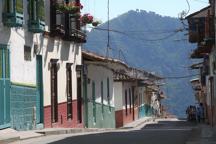
La première fois que j’ai entendu parler de la Colombie – comme destination touristique, j’entends –, c’était lors de notre voyage en Equateur au cours de notre hâlte à La Rana canto(que je recommande chaleureusement d’ailleurs pour qui voudrait faire un stop à la campagne. C’est vraiment très bien). Nadine et Pascal nous ont dit qu’ils commençaient à accueillir des backpackers venant de Colombie et que ces derniers trouvaient cela vraiment super.
Puis un podcast de Voyageurs du Monde m’a persuadée que la Colombie était le pays à visiter rapidement.
Ma fille (19 ans à l’époque) n’a pas été difficile à convaincre. Elle adore l’Amérique latine et une de ses meilleures amies a passé de nombreuses années en Colombie. Les garçons (mon tendre et cher, et notre fils - 17 ans) étaient loin d’être convaincus. Il faut dire que le site du ministère des affaires étrangères était tout sauf rassurant avec plein de rouge partout et un peu de jaune. Mais grâce à un travail de lobbying acharné et astucieux des filles, la promesse de bien rester dans les zones jaunes, ils ont fini par se laisser entraîner. (Entre notre décision et le voyage, le rouge du MAE a été largement réduit).
Restait à établir le parcours. La Colombie c’est grand, très grand. Et les routes sont lentes, très lentes. Pas question de vouloir trop en faire. Notre choix s’est porté sur la région du café, Medellin, Carthagène - parce que Carthagène a beau être très touristique, il nous paraissait difficilement envisageable de passer outre – et la Santander (avec Saint-Gil) que nous avons privilégié au parc de Tayrona (qui nous paraissait davantage semblable à ce que nous avions pu découvrir au cours de nos précédents voyages).
J’ai été guidée dans mes choix par les posts de Intothetrees -merci mille fois à lui- et le blog de Mars56 - merci aussi mille fois. Quelques blogs de voyageurs en tour du monde aussi (peu de sites évoquaient la Colombie à l’époque et j’ai découvert que les blogs de TDM étaient une bonne source d’information dans ce cas).
Pour optimiser les trajets, j’ai choisi une arrivée dans la région du café et un départ de Bogota. Trouver les billets au meilleur prix a été un peu compliqué et j’ai dû me résoudre à passer par un site de grossiste, chose que je ne fais jamais, en croisant les doigts pour ne pas avoir de problèmes. Deux vols intérieurs (Medellin – Carthagène et Carthagène – Bucaramanga) ont permis d’alléger les trajets.
Pour les hôtels, je n’ai pas eu le temps de potasser et puis à vrai dire, il n’y avait pas vraiment de quoi potasser. Je les ai choisis quelques jours à l’avance sur Booking en fonction des différents commentaires. Bien m’en a pris : en réservant depuis l’étranger – et Booking fait partie de « réserver depuis l’étranger », même nous étions déjà en Colombie lors de la réservation – on ne paye pas la TVA.
Au final, le trajet a donné cela.
5 août : trajet Paris - Perreira 6 août : Trajet pour Salamina – Salamina 7 août : Salamina - Balade aux alentours 8 août : Salamina - San Felix-vallée de Samaria 9 août : en route pour Jardin de Antoquia 10 août : Jardin de Antoquia 11 août : Jardin de Antoquia 12 août : trajet pour Medellín - musée de Antoquia 13 août : Guatape 14 août : Medellín - Free tour- Metrocable et Comuna 13 15 août : trajet pour Carthagène - Carthagène 16 août : Carthagène 17 août : Carthagène – les îles de Rosaire 18 août : Carthagène – La Boquhttp://illa 19 août : En route pour San Gil. Non ! pour Bogota ! 20 août : San Gil 21 août : Barichara- Guane 22 août : Rafting à San Gil 23 août : San Gil- Guadalupe 24 août : Guadalupe 25 août : Trajet pour Bogotá 26 août : Bogotá – bike tour – La calendelaria- musée de l’or 27 août : Bogotá - Montserrat- retour sur Paris
Tant pis pour la carte que j'ai faite sur Google earth : je ne peux pas la télécharger, pas assez de pixels!!
Nous avons donc adopté un rythme cool, nous laissant le temps de la découverte mais aussi du repos entre des trajets qui ont été souvent chaotiques voire complétement chamboulés. J’y reviendrai.
Un petit bilan, avant de passer au détail du récit : nous avons tout quatre bien apprécié la Colombie et les Colombiens. Le très bon espagnol de notre fille nous a beaucoup aidé à la fois pour nous débrouiller – mais nous aurions pu faire sans – mais aussi pour échanger avec les gens, notamment dans le bus. Le Colombie est un pays vraiment très chouette et mon seul regret, partagé par au moins un autre membre de la famille (je vous laisse deviner lequel), est de ne pas avoir eu plus de temps pour, par exemple, aller à Mompox ou encore Mongi.
Quant à la sécurité, souvent source d’interrogations, jamais nous ne nous sommes sentis menacés. Bien sûr nous avons pris les précautions d’usage et, dans les villes, Medellín et Bogotá, j’avais choisi pour nous loger les quartiers les plus sécures, peut-être moins typiques mais plus simples à gérer. Evidemment, cela ne veut pas dire qu’il n’y pas de problèmes, mais nous n’avons pas eu de soucis pour voyager. Dans la région du café, nous avons croisé maints militaires dûment armés, un peu impressionnant quand même.
La première fois que j’ai entendu parler de la Colombie – comme destination touristique, j’entends –, c’était lors de notre voyage en Equateur au cours de notre hâlte à La Rana canto(que je recommande chaleureusement d’ailleurs pour qui voudrait faire un stop à la campagne. C’est vraiment très bien). Nadine et Pascal nous ont dit qu’ils commençaient à accueillir des backpackers venant de Colombie et que ces derniers trouvaient cela vraiment super.
Puis un podcast de Voyageurs du Monde m’a persuadée que la Colombie était le pays à visiter rapidement.
Ma fille (19 ans à l’époque) n’a pas été difficile à convaincre. Elle adore l’Amérique latine et une de ses meilleures amies a passé de nombreuses années en Colombie. Les garçons (mon tendre et cher, et notre fils - 17 ans) étaient loin d’être convaincus. Il faut dire que le site du ministère des affaires étrangères était tout sauf rassurant avec plein de rouge partout et un peu de jaune. Mais grâce à un travail de lobbying acharné et astucieux des filles, la promesse de bien rester dans les zones jaunes, ils ont fini par se laisser entraîner. (Entre notre décision et le voyage, le rouge du MAE a été largement réduit).
Restait à établir le parcours. La Colombie c’est grand, très grand. Et les routes sont lentes, très lentes. Pas question de vouloir trop en faire. Notre choix s’est porté sur la région du café, Medellin, Carthagène - parce que Carthagène a beau être très touristique, il nous paraissait difficilement envisageable de passer outre – et la Santander (avec Saint-Gil) que nous avons privilégié au parc de Tayrona (qui nous paraissait davantage semblable à ce que nous avions pu découvrir au cours de nos précédents voyages).
J’ai été guidée dans mes choix par les posts de Intothetrees -merci mille fois à lui- et le blog de Mars56 - merci aussi mille fois. Quelques blogs de voyageurs en tour du monde aussi (peu de sites évoquaient la Colombie à l’époque et j’ai découvert que les blogs de TDM étaient une bonne source d’information dans ce cas).
Pour optimiser les trajets, j’ai choisi une arrivée dans la région du café et un départ de Bogota. Trouver les billets au meilleur prix a été un peu compliqué et j’ai dû me résoudre à passer par un site de grossiste, chose que je ne fais jamais, en croisant les doigts pour ne pas avoir de problèmes. Deux vols intérieurs (Medellin – Carthagène et Carthagène – Bucaramanga) ont permis d’alléger les trajets.
Pour les hôtels, je n’ai pas eu le temps de potasser et puis à vrai dire, il n’y avait pas vraiment de quoi potasser. Je les ai choisis quelques jours à l’avance sur Booking en fonction des différents commentaires. Bien m’en a pris : en réservant depuis l’étranger – et Booking fait partie de « réserver depuis l’étranger », même nous étions déjà en Colombie lors de la réservation – on ne paye pas la TVA.
Au final, le trajet a donné cela.
5 août : trajet Paris - Perreira 6 août : Trajet pour Salamina – Salamina 7 août : Salamina - Balade aux alentours 8 août : Salamina - San Felix-vallée de Samaria 9 août : en route pour Jardin de Antoquia 10 août : Jardin de Antoquia 11 août : Jardin de Antoquia 12 août : trajet pour Medellín - musée de Antoquia 13 août : Guatape 14 août : Medellín - Free tour- Metrocable et Comuna 13 15 août : trajet pour Carthagène - Carthagène 16 août : Carthagène 17 août : Carthagène – les îles de Rosaire 18 août : Carthagène – La Boquhttp://illa 19 août : En route pour San Gil. Non ! pour Bogota ! 20 août : San Gil 21 août : Barichara- Guane 22 août : Rafting à San Gil 23 août : San Gil- Guadalupe 24 août : Guadalupe 25 août : Trajet pour Bogotá 26 août : Bogotá – bike tour – La calendelaria- musée de l’or 27 août : Bogotá - Montserrat- retour sur Paris
Tant pis pour la carte que j'ai faite sur Google earth : je ne peux pas la télécharger, pas assez de pixels!!
Nous avons donc adopté un rythme cool, nous laissant le temps de la découverte mais aussi du repos entre des trajets qui ont été souvent chaotiques voire complétement chamboulés. J’y reviendrai.
Un petit bilan, avant de passer au détail du récit : nous avons tout quatre bien apprécié la Colombie et les Colombiens. Le très bon espagnol de notre fille nous a beaucoup aidé à la fois pour nous débrouiller – mais nous aurions pu faire sans – mais aussi pour échanger avec les gens, notamment dans le bus. Le Colombie est un pays vraiment très chouette et mon seul regret, partagé par au moins un autre membre de la famille (je vous laisse deviner lequel), est de ne pas avoir eu plus de temps pour, par exemple, aller à Mompox ou encore Mongi.
Quant à la sécurité, souvent source d’interrogations, jamais nous ne nous sommes sentis menacés. Bien sûr nous avons pris les précautions d’usage et, dans les villes, Medellín et Bogotá, j’avais choisi pour nous loger les quartiers les plus sécures, peut-être moins typiques mais plus simples à gérer. Evidemment, cela ne veut pas dire qu’il n’y pas de problèmes, mais nous n’avons pas eu de soucis pour voyager. Dans la région du café, nous avons croisé maints militaires dûment armés, un peu impressionnant quand même.
Toilettes dans le train pour Manakara (Madagascar) English translation pending
Bonsoir,
Étant sensible des intestins, je me demande si dans le train qui relie Manakara a des toilettes convenables?
Merci d avance
Étant sensible des intestins, je me demande si dans le train qui relie Manakara a des toilettes convenables?
Merci d avance
Compte rendu de 3 semaines en Colombie, novembre 2019 English translation pending
Bonjour à tous,
Si cela peut aider certains dans l’élaboration de leur voyage, voici un ci-dessous un descriptif de mon voyage que je viens de faire du 19 novembre au 10 décembre.
j’ai mentionné quelques prix (sachant que la haute saison démarre vers la 2eme semaine de décembre, vous aurez peut-être quelques hausses de tarifs comme à Tayrona si vous y allez après).
19 nov, arrivée Bogota vers 14h30, sorti avec bagages et passeport vers 15h30, je suis allé directement à la gare des bus (taxi 20 000 cop) pour prendre un bus vers Tunja (22 000cop). Attention de Bogota vers Tunja il y a des grands minibus de 20 places environ qui vont s’arreter tout le long de la route (+45min environ comme j’ai subit) et d’autres bus plus grand, plus confort et plus rapide. (souvent on prend au hasard car differentes compagnies). Arrivée vers 19H30 à Tunja j’étais invité en couchsurfing. 2eme jour, petit tour en ville à Tunja (rien d’exceptionnel à voir, un petit tour sur la place…) puis nous sommes allées en voiture à Villa de Leyva (45 à 60min de route) pour y passer quelques heures. Petite ville sympa avec sa place, son église… Cela peut être bien d’y passer une nuit comme font beaucoup de touristes. 3eme jour, bus de Tunja vers San Gil le matin (40 000cop) (si vous dormez à Villa de Leyva, vous serez obligé de prendre 2 bus, le 1er étant pour revenir à Tunja). San Gil, pas grand-chose à faire dans la ville, c’est plutôt un camp de base pour les excursions aux alentour. 4eme jour, bus vers Barrichara (1h, 5200cop), visite de la petite ville puis rando vers Guane (3h environ, facile car plat et descente sur un sentier dans la nature), retour en bus de Guane à San Gil (7 000 cop). 5eme jour, rafting le matin sur rio suarez (170 000cop, tres bonne activité, bonnes sensations). Le soir départ en bus de nuit vers Santa Marta, 70 000cop, de 19H à 8h du matin 6eme jour, arrivée le matin vers 8h à Santa Marta, plongée sous-marine l’après-midi (la visibilité et l’intérêt est moyen, mais le prix est correct, 200 000 cop les 2 plongées, 13H à 16h30) 7eme jour, depart pour le parc Tayrona en bus (1h, 6 000cop), entrée du parc calabrazo comme peu le font (53 000 + 3 000 cop par jour dans le parc pour leur assurance obligatoire) = cela commence par une grosse montée environ 1H30/2h jusqu’à pueblito (malheureusement fermé en ce moment) puis 1H30 de descente vers la plage naturiste et à coté cabo san juan. Malgré les avis qui disaient plage surchargée, beaucoup de bruit, j’ai trouvé cela tout a fait bien, pas de nuisances particulières, les prix de la restauration sont correctes (20 à 30 000 cop le plat). Nuit en hamac 40 000 cop. 8eme jour, fin de rando du parc vers l’entrée Zaino, quasi tout plat, environ 2H30/3h. tres fréquenté. (le sentier de la vieille est beaucoup plus nature et moins fréquenté, mais il faut aimer marcher car plus dur). Bus vers palomino (1h, 6 000cop). 9eme jour, rien de spécial à Palomino, ville en plein développement, rues en terre donc un peu sale, l’activité principale est de descendre une rivière calme sur une grosse bouée pendant 1H30/2h (pas testé). Bus vers santa marta (2H, 10 000cop) 10 eme jour, le matin bus vers cartagene (44 000cop) et visite de la ville, château san felipe (25 000cop) 11eme jour, free guided tour et tranquille dans la ville (je n’ai pas voulu faire une journée plage car j’ai entendu des avis mitigés = plages jolies, parfois surchargés et vendeurs trop insistants), 12eme jour, bus vers l’aeroport (2 400cop)et avion vers Medellin puis taxi vers le centre. 13eme jour, free guided tour de la comuna 13, visite du centre-ville et de la colline cerro nutibara. 14eme jour, excursion rocher (18 000 cop) et guatape, environ 2H à l’aller puis au retour (15 000 cop par trajet) 15eme jour, bus vers jardin (29 000 cop), et petite rando dans l’après-midi 16eme jour, rando cueva del esplanador avec la cascade (soit le faire sans guide environ 6H de marche au total, soit pour 55 000cop avec un guide, aller et retour en jeep et entrée cascade incluse) ou bien taxi 20 000 à partager + entree cascade 20 000 + le retour, soit 3h à pied ou bien encore un taxi 17eme jour, journée bus vers salento (20 000 + 32 000 cop)(bus de jardin à riosciuto 8h à 11H30 puis vers salento de 12H15 à 16H30/17H environ) 18eme jour, rando cocoroa, transport en jeep depuis la place (3500 ou 4000cop je ne sais plus, par personne par trajet, 20min environ), puis rando (il faut payer 2 taxes de passage, environ 3 000 cop par entrée) (je conseille d’aller au bout du chemin et de ne pas prendre le 1er portail bleu afin de démarrer plus loin par la vallée des palmiers afin de bénéficier d’une meilleure visibilité sur les palmiers car cela se couvre vite donc la boucle en commençant par la colline puis redescente par la foret. On m’avait dit 4h ou 5H, j’ai mis 2H50 au total (je n’ai pas fait la rallonge de la maison du colibri car beaucoup de personnes n’y trouvent rien de spécial). Ensuite l’après-midi, je suis allé voir une maison production de café, tour guidée d’une heure (20 000 cop), prendre une jeep aussi depuis la place (3 000 par trajet par personne) 19eme jour, excursion en VTT (170 000cop), départ à 8H fin vers 14H, on met les vélos à l’arrière de la jeep, la jeep nous monte en haut et on fait uniquement de la descente donc rien de bien compliqué. Il y a un extra avec le parcours extrême possible pour 50 000 de plus et le niveau de difficulté augmente sensiblement. 20eme jour, bus vers pereira 1H (8 000cop) + taxi ou uber de pereira a bus a l’aéroport (10 000 cop), puis avion vers bogota, puis uber vers le centre. Visite de la ville l’après-midi musée de l’or, églises… 21eme jour colline de monserrate, prendre téléphérique 21000cop aller-retour, on peut faire le sentier à pied le dimanche, mais déconseillé en semaine (mauvaise fréquentation) puis visite du reste du centre-ville avec musée botero….
mon avis Tunja, rien de spécial, ville assez grande Villa de Leyva, petite ville sympa à voir 1 jour maxi San Gil, rien de special, camp de base idéal pour 2 nuits (un jour Barrichara Guane et un jour activité sportive rafting ou parapente…) Santa Marta, rien de special Tayrona, rando sympa et tres belle plage Palomino, petite ville calme, rien de special Cartagene, j’ai bien aimé la vieille ville meme si il y a trop de vendeurs qui viennent vers nous Medellin, tour à la comuna 13 sympa, centre-ville bof Guatape, tres joli comme excursion Jardin, petite ville sympa et nombreuses rando à faire, excursion cheval possible Salento, petite ville sympa et rando à faire, visite de ferme café, cheval ou vtt possibile…. Bogota, grande ville donc un peu moyen, colline monserrate à faire avec jolie vue, musée de l’or et botero sympa
au niveau de la durée dans chaque ville, sur 3 semaines, c’était parfait pour moi, ni trop ni pas assez belle météo, souvent soleil, forte chaleur entre santa marta et cartagene, seulement ½ journée de pluie à salento puis bogota
19 nov, arrivée Bogota vers 14h30, sorti avec bagages et passeport vers 15h30, je suis allé directement à la gare des bus (taxi 20 000 cop) pour prendre un bus vers Tunja (22 000cop). Attention de Bogota vers Tunja il y a des grands minibus de 20 places environ qui vont s’arreter tout le long de la route (+45min environ comme j’ai subit) et d’autres bus plus grand, plus confort et plus rapide. (souvent on prend au hasard car differentes compagnies). Arrivée vers 19H30 à Tunja j’étais invité en couchsurfing. 2eme jour, petit tour en ville à Tunja (rien d’exceptionnel à voir, un petit tour sur la place…) puis nous sommes allées en voiture à Villa de Leyva (45 à 60min de route) pour y passer quelques heures. Petite ville sympa avec sa place, son église… Cela peut être bien d’y passer une nuit comme font beaucoup de touristes. 3eme jour, bus de Tunja vers San Gil le matin (40 000cop) (si vous dormez à Villa de Leyva, vous serez obligé de prendre 2 bus, le 1er étant pour revenir à Tunja). San Gil, pas grand-chose à faire dans la ville, c’est plutôt un camp de base pour les excursions aux alentour. 4eme jour, bus vers Barrichara (1h, 5200cop), visite de la petite ville puis rando vers Guane (3h environ, facile car plat et descente sur un sentier dans la nature), retour en bus de Guane à San Gil (7 000 cop). 5eme jour, rafting le matin sur rio suarez (170 000cop, tres bonne activité, bonnes sensations). Le soir départ en bus de nuit vers Santa Marta, 70 000cop, de 19H à 8h du matin 6eme jour, arrivée le matin vers 8h à Santa Marta, plongée sous-marine l’après-midi (la visibilité et l’intérêt est moyen, mais le prix est correct, 200 000 cop les 2 plongées, 13H à 16h30) 7eme jour, depart pour le parc Tayrona en bus (1h, 6 000cop), entrée du parc calabrazo comme peu le font (53 000 + 3 000 cop par jour dans le parc pour leur assurance obligatoire) = cela commence par une grosse montée environ 1H30/2h jusqu’à pueblito (malheureusement fermé en ce moment) puis 1H30 de descente vers la plage naturiste et à coté cabo san juan. Malgré les avis qui disaient plage surchargée, beaucoup de bruit, j’ai trouvé cela tout a fait bien, pas de nuisances particulières, les prix de la restauration sont correctes (20 à 30 000 cop le plat). Nuit en hamac 40 000 cop. 8eme jour, fin de rando du parc vers l’entrée Zaino, quasi tout plat, environ 2H30/3h. tres fréquenté. (le sentier de la vieille est beaucoup plus nature et moins fréquenté, mais il faut aimer marcher car plus dur). Bus vers palomino (1h, 6 000cop). 9eme jour, rien de spécial à Palomino, ville en plein développement, rues en terre donc un peu sale, l’activité principale est de descendre une rivière calme sur une grosse bouée pendant 1H30/2h (pas testé). Bus vers santa marta (2H, 10 000cop) 10 eme jour, le matin bus vers cartagene (44 000cop) et visite de la ville, château san felipe (25 000cop) 11eme jour, free guided tour et tranquille dans la ville (je n’ai pas voulu faire une journée plage car j’ai entendu des avis mitigés = plages jolies, parfois surchargés et vendeurs trop insistants), 12eme jour, bus vers l’aeroport (2 400cop)et avion vers Medellin puis taxi vers le centre. 13eme jour, free guided tour de la comuna 13, visite du centre-ville et de la colline cerro nutibara. 14eme jour, excursion rocher (18 000 cop) et guatape, environ 2H à l’aller puis au retour (15 000 cop par trajet) 15eme jour, bus vers jardin (29 000 cop), et petite rando dans l’après-midi 16eme jour, rando cueva del esplanador avec la cascade (soit le faire sans guide environ 6H de marche au total, soit pour 55 000cop avec un guide, aller et retour en jeep et entrée cascade incluse) ou bien taxi 20 000 à partager + entree cascade 20 000 + le retour, soit 3h à pied ou bien encore un taxi 17eme jour, journée bus vers salento (20 000 + 32 000 cop)(bus de jardin à riosciuto 8h à 11H30 puis vers salento de 12H15 à 16H30/17H environ) 18eme jour, rando cocoroa, transport en jeep depuis la place (3500 ou 4000cop je ne sais plus, par personne par trajet, 20min environ), puis rando (il faut payer 2 taxes de passage, environ 3 000 cop par entrée) (je conseille d’aller au bout du chemin et de ne pas prendre le 1er portail bleu afin de démarrer plus loin par la vallée des palmiers afin de bénéficier d’une meilleure visibilité sur les palmiers car cela se couvre vite donc la boucle en commençant par la colline puis redescente par la foret. On m’avait dit 4h ou 5H, j’ai mis 2H50 au total (je n’ai pas fait la rallonge de la maison du colibri car beaucoup de personnes n’y trouvent rien de spécial). Ensuite l’après-midi, je suis allé voir une maison production de café, tour guidée d’une heure (20 000 cop), prendre une jeep aussi depuis la place (3 000 par trajet par personne) 19eme jour, excursion en VTT (170 000cop), départ à 8H fin vers 14H, on met les vélos à l’arrière de la jeep, la jeep nous monte en haut et on fait uniquement de la descente donc rien de bien compliqué. Il y a un extra avec le parcours extrême possible pour 50 000 de plus et le niveau de difficulté augmente sensiblement. 20eme jour, bus vers pereira 1H (8 000cop) + taxi ou uber de pereira a bus a l’aéroport (10 000 cop), puis avion vers bogota, puis uber vers le centre. Visite de la ville l’après-midi musée de l’or, églises… 21eme jour colline de monserrate, prendre téléphérique 21000cop aller-retour, on peut faire le sentier à pied le dimanche, mais déconseillé en semaine (mauvaise fréquentation) puis visite du reste du centre-ville avec musée botero….
mon avis Tunja, rien de spécial, ville assez grande Villa de Leyva, petite ville sympa à voir 1 jour maxi San Gil, rien de special, camp de base idéal pour 2 nuits (un jour Barrichara Guane et un jour activité sportive rafting ou parapente…) Santa Marta, rien de special Tayrona, rando sympa et tres belle plage Palomino, petite ville calme, rien de special Cartagene, j’ai bien aimé la vieille ville meme si il y a trop de vendeurs qui viennent vers nous Medellin, tour à la comuna 13 sympa, centre-ville bof Guatape, tres joli comme excursion Jardin, petite ville sympa et nombreuses rando à faire, excursion cheval possible Salento, petite ville sympa et rando à faire, visite de ferme café, cheval ou vtt possibile…. Bogota, grande ville donc un peu moyen, colline monserrate à faire avec jolie vue, musée de l’or et botero sympa
au niveau de la durée dans chaque ville, sur 3 semaines, c’était parfait pour moi, ni trop ni pas assez belle météo, souvent soleil, forte chaleur entre santa marta et cartagene, seulement ½ journée de pluie à salento puis bogota
Two weeks with a friend in southern Kazakhstan
Hello everyone!
I’m back from two weeks in southern Kazakhstan. I went with a friend, and we organized everything ourselves. We came back enchanted by this trip: stunning landscapes, lots of animals seen in the parks, and above all, top-notch hospitality and welcome... All of this makes me really want to go back and explore the other countries in the region. In the meantime, I’m sharing the story of these two weeks of travel... Don’t hesitate if you have any questions. And if you want more practical info and/or see more photos, you can check out my blog: https://smilingaroundtheworld.com/category/kazakhstan/
Day 1: First Kazakh steps in Shymkent
So here we are in Kazakhstan for two weeks. We had an excellent flight with Air Astana, which instantly made it into my top 3 best airlines! From the airport, the service was top-notch, with very friendly staff who went out of their way to ensure we both got vegetarian meals (my order hadn’t been taken into account when booking the tickets online). The flight to Nur-Sultan (the new name for the capital, formerly Astana, renamed last month in honor of the resigning president) was three-quarters empty, and we each got to stretch out over three seats. We were given an incredible travel kit, including a reversible sleep mask with phosphorescent writing: “Do not disturb” or “Wake me for meals.” Awesome! As for the lighting in the plane, I think the interior cycled through every color to simulate evening, early night, pitch-black night, and then dawn. It was even a bit surreal—those lights and everyone’s glowing masks ^^ The flight was a bit early and too short for us to sleep well, but it was still pleasant :-)
Upon arriving in Nur-Sultan, the atmosphere was a bit colder. There was staff everywhere, and we were under heavy surveillance. A camera even filmed us as we entered the terminal. We got our passports stamped and settled in to wait for our second flight. We eventually realized we were waiting in the wrong place... We were still in the international terminal, while our next flight was domestic. We finally found the right spot—saved! We started our trip in Shymkent, in the south of the country. We dropped our bags at the City Hostel, a super modern youth hostel offering double rooms. The decor is industrial-style, with very high ceilings—we loved it. When we arrived, it was too early for check-in, so we just left our luggage and went for a walk around the neighborhood. There was quite a bit of traffic, and the avenues were very wide. Despite that, there was also a lot of greenery and green spaces, which lightened things up a bit.
We had lunch (pizza + smoothie) on the top floor of a shopping mall, then headed to the pre-Russian quarter, a much quieter area with its little streets and individual houses.
Back at the hostel, after checking in, we treated ourselves to a two-hour nap—it felt great! In the late afternoon, we set out to find the Salman Bazaar. It wasn’t easy to organize—we realized Shymkent isn’t a very touristy destination—but we eventually managed with the help of the hostel receptionist, who called us a taxi. This bazaar is huge and has everything you could need for daily life: clothes, food, household products, toys... We did some shopping for dinner, then took another taxi to Independence Park, inaugurated in 2011 for the 20th anniversary of Kazakhstan’s independence. We really liked this park—it’s very wooded, and the late afternoon light was, as always, beautiful and pleasant... In the center, a large monument resembles the center of a yurt.
We then walked back to the hostel via Independence Square and several parks. We wanted to grab a drink along the way but didn’t find anything inspiring—oh well. We had dinner at the hostel and went straight to bed. Tomorrow, we’re getting up early... We’re heading out for two days to explore Aksou-Jabagly National Park. This park is famous for its landscapes at this time of year—it should be in full bloom, especially with tulips. We’ll see!
Days 2 & 3: Canyon, tulips, and wildlife in Aksou-Jabagly Park
Located two hours from Shymkent, Aksou-Jabagly Park is reputed to be one of the most beautiful in the region. We took a taxi from Shymkent, and upon arrival, we were warmly welcomed by Ruslan and his mother. They live at the entrance to the reserve, at the foot of the mountains, in a house surrounded by poplars. The setting is exceptional, and we immediately fell in love with the place. For our first day, we set off to explore the Aksou Canyon. Ruslan arranged a 4x4 with a driver and a ranger. The ranger speaks a few words of English, and with Coralie’s few words of Russian, we should manage! After a “viewpoint” stop, the road turns into a dirt track. It’s rained a lot lately, and the track is sometimes very muddy—at one point, we even had to cross a river. Four-wheel drive was definitely needed! The ranger pointed out some marmots by the side of the path—they were adorable.
We finally arrived at “Inspector’s House No. 1,” which overlooks the canyon. The view is magnificent, with high cliffs, wildflowers, conifers, and the Aksou River winding far below. While the driver chatted with the inspector, we descended to the bottom of the canyon with the ranger. The tulips I’d been hoping for were there—I was so happy! There were red, yellow, and even bicolor ones...
At the bottom of the canyon, we took a little break by the river. “Aksou” means “white waters” in Kazakh—the water does indeed have a very special color, a blue that’s both very light and very intense, like some South American lagoons. It bubbles around the rocks. The climb back up was easier than we feared. Once at the top, we continued along the canyon. The perspective changed as we progressed, and we never got tired of the view... Eagles circled above us.
After about 2 km, the driver picked us up, and we continued to a small kiosk at the foot of the mountains, where we had a picnic. Ruslan’s mother had prepared vegetarian “lunch boxes”—it was delicious and felt good to eat. However, it had gotten noticeably colder, so we put our jackets and scarves back on! After the meal, the driver walked off with a bucket—we figured he was going mushroom picking with Inspector No. 2, who had a house nearby.
We enjoyed the spot a bit longer while the driver gathered mushrooms, and then we headed back toward Ruslan’s place. Or so we thought... The return trip turned out to be quite long—the park wasn’t as deserted as it seemed, and the driver stopped every five minutes to chat with people we passed. At one point, we ran into Inspector No. 2 on horseback—it looked like there was a problem with a car further ahead... The driver and ranger bolted out of the car, headed toward the other vehicle, and we heard raised voices... When they came back, we tried to figure out what had happened, but no luck. We stopped again at Inspector No. 1’s house (are you following?), and they made us get out, telling us Inspector No. 2 needed the car for a few minutes... They left us stranded with Inspector No. 1, who went home, leaving us in the garden :-D We kept busy with the puppies, and I even took a little nap in the sun... Three-quarters of an hour later, we finally left—we didn’t fully understand what happened and never found out!
We got back (almost) without stopping to Ruslan’s house. Our room was ready, and we settled in quickly before dinner. It was already 6:30 PM, even though we were supposed to be back by 4 PM. Mushroom picking really slows things down ^^ Ruslan’s mother had prepared a delicious meal: vegetable soup, raw vegetable salad, and a mushroom, carrot, and potato stew. We loved it!
We spent the rest of the evening planning the rest of our trip while sipping tea. At one point, Ruslan and his mother signaled that there were wild boars right across from us—we could see them clearly! There were three adults and three piglets. We also took a little walk in the garden, watched the sunset, I did some blogging, and Coralie read... A lovely evening, and an equally lovely ten-hour night! The next morning, after a good breakfast, we set off on foot into the park. The trail starts right next to Ruslan’s house—so convenient! Today, we were with another ranger, two Germans (brother and sister), and their English-speaking guide (who didn’t guide much). We walked on a dirt road—there were even more tulips than yesterday, and the snow-capped mountains in the distance were stunning. After 5 km, we reached a small cabin, then continued another kilometer to Kishy Kaindy, a viewpoint overlooking the Jabagly River waterfalls (Jabagly means “year-old foal”). It was spectacular! We stayed a good while admiring this natural wonder. Like yesterday, the ranger didn’t rush us at all—it was really nice. We also saw eagles and an ibex perched on a ridge.
We had a picnic at the cabin before heading back the same way we came. This time, the snow-capped peaks were facing us—so beautiful! We picked up our bags and said goodbye to Ruslan’s mother. She was really happy today because her granddaughter was there. She told us she was a “babushka”—I understood that! Ruslan then drove us to Turar Ryskulov, where we took a shared taxi back to Shymkent.
In Shymkent, we struggled a bit with our Airbnb. We waited half an hour for the person who was supposed to let us in, then discovered the Wi-Fi wasn’t working—but we had a lot of bookings to make that evening. The lady finally lent us a Kazakh SIM card with data, which Coralie put in her phone in “hotspot” mode so I could get some internet too. All of that took nearly two hours. Phew! We then rushed to do some shopping at the supermarket. On the way back, some lights caught my eye—it was a pedestrian street all decorated with a funfair next to it. It was very lively, and we spent a good while strolling and people-watching! The rest of our evening was studious, between preparing dinner and booking our next stops.
Day 4: Turkestan, Yasawi Mausoleum, and Sauran ruins
This morning, after one last stroll in Shymkent, we headed to Turkestan. When we arrived at the bus station, we were told the next bus was in nearly three hours, but there were minibuses leaving when full. The system was well-oiled, and in just fifteen minutes, our minibus was ready to go. We each had a seat (and one for our luggage since there’s no trunk!), and the minibus was quite new—nothing like Madagascar ;-)
The trip went well despite a few driving scares—the driver was going a bit fast for my liking! Along the road, the fields were full of poppies—so pretty. When we arrived, we headed straight to the Edem hotel, where we wouldn’t be staying (we had a train to Almaty at midnight) but where we wanted to leave our luggage for the day. They agreed easily—great! Once we’d dropped off our bags and suitcases, we started our visits.
We began with the architectural gem and largest pilgrimage site in Kazakhstan: the mausoleum of Khodja Ahmad Yasawi, a great Sufi sage. Yasawi’s original tomb was already a pilgrimage site when Tamerlane ordered the construction of a larger mausoleum in 1390. It’s decorated with white and blue tiles and has a turquoise dome (currently under renovation). The main facade, unfinished at Tamerlane’s death, was left in earth with visible scaffolding. Impressive! The site is UNESCO-listed. Inside, the main hall displays a large cauldron, and other small rooms showcase plates, ancient coins, belts... Yasawi’s tomb is visible via two adjacent corridors.
We then strolled through the park, which includes many other mausoleums and tombs. We visited the old baths, the Friday Mosque, and then the history museum. The underground mosque, where Yasawi’s cell is located (where he retreated at the end of his life), was unfortunately closed for renovations.
We then went back to the Edem hotel to have them call us a taxi, and we set off to visit the ancient fortress of Sauran. This Silk Road city, once prosperous, is now reduced to ruins, with thousands of poppies blooming between them. High walls once surrounded a bustling and pleasant city. Many foundations remain visible. The place is vast, quiet, almost deserted, and imbued with a certain melancholy... The deep red poppies swayed in the wind, between the remnants of this city, reminding us how fleeting things are.
Back in Turkestan, we had dinner at the Edem hotel’s restaurant (we had to thank them somehow ;-)) and then rushed to the station to catch our train... 18 hours of travel awaited us to Almaty!
Day 5: From Turkestan to Almaty, 18 hours by train across the Kazakh steppe
We traveled from Turkestan to Almaty by train. We booked our tickets the day before departure, and only six seats were left: three in second class, not together at all, and three in first class, also not together but in the same carriage. We opted for first class! It was more expensive, but for such a long trip, a little comfort wouldn’t hurt... We wondered if we’d manage to switch cabins to be together, but it resolved itself: when we boarded, the conductor/carriage chief immediately noticed we weren’t together. He literally kicked a young man out of his berth so we could travel in the same cabin. We felt bad for the young man, even though he seemed to take it well... we thanked him with dried fruit (and I can confirm he took it well—the next day, he came to chat with us). In any case, we were really happy to have our own little cabin for this long journey, especially since we were the only foreigners and the only women in the carriage.
Eighteen hours by train might seem long, but these long trips while traveling aren’t wasted time—they’re the breathing space of the journey. They’re the essential moments for digesting what we’ve already experienced and preparing for future discoveries. They’re also privileged moments for reflection. Traveling slowly, to the rhythm of the train, means falling asleep in Turkestan’s outskirts, lulled by the train’s rocking and creaking, and waking up in the steppe. It’s feeling the train slow down and stop, stepping onto the platform for a moment, and watching the women sell food to passengers. It’s taking the time to write, read, think. It’s chatting with our neighbors and, despite the language barrier, managing to communicate a little. It’s picnicking at the little table in our cabin, with the landscape rolling by outside, and listening to music. It’s feeling privileged, imagining ourselves on the Orient Express or the Trans-Siberian. Reminding ourselves that one day, one day for real, we’ll take that Trans-Siberian. And smiling, thinking that in the meantime, in a few months, there’ll be the Trans-Canadian...
Days 6 & 7: Almaty, the “little apple”
The former capital of Kazakhstan, Almaty is known as the most Western and lively city in the country. At first, we had a bit of trouble identifying the city center—it’s more spread out and less dense than what we’re used to in Europe—but once we got our bearings, we really enjoyed strolling along the wide avenues lined with cafés and in the few pedestrian streets. The city’s emblem is the apple, which you’ll find in various forms around the city, from benches to statues to fountains. The original apple, from which all the apples we know today descend, is said to come from the mountains of Kazakhstan.
For nature, Almaty is a pretty green city. It has large parks, like Panfilov Park, which houses the Zenkov Cathedral. Some streets are also very tree-lined, so much so that they almost look like gardens. Often, high mountains peek out from behind the streets...
For shopping, traditional boutiques sit alongside big international brands. We really liked the Green Bazaar, a large market that sells everything. The food section was great, with stalls of pickled vegetables, dried fruits, and beautifully stacked fresh fruits... A feast for the eyes and lots of temptations for me!
For culture, Almaty has several museums. We visited two: the Fine Arts Museum and the National Museum. Both are housed in very Soviet-looking buildings on the outside, but the Fine Arts Museum turned out to be quite modern inside, with a pleasant museography. The National Museum, on the other hand, has stayed true to its roots ^^ Just walking through it was an experience in itself. And we did quite a bit of shopping there... The hall is a giant shop with lots of handicrafts—we treated ourselves.
The Arasan Baths are a must in Almaty. They’re said to be among the most beautiful baths in Central Asia... Architecturally, I didn’t find them amazing (nothing like Budapest’s, for example), but wow, did it feel good to relax there after a day of sightseeing! I happily moved between the sauna, hammam, and Russian sauna, with a preference for the latter—less dry than a traditional sauna and less humid than the hammam. You can buy bundles of leaves to slap yourself (or get slapped) with to boost circulation. The prices are very affordable too... On a weekday evening, we paid 1,800 tenge, or 4.5 euros, for an hour. Note that they add 20 minutes for changing, so you really get a full hour in the baths.
For restaurants, we didn’t try many because we preferred to limit our food budget by cooking ourselves. However, we did try and highly recommend Daredzhani, a great Georgian restaurant where we feasted. We didn’t know Georgian cuisine before, but we really liked it—vegetables cooked in various ways, cheese-filled breads, potato and/or egg-filled breads, and very thin fruit pastes made from grapes. We actually ate there twice because it was so good! We also loved Coffee Delia, where you can enjoy delicious pastries in a very cozy setting.
Besides being a pleasant place to live, Almaty is also a great base for exploring the surrounding area, and we were happy to stay eight days to discover more of the region!
Days 7, 8 & 9: Getting green around Almaty: Kok Tobe, Shymbulak, Medeo, and Big Almaty Lake
During our stay in Almaty, we used a rather unusual means of transport several times: the cable car! Here, it’s called a "gondola," and it allowed us to gain some altitude and breathe in the fresh mountain air surrounding Almaty ;-)
First cable car ride: Kok Tobe. The cable car starts in the city center and takes you to the top of a hill overlooking Almaty. At the top, it’s fairground vibes with an upside-down house, a Ferris wheel, rides, and the inevitable eagle trainer... There’s even a little corner dedicated to the Beatles, complete with music and a statue!
Second ride: Shymbulak. This time, you take a bus to Medeo, then three cable cars to the top of the mountain, at 3,200 meters altitude. Shymbulak is the largest ski resort in Central Asia. We went there to hike, but there was still snow and skiers, so we settled for admiring the view... With the blue sky and sun we had, it was gorgeous! We then treated ourselves to tea on the terrace—chalet vibes... At Paul’s, we weren’t completely out of place ;-)
Before taking the bus back, we stopped by Medeo, where there’s a large ice rink. With 10,000 m², it can host a thousand skaters in winter! This season, it’s closed; part of it is used as a go-kart track, and the other as a landing strip for paragliders.
Located an hour’s drive from the city center, Big Almaty Lake reveals itself at the last moment, around a bend, nestled in a setting of mountains and greenery. With the recent cold snap, it’s frozen, and the edges are snowy—a beautiful winter atmosphere! The ice was starting to melt, though—we could hear the water moving underneath, and when Coralie tried to walk on the ice, it collapsed under her feet. Unfortunately, it’s impossible to walk around it—a ranger keeps an eye out and blocks the adventurous (including us ;-)).
Days 10 & 11: Excursions around Almaty: Charyn Canyon, Issyk, and Turgen
Almaty’s tourism office is very active and organizes outings on weekends and holidays. We went to Charyn Canyon and then to Issyk and Turgen. A great way to discover the Almaty area at a modest cost (the outing costs about 6,000 tenge, or 15 euros per person).
Formed over millennia by erosion and wind, Charyn Canyon is reminiscent of the Colorado and the Grand Canyon. The most touristy part we visited is called the Valley of Castles, referring to the rock formations that resemble towers. We first walked along the ridge, where there are many viewpoints, then descended into the canyon. A three-kilometer walk leads to the banks of the Charyn River. The place seems to be a favorite relaxation spot for Kazakh families, who picnic, play ball, sunbathe... There’s also a hotel, bungalows, yurts, and a restaurant. Issyk is famous for its burial mounds and its Golden Man—maybe even a Golden Woman—found there. A small museum displays some artifacts. A little further on is Issyk Lake, once dried up but now reappearing... Whether naturally or not isn’t very clear!
As for Turgen, it’s a natural park known for its gorges and waterfalls. We didn’t have time to explore it in detail, but the bus drove through some beautiful landscapes, and we still walked to Bear Waterfall. It’s not incredible, but it’s still a nice little hike.
Besides the practical side of these organized excursions from Almaty, we appreciated being able to do an activity that Kazakhs do on weekends. During the Issyk/Turgen excursion, we really hit it off with Karina, a young student dragged there on vacation by her mother. She’s currently studying computer science at the best university in Astana and hopes to go to Europe eventually... A brilliant young woman, and a chance for us to chat in English ;-)
Days 12 & 13: The spectacular landscapes of Altyn-Emel Park
The last stop on our Kazakhstan trip was Altyn-Emel Park. This park is quite hard to access, so we opted for a car with a driver for two days—pure luxury!
Our driver’s name is Andrei. We met him at 7 AM outside our apartment on Wednesday morning. He doesn’t speak English, but a young man from the agency we booked through was also there, and we went over the itinerary together before leaving with Andrei.
Our first stop was Tamgaly Tas, two hours from Almaty. It’s a site where you can see 16th-century petroglyphs depicting Buddha. The place is also known for climbing—there were lots of young people harnessed up and/or climbing. It’s right in the middle of the Kazakh countryside, and we had a bit of trouble finding it!
Even with the language barrier, Andrei turned out to be very friendly. He suggested photo stops from time to time, didn’t rush us, and pointed out animals he saw... We even backed up on the road to see and help a tortoise cross!
It took another two and a half hours to reach Bashi, the “gateway” village to Altyn-Emel Park. After a quick stop at the rangers’, we arrived at the hotel. Our guidebook mentioned modest guesthouses, but things are changing... The hotel is large, brand new, and still being expanded. It reminded me of some Chinese hotels in Laos.
We had a quick lunch with Andrei—he explained that he’s a truck driver normally, delivering clothes and fabrics between Kazakhstan, Afghanistan, and Russia. He also showed us photos of his wife and son and told us he’s recently become a grandfather! We then headed to the park, grabbing a ranger on the way. Like in Aksou-Jabagly, he was dressed in full military gear. We first headed toward the Katutau Mountains. The rocks are reddish, sculpted by wind and erosion—the place reminded us a bit of Charyn Canyon. We had some “free time” to explore—we didn’t need to be told twice... Meanwhile, Andrei and the ranger chatted nonstop—it looked like they’d hit it off!
We got back in the car and continued along the track to the Aktau Mountains. Change of scenery! The mountains weren’t red anymore but white... Or so they appeared from afar. When we got closer, we realized they were actually multicolored, striped with yellow, pink, and ochre veins... It was magnificent, even more so with the late afternoon light. We had time to explore on our own again, and we walked with delight in this almost dreamlike landscape. We thought we’d made the right choice coming here ;-) We made one last stop before heading back to see a 700-year-old willow. It’s in an oasis where other tourists were camping—very tempting... I got the coordinates of their guide for next time ;-) The way back was in beautiful light, between sunset and a distant storm. Nature even treated us to a gorgeous sunset!
It was past 8 PM when we got back to the hotel, but our dinner was still waiting for us. We ate with Andrei, chatted a bit with a Polish woman who spoke both Russian and French (we put her to work chatting with Andrei ;-)), and then had a quiet evening with Wi-Fi, a shower, and reading in our room.
The next day, after breakfast, we met up with the same ranger and headed toward the singing dunes. These dunes are supposed to make a sound when you slide down their slopes. I was more than skeptical, but okay! When we arrived, we discovered a beautiful landscape—the main dune is gigantic, and when we reached the top, the view was extraordinary: it was the first time I’d seen a dune in the desert, snow-capped mountains, and a river all in one glance! A group of Chinese tourists was ahead of us on the dune, but they turned back quickly, and we were alone. After studying the terrain, I chose a slope that seemed good, and I started sliding down on my bottom... Quickly, I heard and felt a strong vibration, which turned into a hum. The dune really sings! It’s completely crazy... We did several tests—the most effective was sliding down side by side. But it works as long as there aren’t too many tourists doing it and the dune has time to rebuild between slides... There are about thirty singing dunes in the world. This phenomenon, already described by Marco Polo, comes from the synchronous movement of sand grains, which must be very round and covered with a varnish called “desert glaze”...
Covered in sand but delighted, we headed back to Bashi. The ranger stopped at a small spring so we could wash up, but it was almost dry. Along the way, we also saw the “Oshaktas,” a place where Genghis Khan’s expedition is said to have camped in 1219 during his conquest of Central Asia. The stones were apparently used to support the cauldron where food was prepared. A little further on, the ranger made us stop: there were antelopes!!! We saw one up close and a herd further away.
When we got back to the hotel, I took a quick shower to get rid of the sand—I felt like I had it everywhere! We had a quick lunch and then hit the road back to Almaty. Andrei drove very well, had a nice playlist, and I let myself be lulled while watching the landscape roll by outside...
For our last night in Kazakhstan, we booked a yurt in the hills above Almaty, not far from Medeo. For one night, we pretended to be nomads... The bed was a bit hard, and the air was a bit chilly, but we loved it! And the welcome was kind, the meal very good—only downside: the horse milk and camel milk, still warm... I almost threw up. Well, it was an experience, and all of this beautifully concluded our Kazakh stay!
I’m back from two weeks in southern Kazakhstan. I went with a friend, and we organized everything ourselves. We came back enchanted by this trip: stunning landscapes, lots of animals seen in the parks, and above all, top-notch hospitality and welcome... All of this makes me really want to go back and explore the other countries in the region. In the meantime, I’m sharing the story of these two weeks of travel... Don’t hesitate if you have any questions. And if you want more practical info and/or see more photos, you can check out my blog: https://smilingaroundtheworld.com/category/kazakhstan/
Day 1: First Kazakh steps in Shymkent
So here we are in Kazakhstan for two weeks. We had an excellent flight with Air Astana, which instantly made it into my top 3 best airlines! From the airport, the service was top-notch, with very friendly staff who went out of their way to ensure we both got vegetarian meals (my order hadn’t been taken into account when booking the tickets online). The flight to Nur-Sultan (the new name for the capital, formerly Astana, renamed last month in honor of the resigning president) was three-quarters empty, and we each got to stretch out over three seats. We were given an incredible travel kit, including a reversible sleep mask with phosphorescent writing: “Do not disturb” or “Wake me for meals.” Awesome! As for the lighting in the plane, I think the interior cycled through every color to simulate evening, early night, pitch-black night, and then dawn. It was even a bit surreal—those lights and everyone’s glowing masks ^^ The flight was a bit early and too short for us to sleep well, but it was still pleasant :-)
Upon arriving in Nur-Sultan, the atmosphere was a bit colder. There was staff everywhere, and we were under heavy surveillance. A camera even filmed us as we entered the terminal. We got our passports stamped and settled in to wait for our second flight. We eventually realized we were waiting in the wrong place... We were still in the international terminal, while our next flight was domestic. We finally found the right spot—saved! We started our trip in Shymkent, in the south of the country. We dropped our bags at the City Hostel, a super modern youth hostel offering double rooms. The decor is industrial-style, with very high ceilings—we loved it. When we arrived, it was too early for check-in, so we just left our luggage and went for a walk around the neighborhood. There was quite a bit of traffic, and the avenues were very wide. Despite that, there was also a lot of greenery and green spaces, which lightened things up a bit.
We had lunch (pizza + smoothie) on the top floor of a shopping mall, then headed to the pre-Russian quarter, a much quieter area with its little streets and individual houses.
Back at the hostel, after checking in, we treated ourselves to a two-hour nap—it felt great! In the late afternoon, we set out to find the Salman Bazaar. It wasn’t easy to organize—we realized Shymkent isn’t a very touristy destination—but we eventually managed with the help of the hostel receptionist, who called us a taxi. This bazaar is huge and has everything you could need for daily life: clothes, food, household products, toys... We did some shopping for dinner, then took another taxi to Independence Park, inaugurated in 2011 for the 20th anniversary of Kazakhstan’s independence. We really liked this park—it’s very wooded, and the late afternoon light was, as always, beautiful and pleasant... In the center, a large monument resembles the center of a yurt.
We then walked back to the hostel via Independence Square and several parks. We wanted to grab a drink along the way but didn’t find anything inspiring—oh well. We had dinner at the hostel and went straight to bed. Tomorrow, we’re getting up early... We’re heading out for two days to explore Aksou-Jabagly National Park. This park is famous for its landscapes at this time of year—it should be in full bloom, especially with tulips. We’ll see!
Days 2 & 3: Canyon, tulips, and wildlife in Aksou-Jabagly Park
Located two hours from Shymkent, Aksou-Jabagly Park is reputed to be one of the most beautiful in the region. We took a taxi from Shymkent, and upon arrival, we were warmly welcomed by Ruslan and his mother. They live at the entrance to the reserve, at the foot of the mountains, in a house surrounded by poplars. The setting is exceptional, and we immediately fell in love with the place. For our first day, we set off to explore the Aksou Canyon. Ruslan arranged a 4x4 with a driver and a ranger. The ranger speaks a few words of English, and with Coralie’s few words of Russian, we should manage! After a “viewpoint” stop, the road turns into a dirt track. It’s rained a lot lately, and the track is sometimes very muddy—at one point, we even had to cross a river. Four-wheel drive was definitely needed! The ranger pointed out some marmots by the side of the path—they were adorable.
We finally arrived at “Inspector’s House No. 1,” which overlooks the canyon. The view is magnificent, with high cliffs, wildflowers, conifers, and the Aksou River winding far below. While the driver chatted with the inspector, we descended to the bottom of the canyon with the ranger. The tulips I’d been hoping for were there—I was so happy! There were red, yellow, and even bicolor ones...
At the bottom of the canyon, we took a little break by the river. “Aksou” means “white waters” in Kazakh—the water does indeed have a very special color, a blue that’s both very light and very intense, like some South American lagoons. It bubbles around the rocks. The climb back up was easier than we feared. Once at the top, we continued along the canyon. The perspective changed as we progressed, and we never got tired of the view... Eagles circled above us.
After about 2 km, the driver picked us up, and we continued to a small kiosk at the foot of the mountains, where we had a picnic. Ruslan’s mother had prepared vegetarian “lunch boxes”—it was delicious and felt good to eat. However, it had gotten noticeably colder, so we put our jackets and scarves back on! After the meal, the driver walked off with a bucket—we figured he was going mushroom picking with Inspector No. 2, who had a house nearby.
We enjoyed the spot a bit longer while the driver gathered mushrooms, and then we headed back toward Ruslan’s place. Or so we thought... The return trip turned out to be quite long—the park wasn’t as deserted as it seemed, and the driver stopped every five minutes to chat with people we passed. At one point, we ran into Inspector No. 2 on horseback—it looked like there was a problem with a car further ahead... The driver and ranger bolted out of the car, headed toward the other vehicle, and we heard raised voices... When they came back, we tried to figure out what had happened, but no luck. We stopped again at Inspector No. 1’s house (are you following?), and they made us get out, telling us Inspector No. 2 needed the car for a few minutes... They left us stranded with Inspector No. 1, who went home, leaving us in the garden :-D We kept busy with the puppies, and I even took a little nap in the sun... Three-quarters of an hour later, we finally left—we didn’t fully understand what happened and never found out!
We got back (almost) without stopping to Ruslan’s house. Our room was ready, and we settled in quickly before dinner. It was already 6:30 PM, even though we were supposed to be back by 4 PM. Mushroom picking really slows things down ^^ Ruslan’s mother had prepared a delicious meal: vegetable soup, raw vegetable salad, and a mushroom, carrot, and potato stew. We loved it!
We spent the rest of the evening planning the rest of our trip while sipping tea. At one point, Ruslan and his mother signaled that there were wild boars right across from us—we could see them clearly! There were three adults and three piglets. We also took a little walk in the garden, watched the sunset, I did some blogging, and Coralie read... A lovely evening, and an equally lovely ten-hour night! The next morning, after a good breakfast, we set off on foot into the park. The trail starts right next to Ruslan’s house—so convenient! Today, we were with another ranger, two Germans (brother and sister), and their English-speaking guide (who didn’t guide much). We walked on a dirt road—there were even more tulips than yesterday, and the snow-capped mountains in the distance were stunning. After 5 km, we reached a small cabin, then continued another kilometer to Kishy Kaindy, a viewpoint overlooking the Jabagly River waterfalls (Jabagly means “year-old foal”). It was spectacular! We stayed a good while admiring this natural wonder. Like yesterday, the ranger didn’t rush us at all—it was really nice. We also saw eagles and an ibex perched on a ridge.
We had a picnic at the cabin before heading back the same way we came. This time, the snow-capped peaks were facing us—so beautiful! We picked up our bags and said goodbye to Ruslan’s mother. She was really happy today because her granddaughter was there. She told us she was a “babushka”—I understood that! Ruslan then drove us to Turar Ryskulov, where we took a shared taxi back to Shymkent.
In Shymkent, we struggled a bit with our Airbnb. We waited half an hour for the person who was supposed to let us in, then discovered the Wi-Fi wasn’t working—but we had a lot of bookings to make that evening. The lady finally lent us a Kazakh SIM card with data, which Coralie put in her phone in “hotspot” mode so I could get some internet too. All of that took nearly two hours. Phew! We then rushed to do some shopping at the supermarket. On the way back, some lights caught my eye—it was a pedestrian street all decorated with a funfair next to it. It was very lively, and we spent a good while strolling and people-watching! The rest of our evening was studious, between preparing dinner and booking our next stops.
Day 4: Turkestan, Yasawi Mausoleum, and Sauran ruins
This morning, after one last stroll in Shymkent, we headed to Turkestan. When we arrived at the bus station, we were told the next bus was in nearly three hours, but there were minibuses leaving when full. The system was well-oiled, and in just fifteen minutes, our minibus was ready to go. We each had a seat (and one for our luggage since there’s no trunk!), and the minibus was quite new—nothing like Madagascar ;-)
The trip went well despite a few driving scares—the driver was going a bit fast for my liking! Along the road, the fields were full of poppies—so pretty. When we arrived, we headed straight to the Edem hotel, where we wouldn’t be staying (we had a train to Almaty at midnight) but where we wanted to leave our luggage for the day. They agreed easily—great! Once we’d dropped off our bags and suitcases, we started our visits.
We began with the architectural gem and largest pilgrimage site in Kazakhstan: the mausoleum of Khodja Ahmad Yasawi, a great Sufi sage. Yasawi’s original tomb was already a pilgrimage site when Tamerlane ordered the construction of a larger mausoleum in 1390. It’s decorated with white and blue tiles and has a turquoise dome (currently under renovation). The main facade, unfinished at Tamerlane’s death, was left in earth with visible scaffolding. Impressive! The site is UNESCO-listed. Inside, the main hall displays a large cauldron, and other small rooms showcase plates, ancient coins, belts... Yasawi’s tomb is visible via two adjacent corridors.
We then strolled through the park, which includes many other mausoleums and tombs. We visited the old baths, the Friday Mosque, and then the history museum. The underground mosque, where Yasawi’s cell is located (where he retreated at the end of his life), was unfortunately closed for renovations.
We then went back to the Edem hotel to have them call us a taxi, and we set off to visit the ancient fortress of Sauran. This Silk Road city, once prosperous, is now reduced to ruins, with thousands of poppies blooming between them. High walls once surrounded a bustling and pleasant city. Many foundations remain visible. The place is vast, quiet, almost deserted, and imbued with a certain melancholy... The deep red poppies swayed in the wind, between the remnants of this city, reminding us how fleeting things are.
Back in Turkestan, we had dinner at the Edem hotel’s restaurant (we had to thank them somehow ;-)) and then rushed to the station to catch our train... 18 hours of travel awaited us to Almaty!
Day 5: From Turkestan to Almaty, 18 hours by train across the Kazakh steppe
We traveled from Turkestan to Almaty by train. We booked our tickets the day before departure, and only six seats were left: three in second class, not together at all, and three in first class, also not together but in the same carriage. We opted for first class! It was more expensive, but for such a long trip, a little comfort wouldn’t hurt... We wondered if we’d manage to switch cabins to be together, but it resolved itself: when we boarded, the conductor/carriage chief immediately noticed we weren’t together. He literally kicked a young man out of his berth so we could travel in the same cabin. We felt bad for the young man, even though he seemed to take it well... we thanked him with dried fruit (and I can confirm he took it well—the next day, he came to chat with us). In any case, we were really happy to have our own little cabin for this long journey, especially since we were the only foreigners and the only women in the carriage.
Eighteen hours by train might seem long, but these long trips while traveling aren’t wasted time—they’re the breathing space of the journey. They’re the essential moments for digesting what we’ve already experienced and preparing for future discoveries. They’re also privileged moments for reflection. Traveling slowly, to the rhythm of the train, means falling asleep in Turkestan’s outskirts, lulled by the train’s rocking and creaking, and waking up in the steppe. It’s feeling the train slow down and stop, stepping onto the platform for a moment, and watching the women sell food to passengers. It’s taking the time to write, read, think. It’s chatting with our neighbors and, despite the language barrier, managing to communicate a little. It’s picnicking at the little table in our cabin, with the landscape rolling by outside, and listening to music. It’s feeling privileged, imagining ourselves on the Orient Express or the Trans-Siberian. Reminding ourselves that one day, one day for real, we’ll take that Trans-Siberian. And smiling, thinking that in the meantime, in a few months, there’ll be the Trans-Canadian...
Days 6 & 7: Almaty, the “little apple”
The former capital of Kazakhstan, Almaty is known as the most Western and lively city in the country. At first, we had a bit of trouble identifying the city center—it’s more spread out and less dense than what we’re used to in Europe—but once we got our bearings, we really enjoyed strolling along the wide avenues lined with cafés and in the few pedestrian streets. The city’s emblem is the apple, which you’ll find in various forms around the city, from benches to statues to fountains. The original apple, from which all the apples we know today descend, is said to come from the mountains of Kazakhstan.
For nature, Almaty is a pretty green city. It has large parks, like Panfilov Park, which houses the Zenkov Cathedral. Some streets are also very tree-lined, so much so that they almost look like gardens. Often, high mountains peek out from behind the streets...
For shopping, traditional boutiques sit alongside big international brands. We really liked the Green Bazaar, a large market that sells everything. The food section was great, with stalls of pickled vegetables, dried fruits, and beautifully stacked fresh fruits... A feast for the eyes and lots of temptations for me!
For culture, Almaty has several museums. We visited two: the Fine Arts Museum and the National Museum. Both are housed in very Soviet-looking buildings on the outside, but the Fine Arts Museum turned out to be quite modern inside, with a pleasant museography. The National Museum, on the other hand, has stayed true to its roots ^^ Just walking through it was an experience in itself. And we did quite a bit of shopping there... The hall is a giant shop with lots of handicrafts—we treated ourselves.
The Arasan Baths are a must in Almaty. They’re said to be among the most beautiful baths in Central Asia... Architecturally, I didn’t find them amazing (nothing like Budapest’s, for example), but wow, did it feel good to relax there after a day of sightseeing! I happily moved between the sauna, hammam, and Russian sauna, with a preference for the latter—less dry than a traditional sauna and less humid than the hammam. You can buy bundles of leaves to slap yourself (or get slapped) with to boost circulation. The prices are very affordable too... On a weekday evening, we paid 1,800 tenge, or 4.5 euros, for an hour. Note that they add 20 minutes for changing, so you really get a full hour in the baths.
For restaurants, we didn’t try many because we preferred to limit our food budget by cooking ourselves. However, we did try and highly recommend Daredzhani, a great Georgian restaurant where we feasted. We didn’t know Georgian cuisine before, but we really liked it—vegetables cooked in various ways, cheese-filled breads, potato and/or egg-filled breads, and very thin fruit pastes made from grapes. We actually ate there twice because it was so good! We also loved Coffee Delia, where you can enjoy delicious pastries in a very cozy setting.
Besides being a pleasant place to live, Almaty is also a great base for exploring the surrounding area, and we were happy to stay eight days to discover more of the region!
Days 7, 8 & 9: Getting green around Almaty: Kok Tobe, Shymbulak, Medeo, and Big Almaty Lake
During our stay in Almaty, we used a rather unusual means of transport several times: the cable car! Here, it’s called a "gondola," and it allowed us to gain some altitude and breathe in the fresh mountain air surrounding Almaty ;-)
First cable car ride: Kok Tobe. The cable car starts in the city center and takes you to the top of a hill overlooking Almaty. At the top, it’s fairground vibes with an upside-down house, a Ferris wheel, rides, and the inevitable eagle trainer... There’s even a little corner dedicated to the Beatles, complete with music and a statue!
Second ride: Shymbulak. This time, you take a bus to Medeo, then three cable cars to the top of the mountain, at 3,200 meters altitude. Shymbulak is the largest ski resort in Central Asia. We went there to hike, but there was still snow and skiers, so we settled for admiring the view... With the blue sky and sun we had, it was gorgeous! We then treated ourselves to tea on the terrace—chalet vibes... At Paul’s, we weren’t completely out of place ;-)
Before taking the bus back, we stopped by Medeo, where there’s a large ice rink. With 10,000 m², it can host a thousand skaters in winter! This season, it’s closed; part of it is used as a go-kart track, and the other as a landing strip for paragliders.
Located an hour’s drive from the city center, Big Almaty Lake reveals itself at the last moment, around a bend, nestled in a setting of mountains and greenery. With the recent cold snap, it’s frozen, and the edges are snowy—a beautiful winter atmosphere! The ice was starting to melt, though—we could hear the water moving underneath, and when Coralie tried to walk on the ice, it collapsed under her feet. Unfortunately, it’s impossible to walk around it—a ranger keeps an eye out and blocks the adventurous (including us ;-)).
Days 10 & 11: Excursions around Almaty: Charyn Canyon, Issyk, and Turgen
Almaty’s tourism office is very active and organizes outings on weekends and holidays. We went to Charyn Canyon and then to Issyk and Turgen. A great way to discover the Almaty area at a modest cost (the outing costs about 6,000 tenge, or 15 euros per person).
Formed over millennia by erosion and wind, Charyn Canyon is reminiscent of the Colorado and the Grand Canyon. The most touristy part we visited is called the Valley of Castles, referring to the rock formations that resemble towers. We first walked along the ridge, where there are many viewpoints, then descended into the canyon. A three-kilometer walk leads to the banks of the Charyn River. The place seems to be a favorite relaxation spot for Kazakh families, who picnic, play ball, sunbathe... There’s also a hotel, bungalows, yurts, and a restaurant. Issyk is famous for its burial mounds and its Golden Man—maybe even a Golden Woman—found there. A small museum displays some artifacts. A little further on is Issyk Lake, once dried up but now reappearing... Whether naturally or not isn’t very clear!
As for Turgen, it’s a natural park known for its gorges and waterfalls. We didn’t have time to explore it in detail, but the bus drove through some beautiful landscapes, and we still walked to Bear Waterfall. It’s not incredible, but it’s still a nice little hike.
Besides the practical side of these organized excursions from Almaty, we appreciated being able to do an activity that Kazakhs do on weekends. During the Issyk/Turgen excursion, we really hit it off with Karina, a young student dragged there on vacation by her mother. She’s currently studying computer science at the best university in Astana and hopes to go to Europe eventually... A brilliant young woman, and a chance for us to chat in English ;-)
Days 12 & 13: The spectacular landscapes of Altyn-Emel Park
The last stop on our Kazakhstan trip was Altyn-Emel Park. This park is quite hard to access, so we opted for a car with a driver for two days—pure luxury!
Our driver’s name is Andrei. We met him at 7 AM outside our apartment on Wednesday morning. He doesn’t speak English, but a young man from the agency we booked through was also there, and we went over the itinerary together before leaving with Andrei.
Our first stop was Tamgaly Tas, two hours from Almaty. It’s a site where you can see 16th-century petroglyphs depicting Buddha. The place is also known for climbing—there were lots of young people harnessed up and/or climbing. It’s right in the middle of the Kazakh countryside, and we had a bit of trouble finding it!
Even with the language barrier, Andrei turned out to be very friendly. He suggested photo stops from time to time, didn’t rush us, and pointed out animals he saw... We even backed up on the road to see and help a tortoise cross!
It took another two and a half hours to reach Bashi, the “gateway” village to Altyn-Emel Park. After a quick stop at the rangers’, we arrived at the hotel. Our guidebook mentioned modest guesthouses, but things are changing... The hotel is large, brand new, and still being expanded. It reminded me of some Chinese hotels in Laos.
We had a quick lunch with Andrei—he explained that he’s a truck driver normally, delivering clothes and fabrics between Kazakhstan, Afghanistan, and Russia. He also showed us photos of his wife and son and told us he’s recently become a grandfather! We then headed to the park, grabbing a ranger on the way. Like in Aksou-Jabagly, he was dressed in full military gear. We first headed toward the Katutau Mountains. The rocks are reddish, sculpted by wind and erosion—the place reminded us a bit of Charyn Canyon. We had some “free time” to explore—we didn’t need to be told twice... Meanwhile, Andrei and the ranger chatted nonstop—it looked like they’d hit it off!
We got back in the car and continued along the track to the Aktau Mountains. Change of scenery! The mountains weren’t red anymore but white... Or so they appeared from afar. When we got closer, we realized they were actually multicolored, striped with yellow, pink, and ochre veins... It was magnificent, even more so with the late afternoon light. We had time to explore on our own again, and we walked with delight in this almost dreamlike landscape. We thought we’d made the right choice coming here ;-) We made one last stop before heading back to see a 700-year-old willow. It’s in an oasis where other tourists were camping—very tempting... I got the coordinates of their guide for next time ;-) The way back was in beautiful light, between sunset and a distant storm. Nature even treated us to a gorgeous sunset!
It was past 8 PM when we got back to the hotel, but our dinner was still waiting for us. We ate with Andrei, chatted a bit with a Polish woman who spoke both Russian and French (we put her to work chatting with Andrei ;-)), and then had a quiet evening with Wi-Fi, a shower, and reading in our room.
The next day, after breakfast, we met up with the same ranger and headed toward the singing dunes. These dunes are supposed to make a sound when you slide down their slopes. I was more than skeptical, but okay! When we arrived, we discovered a beautiful landscape—the main dune is gigantic, and when we reached the top, the view was extraordinary: it was the first time I’d seen a dune in the desert, snow-capped mountains, and a river all in one glance! A group of Chinese tourists was ahead of us on the dune, but they turned back quickly, and we were alone. After studying the terrain, I chose a slope that seemed good, and I started sliding down on my bottom... Quickly, I heard and felt a strong vibration, which turned into a hum. The dune really sings! It’s completely crazy... We did several tests—the most effective was sliding down side by side. But it works as long as there aren’t too many tourists doing it and the dune has time to rebuild between slides... There are about thirty singing dunes in the world. This phenomenon, already described by Marco Polo, comes from the synchronous movement of sand grains, which must be very round and covered with a varnish called “desert glaze”...
Covered in sand but delighted, we headed back to Bashi. The ranger stopped at a small spring so we could wash up, but it was almost dry. Along the way, we also saw the “Oshaktas,” a place where Genghis Khan’s expedition is said to have camped in 1219 during his conquest of Central Asia. The stones were apparently used to support the cauldron where food was prepared. A little further on, the ranger made us stop: there were antelopes!!! We saw one up close and a herd further away.
When we got back to the hotel, I took a quick shower to get rid of the sand—I felt like I had it everywhere! We had a quick lunch and then hit the road back to Almaty. Andrei drove very well, had a nice playlist, and I let myself be lulled while watching the landscape roll by outside...
For our last night in Kazakhstan, we booked a yurt in the hills above Almaty, not far from Medeo. For one night, we pretended to be nomads... The bed was a bit hard, and the air was a bit chilly, but we loved it! And the welcome was kind, the meal very good—only downside: the horse milk and camel milk, still warm... I almost threw up. Well, it was an experience, and all of this beautifully concluded our Kazakh stay!
Quinze jours à Zanzibar avec enfants English translation pending
Bonjour.
Je regarde pour nos futures vacances.
Si on se décide pour 15jours à Zanzibar auriez-vous un conseil pour le lieu et des noms d’hôtels à me recommender avec des enfants?
Merci et bonne journée
Récit de séjour 5 jours à Sainte-Lucie English translation pending
Bonjour,
Nous sommes partis à deux adultes à Sainte Lucie en février dernier (2018), ci dessous le détail de notre séjour :
§ Transports et arrivée : Nous avions profité d'un séjour dans notre famille en Guadeloupe au mois de février, et avons choisi l'option billets d'avion depuis Pointe à Pitre pour nous rendre à Sainte Lucie. Le trajet se décompose d'environ 40min de vol de la Guadeloupe à la Martinique, puis de 15 petites minutes de vol de la Martinique à Sainte Lucie. Après avoir lu les déboires de certains voyageurs étant passés par la LIAT, nous sommes partis via Air Antilles Express, le vol étant également commercialisé par Air France avec un bagage en soute inclus (pour un prix quasi identique à celui d'Air Antilles). La compagnie d'Air Antilles propose des billets avec ou sans bagages en soute. Une boisson est servie lors du trajet PTP-FDF, le personnel parle français et est dans l'ensemble agréable. Nous sommes donc partis le dimanche de PTP à 16h00 pour une arrivée à l'aéroport de Castries à 18h35. Pour le retour, notre vol partait le vendredi à 18h00 pour une arrivée en Guadeloupe vers 20h30. Nous sommes donc restés 5 jours pleins sur l'île. Cela nous a semblé largement suffisant pour en explorer tous les contours. A notre arrivée, nous avons dû passer la douane, ce qui fut relativement rapide au vu des quelques passagers que nous étions à bord de l'avion. Les douaniers contrôlent minutieusement sous les yeux de tous les voyageurs les bagages de certaines personnes. Je pense que nous avons dû passer outre (comme tous les autres touristes) car un policier nous a demandé les raisons de notre séjour ainsi que le lieu où nous logions. Tant mieux car je n'avais pas vraiment envie de voir quelqu'un mettre le bazar dans ma valise… Nous avons ensuite récupéré la voiture de location à la sortie de l'aéroport et avons suivi notre hôte venue nous y accueillir (comme nous arrivions de nuit, il avait été convenu à l'avance qu'elle puisse nous montrer la route jusqu'au logement).
§ Logement :Nous avons choisi un airbnb un peu à la dernière minute mais notre choix s'est révélé être très bon ! Nous avons choisi le logement de Sophia par son prix très économique (155€ pour 5 nuits) qui est une maison située dans les hauteurs à Monchy (entre Castries et Rodney Bay, à environ 10min de la route principale de l'ile) : le premier étage est habité par Sophia et le rez de chaussée est laissé aux visiteurs. (La propriétaire réfléchit à échanger les étages, et donc prendre le studio pour elle au rez de chaussée, et laisser son appartement avec deux chambres aux visiteurs). L'entrée pour les visiteurs est totalement indépendante, il y a une place de parking devant l'entrée, et une petite terrasse avec des fauteuils. Nous étions donc logés dans un studio très propre et très spacieux (beaucoup plus que sur les photos ! quelle agréable surprise). Nous avons en toute honnêteté passé notre meilleur séjour via plateforme de réservation… Sophia fut une hôte extrêmement accueillante et disponible, n'hésitez pas à me demander ses coordonnées! N'hésitez pas à nous demander le lien Airbnb pour le logement !
§ Transports sur l'île :Nous avons loué une voiture chez Rentcars pour environ 250€ pour 5 jours (initialement un 4x4 Jimmy, mais nous avons été upgradé et avons eu un 4x4 +++). La gérante nous a accueilli à l'aéroport, et nous a bien expliqué les consignes de location, les conseils pour la conduite sur l'ile, etc… Prévoyez vraiment de prendre un 4x4, indispensable pour les routes très dégradées par endroit ! Ce fut notre première expérience avec la conduite à gauche ! Heureusement nous avions une automatique, ce qui permet de se concentrer davantage sur la circulation… L'axe principal entre Rodney Bay et Castries est souvent bouché aux heures de pointes, mais il faut savoir que les locaux sont très calmes en voiture et n'hésitent pas à vous laisser passer, même s'ils n'ont pas la priorité. La circulation est surtout visuelle (un signe de la main ou de la tête, un coup de klaxon pour dire allez-y!). (D'ailleurs, quelle ne fut pas notre déception de quitter cette ambiance cool pour revenir dans les bouchons parisiens, avec les gens qui tirent la tête…) Les routes principales de Sainte Lucie sont dans l'ensemble bien entretenues. Par contre dès que l'on emprunte les petites routes et les chemins pour accéder à des sites moins connus, cela se transforme parfois en une véritable aventure ! N'hésitez pas à demander conseil aux locaux avant de vous engager dans une voie qui semble peu praticable… Concrètement, il y a très peu d'indications sur les routes, hormis les grosses villes et les gros sites touristiques qui sont affichés sur des (petits) panneaux non officiels… La carte que nous avait fourni la gérante de la loc de voiture était très détaillée d'apparence, mais là encore les distances ne correspondaient pas réellement à la réalité, ce qui nous a valu quelques détours et embranchements ratés… Encore une fois, n'hésitez pas à demander votre chemin aux locaux, qui sont vraiment très sympas et aidants ! Petite anecdote : nous n'avons croisé qu'une seule voiture de touriste sur les 5 jours, nous avons trouvé cela très étonnant et surtout dommage, car Sainte Lucie ne se découvre pas que par ses plages et ses resorts...
§ Visites : - Jour 1 : Pigeon NP, Castries, Phare de la Vigie
Le 1er jour, nous sommes directement partis de Monchy pour Pigeon Island, en nous perdant un peu, certes, mais cela ne fait de mal, et nous a permis de découvrir d'autres coins : par exemple une superbe plage privée d'un hôtel à la pointe nord de l'île… Pigeon Island est un parc national à visiter (l'entrée n'est pas trop chère : environ 3€ par personne de mémoire). Nous y sommes restés environ 3 heures, nous avons pu nous baigner sur une des plages à l'intérieur du parc (conseil : y venir tôt, car ensuite les cars de touristes déferlent et prennent pleine possession des plages). Des miradors permettent d'apprécier la vue depuis les hauteurs du parc. Des panneaux indicatifs nous en apprennent plus sur l'histoire ainsi que la faune et la flore du parc. Visite vraiment très intéressante, nous en sommes repartis plein les mirettes grâce aux vues à couper le souffle sur la baie de Rodney ! Nous avons ensuite visité Castries, la capitale : sa cathédrale, les marchés (1 marché local et 1 marché plus à touristes), le petit parc à côté de la cathédrale, le grand parc qui permet d'arriver dans la ville… petit conseil : déambulez dans la ville à pied, elle n'est pas bien grande, et cela permet de bien s'imprégner de l'ambiance locale.. Nous sommes ensuite repartis de l'autre côté de Castries, derrière l'aéroport. Il y a la plage de la Vigie, plutôt calme car peu de touristes, mais la mer y est assez agitée. La petite route qui mène à l'aéroport est plutôt sympa, avec un cimetière typique caribéen (noir et blanc) et la vue sur la mer et la côté derrière. Nous sommes ensuite partis dans les hauteurs de cette petite pointe (nous nous sommes bien évidemment perdus : c'est devenu notre spécialité J). Cette petite aventure nous a permis de découvrir des vues supers sympa en contrebas de ce qui parait être une usine à l'abandon. D'ailleurs, celle-ci donne directement sur la piste d'atterrissage de l'aéroport, ce qui est assez sympa à voir lorsqu'un avion atterrit ! Le phare de la Vigie en lui-même n'a rien de bien intéressant, mais on peut profiter d'une vue à 360° sur Castries et la côte depuis la plateforme. En repartant vers le nord de l'île, juste après la plage de la Vigie, il y a une petite plage très sympa mais très compliquée d'accès. Le mieux est de se garer dans le Macci en face puis traverser la route.
Le 2ème jour, nous avons été sur la côte Est (et quel périple ce fut !). En fait nous avons voulu éviter les embouteillages sur la route principale de Castries en passant par les hauteurs à Babonneau (nous y avons d'ailleurs trouvé les gens très chaleureux, eux même étaient surpris de voir des touristes dans ce coin…). Nous avons donc traversé l'île par la seule route qui traverse l'île d'ouest en est. C'est une région de l'île encore très préservée avec sa forêt vierge. Les routes ne sont pas si abimées que ça. Nous nous sommes arrêtés dans un premier temps à Dennery, petit village de pêcheur avec quelques âmes. Il y a une très belle église et sur la plage des étals de ce qui semble être un ancien marché. Petit conseil : lorsque vous repartez sur la route en direction du sud, il y a un petit restaurant sur la gauche qui surplombe le village de Dennery. La vue y est tout simplement incroyable, alors cela mérite bien un petit stop ! Nous avons ensuite cherché les Sault Falls en sortant de Dennery. Suivre la direction de l'attraction dans la jungle. Nous nous sommes fiés à notre carte mais n'aurions pas du, car nous avons dépassé l'entrée des Sault Falls d'environ 30 minutes de piste (boue, chemin à peine assez étroit pour laisser passer notre 4x4). L'entrée se trouve enfait sur votre gauche quelques centaines de mètres après avoir dépassé le parc d'attraction. Il faut prendre comme point de repère une petite cabane verte désaffectée avec une entrée dans un grillage. L'entrée y est gratuite (nous n'avions pas vu de garde). La descente est bien entretenue et se fait en à peine 5 minutes. Avant d'arriver sur un site… tout simplement splendide ! Un énorme caillou est en suspension sur la falaise, et derrière nous apercevons la cascade sous un rayon de soleil. Après y être restés une bonne heure, nous sommes repartis en direction de Latille Falls, un peu plus bas avant d'arriver à Micoud. Ne ratez pas le chemin d'accès depuis la route principale : il est sur votre droite, mais le panneau l'indiquant se trouve dans le sens opposé… (le site étant privé, le reste du chemin a été très bien indiqué par le propriétaire). Le site a été complètement aménagé par le propriétaire : bungalows, parking, accueil, bar… il est très bien arboré et cela donne envie d'aller explorer son jardin. L'entrée coûte environ 20XCD (environ 6 euros) par personne. Nous descendons pendant 2 minutes via un escalier aménagé lui aussi avec une rampe (très sécurisé pour les enfants par exemple). Le site est agréable et le bassin très grand, il y a une seconde cascade en contrebas mais évitez de vous y aventurer au risque de ne pas pouvoir remonter… Le proprio a aménagé cet espace avec des bancs, hamacs, pontons, etc… Nous repartons après une petite heure vers le village de Micoud, sur lequel nous ferons un peu l'impasse sur la visite pédestre. Nous sommes allés jusqu'à la pointe de la ville qui permet d'avoir une vue d'un côté sur l'autre partie de la ville, et de l'autre côté sur la côte atlantique très sauvage. Direction Vieux Fort, nous n'avons fait que traverser le centre-ville en voiture, et nous sommes dirigés vers la pointe du Moule à Chique. Nous avons acheté à manger dans un petit bouiboui (un minibus aménagé faisant office de cantine scolaire pour les écoliers). Poulet, riz, salade de lentilles… pour à peine 2€ par personne ! Pour accéder au phare du Moule à Chique il faut suivre la route principale, qui emmène tout en haut. L'ancien phare est gardé par une maisonnette, demandez au propriétaire l'accès au phare, il vous l'indiquera sans problème. Depuis là-haut, la vue est superbe par beau temps et permet de voir les deux pitons, et les côtes Est et Ouest de l'île (apparemment on peut même apercevoir la Barbade par très beau temps…). Nous sommes remontés par la même route qu'à l'aller, mais le détour vaut le coup d'œil : dans les terres, le coucher de soleil sur les plantations de bananiers nous offre un magnifique spectacle de couleurs…
Le 3ème jour, journée repos = journée plage. Nous sommes allés à la fameuse Reduit Beach à Rodney Bay. Très belle plage, mais nous n'avons pas osé poser nos serviettes devant un hôtel, car les espaces sont bien délimités et réservés… aux clients des hôtels. Nous avons donc été tout à gauche de la plage, c'est un coin très sympa bien que les vendeurs locaux de produits et d'excursions peuvent parfois être un peu envahissants (un no thanks, un sourire et ils sont partis). Nous sommes ensuite partis à la plage de la Vigie, devant l'aéroport. Cette plage est un peu plus venteuse, donc avec plus de rouleaux, mais aussi plus calme. Le soir, Sophia, notre hôte, nous a emmenés dans une soirée locale à notre demande. Nous l'avons retrouvée dans un petit bar/restaurant qui ne paye pas de mine, dans le quartier de Trouya peu avant Castries. Nous y avons passé une soirée exceptionnelle, organisée par une chanteuse originaire de l'île, qui propose à chacun de participer. Nous avons donc vu défiler une bonne trentaine de chanteurs (de tous niveaux ^^). Cela dans une très bonne ambiance et jusqu'au bout de la nuit ! Par manque de place, certaines personnes assistaient même au spectacle depuis la rue…
Le 4ème jour, nous sommes partis en direction de la côte ouest dans le sud. Ce fut la journée la plus chargée, mais aussi celle où nous avons vu les plus beaux paysages. Marigot Bay : très beau petit village de pêcheurs, que l'on peut apercevoir dans la descente depuis Castries, bateaux très colorés, cabanes de pêcheurs etc… Le point négatif : les hôtels et les autocars de touristes qui gâchent un peu le paysage. Anse la Raye : très joli village également, maisons très colorées, petit marché devant la plage qui fait office de port, très belles fresques murales devant l'église. Canaries : mon village préféré… un vrai coup de cœur pour ce village multicolore, aux ruelles étroites. Ne pas hésiter à vous arrêter en prenant de la hauteur en direction de Vieux Fort, la vue sur les toits du village est splendide ! Soufrière : Nous avons rapidement fait le tour, et nous sommes garés au début de la ville. En se promenant nous avons senti une bonne odeur de pâtisseries, qui nous a amenée dans une petite maisonnette qui se trouvait être une boulangerie. Nous avons acheté une bonne quinzaine de pâtisseries locales pour à peine 3€… délicieux ! (nous nous sommes mêmes arrêtés au retour pour en reprendre…) Tet Paul Nature Trail : le chemin d'accès au site est facile à trouver car bien indiqué. Nous n'avions que peu de temps et avons décidé de faire ce petit parcours payant pour apercevoir petit et grand pitons. A l'arrivée, un grand parking permet aux autocars de déverser leurs flots de touristes… Ça sent la crème solaire… Des guides nous emmènent par petit groupe (nous étions seuls à ce moment-là, quelle chance !) à la découverte du jardin botanique, des plantes, et des paysages. Le guide, très sympathique, nous explique que les employés du site vivent en contrebas et gèrent leur propre exploitation agricole, c'est en quelque sorte un village autonome. Développement durable +1! Le guide nous pressait un peu, mais nous avons eu l'occasion de prendre de belles photos. Au final la balade aura duré 20 minutes… pour environ 7€ de droit d'entrée par personne. Si nous avions eu un peu plus de temps, nous aurions surement fait l'ascension du grand piton, qui peut se faire en 6h aller-retour. Il nous restait une bonne demi-journée à passer dans le sud de l'île, donc nous avons poursuivi notre route en passant par Choiseul (sympathique petit village de pêcheurs) puis Laborie (village de pêcheurs également), où nous nous sommes arrêtés sur une petite plage qui fait penser à la plage des salines en Martinique. Très calme et intimiste, située derrière un terrain de foot inoccupé, nous avons assisté à un superbe coucher de soleil sur l'eau.
Le 5ème jour, jour de notre départ… Après avoir dégusté un petit déjeuner typique Saint Lucien avec et préparé par Sophia notre hôte, nous sommes partis en direction de Cas en Bas Beach, non sans mal… en effet nous sommes passés par un chemin vraiment très escarpé en traversant Monchy (la voiture a failli ne pas s'en sortir, et nous non plus ^^). Mais il existe une route d'accès bien plus empruntable, en passant à travers le golf de Rodney Bay. Nous arrivons sur une plage située derrière un hôtel. Nous sommes sur la côte atlantique, donc assez venteuse et pleine d'algues à cette période. Nous y avons croisé des parapentes, des promeneurs à chevaux, et à l'entrée de la plage un petit restaurant avec un magasin de souvenirs. Il faut s'enfoncer un peu plus sur les côtés de la plage (pour notre part, côté gauche où la vue est superbe si l'on s'avance un peu sur les rochers). Nous sommes ensuite repartis sur la petite plage qui longe le Pigeon National Park, pour notre dernier bain à Sainte Lucie. Après 5 jours passés à traverser l'île de long en large, nous voilà revenus à l'aéroport de Castries pour le départ direction Pointe à Pitre. Je vous éviterai l'épisode horrible du vol retour, pendant lequel nous avons cru vivre nos dernières minutes, l'avion ayant plongé à pic en avant puis à droite pendant plusieurs secondes sans que nous ne sachions pour quelle raison… Petit conseil : ne prenez pas de jus de goyave dans l'avion en cas de turbulences, ça tache !
§ En résumé : les + et les -
- Ne pas hésiter à se perdre, que ce soit à pied ou en voiture, cela fait partie de l'aventure et permet de découvrir des personnes, des endroits, des vues, que l'on n'aurait jamais pu découvrir autrement !!! - La voiture permet aussi de s'aventurer dans des coins peu touristiques et donc authentiques, faire des arrêts dans des endroits auxquels on ne se serait pas arrêtés avec un bus par ex… - Nous nous sommes réellement sentis en sécurité tout au long de notre périple, les Saint Luciens sont des habitants très gentils, et disponibles.
J'espère avoir pu répondre aux interrogations de certains concernant Sainte Lucie, et j'espère surtout vous avoir convaincu de passer vos vacances sur cette île magnifique, et tellement différente de la Martinique ou la Guadeloupe, qui mérite d'être visitée autrement que par une simple escale de croisière… Viva Lucia !
Nous sommes partis à deux adultes à Sainte Lucie en février dernier (2018), ci dessous le détail de notre séjour :
§ Transports et arrivée : Nous avions profité d'un séjour dans notre famille en Guadeloupe au mois de février, et avons choisi l'option billets d'avion depuis Pointe à Pitre pour nous rendre à Sainte Lucie. Le trajet se décompose d'environ 40min de vol de la Guadeloupe à la Martinique, puis de 15 petites minutes de vol de la Martinique à Sainte Lucie. Après avoir lu les déboires de certains voyageurs étant passés par la LIAT, nous sommes partis via Air Antilles Express, le vol étant également commercialisé par Air France avec un bagage en soute inclus (pour un prix quasi identique à celui d'Air Antilles). La compagnie d'Air Antilles propose des billets avec ou sans bagages en soute. Une boisson est servie lors du trajet PTP-FDF, le personnel parle français et est dans l'ensemble agréable. Nous sommes donc partis le dimanche de PTP à 16h00 pour une arrivée à l'aéroport de Castries à 18h35. Pour le retour, notre vol partait le vendredi à 18h00 pour une arrivée en Guadeloupe vers 20h30. Nous sommes donc restés 5 jours pleins sur l'île. Cela nous a semblé largement suffisant pour en explorer tous les contours. A notre arrivée, nous avons dû passer la douane, ce qui fut relativement rapide au vu des quelques passagers que nous étions à bord de l'avion. Les douaniers contrôlent minutieusement sous les yeux de tous les voyageurs les bagages de certaines personnes. Je pense que nous avons dû passer outre (comme tous les autres touristes) car un policier nous a demandé les raisons de notre séjour ainsi que le lieu où nous logions. Tant mieux car je n'avais pas vraiment envie de voir quelqu'un mettre le bazar dans ma valise… Nous avons ensuite récupéré la voiture de location à la sortie de l'aéroport et avons suivi notre hôte venue nous y accueillir (comme nous arrivions de nuit, il avait été convenu à l'avance qu'elle puisse nous montrer la route jusqu'au logement).
§ Logement :Nous avons choisi un airbnb un peu à la dernière minute mais notre choix s'est révélé être très bon ! Nous avons choisi le logement de Sophia par son prix très économique (155€ pour 5 nuits) qui est une maison située dans les hauteurs à Monchy (entre Castries et Rodney Bay, à environ 10min de la route principale de l'ile) : le premier étage est habité par Sophia et le rez de chaussée est laissé aux visiteurs. (La propriétaire réfléchit à échanger les étages, et donc prendre le studio pour elle au rez de chaussée, et laisser son appartement avec deux chambres aux visiteurs). L'entrée pour les visiteurs est totalement indépendante, il y a une place de parking devant l'entrée, et une petite terrasse avec des fauteuils. Nous étions donc logés dans un studio très propre et très spacieux (beaucoup plus que sur les photos ! quelle agréable surprise). Nous avons en toute honnêteté passé notre meilleur séjour via plateforme de réservation… Sophia fut une hôte extrêmement accueillante et disponible, n'hésitez pas à me demander ses coordonnées! N'hésitez pas à nous demander le lien Airbnb pour le logement !
§ Transports sur l'île :Nous avons loué une voiture chez Rentcars pour environ 250€ pour 5 jours (initialement un 4x4 Jimmy, mais nous avons été upgradé et avons eu un 4x4 +++). La gérante nous a accueilli à l'aéroport, et nous a bien expliqué les consignes de location, les conseils pour la conduite sur l'ile, etc… Prévoyez vraiment de prendre un 4x4, indispensable pour les routes très dégradées par endroit ! Ce fut notre première expérience avec la conduite à gauche ! Heureusement nous avions une automatique, ce qui permet de se concentrer davantage sur la circulation… L'axe principal entre Rodney Bay et Castries est souvent bouché aux heures de pointes, mais il faut savoir que les locaux sont très calmes en voiture et n'hésitent pas à vous laisser passer, même s'ils n'ont pas la priorité. La circulation est surtout visuelle (un signe de la main ou de la tête, un coup de klaxon pour dire allez-y!). (D'ailleurs, quelle ne fut pas notre déception de quitter cette ambiance cool pour revenir dans les bouchons parisiens, avec les gens qui tirent la tête…) Les routes principales de Sainte Lucie sont dans l'ensemble bien entretenues. Par contre dès que l'on emprunte les petites routes et les chemins pour accéder à des sites moins connus, cela se transforme parfois en une véritable aventure ! N'hésitez pas à demander conseil aux locaux avant de vous engager dans une voie qui semble peu praticable… Concrètement, il y a très peu d'indications sur les routes, hormis les grosses villes et les gros sites touristiques qui sont affichés sur des (petits) panneaux non officiels… La carte que nous avait fourni la gérante de la loc de voiture était très détaillée d'apparence, mais là encore les distances ne correspondaient pas réellement à la réalité, ce qui nous a valu quelques détours et embranchements ratés… Encore une fois, n'hésitez pas à demander votre chemin aux locaux, qui sont vraiment très sympas et aidants ! Petite anecdote : nous n'avons croisé qu'une seule voiture de touriste sur les 5 jours, nous avons trouvé cela très étonnant et surtout dommage, car Sainte Lucie ne se découvre pas que par ses plages et ses resorts...
§ Visites : - Jour 1 : Pigeon NP, Castries, Phare de la Vigie
Le 1er jour, nous sommes directement partis de Monchy pour Pigeon Island, en nous perdant un peu, certes, mais cela ne fait de mal, et nous a permis de découvrir d'autres coins : par exemple une superbe plage privée d'un hôtel à la pointe nord de l'île… Pigeon Island est un parc national à visiter (l'entrée n'est pas trop chère : environ 3€ par personne de mémoire). Nous y sommes restés environ 3 heures, nous avons pu nous baigner sur une des plages à l'intérieur du parc (conseil : y venir tôt, car ensuite les cars de touristes déferlent et prennent pleine possession des plages). Des miradors permettent d'apprécier la vue depuis les hauteurs du parc. Des panneaux indicatifs nous en apprennent plus sur l'histoire ainsi que la faune et la flore du parc. Visite vraiment très intéressante, nous en sommes repartis plein les mirettes grâce aux vues à couper le souffle sur la baie de Rodney ! Nous avons ensuite visité Castries, la capitale : sa cathédrale, les marchés (1 marché local et 1 marché plus à touristes), le petit parc à côté de la cathédrale, le grand parc qui permet d'arriver dans la ville… petit conseil : déambulez dans la ville à pied, elle n'est pas bien grande, et cela permet de bien s'imprégner de l'ambiance locale.. Nous sommes ensuite repartis de l'autre côté de Castries, derrière l'aéroport. Il y a la plage de la Vigie, plutôt calme car peu de touristes, mais la mer y est assez agitée. La petite route qui mène à l'aéroport est plutôt sympa, avec un cimetière typique caribéen (noir et blanc) et la vue sur la mer et la côté derrière. Nous sommes ensuite partis dans les hauteurs de cette petite pointe (nous nous sommes bien évidemment perdus : c'est devenu notre spécialité J). Cette petite aventure nous a permis de découvrir des vues supers sympa en contrebas de ce qui parait être une usine à l'abandon. D'ailleurs, celle-ci donne directement sur la piste d'atterrissage de l'aéroport, ce qui est assez sympa à voir lorsqu'un avion atterrit ! Le phare de la Vigie en lui-même n'a rien de bien intéressant, mais on peut profiter d'une vue à 360° sur Castries et la côte depuis la plateforme. En repartant vers le nord de l'île, juste après la plage de la Vigie, il y a une petite plage très sympa mais très compliquée d'accès. Le mieux est de se garer dans le Macci en face puis traverser la route.
Le 2ème jour, nous avons été sur la côte Est (et quel périple ce fut !). En fait nous avons voulu éviter les embouteillages sur la route principale de Castries en passant par les hauteurs à Babonneau (nous y avons d'ailleurs trouvé les gens très chaleureux, eux même étaient surpris de voir des touristes dans ce coin…). Nous avons donc traversé l'île par la seule route qui traverse l'île d'ouest en est. C'est une région de l'île encore très préservée avec sa forêt vierge. Les routes ne sont pas si abimées que ça. Nous nous sommes arrêtés dans un premier temps à Dennery, petit village de pêcheur avec quelques âmes. Il y a une très belle église et sur la plage des étals de ce qui semble être un ancien marché. Petit conseil : lorsque vous repartez sur la route en direction du sud, il y a un petit restaurant sur la gauche qui surplombe le village de Dennery. La vue y est tout simplement incroyable, alors cela mérite bien un petit stop ! Nous avons ensuite cherché les Sault Falls en sortant de Dennery. Suivre la direction de l'attraction dans la jungle. Nous nous sommes fiés à notre carte mais n'aurions pas du, car nous avons dépassé l'entrée des Sault Falls d'environ 30 minutes de piste (boue, chemin à peine assez étroit pour laisser passer notre 4x4). L'entrée se trouve enfait sur votre gauche quelques centaines de mètres après avoir dépassé le parc d'attraction. Il faut prendre comme point de repère une petite cabane verte désaffectée avec une entrée dans un grillage. L'entrée y est gratuite (nous n'avions pas vu de garde). La descente est bien entretenue et se fait en à peine 5 minutes. Avant d'arriver sur un site… tout simplement splendide ! Un énorme caillou est en suspension sur la falaise, et derrière nous apercevons la cascade sous un rayon de soleil. Après y être restés une bonne heure, nous sommes repartis en direction de Latille Falls, un peu plus bas avant d'arriver à Micoud. Ne ratez pas le chemin d'accès depuis la route principale : il est sur votre droite, mais le panneau l'indiquant se trouve dans le sens opposé… (le site étant privé, le reste du chemin a été très bien indiqué par le propriétaire). Le site a été complètement aménagé par le propriétaire : bungalows, parking, accueil, bar… il est très bien arboré et cela donne envie d'aller explorer son jardin. L'entrée coûte environ 20XCD (environ 6 euros) par personne. Nous descendons pendant 2 minutes via un escalier aménagé lui aussi avec une rampe (très sécurisé pour les enfants par exemple). Le site est agréable et le bassin très grand, il y a une seconde cascade en contrebas mais évitez de vous y aventurer au risque de ne pas pouvoir remonter… Le proprio a aménagé cet espace avec des bancs, hamacs, pontons, etc… Nous repartons après une petite heure vers le village de Micoud, sur lequel nous ferons un peu l'impasse sur la visite pédestre. Nous sommes allés jusqu'à la pointe de la ville qui permet d'avoir une vue d'un côté sur l'autre partie de la ville, et de l'autre côté sur la côte atlantique très sauvage. Direction Vieux Fort, nous n'avons fait que traverser le centre-ville en voiture, et nous sommes dirigés vers la pointe du Moule à Chique. Nous avons acheté à manger dans un petit bouiboui (un minibus aménagé faisant office de cantine scolaire pour les écoliers). Poulet, riz, salade de lentilles… pour à peine 2€ par personne ! Pour accéder au phare du Moule à Chique il faut suivre la route principale, qui emmène tout en haut. L'ancien phare est gardé par une maisonnette, demandez au propriétaire l'accès au phare, il vous l'indiquera sans problème. Depuis là-haut, la vue est superbe par beau temps et permet de voir les deux pitons, et les côtes Est et Ouest de l'île (apparemment on peut même apercevoir la Barbade par très beau temps…). Nous sommes remontés par la même route qu'à l'aller, mais le détour vaut le coup d'œil : dans les terres, le coucher de soleil sur les plantations de bananiers nous offre un magnifique spectacle de couleurs…
Le 3ème jour, journée repos = journée plage. Nous sommes allés à la fameuse Reduit Beach à Rodney Bay. Très belle plage, mais nous n'avons pas osé poser nos serviettes devant un hôtel, car les espaces sont bien délimités et réservés… aux clients des hôtels. Nous avons donc été tout à gauche de la plage, c'est un coin très sympa bien que les vendeurs locaux de produits et d'excursions peuvent parfois être un peu envahissants (un no thanks, un sourire et ils sont partis). Nous sommes ensuite partis à la plage de la Vigie, devant l'aéroport. Cette plage est un peu plus venteuse, donc avec plus de rouleaux, mais aussi plus calme. Le soir, Sophia, notre hôte, nous a emmenés dans une soirée locale à notre demande. Nous l'avons retrouvée dans un petit bar/restaurant qui ne paye pas de mine, dans le quartier de Trouya peu avant Castries. Nous y avons passé une soirée exceptionnelle, organisée par une chanteuse originaire de l'île, qui propose à chacun de participer. Nous avons donc vu défiler une bonne trentaine de chanteurs (de tous niveaux ^^). Cela dans une très bonne ambiance et jusqu'au bout de la nuit ! Par manque de place, certaines personnes assistaient même au spectacle depuis la rue…
Le 4ème jour, nous sommes partis en direction de la côte ouest dans le sud. Ce fut la journée la plus chargée, mais aussi celle où nous avons vu les plus beaux paysages. Marigot Bay : très beau petit village de pêcheurs, que l'on peut apercevoir dans la descente depuis Castries, bateaux très colorés, cabanes de pêcheurs etc… Le point négatif : les hôtels et les autocars de touristes qui gâchent un peu le paysage. Anse la Raye : très joli village également, maisons très colorées, petit marché devant la plage qui fait office de port, très belles fresques murales devant l'église. Canaries : mon village préféré… un vrai coup de cœur pour ce village multicolore, aux ruelles étroites. Ne pas hésiter à vous arrêter en prenant de la hauteur en direction de Vieux Fort, la vue sur les toits du village est splendide ! Soufrière : Nous avons rapidement fait le tour, et nous sommes garés au début de la ville. En se promenant nous avons senti une bonne odeur de pâtisseries, qui nous a amenée dans une petite maisonnette qui se trouvait être une boulangerie. Nous avons acheté une bonne quinzaine de pâtisseries locales pour à peine 3€… délicieux ! (nous nous sommes mêmes arrêtés au retour pour en reprendre…) Tet Paul Nature Trail : le chemin d'accès au site est facile à trouver car bien indiqué. Nous n'avions que peu de temps et avons décidé de faire ce petit parcours payant pour apercevoir petit et grand pitons. A l'arrivée, un grand parking permet aux autocars de déverser leurs flots de touristes… Ça sent la crème solaire… Des guides nous emmènent par petit groupe (nous étions seuls à ce moment-là, quelle chance !) à la découverte du jardin botanique, des plantes, et des paysages. Le guide, très sympathique, nous explique que les employés du site vivent en contrebas et gèrent leur propre exploitation agricole, c'est en quelque sorte un village autonome. Développement durable +1! Le guide nous pressait un peu, mais nous avons eu l'occasion de prendre de belles photos. Au final la balade aura duré 20 minutes… pour environ 7€ de droit d'entrée par personne. Si nous avions eu un peu plus de temps, nous aurions surement fait l'ascension du grand piton, qui peut se faire en 6h aller-retour. Il nous restait une bonne demi-journée à passer dans le sud de l'île, donc nous avons poursuivi notre route en passant par Choiseul (sympathique petit village de pêcheurs) puis Laborie (village de pêcheurs également), où nous nous sommes arrêtés sur une petite plage qui fait penser à la plage des salines en Martinique. Très calme et intimiste, située derrière un terrain de foot inoccupé, nous avons assisté à un superbe coucher de soleil sur l'eau.
Le 5ème jour, jour de notre départ… Après avoir dégusté un petit déjeuner typique Saint Lucien avec et préparé par Sophia notre hôte, nous sommes partis en direction de Cas en Bas Beach, non sans mal… en effet nous sommes passés par un chemin vraiment très escarpé en traversant Monchy (la voiture a failli ne pas s'en sortir, et nous non plus ^^). Mais il existe une route d'accès bien plus empruntable, en passant à travers le golf de Rodney Bay. Nous arrivons sur une plage située derrière un hôtel. Nous sommes sur la côte atlantique, donc assez venteuse et pleine d'algues à cette période. Nous y avons croisé des parapentes, des promeneurs à chevaux, et à l'entrée de la plage un petit restaurant avec un magasin de souvenirs. Il faut s'enfoncer un peu plus sur les côtés de la plage (pour notre part, côté gauche où la vue est superbe si l'on s'avance un peu sur les rochers). Nous sommes ensuite repartis sur la petite plage qui longe le Pigeon National Park, pour notre dernier bain à Sainte Lucie. Après 5 jours passés à traverser l'île de long en large, nous voilà revenus à l'aéroport de Castries pour le départ direction Pointe à Pitre. Je vous éviterai l'épisode horrible du vol retour, pendant lequel nous avons cru vivre nos dernières minutes, l'avion ayant plongé à pic en avant puis à droite pendant plusieurs secondes sans que nous ne sachions pour quelle raison… Petit conseil : ne prenez pas de jus de goyave dans l'avion en cas de turbulences, ça tache !
§ En résumé : les + et les -
- Ne pas hésiter à se perdre, que ce soit à pied ou en voiture, cela fait partie de l'aventure et permet de découvrir des personnes, des endroits, des vues, que l'on n'aurait jamais pu découvrir autrement !!! - La voiture permet aussi de s'aventurer dans des coins peu touristiques et donc authentiques, faire des arrêts dans des endroits auxquels on ne se serait pas arrêtés avec un bus par ex… - Nous nous sommes réellement sentis en sécurité tout au long de notre périple, les Saint Luciens sont des habitants très gentils, et disponibles.
J'espère avoir pu répondre aux interrogations de certains concernant Sainte Lucie, et j'espère surtout vous avoir convaincu de passer vos vacances sur cette île magnifique, et tellement différente de la Martinique ou la Guadeloupe, qui mérite d'être visitée autrement que par une simple escale de croisière… Viva Lucia !
Concours Photo du mois de mars 2019: "Le ciel dans tous ses états" English translation pending
LE CIEL DANS TOUS SES ETATS
Et si nous levions la tête.....et regardions vers le ciel ! Je vous propose donc de présenter ce mois-ci vos plus belles belles photos de ciel, ce que chacun doit posséder en stock ! Sont admises: Toutes photos de ciels diurnes ou nocturnes (avec ou sans étoile, ou lune), les ciels de toutes les couleurs, selon le temps (pluie, orages ...), les heures, les latitudes-longitudes, avec ou sans nuages. La présence sur la photo de tout élément complétant le ciel sera bienvenue: naturel (mer, végétation, montagnes...), matériel (tout objet volant, monuments, habitats...), ou vivant (animaux, humains). 1 restriction: Pas de soleil (thème déjà proposé), mais les couleurs avant ou après le lever ou le coucher seront appréciées. N'oublions pas que l'idée de voyage est un critère déterminant de choix du gagnant. A vos recherches et bon concours.
La date limite pour poster les photos est fixée au vendredi 22 mars à 23h00. Le vote sera ouvert aussitôt après, et sera clos le jeudi 28 mars 2019 à 23h00.
Vous pouvez postez jusqu'à 3 photos, numérotées et envoyées dans 3 messages différents. En cas d'égalité de points au total, le gagnant sera celui ayant obtenu le plus de points sur sa deuxième photo, en l'absence de points sur celle-ci, nous reprendrons le plus de première place. Pour les discussions, hors-sujets, et autres : voyageforum.com/...-ses-etats-d9342736/
Et si nous levions la tête.....et regardions vers le ciel ! Je vous propose donc de présenter ce mois-ci vos plus belles belles photos de ciel, ce que chacun doit posséder en stock ! Sont admises: Toutes photos de ciels diurnes ou nocturnes (avec ou sans étoile, ou lune), les ciels de toutes les couleurs, selon le temps (pluie, orages ...), les heures, les latitudes-longitudes, avec ou sans nuages. La présence sur la photo de tout élément complétant le ciel sera bienvenue: naturel (mer, végétation, montagnes...), matériel (tout objet volant, monuments, habitats...), ou vivant (animaux, humains). 1 restriction: Pas de soleil (thème déjà proposé), mais les couleurs avant ou après le lever ou le coucher seront appréciées. N'oublions pas que l'idée de voyage est un critère déterminant de choix du gagnant. A vos recherches et bon concours.
La date limite pour poster les photos est fixée au vendredi 22 mars à 23h00. Le vote sera ouvert aussitôt après, et sera clos le jeudi 28 mars 2019 à 23h00.
Vous pouvez postez jusqu'à 3 photos, numérotées et envoyées dans 3 messages différents. En cas d'égalité de points au total, le gagnant sera celui ayant obtenu le plus de points sur sa deuxième photo, en l'absence de points sur celle-ci, nous reprendrons le plus de première place. Pour les discussions, hors-sujets, et autres : voyageforum.com/...-ses-etats-d9342736/