Results for "Altai+|+6+>+177"
1742 results found.
Attention à Buenos Aires on caille! English translation pending
Bonjour a tous et surtout a ceux qui vont debarquer a Bsas ces jours ci ( et ceux juste debarqués : Laetibou ) .
L hiver est installé a Bsas et sur l Argentine !
Ce matin mercredi record de froid a Bsas depuis le debut de l annee : a 8h00 du mat : +1, 9 C seulement !
Donc ne croyez pas que l Amerique du sud est chaude en hiver !
En tout cas, on a du soleil jusqu'au Week end ..( dimanche de la pluie a nouveau ) ....
Donc toujours les memes recommandations, evitez de descendre au sud de la ligne Santiago de Chile - Bsas, il y fait tres froid ............... quand vous commencez a monter en altitude, c'est la neige qui est de mise, donc si voua s avez dans l intention de louer un vehicule, n oubliez pas les chaines !
Photo de Bsas ce matin : http://www.clarin.com/diario/2005/07/06/um/fotos/frio.jpg et cet apres midi : http://www.lanacion.com.ar/anexos/imagen/05/411434.JPG
 Temperatures minimales en Argentine aujourd'hui, les 2/3 du pays sous la barre du 0 C au petit matin ! Bonne nouvelle : la route entre Mendoza et Santiago de Chile est reouverte ! depuis hier mardi, les camions ( 800 au total ) ont pu passer la frontiere, il y a beaucoup de neige, mais ca passe ! Unique passage dans la zone entre le Chili et l Argentine. Dans la province de Cordoba, il y a aussi beaucoup de neige dans la Sierra Cordobesa, la route de Altas Cumbres, entre Villa Carlos Paz et Mina Clavero, a ete reouverte hier a midi. Au niveau de la Patagonie ( provinces de Santa Cruz, Neuquen, Chubut, et Rio Negro ), les autorites des provinces mettent en garde les automobilistes de la presence de plaque de glace sur les routes. Dans la province de Neuquen, une centaine de communes on ete isolees pendant une semaine, ( les helicopteres ayant meme du faire un pont aerien pour approvisioner ces villages )....dans ce coin, les routes autour de Chos Malal et Zapala sont toujours coupees A bientot ! Herge !
Ce matin mercredi record de froid a Bsas depuis le debut de l annee : a 8h00 du mat : +1, 9 C seulement !
Donc ne croyez pas que l Amerique du sud est chaude en hiver !
En tout cas, on a du soleil jusqu'au Week end ..( dimanche de la pluie a nouveau ) ....
Donc toujours les memes recommandations, evitez de descendre au sud de la ligne Santiago de Chile - Bsas, il y fait tres froid ............... quand vous commencez a monter en altitude, c'est la neige qui est de mise, donc si voua s avez dans l intention de louer un vehicule, n oubliez pas les chaines !
Photo de Bsas ce matin : http://www.clarin.com/diario/2005/07/06/um/fotos/frio.jpg et cet apres midi : http://www.lanacion.com.ar/anexos/imagen/05/411434.JPG
Temperatures minimales en Argentine aujourd'hui, les 2/3 du pays sous la barre du 0 C au petit matin ! Bonne nouvelle : la route entre Mendoza et Santiago de Chile est reouverte ! depuis hier mardi, les camions ( 800 au total ) ont pu passer la frontiere, il y a beaucoup de neige, mais ca passe ! Unique passage dans la zone entre le Chili et l Argentine. Dans la province de Cordoba, il y a aussi beaucoup de neige dans la Sierra Cordobesa, la route de Altas Cumbres, entre Villa Carlos Paz et Mina Clavero, a ete reouverte hier a midi. Au niveau de la Patagonie ( provinces de Santa Cruz, Neuquen, Chubut, et Rio Negro ), les autorites des provinces mettent en garde les automobilistes de la presence de plaque de glace sur les routes. Dans la province de Neuquen, une centaine de communes on ete isolees pendant une semaine, ( les helicopteres ayant meme du faire un pont aerien pour approvisioner ces villages )....dans ce coin, les routes autour de Chos Malal et Zapala sont toujours coupees A bientot ! Herge !Quoi voir au nord de l'Argentine ou Paraguay? English translation pending
Salut a tous,
J ai besoin d un petit conseil concernant l Argentine. J aimerais savoir ce qu il y a de sympa a voir dans le Nord de l Argentine sachant que je dois terminer mon periple par Iguacu. Pour etre plus precise j ai environ 15 jours entre la Bolivie et Iguacu et je me demande si je ferai mieux de passer du temps au Paraguay ou au Nord de l Argentine.
Je n ai que le Lonely planet general d Ameique du Sud et il est peu bavard sur ces deux coins.
merci d avance.
J ai besoin d un petit conseil concernant l Argentine. J aimerais savoir ce qu il y a de sympa a voir dans le Nord de l Argentine sachant que je dois terminer mon periple par Iguacu. Pour etre plus precise j ai environ 15 jours entre la Bolivie et Iguacu et je me demande si je ferai mieux de passer du temps au Paraguay ou au Nord de l Argentine.
Je n ai que le Lonely planet general d Ameique du Sud et il est peu bavard sur ces deux coins.
merci d avance.
Air France aux Antilles English translation pending
Slt !Je suis un habitué d'Air France (je suis deja monté 5 fois avec lui pour des allers/retours PTP/PARIS)!
En fait j'écris ce message pour ke vous puissez me donner vos avis sur : Les prix des billets d'Air France pour les DOM-TOM? L'ancieneté de sa flotte(elle est entierment périmé, lol) (surtt sur la guadeloupe et la martinique car ce sont des 747-300 )? Le nombre de kilos accordés?
Moi personnellement je trouve ke Air France pousse le bouchons un petit peu tro loin surtt pour les appaerils c la honte pr nous(lol) (DOM) tous les pays desservis par aif france ont de beaux avions( 777, 747, A340-300(St Martin)...........
Reponds nombreux
En fait j'écris ce message pour ke vous puissez me donner vos avis sur : Les prix des billets d'Air France pour les DOM-TOM? L'ancieneté de sa flotte(elle est entierment périmé, lol) (surtt sur la guadeloupe et la martinique car ce sont des 747-300 )? Le nombre de kilos accordés?
Moi personnellement je trouve ke Air France pousse le bouchons un petit peu tro loin surtt pour les appaerils c la honte pr nous(lol) (DOM) tous les pays desservis par aif france ont de beaux avions( 777, 747, A340-300(St Martin)...........
Reponds nombreux
Visiter les Pouilles en hiver (Italie) English translation pending
😉Peut on visiter confortablement les Pouilles en hiver, décembre, janvier et février?Je viens du Québec ^ca ne peut être pire qu'ici.
Poutchie
Poutchie
Cherche location de voiture avec chauffeur pour le désert de Gobi (Mongolie) English translation pending
salut tout le monde
et bien nous voila en mongolie a ulaan baatar, petite ville trankilou quoique un peu pollue et des voitures qui filent comme les cheveaux dans la steppe
on a l'intention de partir lundi direction le desert de gobi avec une halte a DALANZADGAD, est ce que parmi vous des personnes aurait des plan pour un chauffeur avec voiture sympa et pas cher ????
merci d'avance
bayartai ( on prend des cours de mongols avec une super prof, c'est cool, mais aie aie aie l'accent... trop chaud)
et bien nous voila en mongolie a ulaan baatar, petite ville trankilou quoique un peu pollue et des voitures qui filent comme les cheveaux dans la steppe
on a l'intention de partir lundi direction le desert de gobi avec une halte a DALANZADGAD, est ce que parmi vous des personnes aurait des plan pour un chauffeur avec voiture sympa et pas cher ????
merci d'avance
bayartai ( on prend des cours de mongols avec une super prof, c'est cool, mais aie aie aie l'accent... trop chaud)
Escales à Dominique, St-Thomas, Barabde et Aruba English translation pending
Que me conseillez-vous? Visites organisées, libres, endroits à voir ou à ne pas vraiment voir... 🙂
Paralysie de la Bolivie English translation pending
Salut toi!
La bolivie subit une nouvelle fois une petite vague de desordre social mais rien de grave quand tu sais que ce petit pays a changè 175 fois de president en 70 annees... et bien voila c`est peut-etre la 176 eme fois aujourd`hui... enfiiiiinnnn a voir!
Bon sinon le pays est un peu paralysé, ne dramatisons pas les choses, il est possible de se rendre dans plusieurs villes du pays mais avec tout de meme quelques incomodation du genre (quelques heures de retard). La situation evolue de jours en jours, en bien, en mal, hier nous pouvions aller a La Paz aujourd´hui les routes sont bloquées!
Si mes infos sont bonnes, il est toujours impossible de se rendre sur Sucre depuis Potosi, cela fait maintenant une dizaine de jours que le blocus continu! Il est preferable de faire le grand detour par cochabamba pour se rendre a sucre en venant du sud!
Que dire de plus... Ce soir un discours du president devrait etre donné pour savoir si finalement il reprends sa place. Dans les jours a venir ce meme president devrait donner un discours sur la place de chaque grande ville du pays. Peut-etre que les mots arriverons-ils a calmer les esprits.... ici on dit que ca devrait revenir dans l´ordre... a voir!
Tchouss l´ami voyageur!
Yoshi
La bolivie subit une nouvelle fois une petite vague de desordre social mais rien de grave quand tu sais que ce petit pays a changè 175 fois de president en 70 annees... et bien voila c`est peut-etre la 176 eme fois aujourd`hui... enfiiiiinnnn a voir!
Bon sinon le pays est un peu paralysé, ne dramatisons pas les choses, il est possible de se rendre dans plusieurs villes du pays mais avec tout de meme quelques incomodation du genre (quelques heures de retard). La situation evolue de jours en jours, en bien, en mal, hier nous pouvions aller a La Paz aujourd´hui les routes sont bloquées!
Si mes infos sont bonnes, il est toujours impossible de se rendre sur Sucre depuis Potosi, cela fait maintenant une dizaine de jours que le blocus continu! Il est preferable de faire le grand detour par cochabamba pour se rendre a sucre en venant du sud!
Que dire de plus... Ce soir un discours du president devrait etre donné pour savoir si finalement il reprends sa place. Dans les jours a venir ce meme president devrait donner un discours sur la place de chaque grande ville du pays. Peut-etre que les mots arriverons-ils a calmer les esprits.... ici on dit que ca devrait revenir dans l´ordre... a voir!
Tchouss l´ami voyageur!
Yoshi
Où acheter des peintures en République Dominicaine? English translation pending
Bonjour,
Je me rends en RD fin mars et j'envisage d'acheter une peinture.
Je n'y connais rien dans ce domaine et encore moins dans le prix a y mettre.
Quelqu'un peut il me donner un ordre d'idée pour le prix d'une toile d'enrion 80 x 60 (les dimensions ne sont certainement pas exaxtes) ?
Merci à tous
ADV
Je me rends en RD fin mars et j'envisage d'acheter une peinture.
Je n'y connais rien dans ce domaine et encore moins dans le prix a y mettre.
Quelqu'un peut il me donner un ordre d'idée pour le prix d'une toile d'enrion 80 x 60 (les dimensions ne sont certainement pas exaxtes) ?
Merci à tous
ADV
Prince Rupert: camping en bord de mer? English translation pending
Bonjour à tous ! 🙂
Après un périple de Vancouver jusqu'au parc de Jasper et ses environs en Juillet prochain, nous comptons prendre le train Skeena jusqu'à Prince Rupert. Il y a 24 heures de trajet avec escale d'une nuit à Prince George.
Arrivé à Prince Rupert, nous comptons passé 2 à 3 jours sur place. L'idée première de se séjour et l'observation d'ours aux bords des rivières environantes.
Quelqu'un y connaîtrait un bon camping pas trop cher, et pourquoi pas, en bord de mer ?
De là, nous prendrons le traversier jusqu'à l'Ile de Vancouver...
Souhaitant effectuer cette escale à Prince Rupert convenablement, vos avis et tuyaux nous interesse beaucoup 😉
Merci et à bientot.
Après un périple de Vancouver jusqu'au parc de Jasper et ses environs en Juillet prochain, nous comptons prendre le train Skeena jusqu'à Prince Rupert. Il y a 24 heures de trajet avec escale d'une nuit à Prince George.
Arrivé à Prince Rupert, nous comptons passé 2 à 3 jours sur place. L'idée première de se séjour et l'observation d'ours aux bords des rivières environantes.
Quelqu'un y connaîtrait un bon camping pas trop cher, et pourquoi pas, en bord de mer ?
De là, nous prendrons le traversier jusqu'à l'Ile de Vancouver...
Souhaitant effectuer cette escale à Prince Rupert convenablement, vos avis et tuyaux nous interesse beaucoup 😉
Merci et à bientot.
Randonnée dans les Dolomites en Italie English translation pending
Nous sommes un groupe de randonneurs et avons choisis de marcher dans les dolomites cet été... Quelqu'un aurait quelque chose à me proposer ? Des trucs à ne pas rater ? 🙂
Merci d'avance 😉
Merci d'avance 😉
Taxe d'aéroport en République dominicaine English translation pending
Bonjour à tous,
Je pars le 20/01 pour Bayahibe, et j'ai déjà lu certain d'entre vous indiquant qu'ils avaient réussi à échapper à la taxe d'aéroport au départ de RD (les fameux 20USD par personnes).
20USD c'est pas énorme, mais 20USD * 4 ça commence à faire 😛
Ceux qui ont réussi à y échapper pourraient il m'indiquer comment faire ?
Merci d'avance
Florent
Je pars le 20/01 pour Bayahibe, et j'ai déjà lu certain d'entre vous indiquant qu'ils avaient réussi à échapper à la taxe d'aéroport au départ de RD (les fameux 20USD par personnes).
20USD c'est pas énorme, mais 20USD * 4 ça commence à faire 😛
Ceux qui ont réussi à y échapper pourraient il m'indiquer comment faire ?
Merci d'avance
Florent
Du Retour... English translation pending
VOyageurs & voyageuses !
il ya de cela quelques mois, je tergiversais ici par manque de courage pour partir. Aujourd'hui je suis revenu de 2000 km de marche a pied, j'ai vecu un concentré de vie en 80 jours. Me revoila chez moi, entre 4 murs et ouaf ! dur dur...beaucoup plus que ce que j'imaginais. A present, j'ai acquis ce que les voyageurs connaissaissent un jour ou l'autre : la confiance en la vie.
Aujourd'hui ayant surmonter ma peur de partir, le coeur gonflé de courage, j'ai peur du retour. Comme drogué a la soif de vie, j'ai peur. Est ce qu'un jour je vais pouvoir me fixer quelque part ? revenir a la vie socialement appelée, "normale" ? si je continue a goutter a cet elixir de jouvance qui ressemble fort à tout l'Amour que l'on puisse toucher en tendant les bras au ciel et en se laissant porter par la melodie du vent... je ne dois pas ecouter les voix autour de moi, qui pensent que ce n'etait qu'un voyage parmis tant d'autre et qu'aujourd'hui je dois reprendre une vie normale. Je dois continuer a ecouter mon Coeur. Et mon coeur me dis de partir car mon tresor, enfoui au fond de mon âme, ne se deterre pas en claquant des doigts. On n'achete pas son tresor, on merite. Il se trouve dans le voyage, quelque part, ailleurs, apres de nombreuses epreuves. La vie est un jeu, un reve et je dois accepter le challenge qui est le mien dans cette existence.
Puisse Dieu me sourire a nouveau et m'indiquer la voie qui est la mienne.
merci de m'avoir lu,
Jacky Melon.
il ya de cela quelques mois, je tergiversais ici par manque de courage pour partir. Aujourd'hui je suis revenu de 2000 km de marche a pied, j'ai vecu un concentré de vie en 80 jours. Me revoila chez moi, entre 4 murs et ouaf ! dur dur...beaucoup plus que ce que j'imaginais. A present, j'ai acquis ce que les voyageurs connaissaissent un jour ou l'autre : la confiance en la vie.
Aujourd'hui ayant surmonter ma peur de partir, le coeur gonflé de courage, j'ai peur du retour. Comme drogué a la soif de vie, j'ai peur. Est ce qu'un jour je vais pouvoir me fixer quelque part ? revenir a la vie socialement appelée, "normale" ? si je continue a goutter a cet elixir de jouvance qui ressemble fort à tout l'Amour que l'on puisse toucher en tendant les bras au ciel et en se laissant porter par la melodie du vent... je ne dois pas ecouter les voix autour de moi, qui pensent que ce n'etait qu'un voyage parmis tant d'autre et qu'aujourd'hui je dois reprendre une vie normale. Je dois continuer a ecouter mon Coeur. Et mon coeur me dis de partir car mon tresor, enfoui au fond de mon âme, ne se deterre pas en claquant des doigts. On n'achete pas son tresor, on merite. Il se trouve dans le voyage, quelque part, ailleurs, apres de nombreuses epreuves. La vie est un jeu, un reve et je dois accepter le challenge qui est le mien dans cette existence.
Puisse Dieu me sourire a nouveau et m'indiquer la voie qui est la mienne.
merci de m'avoir lu,
Jacky Melon.
Itinéraire au Pérou English translation pending
Salut à tous,
je pars avec un ami en Amérique du sud pour 4 mois. Nous arrivons à Lima pour finir à Buenos Aires d'où nous repartons. On a décidé de traverser le Pérou, la bolivie et l'Argentine en se donnant un bon mois par pays.
J'ai établi un itinéraire pour le Pérou: Lima-Ayacucho-Cuzco-Nazca-Aréquipa-Puno.
Si vous avez des conseils à donner sur cet itinéraire, les choses à voir absolument, faites-moi signe.
Merci d'avance.
je pars avec un ami en Amérique du sud pour 4 mois. Nous arrivons à Lima pour finir à Buenos Aires d'où nous repartons. On a décidé de traverser le Pérou, la bolivie et l'Argentine en se donnant un bon mois par pays.
J'ai établi un itinéraire pour le Pérou: Lima-Ayacucho-Cuzco-Nazca-Aréquipa-Puno.
Si vous avez des conseils à donner sur cet itinéraire, les choses à voir absolument, faites-moi signe.
Merci d'avance.
Comment partir en mission humanitaire? English translation pending
Bonjour à tous ceux qui viennent lire mon message.
Je souhaite intégrer une équipe humanitaire qui partirai en mission à l'étranger. Pour cela, il doit exister des associations et des sites ou l'on pourrait me renseigner mais je ne les connait pa. Pourriez- vous m'aider. Merci
a bientôt
Je souhaite intégrer une équipe humanitaire qui partirai en mission à l'étranger. Pour cela, il doit exister des associations et des sites ou l'on pourrait me renseigner mais je ne les connait pa. Pourriez- vous m'aider. Merci
a bientôt
Visiter le Pérou English translation pending
Salut à tous!!!!🙂
j'ai vu que il y a beaucoup des personnes interessés en visiter Pérou, mon bel pays . Pour des personnes qui a besoin de renseignement sur ce qui concerne des lieux à visiter, aubergement, des transports, des gens, etc..........n'hesite pas de me contacter. Je serai très heureuse de pouvoir vous aider et échanger des info sur nos pays 😛.
à très bientôt,
Salutations du Pérou !!!!
Paolita
j'ai vu que il y a beaucoup des personnes interessés en visiter Pérou, mon bel pays . Pour des personnes qui a besoin de renseignement sur ce qui concerne des lieux à visiter, aubergement, des transports, des gens, etc..........n'hesite pas de me contacter. Je serai très heureuse de pouvoir vous aider et échanger des info sur nos pays 😛.
à très bientôt,
Salutations du Pérou !!!!
Paolita
Une ''petite'' ascension en Amérique du Sud English translation pending
Salut a tous, ¨
durant mon periple de 5 mois ( dans l'ordre:equateur, peru, bolivie, chilie, argentine) je me ferai bien une "petite" ascension d'un sommet (au minimum 5000 m).
Si vous avez des idees de quelque chose pas techniquement trop hard, a faire en 2 ou 3 jours, je suis interesé. je ne vais pas essayer en equateur (j'avais pensé au Cotopaxi), car je ne voudrais pas faire ca 3j apres mon arrivee en am du sud.
Merci. A bientot.
durant mon periple de 5 mois ( dans l'ordre:equateur, peru, bolivie, chilie, argentine) je me ferai bien une "petite" ascension d'un sommet (au minimum 5000 m).
Si vous avez des idees de quelque chose pas techniquement trop hard, a faire en 2 ou 3 jours, je suis interesé. je ne vais pas essayer en equateur (j'avais pensé au Cotopaxi), car je ne voudrais pas faire ca 3j apres mon arrivee en am du sud.
Merci. A bientot.
Où faire une retraite professionnelle en Europe du sud? English translation pending
Bonjour,
Je suis nouvelle ici.
J'aimerais savoir s'il existe en Europe (plutôt dans le Sud) un endroit assez reculé ou les cadres et les managers peuvent décompressé à fond. loin de tout, du téléphone, des ordinateurs. Un endroit un peu coupé du monde. Une sorte de retraite en monastère, mais plus libre et sans histoire de religion.
C'est vraiment très important pour moi et je ne trouve rien.
Merci d'avance beaucoup à tout le monde
PS. le moindre indice ou élément de recherche me sera très utile!!!
Je suis nouvelle ici.
J'aimerais savoir s'il existe en Europe (plutôt dans le Sud) un endroit assez reculé ou les cadres et les managers peuvent décompressé à fond. loin de tout, du téléphone, des ordinateurs. Un endroit un peu coupé du monde. Une sorte de retraite en monastère, mais plus libre et sans histoire de religion.
C'est vraiment très important pour moi et je ne trouve rien.
Merci d'avance beaucoup à tout le monde
PS. le moindre indice ou élément de recherche me sera très utile!!!
Et la musique celte dans tous ça? English translation pending
Salut salut
Ah Ben oui, en tant que droguée de musique celtique il fallait bien que j'mette mon grain de sel a cette discussion des musiques du monde.
Parceque le monde celte eh ben C'EST un monde a part entière, vivivi avec SES costumes SES coutumes SA MUSIQUE!!!
Bon en gros tout le monde aura compri que j'ai envie d'échanger à propos de musique bretonne, celte et tout et tout...
allez, bise salée par la marée bretonne a vous😉
allez, bise salée par la marée bretonne a vous😉
Climat, logement et visites à Venise en Italie en octobre English translation pending
Bonjour à tous,
Pour les 30 ans de mon copain, je veux lui faire une suprise en l'emmenant passer 4 jours à Venise en octobre (plutôt deuxième quinzaine).
J'ai deux questions pour vous... Est-ce une bonne période pour y aller ? Et la numéro 2, j'ai vu des offres super intéressantes pour y faire paris-venise en train, est-ce que certains d'entre vous on testé ?
Bon, je recherche aussi les supers adresses romantiques d'hotels, pas trop cher (parce que si j'ai bien compris, venise c'est cher). Je recherche un hébergement dans un hotel au niveau prix entre l'auberge de jeunesse et l'hotel pour lune de miel :-))
Merci à tous d'avance pour vos réponses si vous avez quelques merveilles en stock :-)
Avalon
Pour les 30 ans de mon copain, je veux lui faire une suprise en l'emmenant passer 4 jours à Venise en octobre (plutôt deuxième quinzaine).
J'ai deux questions pour vous... Est-ce une bonne période pour y aller ? Et la numéro 2, j'ai vu des offres super intéressantes pour y faire paris-venise en train, est-ce que certains d'entre vous on testé ?
Bon, je recherche aussi les supers adresses romantiques d'hotels, pas trop cher (parce que si j'ai bien compris, venise c'est cher). Je recherche un hébergement dans un hotel au niveau prix entre l'auberge de jeunesse et l'hotel pour lune de miel :-))
Merci à tous d'avance pour vos réponses si vous avez quelques merveilles en stock :-)
Avalon
Guatémala 2003 English translation pending
IMAGINE....
Imagine la niebla del amanecer en las selvas tropicales que habitaron los Mayas hace mas de dos mil años...
Y entre las crestas de los arboles y el murmullo de los animales, piramides de piedra sobresalen, buscando a los astros y a los dioses....
Penetre a un mundo màgico, llemo de aventura y color, llamado.......
GUATEMALA.
J'ai trouvé ce texte dans un dépliant publicitaire de l'Inguat**. Je n’ai pas cru nécessaire de le traduire...avec un peu d'effort tous les latins devraient en saisir l’essentiel.
Guatemala, pays des Chapin, des mayas et de l'éternel printemps.
Par choix, par nécessité aussi ($$)*** mais surtout par goût d’indépendance nous avons choisi, mon épouse et moi, de fuir nos hivers trop longs pour un sud bcp plus doux.
N’en déplaisent à certains (désolé lepiaf) je n’ai pas l’intention de refaire le voyage quasiment au jour le jour comme je l’ai fais pour Cuba. Quoique pour Cuba il y avait un coté politiquement négatif qui méritait d’être souligné.
Je souris à la lecture des voyages, des vacances, des pays parfaits…!
LES CONQUISTADORES
Les héros de mon enfance n’étaient pas Buffalo Bill ou Sitting Bull mais plutôt Don Quichotte et Sancho Panza. L’aventure de Cortes, Pizzaro ou encore Alvaredo, je commence à connaitre .A force de lecture, l’incomienda espagnole je l’ai apprivoisée. Ce que je savais moins par contre c’était la maniere et les raisons…www.berclo.net et cliquez sur L’Espagne et la Démocratie.
ON PART QUAND…
Dès que la météo nous garanti une bonne journée de beau temps ce qui début janvier n’est pas toujours évident.
Depuis 1998, dès les tout premiers jours de janvier, nous traversons allégrement les Etats-Unis avec notre petit motorisé pour arriver soit à Brownsville, soit à Laredo(Texas) dépendant de l’itinéraire choisi :côte Pacifique ou Golfe du Mexique pour traverser tout le sud du Mexique et finalement arriver au Guatémala.
En 2003 nous avions repris l’itinéraire de 1998 avec quelques petites variantes pour arriver à Tikal en traversant le Belize.
Tikal : c’est le dessert avant le plat de résistance….
Le texte Imagine dans le dépliant était imprimé entre les deux grandes pyramides sur la plaza mayor de Tikal : Faut s’imprégner dela poésie qu’il renferme, regarder la beauté des pyramides et vous entendrez les singes hurleurs et les toucans qui vous entourent…
Pour ceux et celles que les animaux, surtout les oiseaux, intéressent ne manquez pas d’aller faire un tour à l’ARCAS au départ de Flores par lancha : tout le monde connaît.
LES GARIFUNAS ET LIVINGSTON
Dans la société guatémaltèque du 17e siecle il y avait 7 classes sociales bien reconnues :
En haut de la liste trônaient les « purs blancs » espagnols suivis des « purs » mayas et en fin de liste les noirs importés des Antilles (majoritairement de la Jamaique) : c’étaient les garifunas.
On en rencontre tres peu au Guatémala. Ils sont plus nombreux au Belize mais au Guaté il faut faire l’excursion à Livingston pour en rencontrer. Et vous n’êtes pas obligé de loger à l’hotel du Grand Toucan, il y a plusieurs possibilités de logement chez l’habitant .On ne peut atteindre Livingston que par la mer soit de San Felipe( Rio Dulce) ou de Puerto Barrios. Il existe cependant à la sortie du village une piste carrossable qui conduit vers deux missions (ONG) qui s’occupent d’enfants .On peut y passer une journée ou deux : contribution volontaire($). Ambiance tres relaxe à Livingston et musique à volonté. Bob Marley y est toujours bien présent. Coté culinaire ne manquez pas de goûter la tapado, une soupe de poissons et lait de coco .
LE GUATÉMALA, L’UNESCO ET DEL MONTE…
Le Guatemala s’est presqu’entièrement libéré des politiques bananières américaines .Cependant la United Fruit (Del Monte ) y est toujours bien active. Le site de Quirigua reconnu patrimoine mondial par l’Unesco se trouve entouré de terres appartenant à Del Monte et le chemin de terre menant au site appartient lui aussi à Del Monte ce qui fait qu’on n’est jamais certain de pouvoir y entrer ou en sortir. On est à la merci des convoyeurs de régimes(de bananes bien sur…) qui traversent le chemin .Et quand ce n’est pas la route, ce sont les avions qui arrosent continuellement les bananiers….et le reste ! Les stelles sont de toute beauté et n’ont rien à envier à celles de Copan .
LES ALLEMANDS, LES ORCHIDÉES, LA CARDAMOME, LE QUETZAL
Cherchez le lien…?
Durant l’entre deux guerres bcp d’immigrés allemands se sont installés dans la région de Coban( Alta Vera Paz) pour y cultiver le café, les orchidées mais aussi la cardamome.
Cardamome : plante de l’Inde dont les graines ont une saveur poivrée et aromatique fortement en demande au moyen-orient pour parfumer le café. Cela vous évitera un tour au dico. La totalité de cette production est donc exportée, à prix fort, vers les pays arabes, tres friands de cette épice. Nous avons quand même réussi, en insistant bcp, à nous procurer un petit 100gr de cardamome. On a par contre été bcp moins chanceux pour le quetzal, l’oiseau mythique des mayas et emblème national du Guatémala . Et pourtant on a fait ce qu’il fallait pour… :lever à 5hr du mat. Jumelles dans une main et thermos de café dans l’autre mais rien…nada !!! Juste à coté de l’entrée du parc Mario Diary, ne manquez surtout pas la petite auberge de charme : el Ranchito
Pour la petite histoire, au début de la seconde guerre mondiale, les américains ont fait des pressions sur le gouv. Guatémaltèque pour qu’il expulse les planteurs allemands sous prétexte d’allégeance nazie….
VERS PALIN ET GUATECIUDAD
Arrêt à Palin pour 2 raisons : 1- c’est le plus beau camping organisé de toute l’Amérique centrale 2-c’est un bon point de départ pour l’excursion vers le volcan Pacaya. A ne faire qu’en groupe organisé et accompagné de la police du tourisme.
Il y a maintenant une tres bonne route qui joint Palin à Antigua évitant la capitale.
Je ne connais pas grand-chose de la capitale si ce n’est que c’est une grosse ville de 2 millions d’habitants tres polluée. Il y a quand même quelques musées tres intéressants.
Musée national d’archéologie-Musée Ixchel sur les vêtements mayas-Musée Popol Vuh.
SANTIAGO DE LOS CABALLEROS(ANTIGUA)
Depuis 1979 Patrimoine Culturel de l’humanité de l’Unesco. La plus belle ville du Guatémala est entourée de 3 volcans dont un (El Fuego) est tjs en activité.
Capitale du pays durant 230 ans elle fut aussi Capitainerie Générale de la Nouvelle-Espagne, c'est-à-dire capitale administrative d’une région s’étendant de Mexico jusqu’en Colombie.37 églises ou couvents encore en activité. Capitale mondiale du jade….ce dernier découvert par hasard suite a un tremblement de terre (production).Une semaine pour la ville et les villages avoisinants :ce n’est pas trop….
Nous y retrouvons nos amis guatémaltèques ; Sara, Nestor et leurs enfants : Yvan, Alexandre et Natalia. Grâce à eux nous pénétrons chez des tisserands à Santa Maria de Jesus. Sara, elle-même maya et artisane nous explique les raisons, la symbolique de chaque tissage de même que les couleurs attribuées a tel ou tel village. Sur la petite place où nous sommes stationné les enfants se pressent pour visiter le camping car…
Ustedes tienen una camioneta con dos bicycletas….vous pourriez nous laisser les vélos? On se sent mal à l’aise d’être à l’aise…
Retour en ville et retrouvailles avec nos anciens profs d’espagnol. En plus d’une opulente poitrine, la Señora Petra possède une pharmacie ainsi que l’école de langue ATABAL: 1ª Avenida norte, Antigua. Aucune affiche, pas d’annonce mais a l’intérieur une 20aine de profs, chacun avec un élève. Le face à face est quotidien et dure 4hr…Ne cherchez pas il n’y a aucun lien entre la poitrine de la maestra et le reste…
Comme Trans l’a déja mentionné, pour l’immersion on repassera, la langue du tourisme a Antigua, c’est l’anglais…
J’ai passé des heures a discutailler avec Fernando, le fils de Petra, sur le football américain. Fernando est bâti comme…..comme sa mère!. Son rêve c’est les Packers de Green Bay…
ATITLAN :LE PLUS BEAU LAC AU MONDE …
Franchement ….dire ça a des canadiens…! C’est pourtant affiché haut et fort sur les hauteurs de Solola.
C’est vrai qu’il est magnifique ce lac, mais c’est principalement du aux montagnes qui l’entourent, aux villages accrochés aux montagnes et aussi la couleur de l’eau a certaines heures du jour…Ne manquez surtout pas l’arrêt-photos au 1er belvédère quand on descend vers Panajachel au départ de Solola.
Panajachel (Pana pour les habitués ou Gringotenango pour les guatémaltèques…!.) C’est vrai que c’est tres touristique…mais pas trop quand même…..Il est vrai que quand on possède… le plus beau lac au monde…?
CHICHICASTENANGO :QUE PRECIO TIENE?
A Chichi ( et ailleurs) au marché il y a tjs 3 prix :
1-pour les gringos américains
2-pour les autres gringos
3-pour les nacionales
Mon épouse parle tres bien l’espagnol….Malheureusement* elle est rousse et moi poivre et sel(en fait bcp plus sel que poivre) difficile donc de se faire passer pour nacionales….
Nous sommes donc « autres gringos » ce qui nous permet de marchander et ainsi obtenir des prix nettement meilleurs que les américains qui de ttes façons ne discutent jamais le prix demandé…
Apres le marché et les achats visite…du cimetière, pas pour y rester, mais pour le syncrétisme religieux qu’on y retrouve .Idem pour l’église Santo Tomas.
On continue un peu plus vers le nord pour entrer au cœur du pays des mayas-quiché jusque Santa Cruz del Quiché. Tres bel artisanat en cuir .Peu de touristes se rendent jusque la et ils ont tors. L’acceuil y est particulierement sympa. Dégustation du rhum Botran. Alors qu’on y avait prévu seulement un aller-retour nous y sommes restés 4 jours. Et pas seulement à cause du rhum.
MONTERRICO ET LES TORTUES
Nous avions planifié quitter le Guatémala et rentrer au Mexique par la CA2 pompeusement appellée Autopista del Pacifico . La route n’a rien d’une autoroute et ne longe nullement le Pacifique, mais c’est la plus logique pour arriver à Tapachula.
Cela nous fourni un prétexte pour une incursion à Monterrico beach. La plage de sable gris n’est pas des plus belles et la mer est souvent agitée : les surfeurs sont heureux!
Un petit musée consacré à la protection de la tortue verte organise régulierement des courses de tortues lors de remise à l’eau.
Chaque touriste se fait un devoir d’investir 1$ par tortue, c’est une façon de financer
le musée…A faire également la visite de la lagune en lancha pour l’observation des (nombreux) oiseaux. Acceuil excellent à l’hotel El Baul par la proprio américaine Nancy.
LE GUATÉMALA ET LE NATURISME.
Avez-vous déjà vu une guatémaltèque ou une mexicaine se baigner en bikini….??? Moi jamais…
A Monterrico le nudisme est permis, toléré….mais seules les gringas le pratiquent.
On a donc deux blocs de nageurs(euses); D’un coté les nudistes et de l’autre les nacionales qui, elles, se baignent tout habillées….et les deux groupes ne se mêlent pas !
Bon sang je viens de me relire (c’est Loopkin qui le veut….) je ne pensais pas en avoir tant écrit et je n’ai même pas parlé de Chiquimula, Esquipulas, Xela, Huéhué, Todos Santos et la sierra des Cuchumatanes…
Qui a dit que c’est un petit pays….?
POUR LES MORDUS….
Un peu de lectures peut-être ?
Miguel Asturias(Nobel litt.l967) Légendes du Guatémala
Bernal Diaz del Castillo : La véritable histoire de la Conquête
Elizabeth Ortiz : biographie Rigoberta Munchü
Octavio Paz(Nobel litt.1990) poèmes
*par rapport au contexte bien sur….
** Inguat : minsitere tourisme Guatémala
*** On ne pourrait se permettre 4 mois de voyages
autrement qu’en motorisé.
Imagine la niebla del amanecer en las selvas tropicales que habitaron los Mayas hace mas de dos mil años...
Y entre las crestas de los arboles y el murmullo de los animales, piramides de piedra sobresalen, buscando a los astros y a los dioses....
Penetre a un mundo màgico, llemo de aventura y color, llamado.......
GUATEMALA.
J'ai trouvé ce texte dans un dépliant publicitaire de l'Inguat**. Je n’ai pas cru nécessaire de le traduire...avec un peu d'effort tous les latins devraient en saisir l’essentiel.
Guatemala, pays des Chapin, des mayas et de l'éternel printemps.
Par choix, par nécessité aussi ($$)*** mais surtout par goût d’indépendance nous avons choisi, mon épouse et moi, de fuir nos hivers trop longs pour un sud bcp plus doux.
N’en déplaisent à certains (désolé lepiaf) je n’ai pas l’intention de refaire le voyage quasiment au jour le jour comme je l’ai fais pour Cuba. Quoique pour Cuba il y avait un coté politiquement négatif qui méritait d’être souligné.
Je souris à la lecture des voyages, des vacances, des pays parfaits…!
LES CONQUISTADORES
Les héros de mon enfance n’étaient pas Buffalo Bill ou Sitting Bull mais plutôt Don Quichotte et Sancho Panza. L’aventure de Cortes, Pizzaro ou encore Alvaredo, je commence à connaitre .A force de lecture, l’incomienda espagnole je l’ai apprivoisée. Ce que je savais moins par contre c’était la maniere et les raisons…www.berclo.net et cliquez sur L’Espagne et la Démocratie.
ON PART QUAND…
Dès que la météo nous garanti une bonne journée de beau temps ce qui début janvier n’est pas toujours évident.
Depuis 1998, dès les tout premiers jours de janvier, nous traversons allégrement les Etats-Unis avec notre petit motorisé pour arriver soit à Brownsville, soit à Laredo(Texas) dépendant de l’itinéraire choisi :côte Pacifique ou Golfe du Mexique pour traverser tout le sud du Mexique et finalement arriver au Guatémala.
En 2003 nous avions repris l’itinéraire de 1998 avec quelques petites variantes pour arriver à Tikal en traversant le Belize.
Tikal : c’est le dessert avant le plat de résistance….
Le texte Imagine dans le dépliant était imprimé entre les deux grandes pyramides sur la plaza mayor de Tikal : Faut s’imprégner dela poésie qu’il renferme, regarder la beauté des pyramides et vous entendrez les singes hurleurs et les toucans qui vous entourent…
Pour ceux et celles que les animaux, surtout les oiseaux, intéressent ne manquez pas d’aller faire un tour à l’ARCAS au départ de Flores par lancha : tout le monde connaît.
LES GARIFUNAS ET LIVINGSTON
Dans la société guatémaltèque du 17e siecle il y avait 7 classes sociales bien reconnues :
En haut de la liste trônaient les « purs blancs » espagnols suivis des « purs » mayas et en fin de liste les noirs importés des Antilles (majoritairement de la Jamaique) : c’étaient les garifunas.
On en rencontre tres peu au Guatémala. Ils sont plus nombreux au Belize mais au Guaté il faut faire l’excursion à Livingston pour en rencontrer. Et vous n’êtes pas obligé de loger à l’hotel du Grand Toucan, il y a plusieurs possibilités de logement chez l’habitant .On ne peut atteindre Livingston que par la mer soit de San Felipe( Rio Dulce) ou de Puerto Barrios. Il existe cependant à la sortie du village une piste carrossable qui conduit vers deux missions (ONG) qui s’occupent d’enfants .On peut y passer une journée ou deux : contribution volontaire($). Ambiance tres relaxe à Livingston et musique à volonté. Bob Marley y est toujours bien présent. Coté culinaire ne manquez pas de goûter la tapado, une soupe de poissons et lait de coco .
LE GUATÉMALA, L’UNESCO ET DEL MONTE…
Le Guatemala s’est presqu’entièrement libéré des politiques bananières américaines .Cependant la United Fruit (Del Monte ) y est toujours bien active. Le site de Quirigua reconnu patrimoine mondial par l’Unesco se trouve entouré de terres appartenant à Del Monte et le chemin de terre menant au site appartient lui aussi à Del Monte ce qui fait qu’on n’est jamais certain de pouvoir y entrer ou en sortir. On est à la merci des convoyeurs de régimes(de bananes bien sur…) qui traversent le chemin .Et quand ce n’est pas la route, ce sont les avions qui arrosent continuellement les bananiers….et le reste ! Les stelles sont de toute beauté et n’ont rien à envier à celles de Copan .
LES ALLEMANDS, LES ORCHIDÉES, LA CARDAMOME, LE QUETZAL
Cherchez le lien…?
Durant l’entre deux guerres bcp d’immigrés allemands se sont installés dans la région de Coban( Alta Vera Paz) pour y cultiver le café, les orchidées mais aussi la cardamome.
Cardamome : plante de l’Inde dont les graines ont une saveur poivrée et aromatique fortement en demande au moyen-orient pour parfumer le café. Cela vous évitera un tour au dico. La totalité de cette production est donc exportée, à prix fort, vers les pays arabes, tres friands de cette épice. Nous avons quand même réussi, en insistant bcp, à nous procurer un petit 100gr de cardamome. On a par contre été bcp moins chanceux pour le quetzal, l’oiseau mythique des mayas et emblème national du Guatémala . Et pourtant on a fait ce qu’il fallait pour… :lever à 5hr du mat. Jumelles dans une main et thermos de café dans l’autre mais rien…nada !!! Juste à coté de l’entrée du parc Mario Diary, ne manquez surtout pas la petite auberge de charme : el Ranchito
Pour la petite histoire, au début de la seconde guerre mondiale, les américains ont fait des pressions sur le gouv. Guatémaltèque pour qu’il expulse les planteurs allemands sous prétexte d’allégeance nazie….
VERS PALIN ET GUATECIUDAD
Arrêt à Palin pour 2 raisons : 1- c’est le plus beau camping organisé de toute l’Amérique centrale 2-c’est un bon point de départ pour l’excursion vers le volcan Pacaya. A ne faire qu’en groupe organisé et accompagné de la police du tourisme.
Il y a maintenant une tres bonne route qui joint Palin à Antigua évitant la capitale.
Je ne connais pas grand-chose de la capitale si ce n’est que c’est une grosse ville de 2 millions d’habitants tres polluée. Il y a quand même quelques musées tres intéressants.
Musée national d’archéologie-Musée Ixchel sur les vêtements mayas-Musée Popol Vuh.
SANTIAGO DE LOS CABALLEROS(ANTIGUA)
Depuis 1979 Patrimoine Culturel de l’humanité de l’Unesco. La plus belle ville du Guatémala est entourée de 3 volcans dont un (El Fuego) est tjs en activité.
Capitale du pays durant 230 ans elle fut aussi Capitainerie Générale de la Nouvelle-Espagne, c'est-à-dire capitale administrative d’une région s’étendant de Mexico jusqu’en Colombie.37 églises ou couvents encore en activité. Capitale mondiale du jade….ce dernier découvert par hasard suite a un tremblement de terre (production).Une semaine pour la ville et les villages avoisinants :ce n’est pas trop….
Nous y retrouvons nos amis guatémaltèques ; Sara, Nestor et leurs enfants : Yvan, Alexandre et Natalia. Grâce à eux nous pénétrons chez des tisserands à Santa Maria de Jesus. Sara, elle-même maya et artisane nous explique les raisons, la symbolique de chaque tissage de même que les couleurs attribuées a tel ou tel village. Sur la petite place où nous sommes stationné les enfants se pressent pour visiter le camping car…
Ustedes tienen una camioneta con dos bicycletas….vous pourriez nous laisser les vélos? On se sent mal à l’aise d’être à l’aise…
Retour en ville et retrouvailles avec nos anciens profs d’espagnol. En plus d’une opulente poitrine, la Señora Petra possède une pharmacie ainsi que l’école de langue ATABAL: 1ª Avenida norte, Antigua. Aucune affiche, pas d’annonce mais a l’intérieur une 20aine de profs, chacun avec un élève. Le face à face est quotidien et dure 4hr…Ne cherchez pas il n’y a aucun lien entre la poitrine de la maestra et le reste…
Comme Trans l’a déja mentionné, pour l’immersion on repassera, la langue du tourisme a Antigua, c’est l’anglais…
J’ai passé des heures a discutailler avec Fernando, le fils de Petra, sur le football américain. Fernando est bâti comme…..comme sa mère!. Son rêve c’est les Packers de Green Bay…
ATITLAN :LE PLUS BEAU LAC AU MONDE …
Franchement ….dire ça a des canadiens…! C’est pourtant affiché haut et fort sur les hauteurs de Solola.
C’est vrai qu’il est magnifique ce lac, mais c’est principalement du aux montagnes qui l’entourent, aux villages accrochés aux montagnes et aussi la couleur de l’eau a certaines heures du jour…Ne manquez surtout pas l’arrêt-photos au 1er belvédère quand on descend vers Panajachel au départ de Solola.
Panajachel (Pana pour les habitués ou Gringotenango pour les guatémaltèques…!.) C’est vrai que c’est tres touristique…mais pas trop quand même…..Il est vrai que quand on possède… le plus beau lac au monde…?
CHICHICASTENANGO :QUE PRECIO TIENE?
A Chichi ( et ailleurs) au marché il y a tjs 3 prix :
1-pour les gringos américains
2-pour les autres gringos
3-pour les nacionales
Mon épouse parle tres bien l’espagnol….Malheureusement* elle est rousse et moi poivre et sel(en fait bcp plus sel que poivre) difficile donc de se faire passer pour nacionales….
Nous sommes donc « autres gringos » ce qui nous permet de marchander et ainsi obtenir des prix nettement meilleurs que les américains qui de ttes façons ne discutent jamais le prix demandé…
Apres le marché et les achats visite…du cimetière, pas pour y rester, mais pour le syncrétisme religieux qu’on y retrouve .Idem pour l’église Santo Tomas.
On continue un peu plus vers le nord pour entrer au cœur du pays des mayas-quiché jusque Santa Cruz del Quiché. Tres bel artisanat en cuir .Peu de touristes se rendent jusque la et ils ont tors. L’acceuil y est particulierement sympa. Dégustation du rhum Botran. Alors qu’on y avait prévu seulement un aller-retour nous y sommes restés 4 jours. Et pas seulement à cause du rhum.
MONTERRICO ET LES TORTUES
Nous avions planifié quitter le Guatémala et rentrer au Mexique par la CA2 pompeusement appellée Autopista del Pacifico . La route n’a rien d’une autoroute et ne longe nullement le Pacifique, mais c’est la plus logique pour arriver à Tapachula.
Cela nous fourni un prétexte pour une incursion à Monterrico beach. La plage de sable gris n’est pas des plus belles et la mer est souvent agitée : les surfeurs sont heureux!
Un petit musée consacré à la protection de la tortue verte organise régulierement des courses de tortues lors de remise à l’eau.
Chaque touriste se fait un devoir d’investir 1$ par tortue, c’est une façon de financer
le musée…A faire également la visite de la lagune en lancha pour l’observation des (nombreux) oiseaux. Acceuil excellent à l’hotel El Baul par la proprio américaine Nancy.
LE GUATÉMALA ET LE NATURISME.
Avez-vous déjà vu une guatémaltèque ou une mexicaine se baigner en bikini….??? Moi jamais…
A Monterrico le nudisme est permis, toléré….mais seules les gringas le pratiquent.
On a donc deux blocs de nageurs(euses); D’un coté les nudistes et de l’autre les nacionales qui, elles, se baignent tout habillées….et les deux groupes ne se mêlent pas !
Bon sang je viens de me relire (c’est Loopkin qui le veut….) je ne pensais pas en avoir tant écrit et je n’ai même pas parlé de Chiquimula, Esquipulas, Xela, Huéhué, Todos Santos et la sierra des Cuchumatanes…
Qui a dit que c’est un petit pays….?
POUR LES MORDUS….
Un peu de lectures peut-être ?
Miguel Asturias(Nobel litt.l967) Légendes du Guatémala
Bernal Diaz del Castillo : La véritable histoire de la Conquête
Elizabeth Ortiz : biographie Rigoberta Munchü
Octavio Paz(Nobel litt.1990) poèmes
*par rapport au contexte bien sur….
** Inguat : minsitere tourisme Guatémala
*** On ne pourrait se permettre 4 mois de voyages
autrement qu’en motorisé.
Burkina Faso: où écouter de bonne musique live à Bobo? English translation pending
J'allais oublier, quelque baroudeur de passage aurait il de bonnes adresses pour ecouter de la musique live a bobo (a part les Bambous), et sinon pour sortir (bars, boite) meme si ca n'est pas de la musique live mais ou ya de l'ambiance!!!?
Gracias!
Gracias!
Brésil: bons plans à Esperito Santo English translation pending
N'ayant pas trouvé bcp d'infos sur Esperito Santo et comptant nous y rendre en Novembre, y-a t-il quelqu'un qui pourrait nous fournir des détails sur cet état, et sur les choses à faire et à voir. (excursions en fôret, plages à ne pas louper, lieux historiques...etc)
Une autre question concerne l'ile d'ihla grande : est-elle vraiment agréable d'un point de vue fréquentation touristique en Novembre(pas un peu trop de monde ?) Peut-être y-a t-il des iles comparables mais un peu moins connue et un peu plus éloignée de Rio ?
Merci d'avance pour vos réponses que nous éspérons nombreuses.😉
Une autre question concerne l'ile d'ihla grande : est-elle vraiment agréable d'un point de vue fréquentation touristique en Novembre(pas un peu trop de monde ?) Peut-être y-a t-il des iles comparables mais un peu moins connue et un peu plus éloignée de Rio ?
Merci d'avance pour vos réponses que nous éspérons nombreuses.😉
Societal Evolution
Hello everyone,
It’s something we often notice in this forum—and many others—this behavioral shift.
A long-time member, or even a new one, asks a question. They get one or more answers, some brief, some detailed, and then... nothing???
Not even a simple thank you!!!
From what I’ve gathered, if the answers don’t align with what they wanted to hear, it seems natural for the asker to just disappear!! 😕 Unless—(and I fear this is the case)—basic politeness is no longer part of our society????
Please forgive my little rant.
Wishing everyone all the best. Cheers,
Puma2A

...
It’s something we often notice in this forum—and many others—this behavioral shift.
A long-time member, or even a new one, asks a question. They get one or more answers, some brief, some detailed, and then... nothing???
Not even a simple thank you!!!
From what I’ve gathered, if the answers don’t align with what they wanted to hear, it seems natural for the asker to just disappear!! 😕 Unless—(and I fear this is the case)—basic politeness is no longer part of our society????
Please forgive my little rant.
Wishing everyone all the best. Cheers,
Puma2A
...
Veneto: Dolomites and Opera
I'm starting a new travel journal in Italy.
It's about a month-long trip (from September 3, 2025, to October 4, 2025), or rather a part of it. This section matches the title: an opera festival in Verona (one evening) and the Dolomites in the Veneto region.
I'm posting the part of the trip I think will interest French-speaking readers the most (since this is where I saw the most French travelers).
Here’s a quick summary:
- Trip in September 2025
- Solo travel with camping (caravan)
- Small geographic area: besides Verona, the surroundings of the Marmolada massif and Cortina d'Ampezzo.
- Main but not exclusive activity: hiking.
Since I have limited internet access where I am now, I’ll be writing slowly. Here we go!
Day 1: Thursday, September 4, 2025
I arrived in Veneto under the sun and with warm weather. I drove to Verona and tried to find a spot at the campsite (Verona Village) located south of the city. Unfortunately, it was full. Booking on the website was mandatory, but when I tried to reserve a few days ago, the site never moved from the "reservation" step to the "payment" step (I don’t know why—it’s always like that in these cases). I found another solution over the phone; the drive from southern Verona to the northeast was a bit long, but I finally settled at the "Oro Verde" campsite. It’s an "agricampeggio" (farm camping or rural campsite) on the outskirts of the city, and its name (green gold) suggests they produce olives there. Since it wasn’t late, I biked to the Adige River, following the recommended route into the city.
Since I have limited internet access where I am now, I’ll be writing slowly. Here we go!
Day 1: Thursday, September 4, 2025
I arrived in Veneto under the sun and with warm weather. I drove to Verona and tried to find a spot at the campsite (Verona Village) located south of the city. Unfortunately, it was full. Booking on the website was mandatory, but when I tried to reserve a few days ago, the site never moved from the "reservation" step to the "payment" step (I don’t know why—it’s always like that in these cases). I found another solution over the phone; the drive from southern Verona to the northeast was a bit long, but I finally settled at the "Oro Verde" campsite. It’s an "agricampeggio" (farm camping or rural campsite) on the outskirts of the city, and its name (green gold) suggests they produce olives there. Since it wasn’t late, I biked to the Adige River, following the recommended route into the city.
15 days in La Palma, a hidden gem with a thousand contrasts
Hello,
First attempt at a travel journal for me and first post after 7 years away from this forum. 😮 I went to the island of La Palma for 15 days in September 2025. After visiting Lanzarote in February, I was looking for a different and greener island. Well, I wasn’t disappointed. 😎
We stayed in Breña Baja on the east coast of the island, 5 minutes from the airport. This choice was mainly motivated by the desire not to change accommodation during the stay and to be in a "central" location close to amenities. It worked out well, but if I were to do it again, I’d split the stay in two by getting another place in the north of the island to explore that area, which really appeals to me. Note that the island is "climatically divided in two": the west coast is sunnier and drier, while the east coast is often foggy or cloudy. It’s quite impressive when you come out of the LP-3 road tunnel connecting the two sides—you feel like you’ve changed regions even though it’s less than 3 km apart.
Flight options weren’t plentiful (no direct flights from France), so I went with Iberia, connecting in Madrid for 250 € round-trip per person excluding checked baggage (80 € round-trip for one 23 kg suitcase on this route). Make sure to buy the checked baggage at the same time as your flight, as it’ll cost about 15 € more if you add it later. I booked the tickets 5 months in advance directly on Iberia’s website. You could also take a low-cost airline to Tenerife or Gran Canaria and then a flight with a Canarian carrier, but in my opinion, that only makes sense if you’re visiting one of those islands first, as the connection isn’t "guaranteed." The ferry is an option from Tenerife (about 2.5 hours crossing).
Our departure from Lyon was initially scheduled for 6 AM but took off at 9 AM so the crew could rest after the late arrival of the previous flight. This let us grab breakfast on the airline’s dime—thanks, EU Regulation (EC) No 261/2004. 😉 Iberia took a week to reimburse me after I submitted my passport, receipts, and bank details via their online claim form.
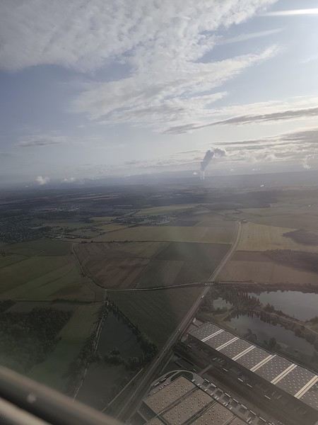
Our small but spacious CRJ-1000 Air Nostrum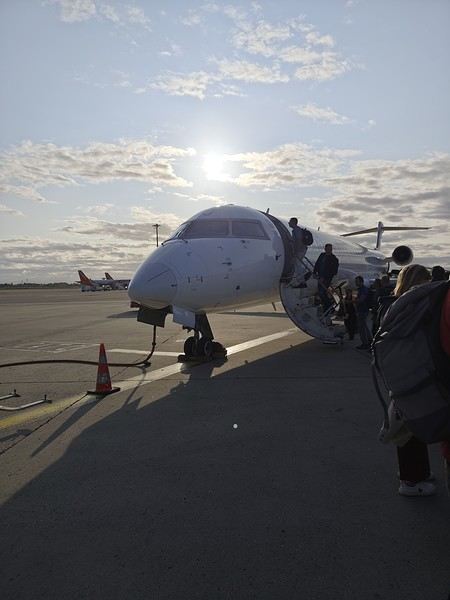 Bye-bye, Bugey nuclear plant
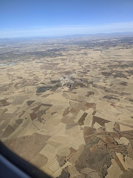
 And hello, Madrid—or rather, its very dry region.
Our layover was initially 4 hours but shrank to 1 hour due to the previous flight’s delay. That worked out for us because Terminal 4 at Barajas is way less comfortable for resting than Lyon’s T1.
And hello, Madrid—or rather, its very dry region.
Our layover was initially 4 hours but shrank to 1 hour due to the previous flight’s delay. That worked out for us because Terminal 4 at Barajas is way less comfortable for resting than Lyon’s T1.
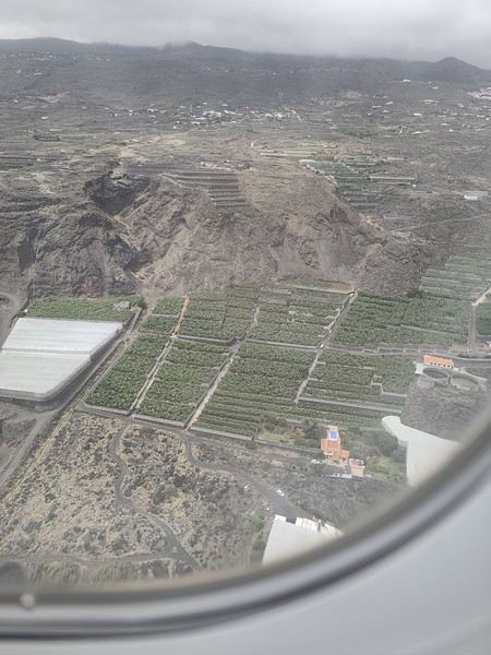
Landing with a view of Playa de la Cangrejera and del Pozo. When I say the east coast is often cloudy... 😇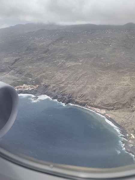 First sight of "plátano" plantations. Banana farming makes up 50% of the island’s GDP!
More to come soon. [;]
First attempt at a travel journal for me and first post after 7 years away from this forum. 😮 I went to the island of La Palma for 15 days in September 2025. After visiting Lanzarote in February, I was looking for a different and greener island. Well, I wasn’t disappointed. 😎
We stayed in Breña Baja on the east coast of the island, 5 minutes from the airport. This choice was mainly motivated by the desire not to change accommodation during the stay and to be in a "central" location close to amenities. It worked out well, but if I were to do it again, I’d split the stay in two by getting another place in the north of the island to explore that area, which really appeals to me. Note that the island is "climatically divided in two": the west coast is sunnier and drier, while the east coast is often foggy or cloudy. It’s quite impressive when you come out of the LP-3 road tunnel connecting the two sides—you feel like you’ve changed regions even though it’s less than 3 km apart.
Flight options weren’t plentiful (no direct flights from France), so I went with Iberia, connecting in Madrid for 250 € round-trip per person excluding checked baggage (80 € round-trip for one 23 kg suitcase on this route). Make sure to buy the checked baggage at the same time as your flight, as it’ll cost about 15 € more if you add it later. I booked the tickets 5 months in advance directly on Iberia’s website. You could also take a low-cost airline to Tenerife or Gran Canaria and then a flight with a Canarian carrier, but in my opinion, that only makes sense if you’re visiting one of those islands first, as the connection isn’t "guaranteed." The ferry is an option from Tenerife (about 2.5 hours crossing).
Our departure from Lyon was initially scheduled for 6 AM but took off at 9 AM so the crew could rest after the late arrival of the previous flight. This let us grab breakfast on the airline’s dime—thanks, EU Regulation (EC) No 261/2004. 😉 Iberia took a week to reimburse me after I submitted my passport, receipts, and bank details via their online claim form.
Our small but spacious CRJ-1000 Air Nostrum
Bye-bye, Bugey nuclear plant
And hello, Madrid—or rather, its very dry region.
Our layover was initially 4 hours but shrank to 1 hour due to the previous flight’s delay. That worked out for us because Terminal 4 at Barajas is way less comfortable for resting than Lyon’s T1.
Landing with a view of Playa de la Cangrejera and del Pozo. When I say the east coast is often cloudy... 😇
First sight of "plátano" plantations. Banana farming makes up 50% of the island’s GDP!
More to come soon. [;]
Join me in discovering Gran Canaria
Introduction
We stayed on the island of Gran Canaria during the first three months of 2024. It’s the third Canary Island we’ve visited, after Tenerife and Lanzarote.
We rented an apartment in Temisas. By staying in the same place for such a long period, the total price dropped by 50%.
We also rented a vehicle to make getting around the island easier.
Why the Canary Islands, and Gran Canaria in particular? For its pleasant climate, the nature and diversity of its landscapes, the charming villages, and especially the beauty of its many beaches.
In this travel journal, you’ll find a list of the many activities we did during our stay to explore the different attractions of this island.
These attractions are categorized to make it easier to find what interests you.
Videos are included throughout the summary. Click on the image to start the video.
To jump to a specific post, here are the relevant links:
HIKES:
Roque Nublo Maspalomas Dunes - Part 1 Maspalomas Dunes - Part 2 Los Azulejos de Veneguera Barranco de Las Vacas Ventana del Bentayga (Arco del Aserrador) Caves of the King Ventana de Morro (Ventana de la Ganifa) The Dog of Bentayga Cave of the Four Doors Ventana del Nublo Artenera - Caves of Acusa Seca Temisas - El Gigante Cave Fortress of Ansite Puerto de Las Nieves - Roque de Las Nieves Temisas - Cuevas de la Audiencia Roque Bentayga Guayadeque Ravine (Guayadeque Hermitage) Guayadeque Ravine (Cueva de Bartalo) El Zumacal - Barranco Tauco Casablanca Dam (Los Dolores Dam) Ayagaures - La Angostura Dam & Gambuesa Dam Santa Brígida - Alonso Ravine & Centennial Dragon Tree Pino Santo Hike in the Azuaje Ravine Gáldar - Red Lands of Samarrita Tejeda - Charco de La Paloma Bandama Boiler (Camino Borde de Caldera Bandama) Teror - Alamo Ravine Trail – SL-4 Telde - Calasio Caves Special Natural Reserve of Los Tilos de Moya Los Azulejos - Charco de Las Aneas Fataga Ravine Arinaga Military Battery Trail Maspalomas - Las Fuentes and del Canizo Ravines Mogán - Tauro Mountain Trail Tamabada - Llanos de La Mimbre & Sobre la Cueva Viewpoints Trail Hike to the Coronadero Arch via Barranco Hondo Barranco de Silva - Hike to the Jerez Caves Gáldar - Samson Cave - La Atalaya Peak Agaete - Roque Guayedra and Guayedra Ravine Artenara - Caballero Caves Arucas - Bufadero Salt Flats Barranco de Pino Gordo - Natural Pools Telde - Los Cernícalos Ravine Las Cruces - Toba Caves & Picón Puerto de Las Nieves - Moro Cave Agüimes - Morros de Ávila Caves Juncalillo del Sur - Laguna & Salinas de Abajo Caves of Camino de San Felipe Cruz de Tejeda, Cruz Chico and Degollada Viewpoint Hike on the Patalavaca Circuit Motor Grande - Puerto Rico Arch El Montañón - Los Hornos Dam Seafront Walk - Amadores Beach – Puerto Rico Beach Las Niñas Dam El Hornillo - Omega & Omicron Caves Arteara Necropolis Mogán - El Mulato Dam Las Garzas - El Regante Dam La Plata Route - Cho Flores Dam & El Charco Hondo Vega de Acusa - La Candelaria Dam Candelaria Hermitage – Acusa Seca Viewpoint Valsequillo de Gran Canaria – Roque La Vela Ayagaures Dam – GC-602 Lomo del Palo - Monte Pavón Trail Lugar La Laguna - Levada Fataga Dam & Ravine
BEACHES:
Mogán Beach Taurito Beach Tauro Beach Amadores Beach Puerto Rico Beach Anfi del Mar Beach Patalavaca Beach Meloneras Beach Maspalomas Beach English Beach (Playa del Inglés) Las Burras Beach San Agustin Beach Las Alcaravaneras Beach Las Canteras Beach (La Cicer) Las Canteras Beach (La Puntilla) Las Canteras Beach (Santa Catalina) Aquamarina Beach El Agujero - Bocabarranco Beach Hoya Del Pozo Beach Hoya Del Pozo Beach - Lizard with amputated tail El Cabron Beach Ojos de Garza Beach El Burrero Beach
NATURAL POOLS:
Charco Azul - El Risco Agaete Salt Flats Charco de Los Espejos - Sardina del Norte Natural Pools of Punta de Gáldar Snorkeling in the natural pool of Punta de Gáldar Natural Pool La Furnia o El Clavo - Gáldar Natural Pool of Los Dos Roques Emiliano Natural Pool - El Agujero Natural Pool of El Agujero Natural Pools of Roque Prieto Natural Pool El Altillo Los Charcones de Bañaderos – Arucas Natural Pools of El Charco de Las Palomas – Arucas Natural Pools of La Laja - Las Palmas de Gran Canaria Cueva de la Reina Mora - La Garita Natural Pools of Castillo del Romeral
TOWNS:
Center
Santa Brigida Vega de San Mateo Tejeda Artenara Vallesco Teror
Southwest
Santa Lucia de Tirajana Fataga San Bartolomé de Tirajana Puerto de Mogán La Aldea de San Nicolas
North
Arucas Firgas Moya Santa Maria de Guia Gáldar Agaete Puerto de Las Nieves
East
Vegueta - Las Palmas de Gran Canaria Triana - Las Palmas de Gran Canaria Ciudad Jardin - Las Palmas de Gran Canaria Canteras - Las Palmas de Gran Canaria Telde Valsequillo de Gran Canaria Ingenio Agüimes Temisas
VIEWPOINTS:
GC-60 Route (or nearby) GC-210 Route (or nearby) GC-210 Route between the tunnel and La Aldea de San Nicolás GC-215 & GC-65 Routes (or nearby) GC-200 Route (or nearby) GC-130 Route (or nearby) & GC-605 GC-70 Route (or nearby) & GC-21 Sheep herd on GC-70 Route GC-150, GC-240, GC-305, GC-350 & GC-301 Routes GC-606, GC-295, GC-231 and GC-41 Routes (or nearby) Viewpoints – GC-1 Route (or nearby) Viewpoints - Las Palmas de Gran Canaria Viewpoints - GC-2, GC-21, GC-15, GC-216 and GC-132 Routes (or nearby) Viewpoints - GC-503 & GC-217 Routes Viewpoints - GC-604, GC-505, GC-132, GC-42 and GC-802 Routes
MISCELLANEOUS:
San Rafael Aqueduct - Telde Abandoned San Rafael Estate - La Higuera Cenobio de Valerón La Cesta - Tejeda Puerto de la Aldea Scenic Route GC-671 to El Espinillo Scenic Route GC-607 to El Chorrillo The Galdar Cube (Santiago Quarry) Scenic Route GC-504 to Ayagaures Abandoned seaside resort in the Azuaje Ravine El Bufadero de La Garita – Telde GC-505 Route Abandoned Finca Las Haciendas (Los Mocanes) – Las Vegas de Valsequillo Ruins of San Juan Battery - Las Palmas de Gran Canaria Viera y Clavijo Canarian Botanical Garden - Las Palmas de Gran Canaria Tenefé Salt Flats Los Pérez, Lugarejos & Las Hoyas Dams Monte Pavón, Gran Canaria’s little Ireland Valleseco Lagoon Recreational Area Climbing - Fataga Ravine Surfing – El Agujero El Cairete Restaurant - Carrizal de Tejeda Paragliding flight observation - Los Giles La Cuevita Ayagaures Restaurant Statues and Murals - Cruce de Arinaga Aviation Monument (Las Majoreras) & Murals – Carrizal Artistic recycling by Antonio Peñita - Ojos de Garza Rainbows
We stayed on the island of Gran Canaria during the first three months of 2024. It’s the third Canary Island we’ve visited, after Tenerife and Lanzarote.
We rented an apartment in Temisas. By staying in the same place for such a long period, the total price dropped by 50%.
We also rented a vehicle to make getting around the island easier.
Why the Canary Islands, and Gran Canaria in particular? For its pleasant climate, the nature and diversity of its landscapes, the charming villages, and especially the beauty of its many beaches.
In this travel journal, you’ll find a list of the many activities we did during our stay to explore the different attractions of this island.
These attractions are categorized to make it easier to find what interests you.
Videos are included throughout the summary. Click on the image to start the video.
To jump to a specific post, here are the relevant links:
HIKES:
Roque Nublo Maspalomas Dunes - Part 1 Maspalomas Dunes - Part 2 Los Azulejos de Veneguera Barranco de Las Vacas Ventana del Bentayga (Arco del Aserrador) Caves of the King Ventana de Morro (Ventana de la Ganifa) The Dog of Bentayga Cave of the Four Doors Ventana del Nublo Artenera - Caves of Acusa Seca Temisas - El Gigante Cave Fortress of Ansite Puerto de Las Nieves - Roque de Las Nieves Temisas - Cuevas de la Audiencia Roque Bentayga Guayadeque Ravine (Guayadeque Hermitage) Guayadeque Ravine (Cueva de Bartalo) El Zumacal - Barranco Tauco Casablanca Dam (Los Dolores Dam) Ayagaures - La Angostura Dam & Gambuesa Dam Santa Brígida - Alonso Ravine & Centennial Dragon Tree Pino Santo Hike in the Azuaje Ravine Gáldar - Red Lands of Samarrita Tejeda - Charco de La Paloma Bandama Boiler (Camino Borde de Caldera Bandama) Teror - Alamo Ravine Trail – SL-4 Telde - Calasio Caves Special Natural Reserve of Los Tilos de Moya Los Azulejos - Charco de Las Aneas Fataga Ravine Arinaga Military Battery Trail Maspalomas - Las Fuentes and del Canizo Ravines Mogán - Tauro Mountain Trail Tamabada - Llanos de La Mimbre & Sobre la Cueva Viewpoints Trail Hike to the Coronadero Arch via Barranco Hondo Barranco de Silva - Hike to the Jerez Caves Gáldar - Samson Cave - La Atalaya Peak Agaete - Roque Guayedra and Guayedra Ravine Artenara - Caballero Caves Arucas - Bufadero Salt Flats Barranco de Pino Gordo - Natural Pools Telde - Los Cernícalos Ravine Las Cruces - Toba Caves & Picón Puerto de Las Nieves - Moro Cave Agüimes - Morros de Ávila Caves Juncalillo del Sur - Laguna & Salinas de Abajo Caves of Camino de San Felipe Cruz de Tejeda, Cruz Chico and Degollada Viewpoint Hike on the Patalavaca Circuit Motor Grande - Puerto Rico Arch El Montañón - Los Hornos Dam Seafront Walk - Amadores Beach – Puerto Rico Beach Las Niñas Dam El Hornillo - Omega & Omicron Caves Arteara Necropolis Mogán - El Mulato Dam Las Garzas - El Regante Dam La Plata Route - Cho Flores Dam & El Charco Hondo Vega de Acusa - La Candelaria Dam Candelaria Hermitage – Acusa Seca Viewpoint Valsequillo de Gran Canaria – Roque La Vela Ayagaures Dam – GC-602 Lomo del Palo - Monte Pavón Trail Lugar La Laguna - Levada Fataga Dam & Ravine
BEACHES:
Mogán Beach Taurito Beach Tauro Beach Amadores Beach Puerto Rico Beach Anfi del Mar Beach Patalavaca Beach Meloneras Beach Maspalomas Beach English Beach (Playa del Inglés) Las Burras Beach San Agustin Beach Las Alcaravaneras Beach Las Canteras Beach (La Cicer) Las Canteras Beach (La Puntilla) Las Canteras Beach (Santa Catalina) Aquamarina Beach El Agujero - Bocabarranco Beach Hoya Del Pozo Beach Hoya Del Pozo Beach - Lizard with amputated tail El Cabron Beach Ojos de Garza Beach El Burrero Beach
NATURAL POOLS:
Charco Azul - El Risco Agaete Salt Flats Charco de Los Espejos - Sardina del Norte Natural Pools of Punta de Gáldar Snorkeling in the natural pool of Punta de Gáldar Natural Pool La Furnia o El Clavo - Gáldar Natural Pool of Los Dos Roques Emiliano Natural Pool - El Agujero Natural Pool of El Agujero Natural Pools of Roque Prieto Natural Pool El Altillo Los Charcones de Bañaderos – Arucas Natural Pools of El Charco de Las Palomas – Arucas Natural Pools of La Laja - Las Palmas de Gran Canaria Cueva de la Reina Mora - La Garita Natural Pools of Castillo del Romeral
TOWNS:
Center
Santa Brigida Vega de San Mateo Tejeda Artenara Vallesco Teror
Southwest
Santa Lucia de Tirajana Fataga San Bartolomé de Tirajana Puerto de Mogán La Aldea de San Nicolas
North
Arucas Firgas Moya Santa Maria de Guia Gáldar Agaete Puerto de Las Nieves
East
Vegueta - Las Palmas de Gran Canaria Triana - Las Palmas de Gran Canaria Ciudad Jardin - Las Palmas de Gran Canaria Canteras - Las Palmas de Gran Canaria Telde Valsequillo de Gran Canaria Ingenio Agüimes Temisas
VIEWPOINTS:
GC-60 Route (or nearby) GC-210 Route (or nearby) GC-210 Route between the tunnel and La Aldea de San Nicolás GC-215 & GC-65 Routes (or nearby) GC-200 Route (or nearby) GC-130 Route (or nearby) & GC-605 GC-70 Route (or nearby) & GC-21 Sheep herd on GC-70 Route GC-150, GC-240, GC-305, GC-350 & GC-301 Routes GC-606, GC-295, GC-231 and GC-41 Routes (or nearby) Viewpoints – GC-1 Route (or nearby) Viewpoints - Las Palmas de Gran Canaria Viewpoints - GC-2, GC-21, GC-15, GC-216 and GC-132 Routes (or nearby) Viewpoints - GC-503 & GC-217 Routes Viewpoints - GC-604, GC-505, GC-132, GC-42 and GC-802 Routes
MISCELLANEOUS:
San Rafael Aqueduct - Telde Abandoned San Rafael Estate - La Higuera Cenobio de Valerón La Cesta - Tejeda Puerto de la Aldea Scenic Route GC-671 to El Espinillo Scenic Route GC-607 to El Chorrillo The Galdar Cube (Santiago Quarry) Scenic Route GC-504 to Ayagaures Abandoned seaside resort in the Azuaje Ravine El Bufadero de La Garita – Telde GC-505 Route Abandoned Finca Las Haciendas (Los Mocanes) – Las Vegas de Valsequillo Ruins of San Juan Battery - Las Palmas de Gran Canaria Viera y Clavijo Canarian Botanical Garden - Las Palmas de Gran Canaria Tenefé Salt Flats Los Pérez, Lugarejos & Las Hoyas Dams Monte Pavón, Gran Canaria’s little Ireland Valleseco Lagoon Recreational Area Climbing - Fataga Ravine Surfing – El Agujero El Cairete Restaurant - Carrizal de Tejeda Paragliding flight observation - Los Giles La Cuevita Ayagaures Restaurant Statues and Murals - Cruce de Arinaga Aviation Monument (Las Majoreras) & Murals – Carrizal Artistic recycling by Antonio Peñita - Ojos de Garza Rainbows
The North Cape by 4x4 in the Snow
Our trip lasted a month, from March 10 to April 10, 2024, and was done aboard our Land Rover Defender 110. For those interested, our 4x4 is equipped with mountain-approved 3PMFSF all-terrain tires (non-studded), a removable electric winch that can be attached to either the front or rear of the vehicle, two sand recovery boards, and we bring two pairs of snow chains. We sleep in our Land Rover, which is equipped with a diesel-powered independent heater, a small fridge, and has a layout that allows the dinette to be converted into a bed.
Starting from the Paris region, we crossed Belgium and Germany, took the ferry from Travemünde in northern Germany to Helsinki, followed the Russian border up to northern Finland, then headed into Norway all the way to the North Cape before returning via Norway, taking the ferry from Larvik in Norway to Hirtshals in Denmark, then passing through Germany and Belgium on our way back to France.
Tonight, March 10, 2024, we’ll be sleeping at our daughter’s place in the North.
Tuesday, March 11, we’ll cross Belgium and then enter Germany, where we’ll camp in Bremen.
Wednesday, March 12, we’ll have a quick visit to Bremen in the morning. We had planned to visit Lübeck, but some electrical issues with the car delayed us, so we head straight to the German port of Travemünde, where we’re set to embark at 11:30 PM to cross the Baltic Sea and arrive in Helsinki after 31 hours of sailing (one-way cabin ticket cost: 850 €—quite expensive since we booked last minute).
On the ferry, there are mostly semi-trucks and only a few campervans and passenger cars. The boat is quiet, and the Baltic Sea is calm.
About two hours before arriving in Helsinki, we hear noise along the hull. Surprise—looking out the porthole, we realize we’re sailing on frozen sea ice!
Thursday, March 14, we arrive at the port of Helsinki at 9:30 AM. Disembarking takes a while. As soon as we’re out, we head straight to Rastila Camping (cost: 27 €), about ten kilometers east of Helsinki. Then we go to a Land Rover garage to fix our headlight switch, which stopped working (a real hassle in Finland since you have to drive with low beams on at all times).
After the repair, we visit the stunning Temppeliaukio Church, which is built underground.
On our way back to the campsite, we stop at the supermarket for supplies. Prices are similar to France, except for imported products.
We settle into our snowy campsite spot.
Starting from the Paris region, we crossed Belgium and Germany, took the ferry from Travemünde in northern Germany to Helsinki, followed the Russian border up to northern Finland, then headed into Norway all the way to the North Cape before returning via Norway, taking the ferry from Larvik in Norway to Hirtshals in Denmark, then passing through Germany and Belgium on our way back to France.
Tonight, March 10, 2024, we’ll be sleeping at our daughter’s place in the North.
Tuesday, March 11, we’ll cross Belgium and then enter Germany, where we’ll camp in Bremen.
Wednesday, March 12, we’ll have a quick visit to Bremen in the morning. We had planned to visit Lübeck, but some electrical issues with the car delayed us, so we head straight to the German port of Travemünde, where we’re set to embark at 11:30 PM to cross the Baltic Sea and arrive in Helsinki after 31 hours of sailing (one-way cabin ticket cost: 850 €—quite expensive since we booked last minute).
On the ferry, there are mostly semi-trucks and only a few campervans and passenger cars. The boat is quiet, and the Baltic Sea is calm.
About two hours before arriving in Helsinki, we hear noise along the hull. Surprise—looking out the porthole, we realize we’re sailing on frozen sea ice!
Thursday, March 14, we arrive at the port of Helsinki at 9:30 AM. Disembarking takes a while. As soon as we’re out, we head straight to Rastila Camping (cost: 27 €), about ten kilometers east of Helsinki. Then we go to a Land Rover garage to fix our headlight switch, which stopped working (a real hassle in Finland since you have to drive with low beams on at all times).
After the repair, we visit the stunning Temppeliaukio Church, which is built underground.
On our way back to the campsite, we stop at the supermarket for supplies. Prices are similar to France, except for imported products.
We settle into our snowy campsite spot.
7-day mini road trip in Corsica: your thoughts?
Hi everyone, after a stay in the South and one in the North, I’m planning a mini road trip in Corsica (Bastia-Bastia) in June to explore places I haven’t seen yet. Since we’re heading to the mountains later this year, we’ve deliberately skipped the Corsican mountains. Could you share your thoughts and, most importantly, suggest things to see? We love nature, reasonable hikes, peaceful spots, and small villages. No cities. No boat excursions (yes, that includes Piana and Scandola). We already know the area between Bastia and Calvi.
June 7 Flight arrival in Bastia and night at the hotel
June 8 Drive to Calvi (beach and/or fortress) Meal at Les Boucaniers restaurant Night in Calvi
June 9 Walk from Calvi fortress to Alga beach Charcuterie platter at A Casetta Calvi Night in Calvi
June 10 Drive from Calvi to Piana Buvette du col de la Croix and visit the orientation table Chemin des muletiers (Muleteers’ Path) Or Sentier de la source des roches bleues (Blue Rocks Spring Trail) counterclockwise Or (less scenic) Tête du chien (Dog’s Head, starting at the parking lot) Dinner at Épicerie Castellani in Piana Night in Piana
June 11 Drive from Piana to Propriano Arone beach and meal at Le Café de la plage Drive along the coast, stopping wherever we like Night in Propriano
June 12 Hike starting from Campomoro in the Jardin du Vent (Wind Garden), and visit the Genoese tower of Campomoro Meal in Campomoro: restaurant Chez Pierre Paul U spuntinu Night in Propriano
June 13 Around Propriano (avoid Capu Laurosu beach—sewage treatment plant...) Night in Propriano
June 14 Drive from Propriano to Bastia airport Meal at L’Éternisula in Zonza Aiguilles de Bavella (Hole of the Bomb) Night at the same hotel as arrival
June 15 Departure
June 7 Flight arrival in Bastia and night at the hotel
June 8 Drive to Calvi (beach and/or fortress) Meal at Les Boucaniers restaurant Night in Calvi
June 9 Walk from Calvi fortress to Alga beach Charcuterie platter at A Casetta Calvi Night in Calvi
June 10 Drive from Calvi to Piana Buvette du col de la Croix and visit the orientation table Chemin des muletiers (Muleteers’ Path) Or Sentier de la source des roches bleues (Blue Rocks Spring Trail) counterclockwise Or (less scenic) Tête du chien (Dog’s Head, starting at the parking lot) Dinner at Épicerie Castellani in Piana Night in Piana
June 11 Drive from Piana to Propriano Arone beach and meal at Le Café de la plage Drive along the coast, stopping wherever we like Night in Propriano
June 12 Hike starting from Campomoro in the Jardin du Vent (Wind Garden), and visit the Genoese tower of Campomoro Meal in Campomoro: restaurant Chez Pierre Paul U spuntinu Night in Propriano
June 13 Around Propriano (avoid Capu Laurosu beach—sewage treatment plant...) Night in Propriano
June 14 Drive from Propriano to Bastia airport Meal at L’Éternisula in Zonza Aiguilles de Bavella (Hole of the Bomb) Night at the same hotel as arrival
June 15 Departure
Travel companion for a mountain-bike crossing of the Atacama (Chile, Bolivia, Argentina) in October 2025
I’m planning a journey of about 2500 km starting from San Pedro de Atacama (duration: max. 2 months). This trip, almost entirely on remote trails, promises to be an extraordinary adventure.
Highlights of the trip - Crossing the Florido Desert (during the blooming season: October 15–30) - Hiking ascents of legendary volcanoes: - Ojos del Salado (6879 m) - Llullaillaco (6739 m) - Uturuncu (6008 m, with 5820 m reachable by mountain bike!) - A 300 km stage through the heart of the desert, with no resupply or habitation: the ultimate experience of solitude and self-transcendence.
Practical details - Daily distance: max. 100 km and 1000 m elevation gain per day - Average altitude: 4000 m (between 3500 and 5000 m) - Temperatures: ~15 °C during the day, down to -25 °C at night (in a tent) - Accommodation: ~50% in villages (with locals or small hostels), ~50% camping
Estimated budget - 1400 € for the flight ticket (including bike supplement) - 1000 € for on-the-ground expenses
Required equipment - Fatbike (essential for deep sand) - -25 °C comfort sleeping bag - Single-wheel trailer (indispensable for these tough terrains)
My experience In 2022, I completed a similar 1200 km trip north of San Pedro de Atacama: - Full crossing of the Salar de Uyuni (170 km) - Ascents of the Ollague (5868 m) and Aucanquilcha (6176 m) volcanoes - Two 200 km stages with no resupply or human presence Videos available for a glimpse of the adventure: - Atacama Crossing 2022 - Part 1 - Atacama Crossing 2022 - Part 2
Next steps If this adventure interests you, I suggest: 1. A first phone call to get to know each other 2. A meet-up over a drink or a test ride in the Bardenas Reales (similar terrain, and I live 100 km away)
Don’t hesitate to contact me for more info or to discuss the details!
Highlights of the trip - Crossing the Florido Desert (during the blooming season: October 15–30) - Hiking ascents of legendary volcanoes: - Ojos del Salado (6879 m) - Llullaillaco (6739 m) - Uturuncu (6008 m, with 5820 m reachable by mountain bike!) - A 300 km stage through the heart of the desert, with no resupply or habitation: the ultimate experience of solitude and self-transcendence.
Practical details - Daily distance: max. 100 km and 1000 m elevation gain per day - Average altitude: 4000 m (between 3500 and 5000 m) - Temperatures: ~15 °C during the day, down to -25 °C at night (in a tent) - Accommodation: ~50% in villages (with locals or small hostels), ~50% camping
Estimated budget - 1400 € for the flight ticket (including bike supplement) - 1000 € for on-the-ground expenses
Required equipment - Fatbike (essential for deep sand) - -25 °C comfort sleeping bag - Single-wheel trailer (indispensable for these tough terrains)
My experience In 2022, I completed a similar 1200 km trip north of San Pedro de Atacama: - Full crossing of the Salar de Uyuni (170 km) - Ascents of the Ollague (5868 m) and Aucanquilcha (6176 m) volcanoes - Two 200 km stages with no resupply or human presence Videos available for a glimpse of the adventure: - Atacama Crossing 2022 - Part 1 - Atacama Crossing 2022 - Part 2
Next steps If this adventure interests you, I suggest: 1. A first phone call to get to know each other 2. A meet-up over a drink or a test ride in the Bardenas Reales (similar terrain, and I live 100 km away)
Don’t hesitate to contact me for more info or to discuss the details!
21-Day Trip to La Gomera and La Palma
Travel Journal: 21 Days in La Gomera and La Palma
From February 6 to February 26, 2024
Tuesday, February 6 We left around 9 AM with our car, along with Pierre-Paul and Patricia, heading to the Bluepark parking lot in Bartenheim. As expected, we were awaited and left promptly for EuroAirport Basel. Took off at 12:25 PM for a 4-hour-15-minute flight under excellent conditions. Beautiful arrival in Tenerife with Teide in sight under a clear blue sky. Fifteen minutes later, we waited for bus No. 40 to Los Cristianos with quite a few other tourists, but we managed to find four seats. From the bus station, it was a 20-minute walk to our hotel. We checked into a lovely apartment for the four of us, complete with all the comforts. Outside, it was quite warm—at least 25°C! After dropping off our luggage, we went for a stroll. The immediate surroundings of the hotel held no interest for us: a modern, concrete area filled with hotels, bars, tourist agencies, and unappealing restaurants all offering the same bland international cuisine. Pat went to cool off at the pool, unfortunately overrun by loud, drunk English tourists. I took a walk to the paseo maritimo that leads to the port, skirting the seafront. The promenade was pleasant, but it could have been any seaside resort in the world—same old scene: a succession of bars with blaring music where many elderly people sipped cold beers waiting for the sunset, the backdrop a wall of resort-style hotels resembling rabbit hutches! Upon reaching the port, I scouted the route we’d take the next day to the Fred Olsen ferry. Back at the apartment, in the early evening, we looked for a non-touristy restaurant for dinner. Monique stopped a woman to ask her opinion! In this area, she told us, there’s no restaurant that serves Canarian or Spanish cuisine! The only place with decent restaurants is at the port. Off we went to the port, where we sat down at Al Bordo restaurant and ordered a seafood paella for four. Excellent, and at a very reasonable price (36 € for two). We returned to the hotel along the seafront.
Wednesday, February 7
Woke up at 6 AM. Had breakfast in the apartment with what we’d bought the day before at a supermarket. It was still dark when we left on foot toward the port, walking along the calm seafront at this early hour. Forty minutes later, we arrived and waited 10 minutes before the ferry docked. At 9:30 AM, we left the port of Los Cristianos for a 50-minute crossing on a calm sea under a beautiful blue sky. There were quite a few people on this large ferry, but many had no luggage, meaning they were visiting La Gomera for the day and would take the ferry back in the evening. Upon disembarking, we went straight to our rental car agency to pick up the car we’d booked online a few months earlier. It was a nice Peugeot 2008, spacious enough for the four of us and our luggage. We immediately took the beautiful road from San Sebastián that climbs directly into the mountains toward our rental in Vallehermoso. The road was in perfect condition—it seemed brand new, like all the others we’d take on this island later. This side of the island is very arid with little vegetation, and the terrain is particularly rugged, as it is throughout the island. We stopped at our first miradors, which would be followed by many more throughout our Canarian trip. Our first visit was to the small village of Agulo, perched on a promontory above the sea and at the foot of a high cliff. The village features typical Canarian houses with windows flush with the façade and black volcanic stone masonry on white or reddish-brown walls. The first recommended restaurant was already booked for a group, so we settled for the shaded terrace of the excellent El Alameda bar-restaurant. From Agulo, you can access the Abrante viewpoint via a winding road, where the view of Agulo, 600 meters below, is exceptional. A glass ledge over the void lets you test your fear of heights!
We drove to Vallehermoso to do our grocery shopping at the supermarket—a habit that would continue until the end of the trip. Our little house, "Casa rural El Encatadora," is located in a beautiful flower-filled valley a few kilometers west of Vallehermoso. Each of us had a bedroom with an en-suite bathroom, plus a living room, kitchen, and a small terrace overlooking the quiet street at the valley’s end, which didn’t bother us at all.
Thursday, February 8 The good weather seemed to follow us since our arrival in the Canary Islands. This morning, we took the road—still as beautiful and new—toward Arure, high up to the west. The landscape was magnificent, with breathtaking glimpses of the sea far below. In Arure, we parked in front of Conchita’s bar, where a hike (Rother No. 30) starts toward two viewpoints: Alojera, which we reached after 45 minutes on a lovely path. Monique, tired from the first steep climb, stopped at the first viewpoint and hitchhiked back to Arure. Meanwhile, we continued toward the second viewpoint, Los Barranquillos, where the view of the surroundings was partially hidden by misty clouds rising from the sea. The entire mountain is sculpted by ancient, endless terraces climbing until the slope becomes too steep for construction—visible traces of the hard work of past inhabitants trying to survive in a harsh environment. We had a decent lunch at La Conchita bar, then drove to the small seaside town of Puerto la Caleta, sheltered by an immense cliff plunging into the sea. Black sand beach, rough sea—despite our encouragement, Pat didn’t dare to swim! As for the old village of Caleta, it’s perched on the mountainside, and visiting it requires climbing steep, stair-filled alleys to discover a few traditional houses. Back at the casa, dinner in, and card games...
 Vallehermoso
Friday, February 9 This morning, the sky was overcast, and the peaks around us were shrouded in clouds. We took the same road as yesterday to hike Las Creces. Quickly gaining altitude, we entered a thick fog—visibility was very limited. We stopped at the Las Creces parking lot; visibility improved, and the sun wasn’t far off. The hike is entirely within a beautiful laurel forest, with the sun playing hide-and-seek, but it wasn’t cold despite the altitude. After finishing the loop trail, we decided to picnic—not there, as it was too chilly—but on Vallehermoso’s beach, where we found a nice picnic area sheltered by large black rocks. A short digestive walk on the surrounding hill to admire the little beach from above. Back in Vallehermoso, we did some grocery shopping, then tried to return to the casa—only to find ourselves locked out because we’d left the key in the lock inside! After several attempts and with the help of Yéli, a relative of the owner we called for help, we were finally able to get back in!
Saturday, February 10
It rained last night, and the sky remained overcast. Monique decided to rest this morning. PP, Pat, and I set off on the hike that starts from the house toward the Marichal reservoir. The sun wasn’t far off, and by 11 AM, it was fully out. The pleasant hike passed by many flower-filled gardens and orchards—orange, lemon, and mandarin trees in fruit. The path climbed gently toward the reservoir, where the view of the Cano rock dominating the landscape was magnificent. The last part of the climb was a bit tough, overgrown with lush vegetation, and the trail was slippery from last night’s rain. We descended via a different, much more pleasant path and returned to the casa just in time for lunch, prepared by Monique. This valley is rich with its many farmers and market gardeners who’ve cultivated the entire valley, taking advantage of the water flowing down from the mountain, captured upstream and redistributed through countless pipes snaking along the paths. Numerous tanks also store water during dry periods. The houses are scattered across both sides of the valley, and these colorful little homes add a beautiful touch to the landscape. The many palm trees give this valley a distinctly tropical feel—you could almost imagine yourself in the Caribbean. Add to that some salsa music drifting from a hut where farmers were working, and the picture is complete. A well-chilled beer apéro capped off a lovely morning. The afternoon was dedicated to rest, relaxation, reading, and games.
Sunday, February 11 The blue sky returned, though a few clouds still capped the highest peaks. Today, we visited Garajonay National Park, which covers the highest central mountains. Up there, we were above the clouds, and the panoramas from the various viewpoints were stunning: first, Cherelepin, accessible from the Laguna Grande parking lot, then Alto de Garajonay, offering an exceptional view of Teide—over 3,000 meters high—emerging from the clouds on Tenerife, far in the distance. We continued to the Los Roques viewpoints, then stopped for lunch at the Degollada de Peraza restaurant, where the view of the barranco was impressive. We descended toward San Sebastián and checked into our new lodging, La Cabezada, located in the countryside about 3 km above San Sebastián. It’s a small apartment adjacent to the owner’s, with a lovely terrace overlooking the surrounding mountains and surrounded by a beautiful garden. Apéro, then dinner on our beautiful terrace.
Monday, February 12 This morning, we went down to visit San Sebastián de La Gomera: its old tower, main street with some beautiful traditional houses, and the Church of the Assumption. Back at the casa for lunch. In the afternoon, Pat, PP, and I set off on the short hike from San Sebastián beach to La Guancha beach. We drove down and parked on the beach. The path climbs along the hill overlooking San Sebastián, passes by the tall Christ statue dominating the landscape, and roughly follows the coast down to the isolated Guancha beach. A beautiful hike under a hot sun, and a swim was welcome, even if the beach and sea access weren’t very comfortable due to large pebbles and quickly deepening water. Apart from two nudist bathers, there was no one on this beach. We returned the same way.
Tuesday, February 13 Rest day. We went down to town to stroll and do some shopping. I took the opportunity to visit the parador, beautifully situated above the city in a lovely garden overlooking the port and town. Together, we went for a cuba libre at the "Cuba Libre" bar, then had lunch at Breñusca (mediocre paella!). Back at the casa, then we went back down to town to see a carnival parade, a "passacalles," which actually passed an hour earlier than scheduled. Oh well.
Wednesday, February 14 Each to their own program this morning. Pat went swimming at San Sebastián beach, Monique rested at the casa, and PP and I set off on the hike from Playa de Avalos to the Ermita de Guadalupe on Playa del Cangrejo. It wasn’t easy to find the right road or the parking spot, but we managed. The path seemed to have suffered landslides, according to a sign at the trailhead! We decided to check it out, ready to turn back if it seemed too dangerous. In the end, apart from one or two slightly tricky spots where we had to climb a pile of rocks, the trail remained passable, though a bit vertigo-inducing in places. The narrow path clings to very vertical cliffs nearly 300 meters above sea level! But what a magnificent view. At one point, the trail runs alongside a wall of basaltic pipes. We returned via the drivable track that parallels the trail a bit lower. Back at the house for lunch. In the late afternoon, we returned to town to attend the "Entierro de las Sardinas" (Burial of the Sardine), which closes the Canarian carnival festivities. While waiting, we strolled through the parador’s gardens and had mojitos in town. Around 9 PM, we heard the noise and cries of the mourners. The procession advanced, led by a large papier-mâché sardine on a float, surrounded by wailing mourners. The procession headed toward the sea, where the sardine was burned, and a mini fireworks display ended the procession. It was all very good-natured, and everyone had fun. We ended the evening with dinner at a good fish restaurant, El Pajar.
 Entierro de la Sardina in San Sebastián de La Gomera
Thursday, February 15
Woke up at 5:15 AM. The only suitable ferry was at 7 AM, which would get us to La Palma by late morning rather than evening. We packed our bags, had breakfast, then headed to the port, left our rental car, and boarded the ferry to Tenerife, from where we’d continue to La Palma. Calm sea, beautiful sun—by 10:30 AM, we disembarked in La Palma. We picked up our car and immediately headed to our new apartment in Breña Alta. It’s a large apartment with a superb terrace facing the sea, fully equipped and very comfortable. The hosts recommended Casa Goyo restaurant, near the airport and close to us. It’s a restaurant with many small rooms, some of which can be reserved for families. The fish-based cuisine (chipirones, pulpo) was excellent, hearty, and reasonably priced. Since it’s in the airport’s flight path, we occasionally heard planes landing. Quick and efficient service. Afterward, we visited Santa Cruz de La Palma, which reminded us of the historic quarters of La Orotava in Tenerife or the capital of Gran Canaria.
Friday, February 16
Beautiful weather, blue sky. We headed to the San Bartolo viewpoint toward the northeast coast, then to the lovely village of San Andrés, which we explored. From there, we walked along the shore to the natural pools of Charco Azul, where we swam in the cool but "swimmable" sea. Back in San Andrés for lunch at the "San Andrés" restaurant on the beautiful church square. Very good fish-based meal. We got back in the car and continued along the north coast to the port of Espindola and the natural pools of Fajana near the Cumplida lighthouse. A fairly strong wind whipped up beautiful waves crashing onto the rocky coast in bursts of foam. Back in Santa Cruz, we stopped at the Mercadona supermarket to buy fresh shrimp for dinner. San Andrés
Saturday, February 17
Uniform blue sky, even on the heights. We took the beautiful road that winds up to the summit of the Caldera de Taburiente. Several viewpoints offer 360° views of the entire island and beyond: you can make out La Gomera, El Hierro, and, of course, Tenerife with the perfect triangle of Teide. We parked at the Los Andes viewpoint parking lot and started our hike to Pico de la Cruz along a trail following the ridge, offering superb views into the caldera. We got back in the car and passed by the Roque de los Muchachos astronomical complex, composed of numerous observatories, some with very aesthetic mirror telescopes. We hiked from the Roque de los Muchachos parking lot to the various viewpoints, always as impressive. Picnic on site, then back to Santa Cruz. We stopped by our car dealer because the oil warning light came on—better safe than sorry. The representative reassured us but preferred to give us a Fiat Cross SUV instead. The Caldera de Taburiente
Sunday, February 18 The weather was a bit mixed, with cloudy patches. We set off to hike the Barranco de la Cuba de Galga. Unfortunately, the Los Tilos trail had been closed for several months due to a major landslide. The parking lot by the road was already quite full, and indeed, we crossed paths with many hikers along the way—it’s an easy hike with little elevation gain, which is rare here in La Palma! The beautiful path winds through a very narrow, deep gorge covered in lush tropical vegetation—you’d think you were in a Southeast Asian forest, especially with the humidity in the gorge bringing out earthy and floral scents. Halfway through, Monique turned back while the rest of us continued to the Cuba de Galga. A light drizzle accompanied us on the return. For lunch, we went to Chipi Chipi restaurant in the heights of Santa Cruz. The cool air forced us to leave the lovely terrace for the slightly noisy dining room. The meal was very good and hearty. Afternoon spent resting at our house.
 La Cuba de la Galga
Monday, February 19 A few clouds still clung to the nearby mountain peaks. We headed south to Los Canarios. We stopped in front of the small San Antonio Abad church, where a path leads to the viewpoint in 15 minutes. Then we visited the San Antonio Volcano Interpretation Center and climbed to the viewpoint via the trail along the crater’s edge, offering a plunging view into the crater. Then PP, Pat, and I headed toward the Teneguía volcano but turned back given the remaining distance and the intense heat bearing down on us! Plus, the landscape was rather arid and not very interesting. We got back in the car and drove down to the salt flats at the island’s southern tip. The ocean crashes here in large waves, exploding against the volcanic rocks and feeding a "blowhole" carved into the rock. We stopped for drinks at the salt flats restaurant, then headed home. The salt flats in Fuencaliente
Tuesday, February 20 Beautiful weather with a few clouds clinging to the mountains, as usual. A relaxed morning since my parking reservation at La Cumbrecita didn’t start until 1 PM. It takes about 30 minutes from Santa Cruz to reach the valley floor via a beautiful but narrow road toward the end, though there’s very little traffic. Meanwhile, the clouds had disappeared, and the view from the La Cumbrecita viewpoint was superb. We recognized Pico de la Cruz in the distance, where we’d been a few days earlier. We then took the path leading to the Las Chozas viewpoint through a magnificent Canarian pine forest. We picnicked on site, then took the path to the Los Roques viewpoint. We returned the same way since the direct route was closed for construction. Back in Santa Cruz, we visited the Sanctuary of Las Nieves, with its beautiful golden Baroque altar. Hike from La Cumbrecita
Wednesday, February 21 After packing our things and loading the car, we left Santa Cruz under a very blue sky for Los Llanos de Aridane, where we stopped to visit this lovely town. The Church of Nuestra Señora de los Remedios has a beautiful coffered ceiling and an original papier-mâché Christ statue from the 16th century. Around it, colorful old Canarian houses brighten the streets of the town center. We took the opportunity to stroll, do some shopping, and finally sat down at La Pergola restaurant for a mediocre lunch. We got back in the car to check into our new house in Arecida. On the way, we stopped at the Mirador del Time, which once again offered an impressive panorama, allowing us—for the first time—to see the damage caused by the Tajogaite volcano eruption in 2021. You can clearly see the still-smoking crater and the large black lava flow covering the landscape down to the sea. We really liked our new accommodation: a local house that’s been renovated on the heights of Arecida, not far from the Canarian pine forest. From several terraces, we have a 360° view of the sea and mountains. We even have a private pool! There are two beautiful, brand-new bedrooms, each with its own bathroom—the best. Plus, we’re on the GR 131 trail that runs along the Barranco de las Angustias toward the northeast.
 Los Llanos de Aridane
Thursday, February 22 Once again, beautiful weather greeted us when we woke up. We started the GR 131 with the goal of reaching the Torre del Time viewpoint—about 400 meters of elevation gain. The path, quite steep at first, winds through a superb Canarian pine forest. A few viewpoints let you appreciate the sheer drop of the Barranco de las Angustias—watch out for vertigo! At the Torre del Time viewpoint, there’s a nearly 1,000-meter vertical drop. We returned via another path, the PLP1, which meanders first through this beautiful forest, then along lovely flower-filled gardens adjacent to beautiful properties that cascade from the forest down to the road serving these neighborhoods. This afternoon, we tried to get closer to the area devastated by the 2021 lava flows. Several roads are still closed or reserved for residents, while others—brand new—have been rebuilt to open up this densely populated and cultivated region. In some places, the lava flow slightly diverted, sparing some properties that logically should have disappeared. Now, they’re encircled by a massive cooled lava field. In other spots, twisted and charred metal scraps or greenhouse remains protrude from the lava—all that’s left of the former banana plantations. A little higher up, you can see the slightly smoking crater of Tajogaite, responsible for this disaster. Back to Casa Barreros.
 View of Los Llanos and, in the background, the 2021 lava flow
Friday, February 23
Though the sky was still blue, the temperature had dropped due to a chilly wind. By midday, it still rose to 22°C. Today, we headed north, specifically to the town of Tijarafe, where a very narrow road descends to the small port, Porís de Candelaria. The 3.7-kilometer road drops 700 meters in elevation, with gradients up to 30%—it was going to be intense! Indeed, the descent was scary, with the void right next to the very narrow road where passing was impossible except at a few rare spots. Everything went well—there was little traffic at this early hour. From the parking lot at the bottom, a path leads to Porís de Candelaria. It’s surprising to see this small fishing hamlet nestled in the shelter of an immense cave opening onto the sea, which was quite rough today. The sun, at this time of year, would appear late in the cave, which remained in shadow for much of the day. We returned via the same road, strolled through the small town of Puntagorda, and had lunch at El Jardín de los Naranjos restaurant—excellent meal. Fishing hamlet of Candelaria
Saturday, February 24 The air was still cool, but the sun was beautiful. While Monique stayed home to rest, the three of us headed to the village of Las Tricias to hike the Buracas Caves trail. We left the car parked on the LP1 road and took the small paved road down to the sign marking the trail’s start. The signage for all the trails we took here, as in La Gomera, was very well done. The path descended steadily, then more steeply toward the caves where the island’s first inhabitants lived—some petroglyphs are still visible in certain caves. The path then climbed back up, passing magnificent dragon trees and more or less elaborate huts occupied by Germans who’ve lived here for many years. Back at Casa Barreros for some rest.
Sunday, February 25 The weather once again blessed us with a beautiful day. This morning, we visited the local produce market held on weekends in Puntagorda. You’ll find agricultural products, crafts, and food to keep you going. A little further on, there’s a glass viewpoint overlooking the barranco plunging toward the sea, with a view of the thrill-seekers trying the zip line right next to it. Lunch at Naranjos—definitely a good spot—with their shrimp and spice tagliatelle. Back home for an afternoon of relaxation.
Monday, February 26 We left Arecida under a cloudy sky. Driving up from Los Llanos de Aridane toward the east, an enormous cascade of clouds poured from the mountain peaks into the Los Llanos plain—very impressive. Arriving in Santa Cruz, we went for a stroll, did some last-minute shopping, then had a final good-quality paella at La Chalana on the paseo maritimo. We left the car in the parking lot and took the 5 PM Olsen ferry to Tenerife on a slightly choppy sea, but the ferry didn’t rock too much. Arriving at 7:15 PM, we dropped off our things near the port in our reserved apartment and went for dinner at Abordo—rubbery chipirones. A digestive stroll among the ever-increasing number of tourists in Los Cristianos—restaurants were packed to the brim, the season is in full swing here. Gone is the calm of La Gomera and La Palma, and the laid-back tourism of German hikers among whom a few French were hiding!
Tuesday, February 27 To make our homemade breakfast more enjoyable, we went to buy pastries at the local bakery, then took one last walk on the paseo along the beaches, mingling with the many mobility scooters driven by elderly or disabled people, joggers, and tourists. Last apéro near the bus station, then off to the airport. After a smooth 4-hour-30-minute flight, we arrived in Basel-Mulhouse at 10:20 PM.
THE END
Conclusion A fantastic trip to two islands with magnificent and diverse nature, where landscapes range from desert-like to tropical depending on exposure to winds and clouds. Thanks to the many beautiful viewpoints, you can truly appreciate these exceptionally dynamic reliefs. A hiker’s paradise, the trails are all very well marked, though the choice of easy or moderate paths for "casual walkers" is quite limited. Another notable advantage, in our opinion, is that these islands are very lightly developed—you’ll hardly see any of those ugly hotel blocks that spoil the landscapes of some other Canary Islands. It’s true that the beaches on these two islands don’t meet traditional international tourism criteria: they’re small, with black sand, and often difficult to access. Special mention for the quality of the road network (except for a few small local roads), which seems brand new, well-paved, and well-signposted. We also enjoyed exceptional weather for February, with fewer than three days of gray or rainy weather out of 21.
Almost all the accommodations we chose met or exceeded our expectations, often at reasonable prices: an average of 98 € per night for an apartment or house with two bedrooms for four people.
All photos can be viewed by clicking this link: https://photos.app.goo.gl/G44pPk4g9PW1rNzg8
Tuesday, February 6 We left around 9 AM with our car, along with Pierre-Paul and Patricia, heading to the Bluepark parking lot in Bartenheim. As expected, we were awaited and left promptly for EuroAirport Basel. Took off at 12:25 PM for a 4-hour-15-minute flight under excellent conditions. Beautiful arrival in Tenerife with Teide in sight under a clear blue sky. Fifteen minutes later, we waited for bus No. 40 to Los Cristianos with quite a few other tourists, but we managed to find four seats. From the bus station, it was a 20-minute walk to our hotel. We checked into a lovely apartment for the four of us, complete with all the comforts. Outside, it was quite warm—at least 25°C! After dropping off our luggage, we went for a stroll. The immediate surroundings of the hotel held no interest for us: a modern, concrete area filled with hotels, bars, tourist agencies, and unappealing restaurants all offering the same bland international cuisine. Pat went to cool off at the pool, unfortunately overrun by loud, drunk English tourists. I took a walk to the paseo maritimo that leads to the port, skirting the seafront. The promenade was pleasant, but it could have been any seaside resort in the world—same old scene: a succession of bars with blaring music where many elderly people sipped cold beers waiting for the sunset, the backdrop a wall of resort-style hotels resembling rabbit hutches! Upon reaching the port, I scouted the route we’d take the next day to the Fred Olsen ferry. Back at the apartment, in the early evening, we looked for a non-touristy restaurant for dinner. Monique stopped a woman to ask her opinion! In this area, she told us, there’s no restaurant that serves Canarian or Spanish cuisine! The only place with decent restaurants is at the port. Off we went to the port, where we sat down at Al Bordo restaurant and ordered a seafood paella for four. Excellent, and at a very reasonable price (36 € for two). We returned to the hotel along the seafront.
Wednesday, February 7
Woke up at 6 AM. Had breakfast in the apartment with what we’d bought the day before at a supermarket. It was still dark when we left on foot toward the port, walking along the calm seafront at this early hour. Forty minutes later, we arrived and waited 10 minutes before the ferry docked. At 9:30 AM, we left the port of Los Cristianos for a 50-minute crossing on a calm sea under a beautiful blue sky. There were quite a few people on this large ferry, but many had no luggage, meaning they were visiting La Gomera for the day and would take the ferry back in the evening. Upon disembarking, we went straight to our rental car agency to pick up the car we’d booked online a few months earlier. It was a nice Peugeot 2008, spacious enough for the four of us and our luggage. We immediately took the beautiful road from San Sebastián that climbs directly into the mountains toward our rental in Vallehermoso. The road was in perfect condition—it seemed brand new, like all the others we’d take on this island later. This side of the island is very arid with little vegetation, and the terrain is particularly rugged, as it is throughout the island. We stopped at our first miradors, which would be followed by many more throughout our Canarian trip. Our first visit was to the small village of Agulo, perched on a promontory above the sea and at the foot of a high cliff. The village features typical Canarian houses with windows flush with the façade and black volcanic stone masonry on white or reddish-brown walls. The first recommended restaurant was already booked for a group, so we settled for the shaded terrace of the excellent El Alameda bar-restaurant. From Agulo, you can access the Abrante viewpoint via a winding road, where the view of Agulo, 600 meters below, is exceptional. A glass ledge over the void lets you test your fear of heights!
We drove to Vallehermoso to do our grocery shopping at the supermarket—a habit that would continue until the end of the trip. Our little house, "Casa rural El Encatadora," is located in a beautiful flower-filled valley a few kilometers west of Vallehermoso. Each of us had a bedroom with an en-suite bathroom, plus a living room, kitchen, and a small terrace overlooking the quiet street at the valley’s end, which didn’t bother us at all.
Thursday, February 8 The good weather seemed to follow us since our arrival in the Canary Islands. This morning, we took the road—still as beautiful and new—toward Arure, high up to the west. The landscape was magnificent, with breathtaking glimpses of the sea far below. In Arure, we parked in front of Conchita’s bar, where a hike (Rother No. 30) starts toward two viewpoints: Alojera, which we reached after 45 minutes on a lovely path. Monique, tired from the first steep climb, stopped at the first viewpoint and hitchhiked back to Arure. Meanwhile, we continued toward the second viewpoint, Los Barranquillos, where the view of the surroundings was partially hidden by misty clouds rising from the sea. The entire mountain is sculpted by ancient, endless terraces climbing until the slope becomes too steep for construction—visible traces of the hard work of past inhabitants trying to survive in a harsh environment. We had a decent lunch at La Conchita bar, then drove to the small seaside town of Puerto la Caleta, sheltered by an immense cliff plunging into the sea. Black sand beach, rough sea—despite our encouragement, Pat didn’t dare to swim! As for the old village of Caleta, it’s perched on the mountainside, and visiting it requires climbing steep, stair-filled alleys to discover a few traditional houses. Back at the casa, dinner in, and card games...
VallehermosoFriday, February 9 This morning, the sky was overcast, and the peaks around us were shrouded in clouds. We took the same road as yesterday to hike Las Creces. Quickly gaining altitude, we entered a thick fog—visibility was very limited. We stopped at the Las Creces parking lot; visibility improved, and the sun wasn’t far off. The hike is entirely within a beautiful laurel forest, with the sun playing hide-and-seek, but it wasn’t cold despite the altitude. After finishing the loop trail, we decided to picnic—not there, as it was too chilly—but on Vallehermoso’s beach, where we found a nice picnic area sheltered by large black rocks. A short digestive walk on the surrounding hill to admire the little beach from above. Back in Vallehermoso, we did some grocery shopping, then tried to return to the casa—only to find ourselves locked out because we’d left the key in the lock inside! After several attempts and with the help of Yéli, a relative of the owner we called for help, we were finally able to get back in!
Saturday, February 10
It rained last night, and the sky remained overcast. Monique decided to rest this morning. PP, Pat, and I set off on the hike that starts from the house toward the Marichal reservoir. The sun wasn’t far off, and by 11 AM, it was fully out. The pleasant hike passed by many flower-filled gardens and orchards—orange, lemon, and mandarin trees in fruit. The path climbed gently toward the reservoir, where the view of the Cano rock dominating the landscape was magnificent. The last part of the climb was a bit tough, overgrown with lush vegetation, and the trail was slippery from last night’s rain. We descended via a different, much more pleasant path and returned to the casa just in time for lunch, prepared by Monique. This valley is rich with its many farmers and market gardeners who’ve cultivated the entire valley, taking advantage of the water flowing down from the mountain, captured upstream and redistributed through countless pipes snaking along the paths. Numerous tanks also store water during dry periods. The houses are scattered across both sides of the valley, and these colorful little homes add a beautiful touch to the landscape. The many palm trees give this valley a distinctly tropical feel—you could almost imagine yourself in the Caribbean. Add to that some salsa music drifting from a hut where farmers were working, and the picture is complete. A well-chilled beer apéro capped off a lovely morning. The afternoon was dedicated to rest, relaxation, reading, and games.
Sunday, February 11 The blue sky returned, though a few clouds still capped the highest peaks. Today, we visited Garajonay National Park, which covers the highest central mountains. Up there, we were above the clouds, and the panoramas from the various viewpoints were stunning: first, Cherelepin, accessible from the Laguna Grande parking lot, then Alto de Garajonay, offering an exceptional view of Teide—over 3,000 meters high—emerging from the clouds on Tenerife, far in the distance. We continued to the Los Roques viewpoints, then stopped for lunch at the Degollada de Peraza restaurant, where the view of the barranco was impressive. We descended toward San Sebastián and checked into our new lodging, La Cabezada, located in the countryside about 3 km above San Sebastián. It’s a small apartment adjacent to the owner’s, with a lovely terrace overlooking the surrounding mountains and surrounded by a beautiful garden. Apéro, then dinner on our beautiful terrace.
Monday, February 12 This morning, we went down to visit San Sebastián de La Gomera: its old tower, main street with some beautiful traditional houses, and the Church of the Assumption. Back at the casa for lunch. In the afternoon, Pat, PP, and I set off on the short hike from San Sebastián beach to La Guancha beach. We drove down and parked on the beach. The path climbs along the hill overlooking San Sebastián, passes by the tall Christ statue dominating the landscape, and roughly follows the coast down to the isolated Guancha beach. A beautiful hike under a hot sun, and a swim was welcome, even if the beach and sea access weren’t very comfortable due to large pebbles and quickly deepening water. Apart from two nudist bathers, there was no one on this beach. We returned the same way.
Tuesday, February 13 Rest day. We went down to town to stroll and do some shopping. I took the opportunity to visit the parador, beautifully situated above the city in a lovely garden overlooking the port and town. Together, we went for a cuba libre at the "Cuba Libre" bar, then had lunch at Breñusca (mediocre paella!). Back at the casa, then we went back down to town to see a carnival parade, a "passacalles," which actually passed an hour earlier than scheduled. Oh well.
Wednesday, February 14 Each to their own program this morning. Pat went swimming at San Sebastián beach, Monique rested at the casa, and PP and I set off on the hike from Playa de Avalos to the Ermita de Guadalupe on Playa del Cangrejo. It wasn’t easy to find the right road or the parking spot, but we managed. The path seemed to have suffered landslides, according to a sign at the trailhead! We decided to check it out, ready to turn back if it seemed too dangerous. In the end, apart from one or two slightly tricky spots where we had to climb a pile of rocks, the trail remained passable, though a bit vertigo-inducing in places. The narrow path clings to very vertical cliffs nearly 300 meters above sea level! But what a magnificent view. At one point, the trail runs alongside a wall of basaltic pipes. We returned via the drivable track that parallels the trail a bit lower. Back at the house for lunch. In the late afternoon, we returned to town to attend the "Entierro de las Sardinas" (Burial of the Sardine), which closes the Canarian carnival festivities. While waiting, we strolled through the parador’s gardens and had mojitos in town. Around 9 PM, we heard the noise and cries of the mourners. The procession advanced, led by a large papier-mâché sardine on a float, surrounded by wailing mourners. The procession headed toward the sea, where the sardine was burned, and a mini fireworks display ended the procession. It was all very good-natured, and everyone had fun. We ended the evening with dinner at a good fish restaurant, El Pajar.
Entierro de la Sardina in San Sebastián de La GomeraThursday, February 15
Woke up at 5:15 AM. The only suitable ferry was at 7 AM, which would get us to La Palma by late morning rather than evening. We packed our bags, had breakfast, then headed to the port, left our rental car, and boarded the ferry to Tenerife, from where we’d continue to La Palma. Calm sea, beautiful sun—by 10:30 AM, we disembarked in La Palma. We picked up our car and immediately headed to our new apartment in Breña Alta. It’s a large apartment with a superb terrace facing the sea, fully equipped and very comfortable. The hosts recommended Casa Goyo restaurant, near the airport and close to us. It’s a restaurant with many small rooms, some of which can be reserved for families. The fish-based cuisine (chipirones, pulpo) was excellent, hearty, and reasonably priced. Since it’s in the airport’s flight path, we occasionally heard planes landing. Quick and efficient service. Afterward, we visited Santa Cruz de La Palma, which reminded us of the historic quarters of La Orotava in Tenerife or the capital of Gran Canaria.
Friday, February 16
Beautiful weather, blue sky. We headed to the San Bartolo viewpoint toward the northeast coast, then to the lovely village of San Andrés, which we explored. From there, we walked along the shore to the natural pools of Charco Azul, where we swam in the cool but "swimmable" sea. Back in San Andrés for lunch at the "San Andrés" restaurant on the beautiful church square. Very good fish-based meal. We got back in the car and continued along the north coast to the port of Espindola and the natural pools of Fajana near the Cumplida lighthouse. A fairly strong wind whipped up beautiful waves crashing onto the rocky coast in bursts of foam. Back in Santa Cruz, we stopped at the Mercadona supermarket to buy fresh shrimp for dinner.
San AndrésSaturday, February 17
Uniform blue sky, even on the heights. We took the beautiful road that winds up to the summit of the Caldera de Taburiente. Several viewpoints offer 360° views of the entire island and beyond: you can make out La Gomera, El Hierro, and, of course, Tenerife with the perfect triangle of Teide. We parked at the Los Andes viewpoint parking lot and started our hike to Pico de la Cruz along a trail following the ridge, offering superb views into the caldera. We got back in the car and passed by the Roque de los Muchachos astronomical complex, composed of numerous observatories, some with very aesthetic mirror telescopes. We hiked from the Roque de los Muchachos parking lot to the various viewpoints, always as impressive. Picnic on site, then back to Santa Cruz. We stopped by our car dealer because the oil warning light came on—better safe than sorry. The representative reassured us but preferred to give us a Fiat Cross SUV instead.
The Caldera de TaburienteSunday, February 18 The weather was a bit mixed, with cloudy patches. We set off to hike the Barranco de la Cuba de Galga. Unfortunately, the Los Tilos trail had been closed for several months due to a major landslide. The parking lot by the road was already quite full, and indeed, we crossed paths with many hikers along the way—it’s an easy hike with little elevation gain, which is rare here in La Palma! The beautiful path winds through a very narrow, deep gorge covered in lush tropical vegetation—you’d think you were in a Southeast Asian forest, especially with the humidity in the gorge bringing out earthy and floral scents. Halfway through, Monique turned back while the rest of us continued to the Cuba de Galga. A light drizzle accompanied us on the return. For lunch, we went to Chipi Chipi restaurant in the heights of Santa Cruz. The cool air forced us to leave the lovely terrace for the slightly noisy dining room. The meal was very good and hearty. Afternoon spent resting at our house.
La Cuba de la GalgaMonday, February 19 A few clouds still clung to the nearby mountain peaks. We headed south to Los Canarios. We stopped in front of the small San Antonio Abad church, where a path leads to the viewpoint in 15 minutes. Then we visited the San Antonio Volcano Interpretation Center and climbed to the viewpoint via the trail along the crater’s edge, offering a plunging view into the crater. Then PP, Pat, and I headed toward the Teneguía volcano but turned back given the remaining distance and the intense heat bearing down on us! Plus, the landscape was rather arid and not very interesting. We got back in the car and drove down to the salt flats at the island’s southern tip. The ocean crashes here in large waves, exploding against the volcanic rocks and feeding a "blowhole" carved into the rock. We stopped for drinks at the salt flats restaurant, then headed home.
The salt flats in FuencalienteTuesday, February 20 Beautiful weather with a few clouds clinging to the mountains, as usual. A relaxed morning since my parking reservation at La Cumbrecita didn’t start until 1 PM. It takes about 30 minutes from Santa Cruz to reach the valley floor via a beautiful but narrow road toward the end, though there’s very little traffic. Meanwhile, the clouds had disappeared, and the view from the La Cumbrecita viewpoint was superb. We recognized Pico de la Cruz in the distance, where we’d been a few days earlier. We then took the path leading to the Las Chozas viewpoint through a magnificent Canarian pine forest. We picnicked on site, then took the path to the Los Roques viewpoint. We returned the same way since the direct route was closed for construction. Back in Santa Cruz, we visited the Sanctuary of Las Nieves, with its beautiful golden Baroque altar.
Hike from La CumbrecitaWednesday, February 21 After packing our things and loading the car, we left Santa Cruz under a very blue sky for Los Llanos de Aridane, where we stopped to visit this lovely town. The Church of Nuestra Señora de los Remedios has a beautiful coffered ceiling and an original papier-mâché Christ statue from the 16th century. Around it, colorful old Canarian houses brighten the streets of the town center. We took the opportunity to stroll, do some shopping, and finally sat down at La Pergola restaurant for a mediocre lunch. We got back in the car to check into our new house in Arecida. On the way, we stopped at the Mirador del Time, which once again offered an impressive panorama, allowing us—for the first time—to see the damage caused by the Tajogaite volcano eruption in 2021. You can clearly see the still-smoking crater and the large black lava flow covering the landscape down to the sea. We really liked our new accommodation: a local house that’s been renovated on the heights of Arecida, not far from the Canarian pine forest. From several terraces, we have a 360° view of the sea and mountains. We even have a private pool! There are two beautiful, brand-new bedrooms, each with its own bathroom—the best. Plus, we’re on the GR 131 trail that runs along the Barranco de las Angustias toward the northeast.
Los Llanos de AridaneThursday, February 22 Once again, beautiful weather greeted us when we woke up. We started the GR 131 with the goal of reaching the Torre del Time viewpoint—about 400 meters of elevation gain. The path, quite steep at first, winds through a superb Canarian pine forest. A few viewpoints let you appreciate the sheer drop of the Barranco de las Angustias—watch out for vertigo! At the Torre del Time viewpoint, there’s a nearly 1,000-meter vertical drop. We returned via another path, the PLP1, which meanders first through this beautiful forest, then along lovely flower-filled gardens adjacent to beautiful properties that cascade from the forest down to the road serving these neighborhoods. This afternoon, we tried to get closer to the area devastated by the 2021 lava flows. Several roads are still closed or reserved for residents, while others—brand new—have been rebuilt to open up this densely populated and cultivated region. In some places, the lava flow slightly diverted, sparing some properties that logically should have disappeared. Now, they’re encircled by a massive cooled lava field. In other spots, twisted and charred metal scraps or greenhouse remains protrude from the lava—all that’s left of the former banana plantations. A little higher up, you can see the slightly smoking crater of Tajogaite, responsible for this disaster. Back to Casa Barreros.
View of Los Llanos and, in the background, the 2021 lava flowFriday, February 23
Though the sky was still blue, the temperature had dropped due to a chilly wind. By midday, it still rose to 22°C. Today, we headed north, specifically to the town of Tijarafe, where a very narrow road descends to the small port, Porís de Candelaria. The 3.7-kilometer road drops 700 meters in elevation, with gradients up to 30%—it was going to be intense! Indeed, the descent was scary, with the void right next to the very narrow road where passing was impossible except at a few rare spots. Everything went well—there was little traffic at this early hour. From the parking lot at the bottom, a path leads to Porís de Candelaria. It’s surprising to see this small fishing hamlet nestled in the shelter of an immense cave opening onto the sea, which was quite rough today. The sun, at this time of year, would appear late in the cave, which remained in shadow for much of the day. We returned via the same road, strolled through the small town of Puntagorda, and had lunch at El Jardín de los Naranjos restaurant—excellent meal.
Fishing hamlet of CandelariaSaturday, February 24 The air was still cool, but the sun was beautiful. While Monique stayed home to rest, the three of us headed to the village of Las Tricias to hike the Buracas Caves trail. We left the car parked on the LP1 road and took the small paved road down to the sign marking the trail’s start. The signage for all the trails we took here, as in La Gomera, was very well done. The path descended steadily, then more steeply toward the caves where the island’s first inhabitants lived—some petroglyphs are still visible in certain caves. The path then climbed back up, passing magnificent dragon trees and more or less elaborate huts occupied by Germans who’ve lived here for many years. Back at Casa Barreros for some rest.
Sunday, February 25 The weather once again blessed us with a beautiful day. This morning, we visited the local produce market held on weekends in Puntagorda. You’ll find agricultural products, crafts, and food to keep you going. A little further on, there’s a glass viewpoint overlooking the barranco plunging toward the sea, with a view of the thrill-seekers trying the zip line right next to it. Lunch at Naranjos—definitely a good spot—with their shrimp and spice tagliatelle. Back home for an afternoon of relaxation.
Monday, February 26 We left Arecida under a cloudy sky. Driving up from Los Llanos de Aridane toward the east, an enormous cascade of clouds poured from the mountain peaks into the Los Llanos plain—very impressive. Arriving in Santa Cruz, we went for a stroll, did some last-minute shopping, then had a final good-quality paella at La Chalana on the paseo maritimo. We left the car in the parking lot and took the 5 PM Olsen ferry to Tenerife on a slightly choppy sea, but the ferry didn’t rock too much. Arriving at 7:15 PM, we dropped off our things near the port in our reserved apartment and went for dinner at Abordo—rubbery chipirones. A digestive stroll among the ever-increasing number of tourists in Los Cristianos—restaurants were packed to the brim, the season is in full swing here. Gone is the calm of La Gomera and La Palma, and the laid-back tourism of German hikers among whom a few French were hiding!
Tuesday, February 27 To make our homemade breakfast more enjoyable, we went to buy pastries at the local bakery, then took one last walk on the paseo along the beaches, mingling with the many mobility scooters driven by elderly or disabled people, joggers, and tourists. Last apéro near the bus station, then off to the airport. After a smooth 4-hour-30-minute flight, we arrived in Basel-Mulhouse at 10:20 PM.
THE END
Conclusion A fantastic trip to two islands with magnificent and diverse nature, where landscapes range from desert-like to tropical depending on exposure to winds and clouds. Thanks to the many beautiful viewpoints, you can truly appreciate these exceptionally dynamic reliefs. A hiker’s paradise, the trails are all very well marked, though the choice of easy or moderate paths for "casual walkers" is quite limited. Another notable advantage, in our opinion, is that these islands are very lightly developed—you’ll hardly see any of those ugly hotel blocks that spoil the landscapes of some other Canary Islands. It’s true that the beaches on these two islands don’t meet traditional international tourism criteria: they’re small, with black sand, and often difficult to access. Special mention for the quality of the road network (except for a few small local roads), which seems brand new, well-paved, and well-signposted. We also enjoyed exceptional weather for February, with fewer than three days of gray or rainy weather out of 21.
Almost all the accommodations we chose met or exceeded our expectations, often at reasonable prices: an average of 98 € per night for an apartment or house with two bedrooms for four people.
All photos can be viewed by clicking this link: https://photos.app.goo.gl/G44pPk4g9PW1rNzg8