Results for "Baie+des+Cochons+|+50+>+142"
19300 results found.
Baie d'Along terrestre: que faut-il en penser? English translation pending
je cite un extrait que je viens de decouvrir sur un forum de voyage concurrent 🤪:
sous le titre "I love vietnam", on peut lire ceci:
"La baie d'Along terrestre, elle, est une énorme arnaque. Les touristes sont pris en otage en barque dans un véritable cul-de-sac où on leur vend de l'artisanat qu'ils peuvent difficilement refuser.On en oublie la beauté des paysages...." (forum poste aujourd'hui meme)
alors que nous envisageons de nous y rendre, que faut-il en penser ?
si c'est bien la realite, ne faudrait-il pas escamoter la visite envisagee?😐
claudine
sous le titre "I love vietnam", on peut lire ceci:
"La baie d'Along terrestre, elle, est une énorme arnaque. Les touristes sont pris en otage en barque dans un véritable cul-de-sac où on leur vend de l'artisanat qu'ils peuvent difficilement refuser.On en oublie la beauté des paysages...." (forum poste aujourd'hui meme)
alors que nous envisageons de nous y rendre, que faut-il en penser ?
si c'est bien la realite, ne faudrait-il pas escamoter la visite envisagee?😐
claudine
Difficultés des déplacements au Vietnam English translation pending
Hello tous !
L'an dernier sur vos conseils j'ai expérimenté le backpack en Thailande et je dois dire que, vos infos aidant, j'ai fais un superbe voyage !
Je projette maintenant de partir au Vietnam mais on me dit partout que c très difficile de se déplacer et que le mieux est de partir en voyage organisé. Est-ce vraiment plus terrible que la Thailande.
20 jours est-ce raisonnable pr voir du pays ?
Je ne sais plus quoi en penser avec tous ses avis divergents...
Please help !
Vietnam: canoë à la baie d'Along English translation pending
Pas mal d'arnaques au vietnam en ce moment... surtout avec les agences de voyages.
Des gens rencontrés là bas ont fait le tour en canoë dans la baie d'Along, proposés dans toutes ces agences..Au moment de faire ce tour, on leur a proposé de mettre leurs valeurs dans une boîte et on leur a remis les deux "seules" clefs de la boite...
Mais pendant leur escapade, on a utilisé une troisième clef!
Très intelligents, ils n'ont pas piqué tout l'argent mais seulement prélevé quelques billets dans chaque porte monnaie, ce qui veut dire que les touristes s'en sont rendus compte plus tard et c'était difficile de porter plainte car tout l'argent n'avait pas disparu... Il manquait quand même 100$ à certains.
Faites gaffe un minimum, de même avec certaines personnes qui mentent délibérément pour se faire qq millier de dong. Mais sinon le voyage était agréable
Faites gaffe un minimum, de même avec certaines personnes qui mentent délibérément pour se faire qq millier de dong. Mais sinon le voyage était agréable
Ouest des Etats-Unis en août English translation pending
Bonjour,
Beaucoup de questions sur un voyage à l’ouest.
Pour un voyage au mois d’aout, los angeles, vegas, death valley, sequoia park, san francisco, bryce, zyon page : 1) quel type de vêtements : pantalon ou short, fin pull ou plus épais. ? 2) souliers de marche? 3) grand canyon north rim par rapport au sud rim . On dit que c’est moins encombré mais point de vue du panorama
voila ce que je compte visiter si j’oublie quelque chose de bien, dites le moi et combien de temps je dois prévoir pour chaque visite? Sans devoir se presser mais on n’est pas non plus des trainards.
san francisco
quartier chinois port de pêche fisherman warf tour de la baie en voiture et le pont les tramways et rue en pente uss hornet porte avions alcatraz partie gratte ciel
monterey aquarium route des 17 milles visite de carmel
los angeles beverly ills + rodeo drive universal studio hollywood promenade des mains et avenue des etoiles quartier des grattes-ciels plage de venice
zion
brice
Merci pour toutes vos réponses
Beaucoup de questions sur un voyage à l’ouest.
Pour un voyage au mois d’aout, los angeles, vegas, death valley, sequoia park, san francisco, bryce, zyon page : 1) quel type de vêtements : pantalon ou short, fin pull ou plus épais. ? 2) souliers de marche? 3) grand canyon north rim par rapport au sud rim . On dit que c’est moins encombré mais point de vue du panorama
voila ce que je compte visiter si j’oublie quelque chose de bien, dites le moi et combien de temps je dois prévoir pour chaque visite? Sans devoir se presser mais on n’est pas non plus des trainards.
san francisco
quartier chinois port de pêche fisherman warf tour de la baie en voiture et le pont les tramways et rue en pente uss hornet porte avions alcatraz partie gratte ciel
monterey aquarium route des 17 milles visite de carmel
los angeles beverly ills + rodeo drive universal studio hollywood promenade des mains et avenue des etoiles quartier des grattes-ciels plage de venice
zion
brice
Merci pour toutes vos réponses
Île des Palmes à Praslin aux Seychelles? English translation pending
Si qq un connait mci me donner votre avis car j'ai réservé pour
le mois d'aout......
Baie d'Halong au Vietnam en jonque English translation pending
Bonjour
je suis nouvelle sur le forum et j'aurais aimer savoir si quelqu'un a deja fait la baie d'halong en jonque avec une nuit a bord. Est-ce que ça vaut la peine et comment se déroule ces deux jours? merçi si quelqu'un peut me renseigner ça serait trés sympa😉
je suis nouvelle sur le forum et j'aurais aimer savoir si quelqu'un a deja fait la baie d'halong en jonque avec une nuit a bord. Est-ce que ça vaut la peine et comment se déroule ces deux jours? merçi si quelqu'un peut me renseigner ça serait trés sympa😉
Vietnam: baie Tu Long et l'île Van Dong English translation pending
Nous serons au vietnam d'ici 3 semaines (ca s'approche), notre périple est plus ou moins bouclé et nous aimerions éviter la foule dans la baie d'Along et préférer passer quelques jours plus au nord sur l'ile Van Dong. Avez vous des expériences sur la baie tu long et l'ile (possibilités de logements, ballades, location de bateaux pour explorer les alentours....) ainsi que le trajet le plus simple pour s'y rendre
Merci d'avance
Merci d'avance
Période des baleines en Martinique? English translation pending
Bonjour,
J'ai vu sur Forum, une question sur les baleines à la Dominique, et les réponses sont plutôt vagues.
J'ai lu sur une revue, qu'elles passaient aussi au large de la Martinique, est-ce que quelqu'un, sur Forum, pourrait me dire si c'est vrai et à quelle période se situent ces passages? Je serai là-bas début mars et ça me plairait de les voir de près, ça doit valoir le déplacement. 😎 😏
Merci à tous, à +. 😎 😉
Observation des baleines à la Dominique English translation pending
bonsoir à tous et à toutes,
qui a déjà fait l'excursion observation des baleines à la dominique ? mars est-il une bonne période pour les voir ?
je suis étonnée que personne ne parle de cette excursion ? pas sympa ou quoi ?
merci d'avance pour vos réponses 😉
qui a déjà fait l'excursion observation des baleines à la dominique ? mars est-il une bonne période pour les voir ?
je suis étonnée que personne ne parle de cette excursion ? pas sympa ou quoi ?
merci d'avance pour vos réponses 😉
Oies des neiges à l'automne au Québec English translation pending
Bonjour amis Quebecqois,
Je suis dans la région de Quebec entre le 23/09 et le 8/10. Pouvez-vous me dire si c'est le bon moment pour aller observer les oies des neiges qui se posent au Cap Tourmente avant de partir plus au sud ?
Merci à vous.
Cote des Rhomara Maroc English translation pending
J'aimerais avoir des infos sur La cote mediterranéeenne du Maroc
ca parait assez peu touristique et il ya peu de choses dans les guides
alors bien sur je voudrais y aller
mais parait que c mal fréquenté a cause des plantations de kif et des rabatteurs qui vont avec
et aussi si vous connaissez des bons plans d'hébergement pour Chefchaouen aussi car l'auberge de jeunesse est déconseillée
merci de vos réponses
😄
ca parait assez peu touristique et il ya peu de choses dans les guides
alors bien sur je voudrais y aller
mais parait que c mal fréquenté a cause des plantations de kif et des rabatteurs qui vont avec
et aussi si vous connaissez des bons plans d'hébergement pour Chefchaouen aussi car l'auberge de jeunesse est déconseillée
merci de vos réponses
😄
Baie d'Along (Vietnam)+ les temples d'Angkor (Cambodge) +plage en Thaïlande English translation pending
Est il possible de faire en trois semaines avec un enfant de 7ans la baie d'along et ses environs les temples d'ankor et d'autres coins sympats et terminer sur une petite plage en thaillande tout cela entrois semaines en aout
Des euros au Brésil? English translation pending
Bonjour!
Je pars decouvrir le bresil en aout avec des amis et on se demandait on peut emmener des euros ou si les traditionnels dollars sont vraiment utiles.
J'ai meme encore quelques questions en plus!!
🙂 trois jours de trekking a lencois et alentours, y en a-t-il un incontournablement beau?
😎😮 decouvrir quatre jours salvador di bahia, quels endroits et activites palpitants et interessants a vivre?
Merci de vos idees et infos, elles seront precieuses!
Je pars decouvrir le bresil en aout avec des amis et on se demandait on peut emmener des euros ou si les traditionnels dollars sont vraiment utiles.
J'ai meme encore quelques questions en plus!!
🙂 trois jours de trekking a lencois et alentours, y en a-t-il un incontournablement beau?
😎😮 decouvrir quatre jours salvador di bahia, quels endroits et activites palpitants et interessants a vivre?
Merci de vos idees et infos, elles seront precieuses!
Hôtel Baie du Galion English translation pending
BONJOUR
NOUS PREVOYONS DE PARTIR EN VACANCES EN FAMILLE AU MOIS DE JUILLET POUR 2 SEMAINES A L HOTEL DE LA BAIE DU GALION EN MARTINIQUE
MERCI A CEUX QUI Y ONT DEJA SEJOURNE DE ME TENIR AU COURANT SUR DES SUJETS TELS QUE ACCUEIL A L HOTEL METEO EN ETE ACCUEIL DES ENFANTS
MERCI DE VOS CONSEILS ET DE VOS REMARQUES
NOUS PREVOYONS DE PARTIR EN VACANCES EN FAMILLE AU MOIS DE JUILLET POUR 2 SEMAINES A L HOTEL DE LA BAIE DU GALION EN MARTINIQUE
MERCI A CEUX QUI Y ONT DEJA SEJOURNE DE ME TENIR AU COURANT SUR DES SUJETS TELS QUE ACCUEIL A L HOTEL METEO EN ETE ACCUEIL DES ENFANTS
MERCI DE VOS CONSEILS ET DE VOS REMARQUES
Activités à la Baie de Samana et proximité de Cabarete English translation pending
salut tous le monde, petite question, est-ce que vous savez s'il y a des activités intéressantes à faire dans la BAIE de SAMANA? Il parait que c'est de toute beauté dans ce secteur à cause des longues plages. Je me demandais aussi si c'est bien loin de Cabarete. Nous comptons partir à Cabarete pour 2 semaine au Paraiso Del Sol, mais nous hésitions aussi pour l'autre côté de l'île vers Julian Dolio, l'hôtel nous le savons pas encore. Nous irions vers Boca Chica où encore une fois, il parait que c'est très paradisiaque.
Donc si vous y êtes allés, donnez nous des conseils, ça serait bien gentil..🙂
ps. Une question me tracasse... qu'est qui est le plus chaud entre la mer des caraibes et l'océan Atlantique?
bonne semaine à tous....😎
Donc si vous y êtes allés, donnez nous des conseils, ça serait bien gentil..🙂
ps. Une question me tracasse... qu'est qui est le plus chaud entre la mer des caraibes et l'océan Atlantique?
bonne semaine à tous....😎
Tired of "concrete parking lot" stops and Booking.com commissions?
"Hey fellow road-trippers! 🚐🔥
After 4 years on the road, I’ve noticed something simple: we’re all looking for the same things. Authentic welcomes, great local eateries, and stops that don’t feel like supermarket parking lots.
But it’s always bugged me to see small producers or local guesthouses getting their margins eaten up by big booking platforms.
That’s why I created TerraNomad.
The concept is straightforward:
The pro (farmer, restaurant, small campsite, guesthouse) pays no commission to be on our map. In return, they offer a special welcome or discount to members.
It’s direct, local, and human. We’re starting in France, then heading together toward Morocco, Spain, and Portugal. Quick question: Does this kind of "no-middleman" network speak to you? I’m opening the first 100 Founding Member spots this Friday night (special launch price at 12 € for the year—just 1 € per month). Can’t wait to read your thoughts and see if you’d be up for this adventure! 🌍✋"
The pro (farmer, restaurant, small campsite, guesthouse) pays no commission to be on our map. In return, they offer a special welcome or discount to members.
It’s direct, local, and human. We’re starting in France, then heading together toward Morocco, Spain, and Portugal. Quick question: Does this kind of "no-middleman" network speak to you? I’m opening the first 100 Founding Member spots this Friday night (special launch price at 12 € for the year—just 1 € per month). Can’t wait to read your thoughts and see if you’d be up for this adventure! 🌍✋"
Recommendations for Hanoi and Halong Bay
Hello fellow travelers! We’re planning to visit Vietnam at the end of 2025, arriving in HANOI, which we’d like to explore, along with HALONG BAY. I’ve seen that the ideal option is to take a 2-day boat trip. We’re retirees aged 79 and 75, used to traveling, so I’d love to hear your thoughts and recommendations for spending 4-5 days in this region.
Could you share some hotel addresses with private rooms and bathrooms, as well as tour agencies for Halong Bay that offer reasonable prices?
Thanks in advance!
Could you share some hotel addresses with private rooms and bathrooms, as well as tour agencies for Halong Bay that offer reasonable prices?
Thanks in advance!
Halong Bay
What we commonly call "Halong Bay" is actually made up of three bays. From south to north:
- The small Lan Ha Bay, south and east of Cat Ba Island, inaccessible to large cruise junks because the channels aren’t deep enough for big boats—so it’s more intimate and, above all, cleaner;
- Halong Bay itself, north of Cat Ba, also very beautiful but crowded with tourists since it can accommodate large boats (up to 35 cabins), making it very dirty due to many Asian tourists—except for the Japanese—who throw everything into the water: cigarette butts, bags, empty cans, etc.; - The large Bai Tu Long Bay, north of Halong Bay, characterized by larger islands with beautiful beaches and fewer tourists since it ideally takes 3 days to explore all three bays. PRIORITIZE LAN HA BAY FOR 2 DAYS AND BAI TU LONG BAY FOR THREE. Some travelers want to visit the bay in just one day. Strongly discouraged ! In fact, you need to allow 7 to 8 hours for the round trip between Hanoi and the bay; adding boarding time, you’ll only spend a few hours on a boat and barely scratch the surface of the bay. Plus, one of the most magical moments of the cruise is waking up in the morning surrounded by limestone karsts. Two days/1 night on a junk is the minimum to enjoy the enchanting landscapes. AVOID cheap junks! There’s no secret: cheap = limited comfort, laughable food, and service that’s barely acceptable. Never forget this is a unique site in the world, so it’s worth visiting under the best conditions. Don’t confuse Halong Bay with the "terrestrial Halong Bay" in Ninh Binh (Tam Coc). The first is 110 km north of Hanoi, the second 100 km south, right in the Red River Delta. Both are magnificent, and it’s now possible to take a direct bus from one to the other. To visit the bays, you have two options: - Travel to Cat Ba Island or Halong City on your own and book a junk on-site. We don’t recommend this, as there are many issues—especially overcharging for foreign tourists in ground transport and shortened cruises, not to mention you don’t speak Vietnamese. You’ll end up paying at least the same price as through a Hanoi agency, likely more, since you’re at high risk of being ripped off. - Book an organized tour in Hanoi with a good agency. Given the complexity of traveling from Hanoi to Halong and renting a junk on-site, this is by far the easiest option, with countless possibilities—from private junks (more expensive but with huge advantages) to luxury, superior, and standard group junks. Benefits: with a good agency, you’ll have a hassle-free cruise with no scams, and everything is included in the price: round-trip transfers from your hotel to the boat, guide, junk, all meals, site entries, kayaking, etc.
When it comes to choosing a junk, there are also two options: A private junk is by far the best for many reasons: - You’re the only passengers on board - Smaller than group junks, a private junk can navigate channels inaccessible to large boats and stop at small beaches also off-limits to big vessels - Private junks can anchor wherever the captain chooses, so in a quiet little bay, whereas all large junks are required to spend the night in the same big bay by local police order - Better service and food Of course, these advantages come at a cost—but after all, Halong is a once-in-a-lifetime trip! For luxury private junks, I recommend Bhaya Cruises and Indochina Junks. For superior, one of the best is Oriental Sun (2 cabins/2 bathrooms), owned by the excellent agency Oriental Bridge Travel. Also excellent are the two Dai Duong junks—the 02 with 2 cabins and the 03 with 3.
Group junks range from Deluxe to Superior. Choose a medium-sized junk (8-12 cabins). Among the Deluxe, Bhaya Cruises and Indochina Junks are flawless. For Budget, the superior Swan, Cozy Boutique, and Ocean 7 are great.
Warning: While group junks can be booked once in Hanoi (except during peak season), private junks must be reserved well in advance, especially in high season.
To make your choice and booking easier, the best is to contact Oriental Bridge Travel, which, unlike other agencies that offer every junk imaginable (from the best to the worst), has carefully selected 2 or 3 in each category. Check their website and, in the menu, click all the "Halong" links from "Luxury Private Junks" to "Superior Group Junks."
TRANSPORT TO HALONG BAY
Cruise prices include round-trip transfers between Hanoi and Cat Ba City or Hon Gai. If you want to go to Halong on your own, there are three departure ports for cruises: Cat Ba Island (especially for Lan Ha Bay), Halong City/Bai Chay port (Lan Ha, Halong, and Bai Tu Long), and Cai Rong, which serves only Bai Tu Long Bay. From Hanoi: To Cat Ba, take the Hanoi-Haiphong bus and the Haiphong-Cat Ba speedboat (3-hour journey). This is the fastest option since the boat arrives directly in Cat Ba City. Buy a combined ticket for Hanoi-Haiphong + Haiphong-Cat Ba speedboat. For Halong City, there are frequent direct buses. From other cities: Direct buses from Haiphong or Cat Ba City to Ninh Binh and Sapa. WHERE TO STAY IN CAT BA? If you spend a night in Cat Ba (not essential), there are more and more hotels. Here are the ones I liked among those I’ve visited: 2-star: Cat Ba Dream Impeccable, with a large terrace overlooking Cat Ba Bay, and unbeatable prices: $15-20 for a single/double/twin, $30 for a large triple. The owner is a great cook. 3-star: Hung Long Harbour Brand new and spotless, overlooking Cat Ba Bay. Ask for rooms with a balcony (the suites have very large terraces). Great value for the quality! Single/double: Standard 65 $, Deluxe 80 $, Suite 100 $, extra person: 30 $ There are also several bungalow hotels on the beach: on Monkey Island (3 km from Cat Ba City), the Cat Ba Monkey Island Resort; another on a different island 5 km south of Cat Ba City, the Cat Ba Ocean Beach Resort; and a third, the Cat Ba Beach Resort. In the mountains inside the island, you can stay at the Cat Ba Suoi Goi Resort and the Cat Ba Whisper Bungalows. RESTAURANTS In Cat Ba City, I’ve tried quite a few restaurants—more bad than good. Two excellent floating restaurants in Cat Beo, especially the one on the left. WHAT TO DO? Beyond cruises, there are some interesting sites to visit on the island: · Visit the Cannon Fort: No one goes there, and everyone’s wrong! It’s not far, just behind Cat Ba City on Nui Ngoc Road, the street leading to Cat Beo. You climb to 177 m altitude at the top of a hill with a superb panoramic view of Halong and Lan An Bays. In 1942, the French installed an artillery fort with three 137 mm cannons controlling the passages in the bay; two remain, along with the casemates. It later became an anti-aircraft post during the Vietnam War. Unfortunately, the last time I went, the road was blocked. Still worth a try—great views from the climb. Entry: 50,000 dong, and it’s worth it! · The national park: It covers three-quarters of the island. You can simply stroll or go trekking, especially the 15 km to Viet Hai village. No animals in sight. Just before the park entrance, visit the Viet Hospital, a series of caves remarkably set up as a hospital during the Vietnam War (there was even a natural pool and a cinema room). · The beaches (Cat Cô): The three beautiful beaches in coves at the southern end of Cat Ba City’s esplanade are taken—the first by a children’s water park and the other two by a huge hotel complex.
- The small Lan Ha Bay, south and east of Cat Ba Island, inaccessible to large cruise junks because the channels aren’t deep enough for big boats—so it’s more intimate and, above all, cleaner;
- Halong Bay itself, north of Cat Ba, also very beautiful but crowded with tourists since it can accommodate large boats (up to 35 cabins), making it very dirty due to many Asian tourists—except for the Japanese—who throw everything into the water: cigarette butts, bags, empty cans, etc.; - The large Bai Tu Long Bay, north of Halong Bay, characterized by larger islands with beautiful beaches and fewer tourists since it ideally takes 3 days to explore all three bays. PRIORITIZE LAN HA BAY FOR 2 DAYS AND BAI TU LONG BAY FOR THREE. Some travelers want to visit the bay in just one day. Strongly discouraged ! In fact, you need to allow 7 to 8 hours for the round trip between Hanoi and the bay; adding boarding time, you’ll only spend a few hours on a boat and barely scratch the surface of the bay. Plus, one of the most magical moments of the cruise is waking up in the morning surrounded by limestone karsts. Two days/1 night on a junk is the minimum to enjoy the enchanting landscapes. AVOID cheap junks! There’s no secret: cheap = limited comfort, laughable food, and service that’s barely acceptable. Never forget this is a unique site in the world, so it’s worth visiting under the best conditions. Don’t confuse Halong Bay with the "terrestrial Halong Bay" in Ninh Binh (Tam Coc). The first is 110 km north of Hanoi, the second 100 km south, right in the Red River Delta. Both are magnificent, and it’s now possible to take a direct bus from one to the other. To visit the bays, you have two options: - Travel to Cat Ba Island or Halong City on your own and book a junk on-site. We don’t recommend this, as there are many issues—especially overcharging for foreign tourists in ground transport and shortened cruises, not to mention you don’t speak Vietnamese. You’ll end up paying at least the same price as through a Hanoi agency, likely more, since you’re at high risk of being ripped off. - Book an organized tour in Hanoi with a good agency. Given the complexity of traveling from Hanoi to Halong and renting a junk on-site, this is by far the easiest option, with countless possibilities—from private junks (more expensive but with huge advantages) to luxury, superior, and standard group junks. Benefits: with a good agency, you’ll have a hassle-free cruise with no scams, and everything is included in the price: round-trip transfers from your hotel to the boat, guide, junk, all meals, site entries, kayaking, etc.
When it comes to choosing a junk, there are also two options: A private junk is by far the best for many reasons: - You’re the only passengers on board - Smaller than group junks, a private junk can navigate channels inaccessible to large boats and stop at small beaches also off-limits to big vessels - Private junks can anchor wherever the captain chooses, so in a quiet little bay, whereas all large junks are required to spend the night in the same big bay by local police order - Better service and food Of course, these advantages come at a cost—but after all, Halong is a once-in-a-lifetime trip! For luxury private junks, I recommend Bhaya Cruises and Indochina Junks. For superior, one of the best is Oriental Sun (2 cabins/2 bathrooms), owned by the excellent agency Oriental Bridge Travel. Also excellent are the two Dai Duong junks—the 02 with 2 cabins and the 03 with 3.
Group junks range from Deluxe to Superior. Choose a medium-sized junk (8-12 cabins). Among the Deluxe, Bhaya Cruises and Indochina Junks are flawless. For Budget, the superior Swan, Cozy Boutique, and Ocean 7 are great.
Warning: While group junks can be booked once in Hanoi (except during peak season), private junks must be reserved well in advance, especially in high season.
To make your choice and booking easier, the best is to contact Oriental Bridge Travel, which, unlike other agencies that offer every junk imaginable (from the best to the worst), has carefully selected 2 or 3 in each category. Check their website and, in the menu, click all the "Halong" links from "Luxury Private Junks" to "Superior Group Junks."
TRANSPORT TO HALONG BAY
Cruise prices include round-trip transfers between Hanoi and Cat Ba City or Hon Gai. If you want to go to Halong on your own, there are three departure ports for cruises: Cat Ba Island (especially for Lan Ha Bay), Halong City/Bai Chay port (Lan Ha, Halong, and Bai Tu Long), and Cai Rong, which serves only Bai Tu Long Bay. From Hanoi: To Cat Ba, take the Hanoi-Haiphong bus and the Haiphong-Cat Ba speedboat (3-hour journey). This is the fastest option since the boat arrives directly in Cat Ba City. Buy a combined ticket for Hanoi-Haiphong + Haiphong-Cat Ba speedboat. For Halong City, there are frequent direct buses. From other cities: Direct buses from Haiphong or Cat Ba City to Ninh Binh and Sapa. WHERE TO STAY IN CAT BA? If you spend a night in Cat Ba (not essential), there are more and more hotels. Here are the ones I liked among those I’ve visited: 2-star: Cat Ba Dream Impeccable, with a large terrace overlooking Cat Ba Bay, and unbeatable prices: $15-20 for a single/double/twin, $30 for a large triple. The owner is a great cook. 3-star: Hung Long Harbour Brand new and spotless, overlooking Cat Ba Bay. Ask for rooms with a balcony (the suites have very large terraces). Great value for the quality! Single/double: Standard 65 $, Deluxe 80 $, Suite 100 $, extra person: 30 $ There are also several bungalow hotels on the beach: on Monkey Island (3 km from Cat Ba City), the Cat Ba Monkey Island Resort; another on a different island 5 km south of Cat Ba City, the Cat Ba Ocean Beach Resort; and a third, the Cat Ba Beach Resort. In the mountains inside the island, you can stay at the Cat Ba Suoi Goi Resort and the Cat Ba Whisper Bungalows. RESTAURANTS In Cat Ba City, I’ve tried quite a few restaurants—more bad than good. Two excellent floating restaurants in Cat Beo, especially the one on the left. WHAT TO DO? Beyond cruises, there are some interesting sites to visit on the island: · Visit the Cannon Fort: No one goes there, and everyone’s wrong! It’s not far, just behind Cat Ba City on Nui Ngoc Road, the street leading to Cat Beo. You climb to 177 m altitude at the top of a hill with a superb panoramic view of Halong and Lan An Bays. In 1942, the French installed an artillery fort with three 137 mm cannons controlling the passages in the bay; two remain, along with the casemates. It later became an anti-aircraft post during the Vietnam War. Unfortunately, the last time I went, the road was blocked. Still worth a try—great views from the climb. Entry: 50,000 dong, and it’s worth it! · The national park: It covers three-quarters of the island. You can simply stroll or go trekking, especially the 15 km to Viet Hai village. No animals in sight. Just before the park entrance, visit the Viet Hospital, a series of caves remarkably set up as a hospital during the Vietnam War (there was even a natural pool and a cinema room). · The beaches (Cat Cô): The three beautiful beaches in coves at the southern end of Cat Ba City’s esplanade are taken—the first by a children’s water park and the other two by a huge hotel complex.
La Baie Géorgienne en VR en octobre/novembre English translation pending
Bonjour,
Nous envisageons quitter la région de Montréal pour passer 2 semaines cet automne dans la Baie Géorgienne (Nord de l’Ontario), avec nos deux filles de 5 et 7 ans.
Avez vous fait un tel voyage ?
Quels stops nous conseillez vous ?
Quels sont les incontournables ?
Ou nous conseillez vous de camper ?
Nous n’avons jamais loué de RV au Québec à l’automne, est ce que ça va être trop froid ?
Tous vos conseils sont les bienvenus !!
Visite des quartiers Sinjuku, Shibuya... en 3 jours à Tokyo English translation pending
Bonjour,
Après plusieurs jours en Corée du Sud, j'ai pris la décision de partir 3 jours complet à Tokyo sachant que c'est pas loin.
Je voulais savoir si pour les quartiers comme Sinjuku ou Shibuya on pouvait les faire en une demi-journée ou plus la journée ? Car je souhaite faire les deux quartiers ainsi que Asakusa, Akihabara et Odaiba, est-ce jouable ?
Je compte me loger non loin de Sinjuku Station.
Merci
Après plusieurs jours en Corée du Sud, j'ai pris la décision de partir 3 jours complet à Tokyo sachant que c'est pas loin.
Je voulais savoir si pour les quartiers comme Sinjuku ou Shibuya on pouvait les faire en une demi-journée ou plus la journée ? Car je souhaite faire les deux quartiers ainsi que Asakusa, Akihabara et Odaiba, est-ce jouable ?
Je compte me loger non loin de Sinjuku Station.
Merci
Excursion dans la baie de Phang Nga au départ de Patong (Phuket) lors d'une escale croisière Costa English translation pending
Bonjour
Nous serons le 24 janvier à Pukhet lors d'une escale Costa. Nous souhaitons faire un tour en bateau pour voir la baie de Phang Nga. L'excursion proposée par Costa est tres chère.
Le bateau va accoster à Patong vers 7h du matin le 24 janvier. Connaissez vous des agences serieuses qui font le tour en bateau en venant nous prendre à Patong vers 9h ?
Annie
Croisière dans la baie de Tu Long (Vietnam) English translation pending
Bonjour
Nous partons la semaine prochaine au Vietnam et souhaitons faire une croisiere de 2 jours dans la baie de tu long. Est-il nécessaire de reserver à l'avance ou peut-on le faire lorsque nous arriverons à hanoi? Merci pour vos réponses.
État des rizières au Vietnam English translation pending
Salut ! Je pars en mars prochain au Vietnam, arrivée/départ depuis Saigon, selon l'état des rizières je ferai un trajet sud nord, avec un retour en avion hanoi /Saigon, connaissez vous l'etat des rizières, sapa ou mu can chai en mars ?
Grand tour des États-Unis d'Ouest en Est English translation pending
Bonjour à toutes et à tous.
Nous partons aux USA avec Voyamar du 03 au 23 juin 2019 pour le Grand tours d’Ouest en Est.
Voici notre itinéraire
Jour 1 Toulouse – Londres – Los Angelès
Jour 2 Los Angelès
Jour 3 Los Angelès – Malibu – Santa Barbara – Solvang – Lompoc
Jour 4 Lompoc – Carmel – Monterey – San Matéo
Jour 5 San Matéo – San Francisco
Jour 6 San Matéo – Yosemite National Park – Bakersfield
Jour 7 Bakersfield – Vallée de la Mort – Las Vegas
Jour 8 Las Vegas – Vallée de Feu – Las Vegas
Jour 9 Las Vegas – Bryce Canyon – Lac Powell – Page
Jour 10 Page – Monument Valley – Flagstaff
Jour 11 Flagstaff – Grand Canyon – Laughlin
Jour 12 Laughlin -Calico – Los Angelès
Jour 13 Vol Los Angelès – New York
Jour 14 New York – Harlem – Hartford – Boston
Jour 15 Boston – Newport – Edison
Jour 16 Edison – Philadelphie – Washington
Jour 17 Washington – Pays Amish
Jour 18 Pays Amish – New York
Jour 19 New York
Jour 20 Vol New York – Londres
Jour 21 Vol Londres – Toulouse
On nous propose les excursions suivantes :
Los Angelès Universal Studios
San Francisco Croisière dans la baie
By Night
Las Vegas By Night
Lake Powell Survol en avion
Monument Valley Tour en Jeep
Grand Canyon Vol en hélicoptère
Washington By Night
New York By Night
Nous aimerions vous poser quelques questions :
- Nous avons droit à une valise chacun en soute et une valise en cabine, cela est-il encombrant avec le car.
- Quels vêtements prendre à cette période de l’année
- Vaut-il mieux échanger ses €uros en France ou à l’arrivée à Los Angelès
- J’ai vu que pour les petits déjeuners, c’était la cohue, peut-on manger dans le car
- Quelles sont les excursions les plus intéressantes à part Universal Studios dont nous ne sommes pas fan.
Merci d’avance pour vos réponses.
Cordialement
Kayaking in Greenland - Disko Bay: Circumnavigation of Arve Princess Island
After two rather rainy kayaking experiences in Alaska at the end of summer in recent years, we chose a slightly drier destination for this late August 2018: the west coast of Greenland. The temperature will certainly be a bit colder, especially at this time of year, but we’re betting on a beautiful end to the season. According to temperature charts, it should be around 5 to 10°C with a few night frosts. The tundra will already have its autumn colors, and by the end of the trip, we might be lucky enough to see the northern lights when the nights get darker.
We’re setting off as a group of three in two inflatable double-seater kayaks (Gumotex) brought from France. The plan is to spend two weeks circumnavigating Arve Princess Island, located north of Ilulissat in Disko Bay, with a possible boat drop-off at the southern tip of the island.
This seems like a fairly classic route in the area—we found several descriptions online (thanks to the authors). With their help and Google Earth, we identified all potential campsites and entered their coordinates into a GPS. The western part of the island, facing the bay, seems ideal for whale watching, while the more rugged eastern side offers access to several glacial walls. We’re somewhat familiar with the area from two winter expeditions on skis and pulkas.
Plus, the commitment is limited due to the island’s proximity to several small villages, including Qeqertaq, Oqaatsut, and even Ilulissat. In fact, we saw fishing boats almost every day. The distance suits us well: 200 kilometers in 16 full days on site, which should leave some leeway in case of bad weather or for hiking.
We booked our flights in June with Air Greenland to Ilulissat for the last week of August and the first week of September. On both the outbound and return trips, we stayed overnight in Copenhagen. The France-Copenhagen flight was with Air France.
We were allowed 3 x 20 kg in the hold. Each kayak with its accessories fits into a 20 kg bag; the last hold bag is for shared gear: tent, stoves, dry bags… We only brought 1.5 kg of semolina for food. In the end, we had 61 kg of gear, and no excess baggage was charged.
Individual gear (clothes and sleeping bags…) was distributed in the cabin luggage.
For the boat transfer, we contacted an agency: Blue Jay, which gave us a number to call upon arrival.
Day 0: Wednesday, August 22 Departure day. After work, I drove from Gap to Marseille’s Marignane Airport for the first leg of the trip to Copenhagen. I enjoyed the rather mild local temperatures: 35°C in the shade. After a layover in Paris, I arrived at the Copenhagen hotel, located two train stops from the airport, where my companions were already settled. No issues—everyone was on time with their luggage.
Day 1 The flight to Greenland was at 9 AM. We had a layover in Kangerlussuaq, where we changed planes, then stopped in Aasiaat before reaching Ilulissat Airport at 3 PM under beautiful sunshine.
We called Blue Jay for the boat transfer: they could take us to the island as early as 6 PM; otherwise, we’d have to wait until the next day. That left us 3 hours to prepare our gear and, most importantly, do our shopping for the two-week trip—it seemed tight, but we gave it a shot.
A quick taxi ride took us to Pisiffik, where we easily found everything we needed: bread, butter, cheese, cold cuts, rice, pasta, jam, muesli… There was no C fuel or methylated spirits for the stoves, but this time we knew the trick: at Stark, a bit uphill from the town, we found the precious liquids. Two hours later, we filled our dry bags and containers with our purchases, and by 5:30 PM, we met Klaus, the Blue Jay manager, directly at the port.
The vacation seemed to truly begin as we sped by boat through the icebergs toward Arve Princess Island. Forty-five minutes later, we spotted a beach lined with rocks where Klaus dropped us off quickly (he had another transfer to make right after).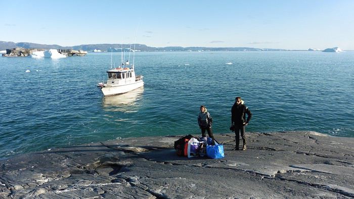
Here we were on the island, in the middle of nowhere, with all our luggage and food to organize, the tent to set up, and the kayaks to inflate—just 10 hours after leaving the Copenhagen hotel. We got to work, bothered by the flies. Despite our head nets, it was barely tolerable—there were so many of them. They swarmed by the dozens into every bag we opened. It was quite mild: 10°C.
Everything was ready by evening, and we were very happy to have completed all these transfers (planes and boat in a single day) as we slipped into our sleeping bags.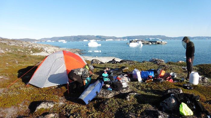
During the night, the wind picked up, and we went out several times to check the tent and kayak anchors. We noticed how bright it was—it was still quite twilight even at 1 AM.
Day 2 5:30 AM wake-up—the south wind was still strong, but since we were heading north, we decided to give it a try anyway.
This was also the moment we loaded the kayaks: since there were only three of us for two double-seater kayaks, we filled the hatch of one kayak, which allowed us to fit all our food. It would have been very difficult if there had been four of us for two kayaks.
Finally, we set off north along the western coast of the island. The conditions were far from ideal—the sea was rough, and the kayaks had a lot of wind resistance. But the main problem was the spray skirt: the gear on deck weighed it down, and the skirt kept coming off… We’d have to deal with it. Barely underway, and whales were already breaking the surface—it was our first time seeing them, and we were very impressed. Too bad the wind didn’t allow for longer contemplation; stopping paddling was impossible with such strong gusts.
We passed a few headlands and even considered stopping due to the conditions. To find some semblance of shelter, we had to hug the coast closely without cutting across the numerous bays, which significantly lengthened the journey. But as the morning went on, the wind died down, and the sea calmed. We spotted several whales and our first seals. It was almost pleasant during the picnic break. By late afternoon, we reached Kangerup Sarqâ Bay, where we had identified a great campsite with a very large beach and a river. But the wind had shifted—it was now coming from the north, making the last hour difficult due to fatigue and headwinds.
The campsite was ideal and beautiful, facing numerous icebergs grounded in the bay.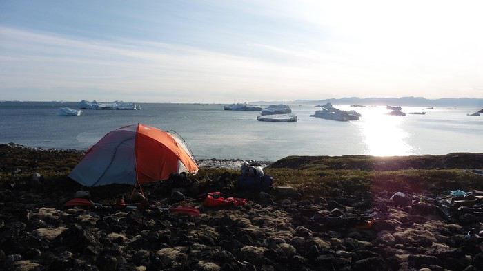
The GPS alerted us to another major drawback of inflatable kayaks: their slowness. It took us 7.5 hours of actual paddling (excluding breaks) to cover 28 km, averaging 3.7 km/h—somewhat disappointing. But we knew this before leaving, and once again, we’d have to make do!
Day 3 Surprise: at 6 AM wake-up, it was raining, foggy, with a south wind, and the sea was choppy even in the bay. It seemed wise to skip paddling, even though stopping on the second day was tough on morale. We went back to sleep, especially since the travel fatigue and the harsh conditions of the previous day had taken their toll.
At 11 AM, the navigation conditions weren’t any better—at the ends of the bay, we saw huge waves crashing onto the rocks, and giving up for the day became obvious. However, the rain had stopped, so we set off for a hike along the large lake bordering the bay. The wind hadn’t let up, and it was quite cold.
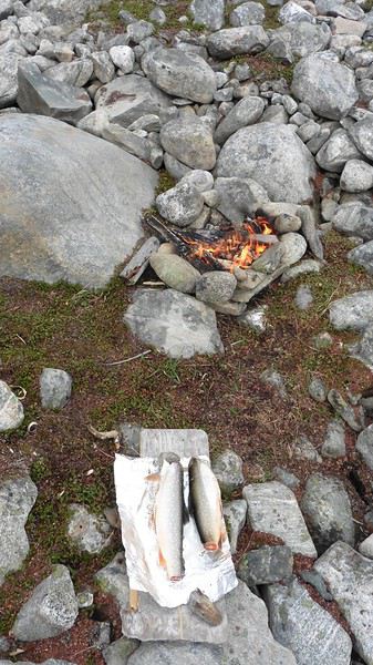
The tundra was starting to take on its autumn colors, and the contrast between the white lichens and the red vegetation was stunning. At the lake, we took out the fishing rods and quickly caught two beautiful Arctic char over 50 cm long.
As the afternoon wore on, the sun seemed closer. Along the beach, we gathered driftwood (mostly old planks) to cook our catch in foil over a fire. Eating our own food in such a beautiful place next to a good fire was comforting after the day’s setback.
In the middle of the night, an Arctic fox entered the tent’s rear awning. It seemed barely intimidated when we shooed it away with loud shouts and then with stones.
Day 4 6:15 AM wake-up—3°C. We were on the water by 8 AM. The wind had dropped significantly, but the sea was shrouded in fog, and it was very cold in these damp conditions.
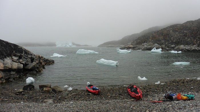
We passed the bay’s headland, Kangea, and headed toward the abandoned village of Agpat. The atmosphere was very austere—we hugged black rocks in fog that limited visibility to 50 meters, revealing large icebergs as we went.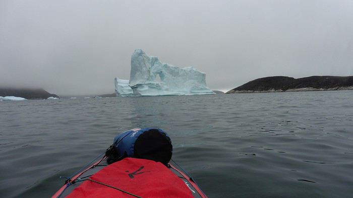
Suddenly, the water’s surface stirred in front of my kayak, and a huge gray back emerged from the sea. The collision was inevitable, but the whale seemed to understand and dove immediately, passing under the kayak and resurfacing a few meters away. I felt the kayak rock in the white foam and quickly paddled to escape the turbulence. What an emotion!
A light wind began to clear the fog, and the sun made beautiful appearances. Despite the cold, we stopped to visit the abandoned village, which left a strange impression. All the houses were still in good condition and wide open—some must have been very spacious in their time. We went back to sea, and in front of the large Kaangerdluk Bay, we hesitated—the headwind was strong, and large waves split the water. The next beach, from the island of Nua where we stopped to think, was over 8 km away. It was barely 2 PM, but caution led us to stop here for the day. We had covered 12 km—exactly the distance needed to stay on schedule. The afternoon was spent hiking on the island’s hills and gathering mussels and wood.
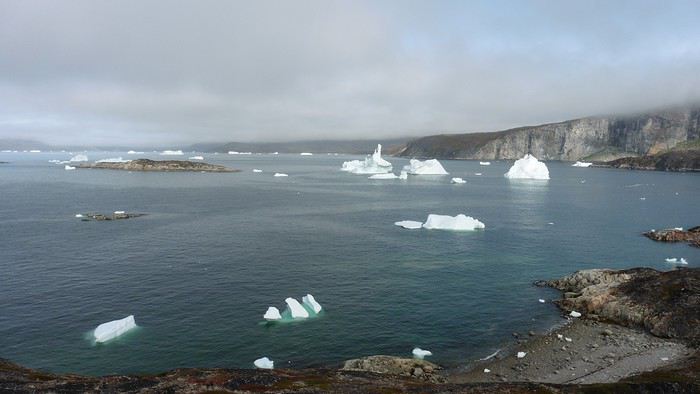
In the evening, we cooked these large Greenlandic mussels over a wood fire and savored them under the beautiful evening light. The weather was now fine, but the thermometer read -5°C in the sun…
Day 5 Bright sunshine, a glassy sea, and -8°C at 6 AM. Everything was green for setting off, even if putting on damp kayaking gear was a bit unpleasant in the cold. It was the first time we’d paddled on a flat sea since the start of the trip, and our average speed increased slightly.
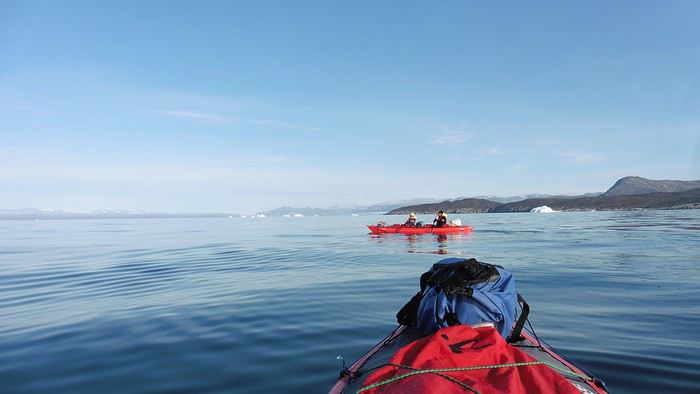
We entered the Smallesund Strait, marking the end of the island’s west coast. We were close to the large Torssukatak Fjord, where two glaciers flow. The access pass to the fjord was very narrow, and numerous ice chunks blocked access to the beaches. The wind had picked up and was now hitting us head-on (again). Just before entering the fjord, we landed on a steep beach made of large pebbles on Oqaitsut Island. It was very cold with the wind, and moving forward became difficult. We decided to stop for the day both because of the conditions and because the next campsite was far away, given how rugged the fjord was.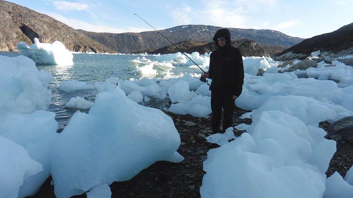
We eventually found a flat spot for the tent despite the steep slope. Even with the wind, the weather was beautiful, and we set off on foot for the northeastern cape of the island, overlooking the fjord. The view was far-reaching and exceptional—up close, the large fjord filled with ice and its steep granite cliffs, and in the distance, the ice cap and glacial walls.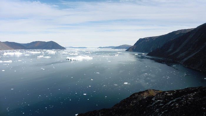
We spotted the village of Qeqertaq, whose network we could pick up, allowing us to check the weather forecast, which was rather good. While securing the kayaks in the evening, I noticed the strange behavior of one kayak at the end of the stage was due to the loss of the skeg—impossible to know where it detached. We’d have to do without it.
Day 6 Still that icy headwind from the northeast. We set off anyway for a long stage to reach the large pass connecting the Torssukatak and Ata Fjords.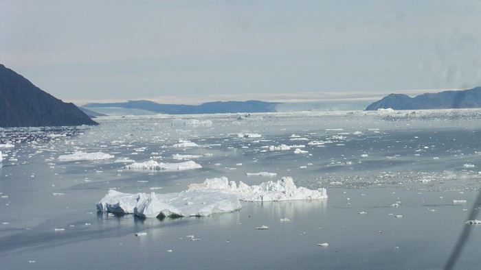
We advanced laboriously along the high cliffs of the fjord’s southern shore. They faced due north and blocked the sun. We felt the cold and dampness of the rock. It was really cold, especially in the extremities. We picnicked on the western cape of Qeqertakavasak Island. The cold didn’t allow us to stop for more than 20 minutes… But the wind dropped, and the sea was now very smooth. It was heavily cluttered with ice between the icebergs and old pack ice. The goal was to reach the large rocky promontory of Anapnuna, wedged between the Kujatdleq and Kangilerngata Glaciers, but the ice made progress difficult. We stopped to gain height on a small island and spot a passage of open water, but all we saw was white—passing seemed impossible. The currents were very complex, and entire sections of ice were being swept in one direction and then another at an impressive speed.
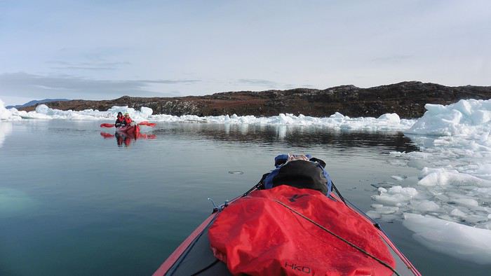
We wandered through this labyrinth until landing on a beach on the small island of Takissut, where we set up camp, exhausted from the 30 km covered and the vigilance required by the abundance of ice. The place was sublime under the evening sun—we were surrounded by ice and mountains, with the Kangilerngata Glacier in the distance. The summer contrasts were striking between the water, icebergs, sky, and flaming tundra—all colors were represented. Absolute calm reigned.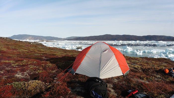
The lack of drinking water at this spot wasn’t too much of a constraint: as soon as we arrived on the beach, we placed containers under the icebergs stranded in the intertidal zone. They were all full by the time we finished setting up.
Day 7 We had to change our plans: we wouldn’t reach the rocky promontory, too well protected by the ice. We set off under the sun for Igdluluarssuit Island. Although we had spotted a passage just before launching, we quickly found ourselves surrounded by ice. It was everywhere, and finding water to paddle became complicated. We tried to force our way in every direction, even retracing our steps. Everything moved at an impressive speed—we were in the middle of a whirlpool of ice.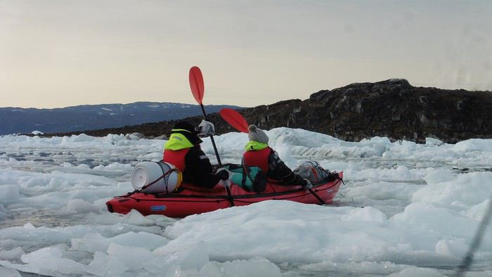
The tension rose, and each boat had its share of big scares. I was trapped against ice floes that dragged me toward an iceberg—the pressure on the kayak was enormous; it was going to capsize or puncture! But with a few strong strokes and paddling against the ice, I managed to free myself from the trap. Barely 10 minutes later, my companions were sandwiched perpendicularly between two icebergs that were closing in. The situation was desperate—the kayak was bending and twisting more and more, but with some strong paddle strokes, it finally freed itself. After these particularly unpleasant moments, we were completely blocked. The drifting ice floes had tightened, and the kayaks were no longer even in the water… The only solution: wait with the kayaks on these floes, which were too thin to walk on (even though we didn’t try). Within minutes, the situation cleared—a waterway opened, and we rushed into it. We paddled with one goal: find a larger pool of water. After going back and forth, our path took shape—we had to force the passage several times, attacking the ice directly with the kayaks, and finally, we escaped the worst of the labyrinth. We reached land on the west side of the island and saw that the rest would be easier. To reach the island, we just had to cross the Arsiviup Ikera Strait, which was lightly cluttered. We reached the eastern cape of the island, ideal for camping, even though we had only paddled for 3 hours. We set up camp and hiked to the island’s summit, which overlooks the entire pass and the glaciers.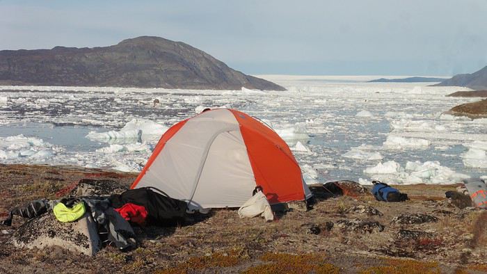
Everything was magnificent, no matter the direction. At 2 PM, we were at the summit—the beauty of the place and the picnic facing the glacier in the sun without wind made us forget the near-disaster from a few hours earlier. It would be impossible to approach the glacier by kayak, but from our summit on foot, it seemed so close, and contemplating it safely on solid ground was a great moment.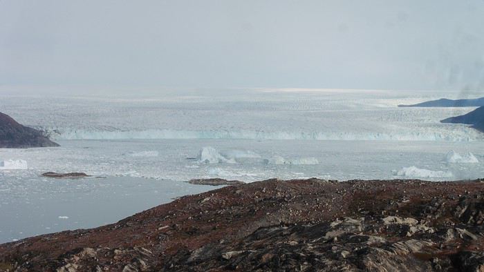
The pass was incredibly complex—everything was in motion, and an impassable passage could become open water within minutes. We were delighted when we returned to camp. A slightly lost whale among the ice accompanied us along the shore. The place was truly beautiful, but the temperature dropped again under the clear sky, preventing us from eating outside.
Day 8 Clear and cold at wake-up: -9°C. The sea had frozen in many places. We hesitated about the rest of the trip—should we start heading back to Ilulissat or linger in the pass, especially to approach the Eqi Glacier? After the incidents of the previous day, we decided to think carefully and paddled to the southern cape of our island to check the ice conditions toward Eqi. The weather had clouded over in the meantime, and the sky was quite gray. At the cape, we spotted the glacier’s wall, still 15 km away.
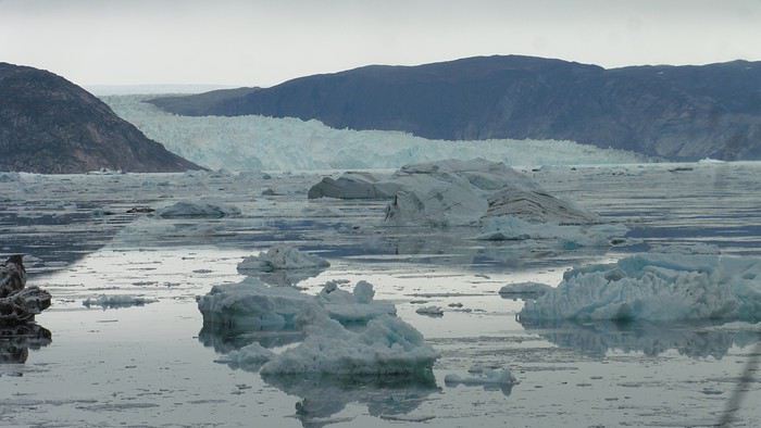
The fjord was quite cluttered, but it seemed passable. However, there was no guarantee the view would be much better 1 km from the glacier than 15 km away, especially since the front was quite active and therefore dangerous. We decided to head south without passing by the glacier. The cold temperatures encountered in the pass also motivated us to move away from the glaciers and the ice cap. We navigated under a threatening sky but without wind. The kayaks cut through the thin layer of ice on the surface with a crinkling paper sound. We reached the Ata campsite in the late afternoon after 5 hours of rowing without a single break…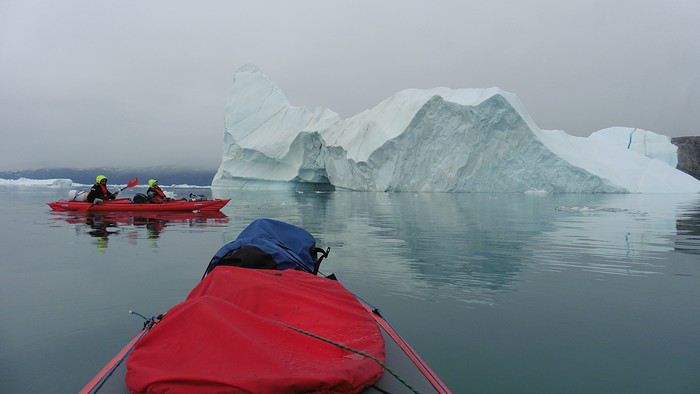
The wind had picked up, and we discovered a nice surprise: a refuge with a table and a comfortable bench lined with mattresses. Facing the worsening weather, we settled in comfortably. The kerosene stove was too complex for our three brains—we couldn’t get it started, too bad, as it was 0°C inside. The rest of the afternoon was spent fishing in the large lake, where we landed a beautiful Arctic char, more than enough for three. A good night’s sleep without the risk of foxes or the sound of a tent shaking in the wind.
Day 9 6 AM wake-up to the sound of rain hitting the cabin. The decision was made looking out the window—wind, rain, and fog obscured the sea: we went back to sleep.
New wake-up, and the rain had stopped—we could go out and stock up on fish. We set off on foot toward the lake, following its western shore. It was very overcast, and the wind encouraged us to keep moving. We made our way to a smaller lake at the end of the large one, where we caught a huge Arctic char. A small clearing brightened the picnic, and we headed back to our cabin.
This 20 km hike kept us busy all day: walking on slippery scree and the micro-relief of the peat bogs took time.
Day 10 The sky was clear, but a light south wind made paddling intense. We set off southeast to reach the opposite shore of the fjord. It was very cold, and it was impossible to stop paddling for even a moment without immediately losing ground due to the wind. We crossed the Kangerluarsuk Fjord. I recognized the cape I had reached on skis in the winter of 2017. We found a nice campsite on the southern shore of the fjord: Uiartag. It wasn’t even noon, but facing this headwind, we preferred to stop here rather than exhaust ourselves for a few extra kilometers. Like the previous ones, this campsite was very comfortable: the ground was covered with a thick layer of lichens and mosses, very pleasant to lie on.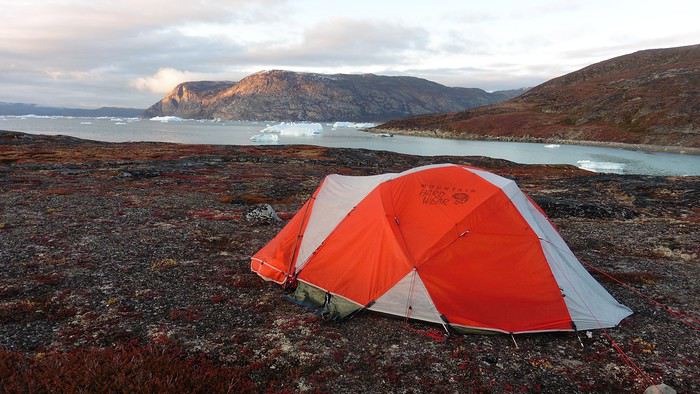
We set off on a hike to the heights of the cape, where the weather alternated between large clearings and snow showers. We noticed the loss of the thermometer, poorly attached to the backpack. On the way back, in the small bay of our beach, a whale swam calmly 10 meters from the shore—a beautiful surprise.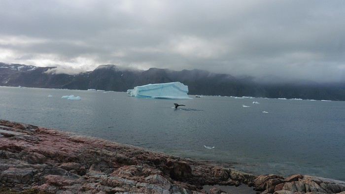
The sky cleared completely, and the temperature dropped as night approached.
We’re setting off as a group of three in two inflatable double-seater kayaks (Gumotex) brought from France. The plan is to spend two weeks circumnavigating Arve Princess Island, located north of Ilulissat in Disko Bay, with a possible boat drop-off at the southern tip of the island.
This seems like a fairly classic route in the area—we found several descriptions online (thanks to the authors). With their help and Google Earth, we identified all potential campsites and entered their coordinates into a GPS. The western part of the island, facing the bay, seems ideal for whale watching, while the more rugged eastern side offers access to several glacial walls. We’re somewhat familiar with the area from two winter expeditions on skis and pulkas.
Plus, the commitment is limited due to the island’s proximity to several small villages, including Qeqertaq, Oqaatsut, and even Ilulissat. In fact, we saw fishing boats almost every day. The distance suits us well: 200 kilometers in 16 full days on site, which should leave some leeway in case of bad weather or for hiking.
We booked our flights in June with Air Greenland to Ilulissat for the last week of August and the first week of September. On both the outbound and return trips, we stayed overnight in Copenhagen. The France-Copenhagen flight was with Air France.
We were allowed 3 x 20 kg in the hold. Each kayak with its accessories fits into a 20 kg bag; the last hold bag is for shared gear: tent, stoves, dry bags… We only brought 1.5 kg of semolina for food. In the end, we had 61 kg of gear, and no excess baggage was charged.
Individual gear (clothes and sleeping bags…) was distributed in the cabin luggage.
For the boat transfer, we contacted an agency: Blue Jay, which gave us a number to call upon arrival.
Day 0: Wednesday, August 22 Departure day. After work, I drove from Gap to Marseille’s Marignane Airport for the first leg of the trip to Copenhagen. I enjoyed the rather mild local temperatures: 35°C in the shade. After a layover in Paris, I arrived at the Copenhagen hotel, located two train stops from the airport, where my companions were already settled. No issues—everyone was on time with their luggage.
Day 1 The flight to Greenland was at 9 AM. We had a layover in Kangerlussuaq, where we changed planes, then stopped in Aasiaat before reaching Ilulissat Airport at 3 PM under beautiful sunshine.
We called Blue Jay for the boat transfer: they could take us to the island as early as 6 PM; otherwise, we’d have to wait until the next day. That left us 3 hours to prepare our gear and, most importantly, do our shopping for the two-week trip—it seemed tight, but we gave it a shot.
A quick taxi ride took us to Pisiffik, where we easily found everything we needed: bread, butter, cheese, cold cuts, rice, pasta, jam, muesli… There was no C fuel or methylated spirits for the stoves, but this time we knew the trick: at Stark, a bit uphill from the town, we found the precious liquids. Two hours later, we filled our dry bags and containers with our purchases, and by 5:30 PM, we met Klaus, the Blue Jay manager, directly at the port.
The vacation seemed to truly begin as we sped by boat through the icebergs toward Arve Princess Island. Forty-five minutes later, we spotted a beach lined with rocks where Klaus dropped us off quickly (he had another transfer to make right after).
Here we were on the island, in the middle of nowhere, with all our luggage and food to organize, the tent to set up, and the kayaks to inflate—just 10 hours after leaving the Copenhagen hotel. We got to work, bothered by the flies. Despite our head nets, it was barely tolerable—there were so many of them. They swarmed by the dozens into every bag we opened. It was quite mild: 10°C.
Everything was ready by evening, and we were very happy to have completed all these transfers (planes and boat in a single day) as we slipped into our sleeping bags.
During the night, the wind picked up, and we went out several times to check the tent and kayak anchors. We noticed how bright it was—it was still quite twilight even at 1 AM.
Day 2 5:30 AM wake-up—the south wind was still strong, but since we were heading north, we decided to give it a try anyway.
This was also the moment we loaded the kayaks: since there were only three of us for two double-seater kayaks, we filled the hatch of one kayak, which allowed us to fit all our food. It would have been very difficult if there had been four of us for two kayaks.
Finally, we set off north along the western coast of the island. The conditions were far from ideal—the sea was rough, and the kayaks had a lot of wind resistance. But the main problem was the spray skirt: the gear on deck weighed it down, and the skirt kept coming off… We’d have to deal with it. Barely underway, and whales were already breaking the surface—it was our first time seeing them, and we were very impressed. Too bad the wind didn’t allow for longer contemplation; stopping paddling was impossible with such strong gusts.
We passed a few headlands and even considered stopping due to the conditions. To find some semblance of shelter, we had to hug the coast closely without cutting across the numerous bays, which significantly lengthened the journey. But as the morning went on, the wind died down, and the sea calmed. We spotted several whales and our first seals. It was almost pleasant during the picnic break. By late afternoon, we reached Kangerup Sarqâ Bay, where we had identified a great campsite with a very large beach and a river. But the wind had shifted—it was now coming from the north, making the last hour difficult due to fatigue and headwinds.
The campsite was ideal and beautiful, facing numerous icebergs grounded in the bay.
The GPS alerted us to another major drawback of inflatable kayaks: their slowness. It took us 7.5 hours of actual paddling (excluding breaks) to cover 28 km, averaging 3.7 km/h—somewhat disappointing. But we knew this before leaving, and once again, we’d have to make do!
Day 3 Surprise: at 6 AM wake-up, it was raining, foggy, with a south wind, and the sea was choppy even in the bay. It seemed wise to skip paddling, even though stopping on the second day was tough on morale. We went back to sleep, especially since the travel fatigue and the harsh conditions of the previous day had taken their toll.
At 11 AM, the navigation conditions weren’t any better—at the ends of the bay, we saw huge waves crashing onto the rocks, and giving up for the day became obvious. However, the rain had stopped, so we set off for a hike along the large lake bordering the bay. The wind hadn’t let up, and it was quite cold.
The tundra was starting to take on its autumn colors, and the contrast between the white lichens and the red vegetation was stunning. At the lake, we took out the fishing rods and quickly caught two beautiful Arctic char over 50 cm long.
As the afternoon wore on, the sun seemed closer. Along the beach, we gathered driftwood (mostly old planks) to cook our catch in foil over a fire. Eating our own food in such a beautiful place next to a good fire was comforting after the day’s setback.
In the middle of the night, an Arctic fox entered the tent’s rear awning. It seemed barely intimidated when we shooed it away with loud shouts and then with stones.
Day 4 6:15 AM wake-up—3°C. We were on the water by 8 AM. The wind had dropped significantly, but the sea was shrouded in fog, and it was very cold in these damp conditions.
We passed the bay’s headland, Kangea, and headed toward the abandoned village of Agpat. The atmosphere was very austere—we hugged black rocks in fog that limited visibility to 50 meters, revealing large icebergs as we went.
Suddenly, the water’s surface stirred in front of my kayak, and a huge gray back emerged from the sea. The collision was inevitable, but the whale seemed to understand and dove immediately, passing under the kayak and resurfacing a few meters away. I felt the kayak rock in the white foam and quickly paddled to escape the turbulence. What an emotion!
A light wind began to clear the fog, and the sun made beautiful appearances. Despite the cold, we stopped to visit the abandoned village, which left a strange impression. All the houses were still in good condition and wide open—some must have been very spacious in their time. We went back to sea, and in front of the large Kaangerdluk Bay, we hesitated—the headwind was strong, and large waves split the water. The next beach, from the island of Nua where we stopped to think, was over 8 km away. It was barely 2 PM, but caution led us to stop here for the day. We had covered 12 km—exactly the distance needed to stay on schedule. The afternoon was spent hiking on the island’s hills and gathering mussels and wood.
In the evening, we cooked these large Greenlandic mussels over a wood fire and savored them under the beautiful evening light. The weather was now fine, but the thermometer read -5°C in the sun…
Day 5 Bright sunshine, a glassy sea, and -8°C at 6 AM. Everything was green for setting off, even if putting on damp kayaking gear was a bit unpleasant in the cold. It was the first time we’d paddled on a flat sea since the start of the trip, and our average speed increased slightly.
We entered the Smallesund Strait, marking the end of the island’s west coast. We were close to the large Torssukatak Fjord, where two glaciers flow. The access pass to the fjord was very narrow, and numerous ice chunks blocked access to the beaches. The wind had picked up and was now hitting us head-on (again). Just before entering the fjord, we landed on a steep beach made of large pebbles on Oqaitsut Island. It was very cold with the wind, and moving forward became difficult. We decided to stop for the day both because of the conditions and because the next campsite was far away, given how rugged the fjord was.
We eventually found a flat spot for the tent despite the steep slope. Even with the wind, the weather was beautiful, and we set off on foot for the northeastern cape of the island, overlooking the fjord. The view was far-reaching and exceptional—up close, the large fjord filled with ice and its steep granite cliffs, and in the distance, the ice cap and glacial walls.
We spotted the village of Qeqertaq, whose network we could pick up, allowing us to check the weather forecast, which was rather good. While securing the kayaks in the evening, I noticed the strange behavior of one kayak at the end of the stage was due to the loss of the skeg—impossible to know where it detached. We’d have to do without it.
Day 6 Still that icy headwind from the northeast. We set off anyway for a long stage to reach the large pass connecting the Torssukatak and Ata Fjords.
We advanced laboriously along the high cliffs of the fjord’s southern shore. They faced due north and blocked the sun. We felt the cold and dampness of the rock. It was really cold, especially in the extremities. We picnicked on the western cape of Qeqertakavasak Island. The cold didn’t allow us to stop for more than 20 minutes… But the wind dropped, and the sea was now very smooth. It was heavily cluttered with ice between the icebergs and old pack ice. The goal was to reach the large rocky promontory of Anapnuna, wedged between the Kujatdleq and Kangilerngata Glaciers, but the ice made progress difficult. We stopped to gain height on a small island and spot a passage of open water, but all we saw was white—passing seemed impossible. The currents were very complex, and entire sections of ice were being swept in one direction and then another at an impressive speed.
We wandered through this labyrinth until landing on a beach on the small island of Takissut, where we set up camp, exhausted from the 30 km covered and the vigilance required by the abundance of ice. The place was sublime under the evening sun—we were surrounded by ice and mountains, with the Kangilerngata Glacier in the distance. The summer contrasts were striking between the water, icebergs, sky, and flaming tundra—all colors were represented. Absolute calm reigned.
The lack of drinking water at this spot wasn’t too much of a constraint: as soon as we arrived on the beach, we placed containers under the icebergs stranded in the intertidal zone. They were all full by the time we finished setting up.
Day 7 We had to change our plans: we wouldn’t reach the rocky promontory, too well protected by the ice. We set off under the sun for Igdluluarssuit Island. Although we had spotted a passage just before launching, we quickly found ourselves surrounded by ice. It was everywhere, and finding water to paddle became complicated. We tried to force our way in every direction, even retracing our steps. Everything moved at an impressive speed—we were in the middle of a whirlpool of ice.
The tension rose, and each boat had its share of big scares. I was trapped against ice floes that dragged me toward an iceberg—the pressure on the kayak was enormous; it was going to capsize or puncture! But with a few strong strokes and paddling against the ice, I managed to free myself from the trap. Barely 10 minutes later, my companions were sandwiched perpendicularly between two icebergs that were closing in. The situation was desperate—the kayak was bending and twisting more and more, but with some strong paddle strokes, it finally freed itself. After these particularly unpleasant moments, we were completely blocked. The drifting ice floes had tightened, and the kayaks were no longer even in the water… The only solution: wait with the kayaks on these floes, which were too thin to walk on (even though we didn’t try). Within minutes, the situation cleared—a waterway opened, and we rushed into it. We paddled with one goal: find a larger pool of water. After going back and forth, our path took shape—we had to force the passage several times, attacking the ice directly with the kayaks, and finally, we escaped the worst of the labyrinth. We reached land on the west side of the island and saw that the rest would be easier. To reach the island, we just had to cross the Arsiviup Ikera Strait, which was lightly cluttered. We reached the eastern cape of the island, ideal for camping, even though we had only paddled for 3 hours. We set up camp and hiked to the island’s summit, which overlooks the entire pass and the glaciers.
Everything was magnificent, no matter the direction. At 2 PM, we were at the summit—the beauty of the place and the picnic facing the glacier in the sun without wind made us forget the near-disaster from a few hours earlier. It would be impossible to approach the glacier by kayak, but from our summit on foot, it seemed so close, and contemplating it safely on solid ground was a great moment.
The pass was incredibly complex—everything was in motion, and an impassable passage could become open water within minutes. We were delighted when we returned to camp. A slightly lost whale among the ice accompanied us along the shore. The place was truly beautiful, but the temperature dropped again under the clear sky, preventing us from eating outside.
Day 8 Clear and cold at wake-up: -9°C. The sea had frozen in many places. We hesitated about the rest of the trip—should we start heading back to Ilulissat or linger in the pass, especially to approach the Eqi Glacier? After the incidents of the previous day, we decided to think carefully and paddled to the southern cape of our island to check the ice conditions toward Eqi. The weather had clouded over in the meantime, and the sky was quite gray. At the cape, we spotted the glacier’s wall, still 15 km away.
The fjord was quite cluttered, but it seemed passable. However, there was no guarantee the view would be much better 1 km from the glacier than 15 km away, especially since the front was quite active and therefore dangerous. We decided to head south without passing by the glacier. The cold temperatures encountered in the pass also motivated us to move away from the glaciers and the ice cap. We navigated under a threatening sky but without wind. The kayaks cut through the thin layer of ice on the surface with a crinkling paper sound. We reached the Ata campsite in the late afternoon after 5 hours of rowing without a single break…
The wind had picked up, and we discovered a nice surprise: a refuge with a table and a comfortable bench lined with mattresses. Facing the worsening weather, we settled in comfortably. The kerosene stove was too complex for our three brains—we couldn’t get it started, too bad, as it was 0°C inside. The rest of the afternoon was spent fishing in the large lake, where we landed a beautiful Arctic char, more than enough for three. A good night’s sleep without the risk of foxes or the sound of a tent shaking in the wind.
Day 9 6 AM wake-up to the sound of rain hitting the cabin. The decision was made looking out the window—wind, rain, and fog obscured the sea: we went back to sleep.
New wake-up, and the rain had stopped—we could go out and stock up on fish. We set off on foot toward the lake, following its western shore. It was very overcast, and the wind encouraged us to keep moving. We made our way to a smaller lake at the end of the large one, where we caught a huge Arctic char. A small clearing brightened the picnic, and we headed back to our cabin.
This 20 km hike kept us busy all day: walking on slippery scree and the micro-relief of the peat bogs took time.
Day 10 The sky was clear, but a light south wind made paddling intense. We set off southeast to reach the opposite shore of the fjord. It was very cold, and it was impossible to stop paddling for even a moment without immediately losing ground due to the wind. We crossed the Kangerluarsuk Fjord. I recognized the cape I had reached on skis in the winter of 2017. We found a nice campsite on the southern shore of the fjord: Uiartag. It wasn’t even noon, but facing this headwind, we preferred to stop here rather than exhaust ourselves for a few extra kilometers. Like the previous ones, this campsite was very comfortable: the ground was covered with a thick layer of lichens and mosses, very pleasant to lie on.
We set off on a hike to the heights of the cape, where the weather alternated between large clearings and snow showers. We noticed the loss of the thermometer, poorly attached to the backpack. On the way back, in the small bay of our beach, a whale swam calmly 10 meters from the shore—a beautiful surprise.
The sky cleared completely, and the temperature dropped as night approached.
Partis avec des à-priori mais revenus enchantés du Vietnam English translation pending
ITINERAIRE
Bonjour, Comme dit dans le titre , c'est un pays que j'appréhendais pas mal , à cause de lectures relatant des déconvenues et arnaques. Mais finalement après avoir voyagé en Thailande , au Laos , au Cambodge et en Birmanie , on s'est décidé pour le Vietnam ...et on est revenus éblouis et ravis .
Voyage effectué du 8 mai au 7 juin dernier , à 2 couples de seniors . itinéraire :
- Vol Nantes- Bangkok via Amsterdam sur KLM ( 1 nuit à BKK) - Vol BKK- Hanoi avec air Asia ( 3 nuits à Hanoi) - Croisière en baie d'Halong ( 1 nuit sur la jonque ) - Tam Coc ( 3 nuits ) - Sapa ( 1 nuit ) - Bac Ha ( 2 nuits ) - Ha Giang ( 1 nuit ) - Dong Van ( 2 n ) - Bao Lac ( 1 n ) - Cao Bang ( 2 n ) - Hanoi ( 1 n ) - vol de Hanoi à Hué ( 2 n ) - Hoi An ( 3 n ) - plage de An Bang ( 4 n ) - Vol de danang à BKK ( 2 n ) Vol BKK- nantes via Amsterdam
Je peux évidemment détailler ce périple si de futurs voyageurs sont intéressés. J'ai tout organisé par moi-même pour l'essentiel . Larsay m'a aidée à trouver un véhicule avec chauffeur anglophone pour la boucle nord de 10 jours en partant de Tam Coc et en finissant à Hanoi . En ce moment , on est dans le tri des photos et des montages vidéos , ce qui nous permet de continuer visuellement ce magnifique voyage . la météo que j'appréhendais a été très favorable ....( très chaude même )
je suis donc prête à mon tour à aider des forumeurs intéressés.
Cordialement
à suivre éventuellement...
Bonjour, Comme dit dans le titre , c'est un pays que j'appréhendais pas mal , à cause de lectures relatant des déconvenues et arnaques. Mais finalement après avoir voyagé en Thailande , au Laos , au Cambodge et en Birmanie , on s'est décidé pour le Vietnam ...et on est revenus éblouis et ravis .
Voyage effectué du 8 mai au 7 juin dernier , à 2 couples de seniors . itinéraire :
- Vol Nantes- Bangkok via Amsterdam sur KLM ( 1 nuit à BKK) - Vol BKK- Hanoi avec air Asia ( 3 nuits à Hanoi) - Croisière en baie d'Halong ( 1 nuit sur la jonque ) - Tam Coc ( 3 nuits ) - Sapa ( 1 nuit ) - Bac Ha ( 2 nuits ) - Ha Giang ( 1 nuit ) - Dong Van ( 2 n ) - Bao Lac ( 1 n ) - Cao Bang ( 2 n ) - Hanoi ( 1 n ) - vol de Hanoi à Hué ( 2 n ) - Hoi An ( 3 n ) - plage de An Bang ( 4 n ) - Vol de danang à BKK ( 2 n ) Vol BKK- nantes via Amsterdam
Je peux évidemment détailler ce périple si de futurs voyageurs sont intéressés. J'ai tout organisé par moi-même pour l'essentiel . Larsay m'a aidée à trouver un véhicule avec chauffeur anglophone pour la boucle nord de 10 jours en partant de Tam Coc et en finissant à Hanoi . En ce moment , on est dans le tri des photos et des montages vidéos , ce qui nous permet de continuer visuellement ce magnifique voyage . la météo que j'appréhendais a été très favorable ....( très chaude même )
je suis donc prête à mon tour à aider des forumeurs intéressés.
Cordialement
à suivre éventuellement...
Sortir des sentiers battus au Sulawesi English translation pending
Ayant découvert le sulawesi il y a 4 ans j y retourne mais cette fois je vais essayer de sortir des sentiers battus .. je connais déjà toraja , manado , bunaken , lembey .... cette fois ci j aimerai passer une semaine avec le peuple badjo et aller pêcher avec eux , je retourne passer une semaine au pays toraja pour sûre , je vais me rendre aussi à malenge ( Togian ) je compte aussi découvrir le sud est ( wakatobi ) et d autres coins non touriste mais mais qui ont été des coups de cœur pour vous car je ne parvient pas à trouver trop d infos hormis sur les endroits que je connais déjà .. si quelqu un a des infos ce serrait au top car j y serais le 3 juillet 2018 .. je suis preneur de toute idée et bons plans ... merci d avance à tous ..
New York vue depuis la baie et ESTA English translation pending
bonjour
suite à la lecture de carnets de voyage de ces chers voyageurs/forumeurs, je voudrais savoir s'il existe des sorties en bateau pour découvrir la ville et ses environs depuis la bay
apparemment certains ont fait des "croisières" ou sorties trop longues ou trop "usines"
et 2ème petite question (mais je pense que je trouverai la réponse !) l'est est valable combien de temps si on est déjà allé aux EU avec?
merci
anne
Idée d'itinéraire au Vietnam avec enfants English translation pending
Bonjour,
je recherche des idées d'itinéraires et des endroits sympas ou loger pas cher au vietnam. nous partons environ 2 semaines et demi. nous arriverons par ho chi minh. nous souhaitons aller vers la baie d'Along (incontournable 😉) et Hué. nous souhaitons également faire quelques jours de plages avec les enfants (10 mois et 5 ans)
concernant les questions diverses, est ce que l'on trouve tout ce qu'il faut pour bébé (couches, petits pots, lait en poudre...) les hôtels sont ils équipés de lit bébé ou est ce qu'il est facile de trouver un lit nomade sur place en arrivant ?
merci à tous de vos partages de bons plans et d'idées d'itinéraires baud
je recherche des idées d'itinéraires et des endroits sympas ou loger pas cher au vietnam. nous partons environ 2 semaines et demi. nous arriverons par ho chi minh. nous souhaitons aller vers la baie d'Along (incontournable 😉) et Hué. nous souhaitons également faire quelques jours de plages avec les enfants (10 mois et 5 ans)
concernant les questions diverses, est ce que l'on trouve tout ce qu'il faut pour bébé (couches, petits pots, lait en poudre...) les hôtels sont ils équipés de lit bébé ou est ce qu'il est facile de trouver un lit nomade sur place en arrivant ?
merci à tous de vos partages de bons plans et d'idées d'itinéraires baud
Sainte-Rose ou Baie Mahault pour découvrir Basse-Terre English translation pending
Bonsoir,
Je pars dans 3 semaines en Guadeloupe et n’ai pas encore réservé de logement..
Et comme qu’il s’agit de la haute saison, le choix est donc limité.
J’ai trouvé des logements chez l’habitant/ chambre d’hotes à Sainte Rose ou Baie Mahault.
Quel est l’endroit le plus stratégique (pour faire moins de route possible et éviter les embouteillages) pour visiter Basse Terre?
Merci.
Aude