J'aimerais bien combiner les treks Helambu et Langtang à partir de Katmadou.
Pour ce faire, j'ai besoin de connaître le dénivelé entre Kyanjin Gompa qui semble être la fin "habituelle" du trek Langtang (corrigez-moi si je me trompe) et Langshisha Kharka qui semble être une "extension" de l'habituel trek du Langtang en direction de l'Est.
Certaines cartes semblent montrer la possibilité de continuer de Kyanjin Gompa jusqu'à Langshisha Kharka, mais je n'ai aucune idée à quoi m'attendre sauf qu'il semble ne pas y avoir ni lodge ni ravitaillement en nourriture possible. Je n'ai aucune idée de la distance aller-retour non plus...
Quand nous seront dans les environs, nous aimerions traverser le col du Ganga La pour ainsi nous retrouver illico plus au Sud, éviter de faire/voir le même trajet de retour qu'à l'aller, et ainsi être tout près des pistes pour débuter le trek de l'Helambu.
Puisque les livres touristiques déconseillent vivement de faire la traversée du Ganga La sans guide, est-il farfelu de penser trouver un guide dans la vallée du langtang pour traverser le col? L'idée d'engager un guide à Katmandou pour cette courte portion (5 jours, je crois) du trajet me semble disproportionnée...
Un grand merci pour vos suggestions/commentaires.
Marc Lamarre, Montréal
La vie étant particulièrement imprévisible, vaut mieux manger son dessert en premier, et garder les navets pour la fin...
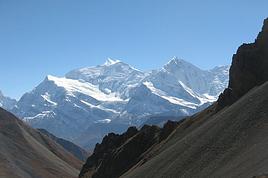
depuis Kyanging Gompa, c'est un itinéraire de vallée (élevée > 4.000 m) sans grande difficultés ... Nous avons fait un AR jusqu'à la moraine en vue de Langsisa Karak dans la journée sans Pb (superbe, fleurs, chevaux et yacks en liberté .... environnement vallée glaciare grandiose ...) Bref, à recommander et malgré la longueur (une grande journée quand même ...) inutile de prévoir le bivouac (pas de lodges bien sûr ...)
Pour le Ganja la, il faut prévoir au moins une nuit en altitude (camping) ... D'où l'infrastructure requise : emporter le matos de camping dès le départ ... D'où porteurs ... Pour le guide, je n'ai pas demandé sur place, mais tous les treks partant pour le col avaient leur propre matos (avec guide et porteurs en nombre !!!) - Bref, je me suis félicité, à Kyanging Gompa, d'avoir visé un AR sur le Langtang et un passage sur le sud et l'Hélambu via Gosainkund !! - Surtout que le jour où nous aurions dû partir sur le col, une méchante chute de neige avait sévi et rendu la chose aléatoire ...
A voir donc, et bon trek
Je n'avais pas vu la réponse ci dessus mais je te réponds brièvement : pour Langshisha Kharka, effectivement rien de rien comme ravitaillement, j'avais commencé un belle balade à cheval dans cette direction. Par rapport au reste du trek, c'est incroyablement PLAT !! Mais je dirai qu'en marchant bien, il faut une bonne journée pour faire l'A/R en partant tôt.
pour ce qui est de Ganga La, je n'y suis pas passé mais tous les Népalais présents à Kyanjin Gompa en parlaient comme un des passages de trek les + difficiles ! Disons qu'en isolement complet 5 jours, il suffit d'une dégradation climatique là-haut pour que ça puisse virer assez vite à la catastrophe. Je ne connais pas ton niveau, mais je réfléchirai à 2 fois à m'engager là-haut si c'est juste pour "gagner du temps". En plus, y'a largement de quoi faire un superbre trek en combinant Langtang et Gosainkund par la voie "normale", ie en redescendant un peu...
Voilà pour mon avis très personel, à chacun son opinion 😇
Bon trek
Julien
Le "trou du Q" du Népal en photos, en été et en hiver : MugHumla
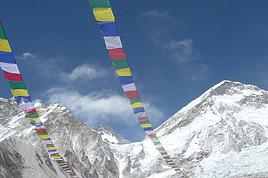
Langshisa Kharka c'est environ 4 heures et assez plat. Mais si tu es equippe pour le bivouac tu peux continuer 2 ou 3 heures plus loin au camp de base de je ne sais plus quoi, une superbe vallee d'ablation. La, cela monte. J'y ai campe en decembre dernier, -14 C le matin dans ma tente. Apres possible encore de continuer mais sur le glacier.
De Kianjin autre excursion le petit sommet 49xx m au dessus (aussi oublie le nom), il y a un sentier (meme 2, en fait, possible de faire un circuit dans la journee).
pour ceux connaissant ce parcours (langtang), est-il envisageable au mois de septembre ou bien la mousson y est-elle très gênante?
j'envisage ce trek en individuel avec une amie et nous voudrions avoir vos témoignages à ce sujet
merci d'avance
sportivement
Je peux t'envoyer la carte du langtang. Par contre pour la mousson....? J'y étais en décembre et janvier. Mais normalement ça ne devrait pas poser de gros problèmes.
Tu sais comment faire pour les permis? Les Checkpoint?
Si tu as envie de chouettes petits trucs pour le trek... je peux t'en donner ;-)
sur la partie supérieure (près Kyanging gompa - 3.900 m alt) et en Octobre on a eu une "petite" averse ... de neige, bien sûr avec l'altitude, ... et même punition qu'en montagne : dégradation très rapide, fermeture possible des cols, ascensions compromises etc ...
En Septembre, ça peut tourner rapidement au quasi-cauchemar si on est pas préparé ... au mini, à mon avis, ne pas se fixer des objectifs très élevés ... not. le passage du Ganja La ...
Bref, pendant la mousson, difficile ... à vous de voir ...
J'envisage de partir au Népal début mars, pour 3 semaines. Ce sera ma 2nde fois la bas et j'aurais aimé trekker du côté du Langtang (vallée du Langtang,…
Nous envisageons un trek dans la vallée du Langtang et lacs Gosainkud Départ Syabru Bensi Rimche Langtang Kiangjin Kompa avec ascension Kangjing Ri Lama hotel…
Je prévois de partir un trek dans la vallée du Langtang avec éventuellement l'ascension du Yala peak avec ma copine l'année prochaine. Je ne suis jamais parti…
En avril, je pars 2 semaines au Népal avec mon copain. Nous envisageons de trekker dans la vallée de Langtang. Nous avons repéré le parcours suivant: - Dhunche…
Moi et ma copine prévoyons une dizaine de jours de trek dans la vallée du langtang (aller-retour Kianjin Gompa). Une compagnie de trekking, Himalaya journey…
Hi,
We’re planning to do the 4-day trek from Mestia to Ushguli without an agency. The descriptions mention that there are accommodations at each stop, but we can’t find any details about them. Has anyone got info or feedback on this route?
We're planning to trek in Peru and Bolivia and would love to find some local agencies.
If you know any, could you share details on prices and, of course, the names of the agencies?
Which trek would you recommend?
Elocine
Je pars en autonomie totale sur un trek au Maroc (10jrs) Imilchil - Aghbalou.
Trouve t-on des cartouches gaz à vis (Coleman, Primus) à Marrakech (adresse) ou villages entre Imilchil - Aghbalou ?
Si non , trouve-t-on des cartouches Butagaz pour camping-gaz (petit volume 230 gr ...)
Merci d' avance pour vos réponses
Hello, I’d like to embark on a little trip in my home country, Switzerland. I’ll start walking from La Cure, heading toward Le Noirmont first, then I’ll improvise my route—but it’ll probably follow the French border... at least as far as Lac de Joux.
I’ll decide day by day how much farther to go after that. My goal is to stay in nature as much as possible, wander around for as long as I can, and restock food in villages or towns along the way.
I’m thinking of mostly camping, but we’ll see if I end up in a hotel or another campsite depending on my route.
I’d love to reach La Chaux-de-Fonds on foot... maybe even Delémont.
The whole thing should take about a week, give or take.
I’ll be bringing my dog, and I’m preparing for this as soon as I’m ready.
Any tips to make sure everything goes smoothly for us? Things I should know—or avoid? What about shepherds with their flocks of sheep? And isn’t hunting season open right now?
I’m not sure if what I’m planning is even doable, which is why I’m asking around.
This’ll be my first time doing something like this—wandering in nature *and* with a dog. I’m really excited for this adventure... and I need it. Thanks!
We’re really keen on ecosystems and want to hike in "natural" ancient forests—not planted woods or areas heavily degraded by human activity. Travel guides (like Lonely Planet) don’t provide much info on this. Could you point us to the most interesting spots?
Thanks in advance for your tips.
We wish you happy holidays and a fantastic 2026, full of discoveries!
Claire and Albert
Hi, this might not be the right section, but I’d like to know if it’s possible to start mountaineering with another person without necessarily hiring a guide. We’ve done quite a bit of hiking but not mountaineering—we’ll just do a half-day glacier course. After that, we were thinking of starting with La Grande Motte and the Pointe de la Traversière, which were recommended to us. Honestly, for things like roping up and knots, I’ll learn at home with lots of videos and a book.
Hi,
I don’t know Switzerland at all and was wondering if Vallée des Joux and especially Dent de Vaulion are packed early in the morning or late in the afternoon in July and September?
If so, do you have any quieter spots to recommend in the area, or in Luxembourg (yes, I know it’s not the same country 😉)?
Thanks a lot!
Jaimerais savoir si quelqu'un aurait fait des treks sur le Ruwenzori et combien ça coute en moyenne, les infrastructures, les paysages la sécurité sur les lieux, merci beaucoup. J'attends avec impatience vos réponses.
We’re leaving in 9 days for a two-week trip to Madeira, mainly to hike.
From my research, I’ve found that since last year, access to most trails—and systematically for the most popular ones—is now paid. You have to pay an access fee of 4.50 € per person per classified hike in 2026, and even 10.50 € for the most iconic hike: Pico Arieiro to Pico Ruivo. When paying, you also have to choose a day and a 30-minute time slot for your start time. Of course, this reservation is neither changeable nor refundable, even if the weather that day is terrible.
Personally, given the massive influx of tourists to the island in recent years, I don’t mind paying a fee to help maintain the trails. Similarly, setting a limit on the number of people who can hike them per day is certainly preferable to preserve this priceless heritage.
However, what’s much less fair is that in reality, most of the available spots are reserved: 1/ for Madeira residents (which is normal); 2/ for "economic operators" (meaning local tour operators). For example, if you’re a non-resident (independent tourist), no booking is possible for the Pico Arieiro hike for an early morning start before September! So, unfortunately, we’ll have to skip this hike.
It’s the same issue for Ponta de São Lourenço, the 25 Fontes, Pico Ruivo... in short, all the most popular hikes. Oh well, we’ll skip those too!
So my question is: which hikes do you recommend where we won’t face the huge crowds that the others get? And where we can book the day before for the next day, taking the weather into account?
Finally, a quick accommodation question: we’ve booked the first week in Funchal, but I haven’t decided yet for the second week. Do you have any advice on where to stay in the south or north, preferably avoiding overly concrete-heavy and touristy spots?
I’m reposting about the logistics for Samaria Gorge.
I’d love to get recent info, especially about whether it’s possible to park my car in Omalos, do the hike, and then catch a bus back to my vehicle.
In theory, it’s doable, but when you check the KTEL website, there aren’t any feasible schedules listed. If anyone has recently organized this with reliable, verified details, I’d really appreciate it. Thanks in advance!
Hi there,
We’re flying from Montreal to Lyon this August to go hiking in the French Alps. We’ve rented a car and will be staying at campgrounds. We’re planning to do day hikes and want to stay a few days in one spot, do a few hikes, then move on to our next camping spot. Could you share your favorite spots or any recommendations for places to spend a few days with great hikes?
A few details:
We arrive in early August and leave in early September.
We’re looking for day hikes (or shorter), moderate difficulty, with a cumulative elevation gain of no more than 1000m, and of course, beautiful scenery!
We’d prefer not to drive too much—maybe it’s best not to head too far south and deal with unnecessary heat?
Along the same lines, if you know of any great campgrounds where we can start our hike directly without needing the car, we’d love to hear your suggestions!
Bonjour
Souhaitant faire de la randonnée sur cette île, je voudrais d'abord savoir quelle serait la période la plus favorable sachant que j'avais passé quelques jours en novembre 2018 pas pour cette activité mais plus pour une simple découverte de l'île et le temps n'était pas top notamment en montagne. Donc peut on choisir une organisation en étoile sachant que je louerai un véhicule avec éventuellement 2 points d'hébergement.
Je n'envisage pas d'intégrer une structure mais de partir à 2 et de s'organiser sauf si vous me conseillez une agence locale ou un guide local. Enfin même si je compte me procurer les différents supports, carte et topo guide plus gps je vous remercie de bien vouloir me communiquer les randos à faire en priorité
Merci beaucoup pour vos informations
I’m planning to do the Mercantour crossing following the Randoxygène route in mid-July.
I’m used to hiking in the mountains, but I sometimes get vertigo, for example on ridges with drops on both sides. I wanted to check if there are any T4 or T3-T4 sections and find out if there are any very exposed passages—and if so, where—so I can plan an alternative route.
Can anyone give me some info on this?
Thanks!
I’m planning a trip around Cap Corse and the AGRIATES in 2026, from May 8th to 15th (there are still 2 spots left, by the way! Just DM me if you're interested).
I’d love to know which hikes are worth prioritizing in the AGRIATES. We’ll be staying in SALECCIA for two days as our base—what should we focus on from there?
A round trip to IGNHU beach? Any other suggestions?
For Ostricano, I think it’s too far for a round trip...
Thanks for your tips!
Have a great day,
Anie, Toulouse
I’d like to get some info about the GR10 Pyrenees traverse. I need help planning the daily stages and accommodations—my wife isn’t an experienced hiker but walks a lot, so I’d like to schedule shorter walking days and thus a longer overall trip in terms of number of days.
Could anyone give me some help and advice?
Best regards,
New to this forum, I’m planning a pretty big project for 2028.
I’m heading to Nepal to do a trek from Kathmandu all the way to Everest Base Camp (a cool 5,300 m 😄).
This trek is a bit special because even though I’ll be part of a group, I’m going solo (so far, no problem—I’m used to it). But it’s my first real trek, and it’s also a humanitarian one: once I reach base camp, I’ll stay an extra week to help clean up the waste left by tens of thousands of climbers! Since I’m originally from South America, from two countries that share the Andes, I have a deep respect for mountains—they fascinate me. So Everest… it’s kind of the trip of a lifetime!
So, a little question for those who’ve done treks to Everest before… any tips for good mental preparation (I’m already working on the physical side)?
Hi there, I’m planning the Annapurna Circuit for March 2027 and I’m looking for a local agency with a local guide—preferably French-speaking—to arrange this trek for us. Any suggestions? Thanks
Hello!
We’re spending a few days in Toraja country at the end of May. We’d love to do a day trek—taking our time—on a route that’s stunning in terms of scenery, but not a level 5 in difficulty!
Any suggestions you can share, please?
Thanks in advance
I’d like to do the Mare a Mare Sud in May over 4 days. I’ve found quite a few places to stay along the route, but I’m stuck on the start and finish.
I’ll be arriving by plane on Sunday evening and would like to start pretty early on Monday morning. Ideally, accommodation right at the trailhead (Alzu di Gallina) would be amazing, but I can’t find anything. Any tips?
Also, for the transfer from Figari Airport to Porto Vecchio or Alzu di Gallina?
At the end, I’d like to pick up a rental car—any advice on that too?
I’m traveling solo by plane to Catania in May and plan to hike the northern side of Etna, starting from Linguaglossa where I’ll arrive by bus. After that, I’d love some info on how to get up to Piano Provenzana (shuttles or hitchhiking), since it seems there’s no public transport except in the summer. Can you sleep there in a free or cheap refuge, or camp? And how far up can you go without having to hire a guide? Thanks in advance. Bernard.
Bonjour a tous,
je pars en voyage au Maroc en aout et nous allons commencer par nous arrêter a Chefchaouen(nous sommes en voiture).
Ma question: quelqu'un peut il m'indiquer un itinéraire de rando en boucle d'entre 5 et 7 jours aux départ de Chefchaouen dans le parc de Talassemtane passant si possible par le pont de dieux?Ou un guide papier qui en reunis quelques uns?
Nous privilégions le camping sauvage et les gites.
Merci d'avance
Hi there, for those who’ve been recently—is it possible to find other solo travelers in March on the island to share transport or room costs? It doesn’t seem easy to travel on a budget.
If you have any recommendations for simple lodgings or places with dorms, I’d love to hear them.
For those who’ve done multi-day treks while moving around: do you need to bring your own sleeping bag? I’d love to hear about itineraries you’ve done without a guide, just with a map and GPS.
Thanks, and have a great day!
Hi everyone!
We’re planning a 15-day road trip to Scotland this summer, specifically to explore and hike on Lewis and Harris—places we’ve never been before. We’ve visited other islands on previous road trips in Scotland (we usually go in April for a week). This would be our first time in Scotland in the summer and for 15 days. We’re looking at late August to early September.
I’m currently drafting the itinerary. We’d be crossing from Ullapool and were thinking of spending 3 nights on Harris and 4 nights on Lewis.
Does that sound balanced to you? Is it better to keep the same accommodation on Harris and the same on Lewis to explore the area? I’d love to hear about any past experiences you’ve had on these islands.
Thanks!
Hi there, I’m trying to leave for 15 days very soon to São Vicente. I’m either looking to join an agency or figure things out on my own to go hiking on one of these islands or both. From what I’ve seen, it’s not easy to organize with local transport, so it gets expensive. Can I use the services of a small local agency? I’m looking for the simplest way to hike for several days. Also, how do you get from São Vicente to São Nicolau? Thanks in advance and have a great day!
Aichatou
I’ve been wanting to do this for several years, and this year’s the one. Next September, I’ll be trekking in Tusheti (Georgia), from Omalo to Shatili.
Of course, I won’t be renting a vehicle that’d just sit unused. No problem getting to Pshaveli, but from there to Omalo, it’s a dirt road (still the case?)
There must be some form of public transport since there are so many guesthouses, and not all travelers come in a 4x4.
If any of you have been to Omalo, could you confirm that these shared transports exist and how often they run?
we’re planning a trip to Yellowstone and hoping to do a three-day backcountry hike if we get a permit.
if any of you have done this before, could you let me know if it’s possible to find water along the way? And if we can transport it, are we allowed to use a stove?
Hello,
I’ll be in Nepal from March 6th to 29th (we’re flying into Kathmandu via Varanasi and leaving via Delhi).
I’m a bit confused about the regulations requiring a guide.
My wife and I (we’re 63 and 64) aren’t experienced trekkers—we’re more used to walking on terrain with very moderate elevation changes. I’m looking for fairly easy hikes, possibly day trips.
Here are my questions:
- Does the Poon Hill trek from Pokhara require a guide, or is it better to go through a local agency? (I’ve seen a lot of them offering 4-day packages)
- I’d like to do a few multi-day hikes around Jomsom (Kagbeni, Mukitinath, Lupra, Marpha)... Do you need a guide for those, and can you find accommodations easily without booking in advance?
Last question—I’m really hesitant to lug around a sleeping bag or down jacket during our 6 weeks in India. Can you easily find these kinds of items at reasonable prices in Pokhara?
Thanks in advance for any tips you can share!
Yann