Hi there,
I’m currently looking for a bike to do my first bike trip across France, with the ultimate goal of cycling through Latin America. I’ve got a lot of questions and I’d love to hear if you have any answers or advice to share.
First off, I’ve been through this before with hiking. I want to get top-quality gear right away. When I started hiking, I ended up buying everything three times—first beginner gear, then intermediate, then expert, etc.
For biking, I’d prefer to skip that process and invest right now in a bike that could ideally handle Latin America.
I’ve set a total max budget of around 5000 € (roughly 4000–4500 € for the bike and the rest for accessories: panniers, helmet, cycling shorts, etc.).
So, I’ve got quite a few questions:
* I’ve read in several places that some people recommend buying the bike directly in Latin America. Since I need a first bike to train in Europe, would it be better to buy an entry-level bike in France (and sell it before the big departure)? Or is it preferable to start right away with my final bike to get used to it? Is buying it there just to save a bit of money?
* For a long-term trip (around six months) in Latin America, is it better to go for a gravel bike or a mountain bike?
* Should I buy a new bike or a refurbished one? Even more so given that I’m planning a long trip—could a refurbished bike end up causing more breakdowns?
If you have any advice on models, technical features to prioritize, or recommended sellers or resellers, I’d love to hear it. I’m a total beginner—I’ve only just started watching videos and reading up on the subject, and all the technical specs are new to me!
Thanks in advance for your help!
hey everyone,
I’m landing in Madagascar with a buddy before the end of April 2026. We’re planning to bike around for about twenty days or so. We don’t have a specific goal other than exploring the country and meeting the locals.
Ideally, we’d prefer a loop route starting from Antananarivo with a good chunk of it along the coast. On the bike side, we’re used to riding 6 to 8 hours a day, depending on the needs, encounters, and mood 😉 Any feedback or tips from trips around this length?
Thanks in advance, Jérôme
I’m landing in Madagascar with a buddy before the end of April 2026. We’re planning to bike around for about twenty days or so. We don’t have a specific goal other than exploring the country and meeting the locals.
Ideally, we’d prefer a loop route starting from Antananarivo with a good chunk of it along the coast. On the bike side, we’re used to riding 6 to 8 hours a day, depending on the needs, encounters, and mood 😉 Any feedback or tips from trips around this length?
Thanks in advance, Jérôme
Hi there,
I’ve got my flight ticket sorted—departing in mid-November and returning in mid-March. I’ll arrive in Santiago and leave from Buenos Aires. I’ve already been to southern Argentina, specifically Torres del Paine National Park, and I’d love to go back to do the full W trek (I only did the shorter version last time). I also want to do some hiking and maybe even tackle a summit. I climb and occasionally do some mountaineering, so I’ll definitely be going with a guide.
I plan to start around Temuco in Chile, with the idea of heading toward the lakes, then taking the Carretera Austral. I’m not sure if I’ll go all the way to Ushuaia—it’s supposed to not be *that* worth it, except for the bragging rights of saying you’ve been to the end of the world.
I saw there are lakes in Argentina too.
I don’t have a precise itinerary, but what I’d love is, once I reach the southernmost point of my trip, to take a mini-cruise to see some wildlife. Any tips for that?
What kind of sleeping bag did you take? Is a 0°C (32°F) one enough? And one last question: white gas stove or can I get by with my gas stove?
Nath
I’ve got my flight ticket sorted—departing in mid-November and returning in mid-March. I’ll arrive in Santiago and leave from Buenos Aires. I’ve already been to southern Argentina, specifically Torres del Paine National Park, and I’d love to go back to do the full W trek (I only did the shorter version last time). I also want to do some hiking and maybe even tackle a summit. I climb and occasionally do some mountaineering, so I’ll definitely be going with a guide.
I plan to start around Temuco in Chile, with the idea of heading toward the lakes, then taking the Carretera Austral. I’m not sure if I’ll go all the way to Ushuaia—it’s supposed to not be *that* worth it, except for the bragging rights of saying you’ve been to the end of the world.
I saw there are lakes in Argentina too.
I don’t have a precise itinerary, but what I’d love is, once I reach the southernmost point of my trip, to take a mini-cruise to see some wildlife. Any tips for that?
What kind of sleeping bag did you take? Is a 0°C (32°F) one enough? And one last question: white gas stove or can I get by with my gas stove?
Nath
I'm currently exploring how to create a travel itinerary using AI, specifically ChatGPT.
Question: Bike route from Bordeaux to Paris.
Rough response:
A bike route between Bordeaux and Paris is an incredible adventure, typically around 600 to 650 km depending on the chosen path. Here’s an example of an itinerary with key points:Main Option: La Scandibérique (EuroVelo 3) La Scandibérique is the French section of EuroVelo 3, connecting Bordeaux to Paris through stunning landscapes. This route is well-marked and takes you through small roads and greenways.Main Stages
Bordeaux → Libourne (about 40 km)
Follow the Garonne River, cross the vineyards of Entre-deux-Mers, and reach Libourne, a charming wine town. Greenways available.
Libourne → Périgueux (about 100 km)
Cross the Dordogne with stops in villages like Montpon-Ménestérol. Mix of quiet small roads and trails.
Périgueux → Châteauroux (about 160 km, in several stages)
Through the Parc Naturel Régional de la Brenne. This stage is longer but rich in nature and heritage.
Châteauroux → Orléans (about 110 km)
Reach the banks of the Loire to enjoy the famous Loire à Vélo, a beautiful section with châteaux.
Orléans → Paris (about 140 km)
Pass through the Forêt de Fontainebleau before joining the bike paths along the Seine all the way to Paris.
Question: Bike route from Bordeaux to Paris.
Rough response:
A bike route between Bordeaux and Paris is an incredible adventure, typically around 600 to 650 km depending on the chosen path. Here’s an example of an itinerary with key points:Main Option: La Scandibérique (EuroVelo 3) La Scandibérique is the French section of EuroVelo 3, connecting Bordeaux to Paris through stunning landscapes. This route is well-marked and takes you through small roads and greenways.Main Stages
Bordeaux → Libourne (about 40 km)
Follow the Garonne River, cross the vineyards of Entre-deux-Mers, and reach Libourne, a charming wine town. Greenways available.
Libourne → Périgueux (about 100 km)
Cross the Dordogne with stops in villages like Montpon-Ménestérol. Mix of quiet small roads and trails.
Périgueux → Châteauroux (about 160 km, in several stages)
Through the Parc Naturel Régional de la Brenne. This stage is longer but rich in nature and heritage.
Châteauroux → Orléans (about 110 km)
Reach the banks of the Loire to enjoy the famous Loire à Vélo, a beautiful section with châteaux.
Orléans → Paris (about 140 km)
Pass through the Forêt de Fontainebleau before joining the bike paths along the Seine all the way to Paris.
Hi,
First off, I just want to say how happy I am that the forum’s back up. It really means a lot. When it went down, I realized how much time I spent here and how much I valued this space for sharing. :) Hopefully, it’ll regain its momentum.
Anyway, I’m starting a thread. I’d like to get a saddle bag. I’m working on making my touring bike more versatile. It’s currently set up with racks for panniers, but for shorter rides, I’d like to remove the racks and switch to "bike-packing" mode. I’ll also be using a lighter set of wheels.
Long story short, I’d love to hear about your experiences with saddle bags you’ve used. This way, I can make an informed choice before buying.
Thanks!
Matt
First off, I just want to say how happy I am that the forum’s back up. It really means a lot. When it went down, I realized how much time I spent here and how much I valued this space for sharing. :) Hopefully, it’ll regain its momentum.
Anyway, I’m starting a thread. I’d like to get a saddle bag. I’m working on making my touring bike more versatile. It’s currently set up with racks for panniers, but for shorter rides, I’d like to remove the racks and switch to "bike-packing" mode. I’ll also be using a lighter set of wheels.
Long story short, I’d love to hear about your experiences with saddle bags you’ve used. This way, I can make an informed choice before buying.
Thanks!
Matt
Hi everyone,
First post here to share a quick recap of our west-to-east bike trip along Algeria’s coast in January 2025. It was just the two of us—my partner and I—with French passports and not a word of Arabic. No friends or welcoming hosts in the country.
Under those conditions, we’d strongly advise against going.
Our original plan was to follow the coast from Algiers to Tunis. We ended up cycling from Algiers to Béjaia, then took the train from Béjaia to Annaba (with a stop in Constantine), and finally biked to the border. We were tailed by police the whole way—whether on our bikes, on the train, or even on foot while exploring towns. On top of that, we couldn’t wild camp and were limited to the few state-approved hotels that accept foreigners. Under those circumstances, connecting with locals was especially tough.
With such an omnipresent and intrusive police presence, we’d definitely recommend against this destination for bike touring. A really sad situation that completely cuts you off from the local population...
We’d been warned, we went to check it out, and we weren’t disappointed!
You’ve been warned.
First post here to share a quick recap of our west-to-east bike trip along Algeria’s coast in January 2025. It was just the two of us—my partner and I—with French passports and not a word of Arabic. No friends or welcoming hosts in the country.
Under those conditions, we’d strongly advise against going.
Our original plan was to follow the coast from Algiers to Tunis. We ended up cycling from Algiers to Béjaia, then took the train from Béjaia to Annaba (with a stop in Constantine), and finally biked to the border. We were tailed by police the whole way—whether on our bikes, on the train, or even on foot while exploring towns. On top of that, we couldn’t wild camp and were limited to the few state-approved hotels that accept foreigners. Under those circumstances, connecting with locals was especially tough.
With such an omnipresent and intrusive police presence, we’d definitely recommend against this destination for bike touring. A really sad situation that completely cuts you off from the local population...
We’d been warned, we went to check it out, and we weren’t disappointed!
You’ve been warned.
For map lovers, bike routes, cycle touring all over the planet, and long-haul trips...
I had fun compiling in one place ALL the routes my partner and I have biked across the planet since 1996: Quebec far and wide, of course, but also Canada, the USA (crossed completely by bike 3 times), Mexico, and all the way to Ushuaia—basically the entire Americas.
In Europe, the Balkans, Turkey; and more recently (2024: Taiwan, Korea, and 4 months in Japan!) You can check out a global map with all the routes by continent, more detailed maps by country, and others that focus on a region, like the Balkans in Eastern Europe. In short, there’s something for everyone!
I’ve included 3 photos here, but the originals (via the link above) let you zoom in infinitely. Plus, many of my routes are represented by lines with a different color for each day of biking. Hope some of you enjoy browsing through all this as much as I enjoyed compiling it. Until the snow comes, skiing... and spring!
https://www.crazyguyonabike.com/doc/TDM_en_Tandem_Trajets_Maps
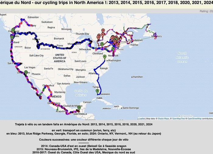
I had fun compiling in one place ALL the routes my partner and I have biked across the planet since 1996: Quebec far and wide, of course, but also Canada, the USA (crossed completely by bike 3 times), Mexico, and all the way to Ushuaia—basically the entire Americas.
In Europe, the Balkans, Turkey; and more recently (2024: Taiwan, Korea, and 4 months in Japan!) You can check out a global map with all the routes by continent, more detailed maps by country, and others that focus on a region, like the Balkans in Eastern Europe. In short, there’s something for everyone!
I’ve included 3 photos here, but the originals (via the link above) let you zoom in infinitely. Plus, many of my routes are represented by lines with a different color for each day of biking. Hope some of you enjoy browsing through all this as much as I enjoyed compiling it. Until the snow comes, skiing... and spring!
https://www.crazyguyonabike.com/doc/TDM_en_Tandem_Trajets_Maps
Hello fellow cycling friends,
I’m heading out very soon for a few weeks in France and elsewhere on my trusty two-wheeled steel steed, with a total of me + luggage = around 120 kg gross weight, and I’ve never really tackled mountain passes before—something I’ll definitely be facing this time...
Currently, I’m running 700c wheels and a Deore XT 10-speed drivetrain (long-cage derailleur) with a 26/36/48 chainring setup and an 11-36 cassette. I’m considering two options (and possible modifications) to get a lower gear ratio (currently 0.72) and spin more easily on steep and mountainous climbs...
1 – Install an 11-42 cassette This would give me a gear ratio of 0.61. Would this be feasible with my current rear derailleur, please?
I have several new chains with 116 links—would these work for this cassette, which would have 6 more teeth on the largest cog, or would I need a longer chain?
2 – Swap the 26-tooth small chainring for a 24-tooth one This would give me a gear ratio of 0.66. Would this be feasible, please?
When switching to a 24T, will the gap be accepted by the 36-tooth middle chainring, and will shifting remain as smooth as it is now? Will this setup (24/36/48 + 11-36 cassette) still work well together, in your opinion?
Which of these two options do you think would be more feasible and preferable?
What drivetrain and gearing do you use on your bikes for loaded touring that sometimes involves climbing mountain passes and other steep ascents?
So many questions... Thanks for your answers and advice! Have a great day,
Spady
I’m heading out very soon for a few weeks in France and elsewhere on my trusty two-wheeled steel steed, with a total of me + luggage = around 120 kg gross weight, and I’ve never really tackled mountain passes before—something I’ll definitely be facing this time...
Currently, I’m running 700c wheels and a Deore XT 10-speed drivetrain (long-cage derailleur) with a 26/36/48 chainring setup and an 11-36 cassette. I’m considering two options (and possible modifications) to get a lower gear ratio (currently 0.72) and spin more easily on steep and mountainous climbs...
1 – Install an 11-42 cassette This would give me a gear ratio of 0.61. Would this be feasible with my current rear derailleur, please?
I have several new chains with 116 links—would these work for this cassette, which would have 6 more teeth on the largest cog, or would I need a longer chain?
2 – Swap the 26-tooth small chainring for a 24-tooth one This would give me a gear ratio of 0.66. Would this be feasible, please?
When switching to a 24T, will the gap be accepted by the 36-tooth middle chainring, and will shifting remain as smooth as it is now? Will this setup (24/36/48 + 11-36 cassette) still work well together, in your opinion?
Which of these two options do you think would be more feasible and preferable?
What drivetrain and gearing do you use on your bikes for loaded touring that sometimes involves climbing mountain passes and other steep ascents?
So many questions... Thanks for your answers and advice! Have a great day,
Spady
Hi everyone,
After a break of a few years, I’m heading back to Madagascar this October. I’d like to travel from Diego to Maroantsetra via Cap Masoala as much as possible by bike—it’s my favorite way to travel. My questions: for the return trip to Diego once I’m in Maroantsetra, is there a possibility to take a flight, since the road option only starts much further south than Tamatave? Or where can I rent or buy a decent bike between Diego and Cap Masoala? For this bike trip, I’m open to any info—I love traveling rough. Someone might even want to join me on this adventure.
After that, I’d also like info on the northeast part (Mozambique Channel side) of Diego, which I’d like to explore by bike as well.
Thanks, and feel free to share any tips—just skip the paternalistic safety advice. Laurent
After that, I’d also like info on the northeast part (Mozambique Channel side) of Diego, which I’d like to explore by bike as well.
Thanks, and feel free to share any tips—just skip the paternalistic safety advice. Laurent
Great news that the forum is back—we’ve been waiting for this for ages! Now we can chat again with the die-hards like Claudio, Luc Bertand, and everyone else...
Voyager à vélo
Hi everyone,
I’m planning to bike around the Mediterranean. I’m supposed to go through North Africa, but it seems a bit complicated. Visas and travel in Algeria and Egypt only work if you book a hotel (no nights spent outside?). Libya is generally very unclear, and it seems you can only travel there with a local guide (which doesn’t exist for bike trips). If necessary, I’d skip Libya, but neither a bus ride nor a boat detour seems possible to enter Egypt.
Does anyone have tips on how to get around these issues and secure a visa?
Thanks for any advice!
I’m planning to bike around the Mediterranean. I’m supposed to go through North Africa, but it seems a bit complicated. Visas and travel in Algeria and Egypt only work if you book a hotel (no nights spent outside?). Libya is generally very unclear, and it seems you can only travel there with a local guide (which doesn’t exist for bike trips). If necessary, I’d skip Libya, but neither a bus ride nor a boat detour seems possible to enter Egypt.
Does anyone have tips on how to get around these issues and secure a visa?
Thanks for any advice!
Hello there, pedal-powered Young Boys!
Claudio (still from Faverges)
dreaming about a cycling getaway in Italy from Faverges (train all the way to Turin)
from Turin down to Venice along the Po River and back via the Padana (Alta Italia da attraversare – Northern Italy to cross)
The tricky part is getting from Chioggia to Venice.
I read it’s possible by hopping on a boat from island to island,
but it sounds a bit stressful.
Has anyone already tackled this route?
Thanks, and cheers to all! http://cbandiera.free.fr/parcours/Padania/
Claudio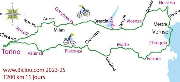
Thanks, and cheers to all! http://cbandiera.free.fr/parcours/Padania/
Claudio
Hi there,
Just a few words about the loop I did by bike in Yunnan.
Entry and exit
I entered China through the Sino-Vietnamese border crossing at Lào Cai / Hekou under the 30-day visa exemption currently available to French nationals and others.
The process was simple and quick. A Chinese police officer even helped me complete my electronic pre-registration at a computer kiosk. I wasn’t aware this formality was required—it’s similar to Thailand’s TM6.
No issues with the bike.
I left the country via the Sino-Laotian border crossing at Mohan / Boten.
The atmosphere was a bit chaotic there, but again, no problems with the bike.
The timing
I visited Yunnan in February 2026.
Weather-wise, at higher altitudes (between 1,500 and 2,000 meters), it was around ten degrees at night and in the mornings, and around twenty degrees at the hottest part of the day.
I had two days of rain, so I took the bus to keep moving. Otherwise, clear blue skies.
Culturally, Chinese New Year fell on February 17th (and the 15 days following), right in the middle of my trip. Because of this, my take on the traffic might be off.
Accommodation and food I always found a hotel to stay in for prices ranging from 8 to 15 €. Except in Kunming (the capital), where many hotels were fully booked (Chinese New Year). I ended up at a 100 € hotel with great value for money.
A bowl of noodles costs about 1.5 € on average.
Onboard electronics Since my smartphone doesn’t support eSIMs, I subscribed to a China plan with my carrier. Otherwise, for much cheaper, Alipay offers eSIMs for foreigners that allow access to services usually blocked for Chinese users (WhatsApp, Facebook, etc.).
An internet connection is essential for paying with Alipay or WeChat, as this payment method is widespread.
I only managed to use Alipay.
Either way, always carry cash because sometimes there’s no signal, or the merchant only accepts WeChat.
Also, it’s best to bring a power adapter when you arrive rather than struggling to find one.
Traffic and roads The Chinese aren’t reckless drivers. They follow traffic rules and watch out for cyclists. This is slightly less true in Xishuangbanna (the region bordering Myanmar and Laos).
In urban areas, there are almost always wide bike lanes, separated from other roads, where bikes, electric mini-scooters, and scooters share the space pretty harmoniously.
The roads are in great condition, and traffic is generally manageable—even light—except for one stretch (Eshan -> Yangwu).
Most traffic is absorbed by expressways, China’s equivalent of highways: toll roads that are off-limits to slow vehicles.
You’re never far from these expressways; sometimes you even ride alongside them, which can be noisy at times.
The climbs are usually reasonable, around 5% to 6%. From what I remember, the steepest section was between Menglun and Mengla, with gradients of 8% to 10%, sometimes more.
Riding at these altitudes—though modest—took a bit of getting used to.
The route I didn’t plan anything in advance. My only goal was to reach Kunming. I don’t know why, but just hearing the name of that city, like Yunnan, always felt dreamy to me.
Here’s the breakdown: Hekou -> Man Hao (94 km); Man Hao -> Yuanyang (64 km); Yuanyang -> Jianshui (bus); Jianshui -> Tong Hai (78 km); Tong Hai -> Chenjiang (85 km); Chenjiang -> Kunming (60 km); Kunming -> Kunyang (60 km); Kunyang -> Eshan (67 km); Eshan -> Yangwu (58 km); Yangwu -> Yuanjiang (59 km); Yuanjiang -> Pu'er (bus); Pu'er -> Dadugang (75 km); Dadugang -> Jinghong (80 km); Jinghong -> Menglun (67 km); Menglun -> Mengyuancun (51 km); Mengyuancun -> Mengla (43 km); Mengla -> Boten (67 km).
Otherwise, I’m currently in Thailand and just hoping my return flight with Qatar won’t get canceled.
Oh well... 😉
Just a few words about the loop I did by bike in Yunnan.
Entry and exit
I entered China through the Sino-Vietnamese border crossing at Lào Cai / Hekou under the 30-day visa exemption currently available to French nationals and others.
The process was simple and quick. A Chinese police officer even helped me complete my electronic pre-registration at a computer kiosk. I wasn’t aware this formality was required—it’s similar to Thailand’s TM6.
No issues with the bike.
I left the country via the Sino-Laotian border crossing at Mohan / Boten.
The atmosphere was a bit chaotic there, but again, no problems with the bike.
The timing
I visited Yunnan in February 2026.
Weather-wise, at higher altitudes (between 1,500 and 2,000 meters), it was around ten degrees at night and in the mornings, and around twenty degrees at the hottest part of the day.
I had two days of rain, so I took the bus to keep moving. Otherwise, clear blue skies.
Culturally, Chinese New Year fell on February 17th (and the 15 days following), right in the middle of my trip. Because of this, my take on the traffic might be off.
Accommodation and food I always found a hotel to stay in for prices ranging from 8 to 15 €. Except in Kunming (the capital), where many hotels were fully booked (Chinese New Year). I ended up at a 100 € hotel with great value for money.
A bowl of noodles costs about 1.5 € on average.
Onboard electronics Since my smartphone doesn’t support eSIMs, I subscribed to a China plan with my carrier. Otherwise, for much cheaper, Alipay offers eSIMs for foreigners that allow access to services usually blocked for Chinese users (WhatsApp, Facebook, etc.).
An internet connection is essential for paying with Alipay or WeChat, as this payment method is widespread.
I only managed to use Alipay.
Either way, always carry cash because sometimes there’s no signal, or the merchant only accepts WeChat.
Also, it’s best to bring a power adapter when you arrive rather than struggling to find one.
Traffic and roads The Chinese aren’t reckless drivers. They follow traffic rules and watch out for cyclists. This is slightly less true in Xishuangbanna (the region bordering Myanmar and Laos).
In urban areas, there are almost always wide bike lanes, separated from other roads, where bikes, electric mini-scooters, and scooters share the space pretty harmoniously.
The roads are in great condition, and traffic is generally manageable—even light—except for one stretch (Eshan -> Yangwu).
Most traffic is absorbed by expressways, China’s equivalent of highways: toll roads that are off-limits to slow vehicles.
You’re never far from these expressways; sometimes you even ride alongside them, which can be noisy at times.
The climbs are usually reasonable, around 5% to 6%. From what I remember, the steepest section was between Menglun and Mengla, with gradients of 8% to 10%, sometimes more.
Riding at these altitudes—though modest—took a bit of getting used to.
The route I didn’t plan anything in advance. My only goal was to reach Kunming. I don’t know why, but just hearing the name of that city, like Yunnan, always felt dreamy to me.
Here’s the breakdown: Hekou -> Man Hao (94 km); Man Hao -> Yuanyang (64 km); Yuanyang -> Jianshui (bus); Jianshui -> Tong Hai (78 km); Tong Hai -> Chenjiang (85 km); Chenjiang -> Kunming (60 km); Kunming -> Kunyang (60 km); Kunyang -> Eshan (67 km); Eshan -> Yangwu (58 km); Yangwu -> Yuanjiang (59 km); Yuanjiang -> Pu'er (bus); Pu'er -> Dadugang (75 km); Dadugang -> Jinghong (80 km); Jinghong -> Menglun (67 km); Menglun -> Mengyuancun (51 km); Mengyuancun -> Mengla (43 km); Mengla -> Boten (67 km).
Otherwise, I’m currently in Thailand and just hoping my return flight with Qatar won’t get canceled.
Oh well... 😉
I’m planning a journey of about 2500 km starting from San Pedro de Atacama (duration: max. 2 months). This trip, almost entirely on remote trails, promises to be an extraordinary adventure.
Highlights of the trip - Crossing the Florido Desert (during the blooming season: October 15–30) - Hiking ascents of legendary volcanoes: - Ojos del Salado (6879 m) - Llullaillaco (6739 m) - Uturuncu (6008 m, with 5820 m reachable by mountain bike!) - A 300 km stage through the heart of the desert, with no resupply or habitation: the ultimate experience of solitude and self-transcendence.
Practical details - Daily distance: max. 100 km and 1000 m elevation gain per day - Average altitude: 4000 m (between 3500 and 5000 m) - Temperatures: ~15 °C during the day, down to -25 °C at night (in a tent) - Accommodation: ~50% in villages (with locals or small hostels), ~50% camping
Estimated budget - 1400 € for the flight ticket (including bike supplement) - 1000 € for on-the-ground expenses
Required equipment - Fatbike (essential for deep sand) - -25 °C comfort sleeping bag - Single-wheel trailer (indispensable for these tough terrains)
My experience In 2022, I completed a similar 1200 km trip north of San Pedro de Atacama: - Full crossing of the Salar de Uyuni (170 km) - Ascents of the Ollague (5868 m) and Aucanquilcha (6176 m) volcanoes - Two 200 km stages with no resupply or human presence Videos available for a glimpse of the adventure: - Atacama Crossing 2022 - Part 1 - Atacama Crossing 2022 - Part 2
Next steps If this adventure interests you, I suggest: 1. A first phone call to get to know each other 2. A meet-up over a drink or a test ride in the Bardenas Reales (similar terrain, and I live 100 km away)
Don’t hesitate to contact me for more info or to discuss the details!
Highlights of the trip - Crossing the Florido Desert (during the blooming season: October 15–30) - Hiking ascents of legendary volcanoes: - Ojos del Salado (6879 m) - Llullaillaco (6739 m) - Uturuncu (6008 m, with 5820 m reachable by mountain bike!) - A 300 km stage through the heart of the desert, with no resupply or habitation: the ultimate experience of solitude and self-transcendence.
Practical details - Daily distance: max. 100 km and 1000 m elevation gain per day - Average altitude: 4000 m (between 3500 and 5000 m) - Temperatures: ~15 °C during the day, down to -25 °C at night (in a tent) - Accommodation: ~50% in villages (with locals or small hostels), ~50% camping
Estimated budget - 1400 € for the flight ticket (including bike supplement) - 1000 € for on-the-ground expenses
Required equipment - Fatbike (essential for deep sand) - -25 °C comfort sleeping bag - Single-wheel trailer (indispensable for these tough terrains)
My experience In 2022, I completed a similar 1200 km trip north of San Pedro de Atacama: - Full crossing of the Salar de Uyuni (170 km) - Ascents of the Ollague (5868 m) and Aucanquilcha (6176 m) volcanoes - Two 200 km stages with no resupply or human presence Videos available for a glimpse of the adventure: - Atacama Crossing 2022 - Part 1 - Atacama Crossing 2022 - Part 2
Next steps If this adventure interests you, I suggest: 1. A first phone call to get to know each other 2. A meet-up over a drink or a test ride in the Bardenas Reales (similar terrain, and I live 100 km away)
Don’t hesitate to contact me for more info or to discuss the details!
Hi there,
I got a handlebar bag for my bike with a KlickFix system and a Galaxy Tab A tablet. I can fit the tablet into the waterproof transparent pouch on the bag—it’s absolutely awesome, I’ve got my dashboard right on the handlebar! I’d like to use Locus Map for geolocation and create a route from Nantes to Saint-Fiacre-sur-Maine. On my PC, with Locus Map, I see the interface on the left to create a planned route (like in the red-framed screenshot below). But on my tablet (using the app), I can’t find the interface to create a planned route from point A to B like I can on the PC. I need help figuring out how to create a route from A to B on my tablet with Locus Map—I know how to find and download a GPX file, but for Nantes to Saint-Fiacre-sur-Maine, there’s no GPX file available online. Also, does anyone know how to remove the ads on Locus Map?
Thanks in advance—David
I got a handlebar bag for my bike with a KlickFix system and a Galaxy Tab A tablet. I can fit the tablet into the waterproof transparent pouch on the bag—it’s absolutely awesome, I’ve got my dashboard right on the handlebar! I’d like to use Locus Map for geolocation and create a route from Nantes to Saint-Fiacre-sur-Maine. On my PC, with Locus Map, I see the interface on the left to create a planned route (like in the red-framed screenshot below). But on my tablet (using the app), I can’t find the interface to create a planned route from point A to B like I can on the PC. I need help figuring out how to create a route from A to B on my tablet with Locus Map—I know how to find and download a GPX file, but for Nantes to Saint-Fiacre-sur-Maine, there’s no GPX file available online. Also, does anyone know how to remove the ads on Locus Map?
Thanks in advance—David
Hi everyone,
I’m trying to get familiar with a route on Locus Map. The issue is that Locus Map’s geolocation isn’t accurate on my PC.
In the link, the red cross shows where I live, and the blue cross shows where Locus Map geolocated me. There’s a difference of about 1.5 km.
My question is: will there always be this kind of error every time I ask Locus Map to geolocate me?
I’m trying to get familiar with a route on Locus Map. The issue is that Locus Map’s geolocation isn’t accurate on my PC.
In the link, the red cross shows where I live, and the blue cross shows where Locus Map geolocated me. There’s a difference of about 1.5 km.
My question is: will there always be this kind of error every time I ask Locus Map to geolocate me?
We’re planning to cycle along the Baltic coast this summer, from Flensburg all the way to the Polish border—and maybe even a little farther along the Polish coast.
By e-bike and staying in hotels (we’re not exactly spring chickens).
Any tips? Challenges, places to stay, signage?
Other thoughts?
hi fellow cyclists!
Outside, the weather isn’t great for bike escapes! But that doesn’t stop us from planning ahead. Starting to look at a map or other resources is when the journey begins! So, what are your plans? For us, there’s a trip in the drawer ready for a few months now—heading south (Montpellier) from the Allier department! Another idea has been taking shape: Corrèze, Périgord!!! Looking forward to reading your replies, have a great day! !
Outside, the weather isn’t great for bike escapes! But that doesn’t stop us from planning ahead. Starting to look at a map or other resources is when the journey begins! So, what are your plans? For us, there’s a trip in the drawer ready for a few months now—heading south (Montpellier) from the Allier department! Another idea has been taking shape: Corrèze, Périgord!!! Looking forward to reading your replies, have a great day! !
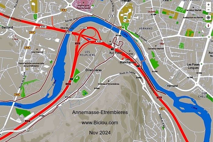
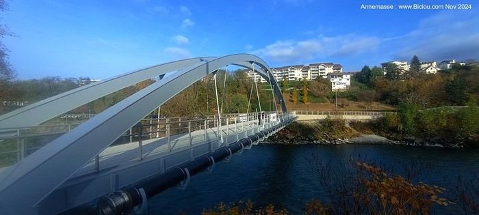
claudio didn’t get its purpose: no secure bike access and it leads to a sketchy path through a grim commercial zone that’s really tough to ride on at the exit. Anyone have an explanation?
http://cbandiera.free.fr/vlsrt/bld-z.php?N=6359
http://cbandiera.free.fr/vlsrt/bld-z.php?N=6359
Hi fellow travelers,
I’m an old-school cycle tourist, traveling by bike... and I’ll be heading to England, Scotland, and Ireland in September. I was wondering if cash is still used in supermarkets, grocery stores, and generally—do people still use cash in the UK?
Thanks for your replies, happy travels!
I’m an old-school cycle tourist, traveling by bike... and I’ll be heading to England, Scotland, and Ireland in September. I was wondering if cash is still used in supermarkets, grocery stores, and generally—do people still use cash in the UK?
Thanks for your replies, happy travels!
Hello,
I’m planning to cycle from Paris to Prague in three weeks. It’s the worst time of year temperature-wise, especially since I’m pretty sensitive to the cold. But I don’t have a choice about either the timing or the destination (it’s a break between two jobs that just happens to fall during this period, and I’m heading to Prague to meet friends for a specific event in mid-February).
So it’s going to be *very* cold. And while I’ve done a few relaxed one- to two-week bike trips before, I’ve never cycled in winter. That’s why I’d love your advice on two things! :)
1- Accommodation along the route On my previous trips, the weather was more forgiving, so I always brought my tent and didn’t have to worry about accommodation logistics. But this time, it’s a whole different story—I won’t be able to sleep outside (too cold + it gets dark too early). So I need to plan all my lodging in advance.
I’ve looked at a few existing threads about cycling from Paris to Prague, but they all focus on campsites/tents since the timing allowed for outdoor sleeping. Does anyone know: 1- If those campsites, which seem to be fairly evenly spaced along the route, have winter facilities (I assume most close in winter, but you never know)? This is especially important for the German and Czech sections (I’ll be fine in France). 2- How easy it is to find affordable youth hostels everywhere, and if so, whether I should book them in advance?
2- Winter cycling gear Since I’ve never cycled in winter before, I don’t have the right gear. I’m particularly concerned about gloves and shoes, since my extremities will take a beating. What shoes would you recommend for temperatures around 0°C? I don’t plan to cycle in winter again after this, and all my other trips have been in regular running shoes, which worked just fine for me. So I’d prefer not to spend a fortune on super technical gear that I’ll only use once. But I also don’t want to skimp on cold protection—being freezing could ruin the whole trip. So if the only solution is "super technical" shoes, I’ll go for it.
> What shoes do you wear or recommend for simple bike trips that keep your feet warm and dry? > Does the overshoe option (over a pair of regular sneakers, for example) seem like a good solution? (I just discovered overshoes—I have no idea how effective they are.) If so, are Decathlon’s overshoes good enough, or should I go to a specialty bike shop?
Thanks so much!
(Oops, sorry for the novel...)
I’m planning to cycle from Paris to Prague in three weeks. It’s the worst time of year temperature-wise, especially since I’m pretty sensitive to the cold. But I don’t have a choice about either the timing or the destination (it’s a break between two jobs that just happens to fall during this period, and I’m heading to Prague to meet friends for a specific event in mid-February).
So it’s going to be *very* cold. And while I’ve done a few relaxed one- to two-week bike trips before, I’ve never cycled in winter. That’s why I’d love your advice on two things! :)
1- Accommodation along the route On my previous trips, the weather was more forgiving, so I always brought my tent and didn’t have to worry about accommodation logistics. But this time, it’s a whole different story—I won’t be able to sleep outside (too cold + it gets dark too early). So I need to plan all my lodging in advance.
I’ve looked at a few existing threads about cycling from Paris to Prague, but they all focus on campsites/tents since the timing allowed for outdoor sleeping. Does anyone know: 1- If those campsites, which seem to be fairly evenly spaced along the route, have winter facilities (I assume most close in winter, but you never know)? This is especially important for the German and Czech sections (I’ll be fine in France). 2- How easy it is to find affordable youth hostels everywhere, and if so, whether I should book them in advance?
2- Winter cycling gear Since I’ve never cycled in winter before, I don’t have the right gear. I’m particularly concerned about gloves and shoes, since my extremities will take a beating. What shoes would you recommend for temperatures around 0°C? I don’t plan to cycle in winter again after this, and all my other trips have been in regular running shoes, which worked just fine for me. So I’d prefer not to spend a fortune on super technical gear that I’ll only use once. But I also don’t want to skimp on cold protection—being freezing could ruin the whole trip. So if the only solution is "super technical" shoes, I’ll go for it.
> What shoes do you wear or recommend for simple bike trips that keep your feet warm and dry? > Does the overshoe option (over a pair of regular sneakers, for example) seem like a good solution? (I just discovered overshoes—I have no idea how effective they are.) If so, are Decathlon’s overshoes good enough, or should I go to a specialty bike shop?
Thanks so much!
(Oops, sorry for the novel...)
hi there
After covering thousands of kilometers over the years with front and rear panniers, I’m now facing a problem: broken spokes on the rear wheel.
Once, twice—imagine the hassle of fixing it when you're in the middle of nowhere in the Cévennes!
So, drastic times call for drastic measures! I switched to a reinforced wheel and, following my bike mechanic’s advice, fitted a tire that’s a "tad" wider than the front one.
We set off on our summer adventure feeling confident, and guess what—"BAM"—a broken spoke after just 200 km. Seriously?! Not even that heavily loaded—just around 30 kg, plus my 80 kg. Even with the sturdier wheel, I still ended up with a broken spoke after 300 km! Back to the bike mechanic, and the only explanation: "It’s your pedaling style..." Not convinced at all! So here’s the idea: a Bob trailer! I’m done with this sword of Damocles hanging over my head—it’s a real buzzkill. Has anyone here tried a Bob trailer? Could you share your experiences—pros, cons, etc.? Thanks!!!
We set off on our summer adventure feeling confident, and guess what—"BAM"—a broken spoke after just 200 km. Seriously?! Not even that heavily loaded—just around 30 kg, plus my 80 kg. Even with the sturdier wheel, I still ended up with a broken spoke after 300 km! Back to the bike mechanic, and the only explanation: "It’s your pedaling style..." Not convinced at all! So here’s the idea: a Bob trailer! I’m done with this sword of Damocles hanging over my head—it’s a real buzzkill. Has anyone here tried a Bob trailer? Could you share your experiences—pros, cons, etc.? Thanks!!!
Hi everyone,
We’re planning to spend 5 months cycling as a family in Central Asia. To align with the weather, we’re thinking of arriving in Uzbekistan in April, heading toward the Ferghana Valley in late April/early May, and wrapping up with a long stretch in Kyrgyzstan from mid-May to early August.
I haven’t really dug into the third part (Kyrgyzstan) yet, but from what I’ve seen on the forum and online, cycling across Uzbekistan doesn’t seem all that appealing: long, straight desert stretches with lots of trucks.
Has anyone come across any "hidden gem" routes they’d be willing to share? I’ve already noted that it’s best to avoid riding toward Tashkent. I’m looking for routes between Bukhara and Samarkand, and any nearby areas that are nice for cycling.
I’d love to fly into Dushanbe to reach Samarkand, but we all agree that it’s not a good fit for the season (early April) if we’re cycling, right?
Thanks for your feedback! Ludo
I haven’t really dug into the third part (Kyrgyzstan) yet, but from what I’ve seen on the forum and online, cycling across Uzbekistan doesn’t seem all that appealing: long, straight desert stretches with lots of trucks.
Has anyone come across any "hidden gem" routes they’d be willing to share? I’ve already noted that it’s best to avoid riding toward Tashkent. I’m looking for routes between Bukhara and Samarkand, and any nearby areas that are nice for cycling.
I’d love to fly into Dushanbe to reach Samarkand, but we all agree that it’s not a good fit for the season (early April) if we’re cycling, right?
Thanks for your feedback! Ludo
Hello, I spent a month cycling in Thailand earlier this year with a touring bike equipped with two rear panniers. I loved being able to ride and stop at a hotel every night, and eat just about anywhere. I tried India two months ago but gave up because of the road conditions and chaotic traffic.
I’m looking for countries where I can cycle "without autonomy"—so no tent, no stove, just the bare minimum. Ideally, I’d like to stop at hotels or similar accommodations regularly, without having to cover 200 km a day!
I’d love to hear from your experiences—what countries make it easy to travel this way? Thanks!
I’m looking for countries where I can cycle "without autonomy"—so no tent, no stove, just the bare minimum. Ideally, I’d like to stop at hotels or similar accommodations regularly, without having to cover 200 km a day!
I’d love to hear from your experiences—what countries make it easy to travel this way? Thanks!
Hi there,
We’re leaving from Montreal and planning to bike the Petit Train du Nord route.
Any ideas for loops so we don’t have to return the same way?
We’re thinking of a one-week trip.
Thanks in advance for your tips!
Rachel
Hey fellow cyclists,
Cyclists on trails, paths, or greenways—why do so few (if any) of you use your bells to warn walkers, runners, and other pedestrians when they’re moving in the same direction as you?
I exercise every day (brisk walking) among you in France and abroad, and it’s something I’ve noticed—often with a few scares (and I’m guessing some accidents between cyclists or with pedestrians).
Personally, I always stick to the rules, walking on the left (facing traffic) so I can see you coming, but not everyone does that—neither pedestrians nor cyclists, and let’s be honest, it’s a bit of a free-for-all. 🤪
Your bikes make little to no noise, so why take risks and put others at risk too?
A quick, light *ding-ding* would be enough to warn people—what do you think? 😅
Hello, I'm looking for a small town where we can eat and stay near the canals of Brittany to do short bike rides of about 50 km round trip. Ideally, it would be a town at a junction of several canals, but I'm not sure if that exists. Otherwise, a town like Redon with the Nantes-Brest canal and, on the other side, the Vilaine River. But I don’t know if there are paths that can be used along these canals.
Thanks for replying if you have any ideas.
Cheers, Néo.
Thanks for replying if you have any ideas.
Cheers, Néo.
I'm developing a free and open-source web app for planning walking and cycling trips (and even car trips). You can create a route by clicking directly on the map to add waypoints, and it can consist of multiple stages. The app provides tools to edit the stages and the overall route, and to display useful information (distances, altitudes, and elevation changes). A relief profile can be shown as a graph for a specific stage or the entire route.
Once the route is ready, it can be exported as a GPX file, which can then be used with a GPS or a mobile navigation app.
The app is built in JavaScript and runs entirely in the web browser. It uses the Leaflet library and several OpenStreetMap-based services. Initially developed for my personal needs (I enjoy hiking and cycle touring), I’d be happy to share it with anyone who might find it useful. It’s free to use, doesn’t require an account, and the source code is available.
Source code: https://github.com/patricklmarie/GPX-Route-Planner Online demo: https://patricklmarie.github.io/GPX-Route-Planner/
Once the route is ready, it can be exported as a GPX file, which can then be used with a GPS or a mobile navigation app.
The app is built in JavaScript and runs entirely in the web browser. It uses the Leaflet library and several OpenStreetMap-based services. Initially developed for my personal needs (I enjoy hiking and cycle touring), I’d be happy to share it with anyone who might find it useful. It’s free to use, doesn’t require an account, and the source code is available.
Source code: https://github.com/patricklmarie/GPX-Route-Planner Online demo: https://patricklmarie.github.io/GPX-Route-Planner/
Hi everyone,
We’re organizing a week-long bike trip for a group of scouts.
I’ve already mapped out a route using Géovélo (travel option).
The teens will take the train to Nemours (or a bit beyond) and then follow the Loire à Vélo route for a good stretch (until Nevers, which they’ll bypass to the west).
After Nevers, things get a bit trickier.
I also wanted to avoid Moulins, so I planned for them to follow the Allier’s west bank and cross near Châtel-de-Neuvre.
I’m having some doubts about the route and really want to steer clear of busy main roads as much as possible.
I’d love to hear your thoughts on the route I’ve chosen, plus any tips you might have.
I saw there’s the V70 veloroute, but I decided against it after hearing it has some *very* road-heavy sections.
Hi there,
No recent discussion here on the topic (2025).
Anyone else interested?