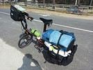
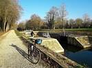
aprés mon petit WE cyclocamping Montpellier/La Bouilladisse par la Camargue et la digue à la mer, j'envisage vers le 15/8 de faire Nice / La Bouilladisse par la Bonette (Nice-StEtienne de Tinée/St Etienne de Tinée-Tallard/Tallard-La Bouilladisse)
ma question est la suivante : quelqu'un à t'il monté la Bonette avec les sacoches ? et en gros combien faut il de temps? un collégue a mis 2 heures en vélo route 3 heures est ce réaliste?
je ne suis pas une fusée mais déjà plus de 1600 kms vélo depuis le début de l'année et + de 450 kms de course à pied sans compter les randos notamment en montagne en ce moment
Bonjour Serge tout se monte avec des sacoches il suffit de prendre le temps petit développement et à 5km/h on monte tranquille en regardant le panorama prendre de l’ampleur au fur et à mesure de la montée. Mais c'est vrai que dans les grands cols des Alpes on ne voit pas tellement de "sacochards".
Je pars toujours sans entraînement donc avec l'entraînement annoncé 3h cela me semble raisonnable, mais aussi cela dépend du poids des sacoches 10 ou 20 kg?, Saint-Etienne de Tinée 1140 m et le col 2700 et si on fait le tour de la route au-dessus passage à 2800
Dans une traversée Thonon Nice j’y étais passé tranquille 4h, ci-dessous le CR de cette journée :
Huitième jour : Jausiers Saint Sauveur de Tinée 81 km
Ce petit hôtel où nous sommes descendus, je le connaissais pour y avoir dormi lors d’une virée d’escalade dans la région. La patronne est très agréable et nous parle de la vie locale. En particulier elle nous révèle, et cela ne nous surprend pas, que les motards de passage font significativement monter le chiffre d’affaire.
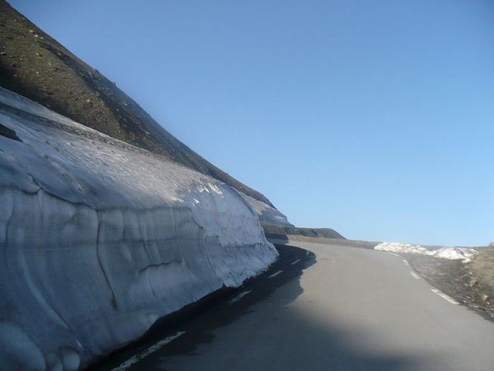
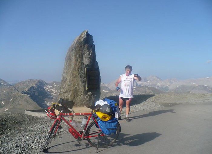
Après un petit déjeuner copieux nous nous préparons pour la grosse étape du col de Restefond, 24 kilomètres. Ils se déroulent tout le long d’un gigantesque pan de montagne pelée. A notre vitesse lente nous allons mettre pas loin de quatre heures pour arriver à ce passage entre Ubaye et Tinée. Le ciel est clément, la forme est bonne. Le panorama qui s’élargit à chaque tour de pédalier, nous permet de pleinement profiter de ce moment. Ce qui pourrait être un calvaire se transforme en pur bonheur. La fin du parcours est particulièrement austère, le sol constitué d’une caillasse grise, couleur ardoise, donne au paysage une note de dureté et de froideur. Un vent modéré souffle, ce qui renforce cette sensation de nature sauvage. Au col, même pas un panneau. Nous n’irons pas jusqu’au point 2802 mètres, effectuer la boucle de 1600 mètres autour du sommet, bien qu’il s’agisse de la route la plus haute d’Europe.
Devant nous s’ouvre la vallée de la Tinée. Nous sentons que le terme de notre voyage se rapproche. Cette vallée qui débute, si nous la suivions, elle nous conduirait directement à Nice en une centaine de kilomètres. Mais notre itinéraire comporte encore deux cols. Nous allons suivre la vallée de la Tinée jusqu’à Saint Sauveur et de là nous rejoindrons la Vésubie.
Après une magnifique descente nous nous arrêtons à Saint-Etienne de Tinée, pour déjeuner. Il nous reste une trentaine de kilomètres pour rejoindre Saint Sauveur. La route descend le long de cette profonde vallée. Au sortir de la ville nous rencontrons un couple de cyclistes italiens à la recherche d’un hébergement pour la nuit. La femme semble assez énervée du fait de ne rien trouver. En effet, ils ont poussé jusqu’à Isola, mais en intersaison, ils sont arrivés dans une ville morte. J’adore entendre cette italienne parler sur son ton haut perché, appuyant sur l’accent tonique. Je ne puis m’empêcher de lui dire « l’italiano e la piu bella lingua d’el mondo ». Je ne suis pas sûr que ce soit de l’italien bien correct, mais elle comprend.
Suite à cet intermède rigolo, nous reprenons notre route, qui parfois suit une piste cyclable très agréable. Enfin nous arrivons et le gîte municipal est ouvert. Nous nous installons et ce soir nous serons sept dans ce dortoir. Un couple d’Allemands, un Suisse et deux ouvriers travaillant sur un chantier de percement de tunnel près du village qui nous domine, Roure. L’un des occupants a manifestement des problèmes d’odeur de pieds et nous en fera largement et généreusement profiter! Le village est plein de chats pas farouches qui se laissent caresser, ce qui me ravit. Le couple d’Allemands accepte une invitation au restaurant du village et nous passerons un très agréable moment, ce qui entre autre me donnera l’occasion d’utiliser leur langue, que j’aime beaucoup.
Ci-dessous le lien vers la balade en entier :
voyageforum.com/...ost=4570862;#4570862
Lors d'un petit tour des Alpes y'a deux ans en partant de Grenoble, j'étais passé par le Lautaret, Izoard, Agnel, Sampeyre, Vallonetto. J'avais campé dans la montée de la Lombarde côté Italie que j'avais déjà un peu entamée (à peine).
je suis monté au sanctuaire Santa Anna di Vinadio (clin d'oeil à Nibali), passé la Lombarde et ai monté la Bonnette dans la journée. J'ai campé dans la descente.
J'avais un vélo lourd (mon vélo de voyage fait 16 kg) et j'étais bien chargé avec la tente, le réchaud, tout le barda. 4 sacoches plus celle de guidon.
J'ai du quitté Isola vers 15h-16h, je sais plus trop. Et étais arrivé vers 21h à la cime. C'était chouette, en défiant le coucher de soleil au fur et à mesure que je montais.
En août, tard dans l'aprèm, y'avait personne.
je voyage léger je ne pars que 3 jours 2 nuits en camping, c'est plutôt 10 kgs, l'altitude 2700 m sera suffisante, en cyclocamping je me léve à 5h30 et décolle vers 7h ça devrait aller, par Saint Etienne , c'est 26 kms je crois
Bonne journée à toi, il doit faire chaud à Lyon ou dans les Vosges, j'adore la balade vers l'anneau bleu
Sacré tour bravo, mon vélo est lourd et est tout a fait simple mais me convient trés bien (vieux VTT DECATHLON 340 version femme grande taille auquel j'ai mis un porte bagage et des pneus Vittoria) mais je voyage assez léger, merci pour les infos j'ai déjà fait cette route en voiture mais
pas en vélo, dimanche j'ai monté le col de Larche avec un Italien trés sympa qui était parti de chez lui à coté de Cunéo pour faire une boucle de 220 230 kms par la Bonette il m'a dit que ça allait faire ça 9 iéme bonette
Bon trip à toi. J'y retournerais bien un jour, peut-être dans l'autre sens. J'adore tellement ces paysages lunaires et dramatiques.
Luc, la cime de la Bonnette n'est pas la route la plus haute d'Europe. À ma connaissance, c'est la route del Pico del Veleta en Sierra Nevada (3360m). Quoi que je ne suis pas au fait des routes dans le Caucase européen, y'a peut-être des routes encore plus hautes.
bravo
la Bonette claudio didit deux fois dont en 2008 ! apparemment en un peu moins de 4 heures pour les 23 km
cbandiera.free.fr/...rsee-alpes/index.php
et avé les sacoches
c'est long, tres long mais la pente bien que difficile n'est pas insurmontable
c'est du 6-7 % sauf le dernier km à 9 %
attention cependant aux orages, car c'est le désert la haut
j'étais alors jeune beau et affuté
cbandiera.free.fr/...rsee-alpes/F/74.html
tu peux estimer le temps d e montée en connaissant ta vitesse ascensionnelle à vélo
disons 400 m / h c'est pas mal avé les sacoches moyennement lourdes
a Les pokes pour le Glaude (bien sur en 2019 ces chiffres ont bien changé ..)
Vitesse ascensionnelle de 450 m par heure en moyenne (8 m /mn, ou 1.2 m/sec) pour 83 kilogrammes du phacochère + ses habits et 28 kilogrammes pour Fanny. puissance estimée de 150 watts (les pros du TDF sont à 400 watts et 1400 m/heure)
Quatrième étape : La colonie dort profondément, il est à peine 4 h 30 mn lorsque je descends de ma chambrette, ou je passa une nuit agitée, mais seul : petit déjeuner préparé par les jeunes, tout est parfait, je suis paré pour une longue ascension vers la plus haute route d"europe.J'entends au loin un clocher sonner les cinq coups, lorsque "clac", j'engage mon pied dans la pédale, la pédalée est lourde et hasardeuse sur les débuts de ce col de la Bonette , car la pente est rude.
Mais la route est déserte et tranquille, le jour qui pointe progressivement à quelques chose de magique et divin.
C'est donc tranquillement que j'arpente les 10 premiers kilomètres assez difficiles entre roches, genêts, et bruissement des cascades. Peu de véhicules y sévissent, ils seront 15 exactement sur les 23 kilomètres, essentiellement de beaux militaires en manoeuvre dans ce massif : il y en a partout de ces guerriers, tel un film de western, je les aperçois sur les sommets, au détour d'un virage, en patrouille, ils sont omniprésents.
L'altitude me gagne et me serre le coeur, j'ai un peu de mal à respirer, mais l'ambulance du RP 95 qui me double est rassurante, d'autant plus qu'une jeune cheffe de patrouille à la fesse arrogante et l'oeil malicieux me fixe, un ange passe entre nous deux, 1/4 de seconde, et il faut filer.
Le sommet est en vue, , le regard porte au loin : le paysage est lunaire, désert et magique, je suis aux anges,
Mais lorsque par un ultime coup de rein je m'apprête à franchir en vainqueur et solitaire les 2802 m, un Cyclo surgit du diable vau vert me double, sacoches et coup de pédale rageur, " ah le salaud ".
C'est un cousin à la perfide albion, pas étonnant, il me faut rassembler tout mon mauvais anglais scolaire pour que nous échangeons quelques clichés..
La belle descente à présent sur une route toute neuve, asphaltée pour le TDF : c'est est écœurant presque, nous sommes bien dans l'empire du fric et du paraître.
La longue descente est magique, j'y croise à 9 h mon premier motard en goguette, et de nombreuses marmottes en folie.bonne route
claudio
Bonjour
J'ai monté la Bonnette côté Jausiers, il y a trois ans avec l'équipement complet du sacochard. C'était l'avant dernière étape d'une diagonale Brest Menton effectuée façon pépère, ce que suis par ailleurs.
Plusieurs conseils: ne compte pas ton temps de toute façon il t'en faudra, ne regarde pas les fusées multicolores qui te doublent, d'ailleurs certaines n'atteindront pas le col, souris poliment au photographe posté quelques kilomètres avant le sommet et surtout si tu montes du même côté que moi, GARDE s'en pour le dernier kilomètre.
Je suis monté aussi de l'autre côté mais c'était en 79.... j'étais jeune mais j'avais trouvé le côté sud plus facile.
Bref, ça se monte et quelque soit le temps que tu y mets ce sera un grand bonheur d'arriver au sommet.
PS La photo de mon alias c'est justement celle prise par le photographe quelques km avant le sommet. Je suis même arrivé à sourire et le dit photographe n'a pas eu à utiliser une vitesse rapide pour que je ne sois pas flou... Bon courage
Patrick
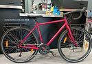
Merci pour toutes ces informations hyper précises, il avait de l'allure ton vélo rouge, je pense que je vais faire comme toi et partir hyper tôt, d'habitude je pars vers 7 h mais je vais bien avancer d'une heure, l'étape précédente n'apparaît pas insurmontable quoique vers la fin ça monte pas mal , je ne ferais pas la même erreur que l'an dernier et prendre cette maudite rive gauche du Var qui est vers la fin effondrée par les crues du Var, j'ai eu du mal pour remonter sur la route,
une fois arrivée aprés montage de la tente douche bain dan le plan d'eau petite collation promenade dans le camping il ne reste plus qu'à aller se coucher, c'est ce que j'apprécie aussi dans le cyclocamping la longueur des nuits même si l'on n'a pas le confort de son lit
Merci pour ton message, quand tu dis coté sud c'est Nice La Bonette ? donc si c'est plus facile de ce coté tant mieux pour moi, j'ai fait ce coté en voiture ça ne m'avait pas impressionné mais je raviserais surement mon jugement quand j'y serais
Bravo pour tes périples, les Stéphanois et les gens du 42 sont des vrais passionnés de vélo, Saint Etienne la capitale du vélo? c'était aussi la capitale du foot, les verts de 1976 quel souvenirs, mais Marseille 1993 sur le toit de l'Europe c'était pas mal non plus
Oui par côté sud je pense au versant partant de Nice. Il ma effectivement semblé plus facile .....mais c'est subjectif et 36 ans se sont écoulées entre les deux montées. C'était d'ailleurs mon premier voyage avec sacoches. Souvenirs, souvenirs..... St Étienne capitale du vélo ? ? Je crois bien malheureusement que le dernier cadreur à cessé ses activités depuis un certain temps!!!!
la cime de la Bonnette n'est pas la route la plus haute d'Europe. À ma connaissance, c'est la route del Pico del Veleta en Sierra Nevada (3360m). Quoi que je ne suis pas au fait des routes dans le Caucase européen,
ça dépend de ce qu'on appelle "route". Si on se limite aux routes asphaltées, il n'y a pas de route plus haute dans le Caucase.
Par contre, contrairement à ce qu'on apprend en géographie dans toutes les écoles de France et d'Italie et probablement d'Europe occidentale, le plus haut sommet d'Europe est incontestablement dans le Caucase (Elbrouz 5642m, il est environ 10 km au nord de la ligne de partage des eaux, et donc géographiquement entièrement en Europe). De même que les plus hautes localités habitées d'Europe sont dans le Caucase et non dans les Alpes.
Voilà, excusez-moi pour ce "hors sujet", mais puisque la question a été évoquée et que j'aime bien le Caucase, je me suis permis cette petite digression...
Une route carrossable étant une route... dans la même dynamique que le fait de déconstruire le mythe occidental du Mont Blanc comme plus haut sommet de l'Europe, il me tient à coeur de rappeler que la plus haute route d'Europe n'est pas en France.
:)
OK, alors si les pistes carrossables, même bien caillouteuses et éventuellement orniérées, sont comptées comme routes, je connais au moins une route plus haute que la Bonette dans le Nord Caucase, mais elle n'est pas plus haute que celle du Pico Veleta. C'est la piste qui monte à l'observatoire de Terskol, sur le flanc sud-est de l'Elbrouz : 3127m.
Bonjour !
pour l avoir fait avec des sacoches( arrières seulement sans tente ) je te dis oui c'est est faisable même plus si tu en as envie fait le ! Le temps qu importe ! prend du plaisir 2h, 4h et alors. ...ns avons fait ça avec ma femme lors de notre traversée des Alpes à vélo Thon on Nice que du bonheur
Bonne ballade à toi !
Merci, oui la durée n'a pas une grande importance, je n'ai pas prévu une longue étape 100 kms
les jours sont encore longs à la mi-Aout, je pense que je devrais partir vers les 6h 6h30 pour profiter de la fraîcheur, c'est bien aussi de ne pas arriver trop tard au camping entre le montage de la tente, la douche, la piscine, le grignotage, le lendemain m'attend une bonne étape de 160 kms pour rentrer chez moi, mais je connais bien le profil ainsi que toutes les fontaines bien utiles,
I’d been watching this ultra-light travel movement or trend for a while.
So I gave it a try—goodbye to the 5 panniers and rear racks.
A 15L saddle bag for clothes and a stove cookset.
Two cages on the fork blades: 2x5L—mattress on one side, tent on the other.
A 5L frame bag for miscellaneous items: battery, camera, small bits and pieces.
And one on the handlebar for the sleeping bag.
I tested it this summer on a crossing from Valence to Perpignan via the Massif Central.
My conclusions:
The obvious advantage is the reduced weight. In total, I had 12 kg on the bike, which makes climbing in the mountains much easier.
Another benefit I hadn’t considered is the significantly lower wind resistance compared to a traditional setup—you really feel it when the wind’s against you.
Of course, it’s not all perfect...
For example, it’s impossible to carry a food stock. You buy just enough before each meal or go to a restaurant!
You also have to accept a more spartan comfort level at stops.
In conclusion, I think for summer trips in regions where resupplying is easy, it’s an interesting option—especially if there’s significant elevation gain.
On the other hand, it doesn’t allow for enough autonomy, so some trips are off the table.
On the bike side, I swapped my Shimano 11/34 cassette for an 11/40. Even though Shimano doesn’t recommend it with a 105 derailleur and a 46/30 double chainring, it works really well.
The only limit is avoiding the 46/40 gear ratio.
Hi,
what are the easiest ways to get back from Nordkapp without pedaling—
train, boat, or plane?
Has anyone already done this?
Thanks for sharing your tips!
Hi, does anyone have recent info on the Shikoku pilgrimage? We’re traveling as a pair by bike, and I plan to camp whenever possible because from what I’ve seen, accommodations are pretty expensive, especially for long trips. I’d love any info or tips—thanks in advance! Aichatou
I’m planning to leave Nice for Toulouse around 10/15 and I’m looking for tips / great deals regarding:
- The route: I was thinking of taking Nice - Grasse - Draguignan - Salernes - Cadarache - Cavaillon - Arles, then the Camargue, Sète, and the Canal du Midi to Toulouse. The idea is to avoid high-traffic roads and too many steep climbs. Are there any spots to avoid or must-see stops? Since it’s been a while since I’ve been on the road, I was thinking that sleeping indoors might be preferable. If you have any budget-friendly accommodation suggestions along part of the route, don’t hesitate!
Thanks in advance, and if you’re in the area around that time, we could ride together... Ciao.
Hi,
I need to arrive in Thessaloniki by bike at the end of September and I plan to head to Istanbul along the coast.
Could anyone help me pick the best route? Safety, difficulty.
Thanks in advance.
Marc
Hi everyone! Thanks for welcoming me to the forum :)
I’m preparing for a long trip heading to Nepal, with stops along the way depending on my mood, work needs, and the season. I cycle a lot, but this will be my first big touring adventure. I’d like to camp regularly to keep costs down, so I’ll be riding on all kinds of surfaces: smooth and rough roads, main highways and rocky paths to find my camping spots, flat terrain and the occasional steep slopes.
For my bike model, I’m prioritizing durability, versatility, and repairability. From that perspective, I prefer a steel frame and fork with rim brakes since I’m used to them. I’ve narrowed my choices down to four models:
- The VSF Fahrradmanufaktur T-700 LTD (1400 €): steel frame, aluminum fork, hydraulic rim brakes, 28" wheels, 40mm tires, 36 spokes (2 mm), lightweight rear rack (max 20 kg), no front rack included, smallest gear ratio of 0.72, weight of 13.9 kg.
- The VSF Fahrradmanufaktur TX-400 (2200 €): steel frame and fork, hydraulic rim brakes, 26" wheels, 50mm tires, 36 spokes (2.34 mm), front and rear racks included (40+18 kg), smallest gear ratio of 0.71, weight of 15.9 kg.
- The Genesis Tour de Fer 30 (2150 €): steel frame and fork, mechanical disc brakes, 28" wheels, 36 spokes, 40mm tires, front and rear racks included (27+10 kg), smallest gear ratio of 0.77, weight of 15.9 kg.
- The Rockrider ADTV 900 from Decathlon (1700 €): aluminum frame and fork, mechanical disc brakes, USB port, 28" wheels, 47mm tires, 28 spokes, front and rear racks included (40+20 kg), smallest gear ratio of 0.71, weight of 17.1 kg. This is the successor to the Riverside Touring 900, which was a hit.
I’ve got a few questions:
1/ Should I go for 26" or 28" wheels for my trip? 26" wheels seem better for rough terrain, but 28" wheels feel more comfortable on roads. I’ve also read that 26" tires/tubes are easier to find.
2/ Do you recommend a steel frame and fork over aluminum? I’m guessing a high-quality aluminum frame and fork would be better than a low-quality steel one, right?
3/ Regarding the smallest gear ratio, is 0.71 a good number for a loaded bike in the mountains?
4/ Finally, what do you think of these four models for my project? My heart leans toward the TX-400—it seems to combine the versatility and robustness I’m looking for. But the price difference with the T-700 LTD is making me think twice!
Thanks so much for reading and sharing your thoughts!
17 days, 1,400 km, and 17,500 m of elevation gain cycling in northern Vietnam! 🇻🇳 🚴🇻🇳
From the misty Fansipan to the breathtaking landscapes of the Ha Giang Loop, from remote villages to vibrant markets...
I cycled through the north of the country, getting up close with its people—through mud, heat, endless mountain passes, and unforgettable encounters.
Most importantly, I discovered a Vietnam far different from the usual tourist circuits.
Join me on this adventure through a video that captures these 17 days of travel. :)
If Vietnam calls to you, come ride a stretch with me!
Hi,
can anyone give us some tips on how to get to North Cape from Lyon Gerland?
What’s the best route to join the EuroVelo 7?
How many kilometers is it from Lyon to North Cape via EuroVelo 7?
The best month to leave—we’re thinking early May.
Thanks for any advice!
Looking for a female travel companion for a cycling trip (arriving by plane in Porto Alegre, Brazil, and cycling toward Montevideo, Uruguay, returning by plane to France from Buenos Aires, Argentina) – 1,500 km
Hello everyone!
I’m planning a cycling trip across Brazil, Uruguay, and Argentina, with a departure set for late October, November, or December. I’m looking for a travel companion to share this long-distance adventure with.
Experience:
I already have solid experience in bicycle touring in Georgia, Kazakhstan, and Kyrgyzstan. Currently, I maintain excellent physical condition by cycling an average of 250 km over 3 days per week (4 hours a day at 20 km/h).
The trip & the pace:
Daily pace: Between 50 and 80 km per day, to make steady progress while taking time to explore.
Accommodation: Flexible and authentic. We’ll alternate between wild camping, campsites, Warmshowers, small guesthouses, and budget hotels depending on opportunities and the weather.
Looking forward to reading your message and planning this amazing journey together!
Another long-time dream of Claudio’s: the Petit Mont Cenis pass and the dam at the eponymous lake.
A place where many Italians, including my father, worked in the 1950s–60s.
Faverges → St-Michel-de-Maurienne → Lanslebourg → Petit Mont Cenis → return. 315 km, 3 days. Bivouac at St-Michel-de-M.
Brouter link
Leg One: Faverges → St-Michel-de-Maurienne
Leg Two: St-Michel → Lanslebourg → Mont Cenis Lake → St-Michel
Leg Three: St-Michel → Faverges
And it finally happened in August 2026: in the Maurienne Valley about the famous cycle route known as the V67
🇷🇼 Cycling in Rwanda: 4 episodes, an off-the-beaten-path adventure
After 3 weeks and nearly 1,200 km by bike across Rwanda, I made 4 videos to share this adventure in a different way: the landscapes, the encounters, the villages… but above all, all those incredible scenes of everyday life.
The 4 episodes are available here:
👉 https://www.youtube.com/playlist?list=PLGnfbxjccWAg
The 4th episode focuses on rural Rwandan life: simple, authentic, and sometimes surprising scenes that you only truly discover when you take the time to travel by bike.
If you have a few minutes, let yourself be transported to Rwanda…
Hi,
We bought the MSR bike tent model (2-person + large awning that can fit 2 bikes) back in 2005. It’s served us really well, especially during a year-long trip in Africa. Now, one of the poles is broken, and we’d love to replace it since that’s the only issue with the tent—we still love it! The poles are 9.35 mm in diameter, with 8 sections of 49 cm and 2 sections of 28 cm. Total length when assembled: 416 cm. Actually, two large sections are broken: one straight and one curved. It’s a pain to find replacements since this model is no longer sold anywhere.
Would anyone have this model lying around unused and be willing to sell me a pole?
Hi everyone,
In early April, I’m redoing the Vélo Francette (La Rochelle to Ouistreham), and then I’d like to cycle along the Cotentin Peninsula (which I don’t know at all), follow the coast up to Cherbourg, and then head back down to at least Saint-Malo. I’d love to know if it’s pleasant for cycling—are the roads nice? Not too windy? What are the must-see spots? Any great campsites? All your tips and advice are more than welcome, and I thank you in advance.
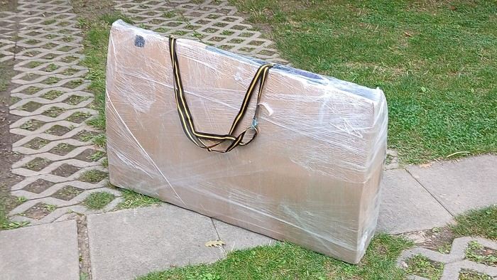
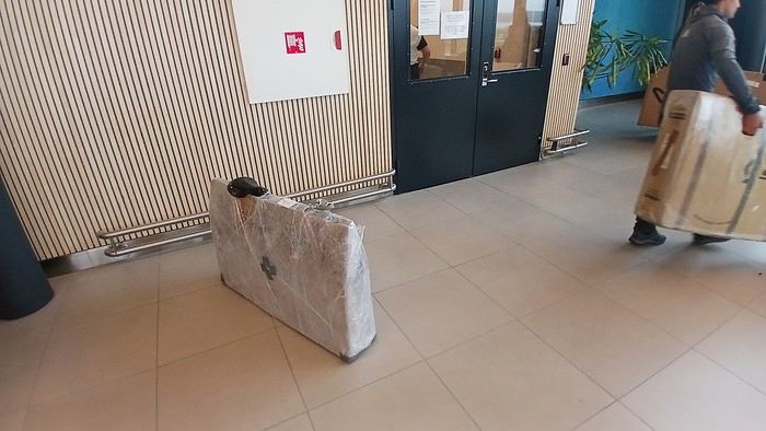
After testing it for three years across various modes of transport, I’m sharing this video of a bike packing case. It’s made from recycled cardboard and shrink-wrapped, with adjustable thickness and added bubble wrap depending on the level of protection you want.
Installing spacers at the fork and chainstays makes the packaging compact. With the fifteen-odd euros for shrink-wrapping at the airport, this case travels really well.
https://youtu.be/_GDJi-GqmkM
- Low bulk (1.10m x 0.70m x 0.25m for a large frame), it fits vertically in train luggage compartments and the total dimensions (x+y+z) don’t exceed 2.40m.
- Two carrying solutions for public transport and easy handling by airport staff (no more tears in the cardboard from openings).
- Discreet packaging when dealing with bus drivers and train conductors, as it looks like an ordinary parcel.
- No need to return to the starting point to retrieve the case from your outbound trip, which you’d otherwise have to store somewhere, or deal with a bulky cover to pack in your panniers.
- You can still check tire pressure through the plastic film without damaging the packaging too much.
Drawbacks: Around 3 hours for this lengthy and meticulous process—removing the wheels, pedals, handlebars, and derailleur without misaligning them, then securing all components to the frame.
If you get a chance to test it, send me your feedback for future improvements.
I just took a trip in Tunisia from Tozeur to Douz, skirting Chott el Jerid to the south. I’m back with the urge to keep going further south via the 4x4 tracks to connect Douz to Ksar Ghilane. Has anyone driven this route recently or explored southern Tunisia?
Thanks for your tips!
fix
😎Fellow traveling cyclists or not, all of you who love travel, the pleasure of physical effort, nature, beautiful machines, people with true passions they seek to fulfill, and who also enjoy reading great literature about all this—the *200* magazine is for you just as it is for me. I should mention I have no financial or other interest in this (in an era where we accuse our politicians of all sorts of vile interests, I prefer to take precautions). I’ve been subscribed since the beginning, and every three months, I get my 130 pages of dreams (the magazine just went from 110 to 130 pages).
It covers everything from the trans-America route to the TCR (Trans Continental Race) from Belgium to a small town in Turkey, with mind-blowing averages—4,000 km and 80,000 m of elevation gain in 8 days and 15 hours for the winner. Let that sink in, and all of it without assistance—accepting a patch could penalize you. There’s also a story about crossing Iran, encountering one of the world’s most welcoming populations, following in the footsteps of Nicolas Bouvier, as well as retirees leisurely traversing France. The common thread in all these stories? Beautiful writing. Take, for example, a stunning article: *"Passengers of the Cold: From Edinburgh to Thurso, at the very north of Scotland, 550 km of moors, coasts, and icy wind. In Thurso, the road ends at a quay, facing the Orkney Islands. We wanted a November trip, off-season. We wanted to surprise winter. Just before the snow."* A sublime piece on the experience of facing adversity and the chance encounters along the road and in the elements.
Before I embarked on my own bike trips, I dreamed a lot about them—from the Atacama to the Gobi, along the Mekong, and not forgetting France. And now, these 130 pages every quarter keep those dreamy vibes alive through stories written in the most beautiful prose.
I’ll stop here because it might sound like I’m advertising, but if you don’t know *200*, I invite you to discover it. It’ll give you wings for the most incredible challenges or simply reinforce your desire for slow rides with your eyes open to others and nature.
A little news to wrap up: Axel Carion and a friend just broke the record for crossing South America from Colombia to Ushuaia in 59 days. On its own, that doesn’t mean much, but I can’t help it—it makes me dream. You should see how he talks about it, the flashes of that wild nature he’s stored away: a snowstorm at Paso Jama and the surreal sight of the suddenly snow-covered Licancabur!
Luc
PS: The magazine is called *200* because a day’s ride starts at 200 km—well, I’ve never done a ride like that since my longest was 167 km (with 18 kg of luggage, mind you), but why not one day? The magazine will explain how to tackle your first 200, and then the question in conclusion: when will you do your first 300?😏
I’ve got my flight ticket sorted—departing in mid-November and returning in mid-March. I’ll arrive in Santiago and leave from Buenos Aires.
I’ve already been to southern Argentina, specifically Torres del Paine National Park, and I’d love to go back to do the full W trek (I only did the shorter version last time).
I also want to do some hiking and maybe even tackle a summit. I climb and occasionally do some mountaineering, so I’ll definitely be going with a guide.
I plan to start around Temuco in Chile, with the idea of heading toward the lakes, then taking the Carretera Austral.
I’m not sure if I’ll go all the way to Ushuaia—it’s supposed to not be *that* worth it, except for the bragging rights of saying you’ve been to the end of the world.
I saw there are lakes in Argentina too.
I don’t have a precise itinerary, but what I’d love is, once I reach the southernmost point of my trip, to take a mini-cruise to see some wildlife. Any tips for that?
What kind of sleeping bag did you take? Is a 0°C (32°F) one enough?
And one last question: white gas stove or can I get by with my gas stove?
I'm developing a free and open-source web app for planning walking and cycling trips (and even car trips). You can create a route by clicking directly on the map to add waypoints, and it can consist of multiple stages. The app provides tools to edit the stages and the overall route, and to display useful information (distances, altitudes, and elevation changes). A relief profile can be shown as a graph for a specific stage or the entire route.
Once the route is ready, it can be exported as a GPX file, which can then be used with a GPS or a mobile navigation app.
The app is built in JavaScript and runs entirely in the web browser. It uses the Leaflet library and several OpenStreetMap-based services. Initially developed for my personal needs (I enjoy hiking and cycle touring), I’d be happy to share it with anyone who might find it useful. It’s free to use, doesn’t require an account, and the source code is available.
hello fellow cycling enthusiasts
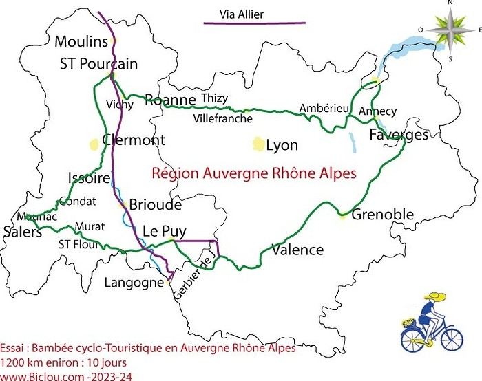
here’s a travel journal of the cycling tour through the Rhône-Alpes Auvergne region by Claudio
zouli
it was the plan
http://cbandiera.free.fr/parcours/auvergne-Ralpes/
the trip was completed
story being posted online soon
1100 km in 11 days
beautiful and varied regions
Hello,
We’d like to go on a 3- to 4-month bike trip starting in December, crossing from Assam (northeast India) to New Delhi via Nepal.
Are there routes with light traffic along the Brahmaputra and through Nepal?
We’re also looking for any info on accommodations, wild camping, local interactions, etc.
Thanks,
Michel
I’m planning to cycle from Morlaix to Brest (via Roscoff and the V45 coastal route). We’ll start riding on August 16th for 13 days (with stops for island visits, surfing, etc.). Is there a lot of traffic at this time of year? I’ve got two kids, 11 and 13, and we don’t like riding in the middle of cars (we’ve already done the Vélomaritime—Caen to Cherbourg—the Loire route from Orléans to Saumur, the Vélodyssée from Nantes to Royans, and the canals like the Nivernais and Bourgogne, where there were plenty of bike-only lanes, which isn’t the case on this route).
Thanks for your help if you’ve already done this route in late August!
Virginie
Hi there,
I’ve been road cycling for several years, and I’m about to switch to gravel in the next few days—I’m waiting for my bike, which should arrive this week.
I’m planning a bikepacking trip in a few weeks along the Véloroute V81, also known as the Vélosud, from Biarritz to Le Barcarès.
Has anyone here already done this route? Any info is welcome, whether it’s about the route itself, gear, or accommodation. I’ll prioritize staying with locals as much as possible. On that note, I just signed up for the brand-new site *Guidon et Couette* ((www.guidon-et-couette.fr)), which offers free accommodation between cyclists across the country, but there’s almost no one listed along my route!
Thanks in advance.
Laurent.
Hi there, I’m planning a cross-Canada bike trip, and I’ve got a question that might seem silly, but could someone tell me how to pack a bike (in a box, with a fragile sticker... I don’t know) for a flight? Thanks in advance!
This summer, we’re planning to cycle along the EV 19 that follows the Meuse River from Langres all the way to Rotterdam.
My question is about getting back to Nantes.
Do any of you know what the best return option might be? I’d love to hear about your experiences.
I saw that FlixBus doesn’t take bikes.
By train, I think it’s possible but would involve multiple local trains.
We were also wondering if there’s a boat from Rotterdam to Saint-Nazaire that could take passengers with bikes.
Any tips or experiences you can share would be really helpful—thanks in advance!
Have a great evening
I’ve gotten used to crossing Europe by bus to return by bike.
It was really convenient to take the bike without having to disassemble it.
But FlixBus no longer accepts bikes...
What alternatives do you know about?
Thanks.