On s'apprête a partir à partir en voyage aux États Unis au mois d'avril avec mon copain.
Nous arrivons à Los Angeles puis visite des parcs de l'ouest, Las Vegas et retour par San Francisco...
J'ai lu pas mal de choses sur les forums mais j'avoue que je n'arrive pas a trouver ce qu'il me faut...
Pensez-vous qu'il vaut mieux acheter un GPS en France avec la carte des États Unis ou une application du style CoPilot USA est suffisante ??
Merci par avance pour votre aide.....
"J'ai lu pas mal de choses sur les forums mais j'avoue que je n'arrive pas a trouver ce qu'il me faut... "
Pourtant, c'est un sujet qui revient régulièrement sur le forum😛
Oui, l'usage du Smartphone en tant que GPS fonctionne parfaitement bien (ns, ns n'utilisons que ça comme GPS, et ça fonctionne aussi bien pour la route, que pour les randos "hors des sentiers battus")
Je possède 2 versions de Copilot (Europe ouest et USA) - cette application très bon marché ( android 3.2 sur Xperia ) est efficace.
Testé 2 semaines en Espagne et 4 en Louisiane-Texas
Le seul "léger " reprocha à lui faire serait le temps de re-calcul un peu long mébon ...
Avantage certain: éviter d'acheter et de se promener avec un appareil supplémentaire + le câble qui va bien + le chargeur etc...
Bien entendu pas de roaming en déconnectant les datas pour trouver le "mexicain" le plus proche
Utile, voire indispensable dans les villes (je suis de la génération Michelin pourtant 🙂) très pratique pour trouver l'hôtel en banlieue, un resto recommandé, un garage éventuellement, un Visitor Center perdu dans le Downtown - pas du tout à Arches 😎
Franchement aucun des deux!
Je suis NULLE en orientation et pourtant je ne me suis pas perdue une seule fois!!! Une bonne carte routiere ht en france (plus pratique) suffis!
La bàs tout est simple!!! C'est nord sud est ouest! Du moment que vs savez vers quelle grande ville vs vs dirigez c'est tres bien indiquer! (Par exemple 98 west...) le numero de la route et la direction sont toujours écris a chaque intersetion!
En plus cest plus drole!!
Moi j'utilise CoPilot! Acheter 15€ pour avoir la version Canada-USA complète avec les mises à jour des cartes.
Les cartes marchent hors-ligne très bien et je n'ai pas de problème de lenteur de recalcul d'itinéraire lent.
A conseiller, sur iPhone il marche super bien!🙂
j'ai utilisé pour mon premier voyage nokia map , plutot efficace mais super long a trouver les satellite (sans doute du au telephone de l'epoque), ensuite j'ai utilisé navigon pour le 2 eme voyage , efficace , carte sympas , correct.
Pour le troisieme voyage j'ai acheté un tomtom start au walmart rapide , precis , efficace.Langue quebec pour la voix , genant au depart mais on s'y fait vite.Et puis en bricolant un peu on peut y mettre au retour les cartes europe gratuitement si on sait ou chercher.
Pour le quatrieme , je prevois de partir avec le meme tomtom et mettre navigon sur mon nouveau telephone toujours gratuit si on sait ou chercher 🙂.
Je rigole toujours quand je lis: je me suis jamais perdu meme sans GPS patatipatata j'suis le meilleur de l'orientation j'ai gagné koh lanta 50 fois 😎
Il est vrai que rouler et s'orienter et assez simple aux USA , tu veux aller à vegas ou au grand canyon tu vas y arriver assez facilement, ( encore que ....) mais trouver une adresse precise dans LA , las vegas ou meme sans francisco san GPS se n'est clairement pas possible.Exemple je demande aux gagnants, de koh lanta sans regarder de map d'aller au 3280 red rock street à las vegas , en s'aidant de son pousse pour tater le vent et en regardant le soleil bah il va chercher longtemps.
Chose que tu ne feras pas avec le GPS parce que lui il a pas gagner koh lanta mais dans sa memoire il y'a toutes les adresses du monde , se qui te permettra de trouver ton adresse a coup sur et de gagner beaucoup de temps 😎
Bonsoir,
COPILT USA fonctionne bien, mais c'est parfois long (lent), principalement en ville et on a vite fait de louper le carrefour.
Bonne application pour les balades à pieds ou bus.
Cette appli n'a pas besoin d'une conncetion web ou 3 ou 4G, uniquement le réseau mobile locale.
Mais le mieux est d'acheter sur place un gps de base (effectivement entre 60 et 100$), les cartes sont à jour et vous pouvez le revendre facilement une fois de retour en Europe.
Carte Amérique du Nord (U.S.A. et Canada) : 20Euros, mise à jours gratuite à vie. Pour système Android et de qui reste de Apple😉
Je l'ai sur ma tablette Nexus7 et ça fonctionne parfaitement.
mais trouver une adresse precise dans LA , las vegas ou meme sans francisco san GPS se n'est clairement pas possible.
Bonjour
Tu sais, il existait déjà des voyageurs avant le GPS - j'en suis un survivant ...
Je me souviens : j'éliminais les autochtones qui ne m'indiquaient pas la bonne direction 🙂 du coup j'ai gagné 100 00 € pour les voyages que j'effectue maintenant
Le GPS apporte un confort indéniable mais quand le "zinzin" plante ( code du logiciel écrit avec les pieds, nouveau quartier ou route non répertorié) .... la carte, l'habitant, le cop sont, eux, vraiment incontournables.
Je rigole toujours quand je lis: je me suis jamais perdu meme sans GPS patatipatata j'suis le meilleur de l'orientation j'ai gagné koh lanta 50 fois 😎
Il est vrai que rouler et s'orienter et assez simple aux USA , tu veux aller à vegas ou au grand canyon tu vas y arriver assez facilement, ( encore que ....) mais trouver une adresse precise dans LA , las vegas ou meme sans francisco san GPS se n'est clairement pas possible.Exemple je demande aux gagnants, de koh lanta sans regarder de map d'aller au 3280 red rock street à las vegas , en s'aidant de son pousse pour tater le vent et en regardant le soleil bah il va chercher longtemps.
Chose que tu ne feras pas avec le GPS parce que lui il a pas gagner koh lanta mais dans sa memoire il y'a toutes les adresses du monde , se qui te permettra de trouver ton adresse a coup sur et de gagner beaucoup de temps 😎
Bon vu que je suis à peu près la seule à avoir répondu "pas de GPS" je pense que ton message sympathique s'adresse à moi (entre autre) donc je tiens à signaler que je n'ai jamais prétendu être une reine de l'orientation (bien au contraire!!!!! je me rappelle avoir dit être nulle!) et encore moins avoir gagner koh lança (d'ailleurs je ne vois pas le rapport....?!? tu voulais peut être dire Pekin Express...)
Par ailleurs je suis tout à fait d'accord avec Caribou44 : je pense qu'il y avait des voyageurs bien avant qu'il n'y ai de GPS, alors si l'on suit ton raisonnement je me demande vraiment comment ces pauvres hommes de cro magnons faisaient!!!
Pour réponde à ta remarque suivante :
"Exemple je demande aux gagnants, de koh lanta sans regarder de map d'aller au 3280 red rock street à las vegas , en s'aidant de son pousse pour tater le vent et en regardant le soleil bah il va chercher longtemps."
Je dirais encore une fois : mais franchement tu crois que l'on faisait comment avant?!?! Quand on arrive dans une grande ville, n'importe quel hôtel ou office du tourisme fournissent des cartes détaillées des plans de la ville et des quartiers... en plus je reste persuadée que demander son chemin est encore une forme de communication possible entre êtres humains civilisés! et bizarrement ça permet de rencontrer des gens... surtout aux USA ou les américains sont super serviables à ce niveau (certains nous on même proposer de nous déposer ou de prendre les transports avec nous pour nous indiquer les chemins...)
C'est vrai que l'on préfère les transports en communs dans des villes comme LA ou SF... mais c'est une question de choix les deux sont possible avec ou sans GPS....
Honnêtement lors de notre deuxième voyage on avait un GPS inclus dans la loc de la voiture, on s'en est servi trois fois je pense...
Le seul moment ou j'y ai trouver un intérêt ça a été pour trouver une banque précise... et même comme ça j'aurais très bien pu demander...
Encore une fois ça n'a rien à voir avec la Fance...
Je n'ai fais que donner un avis issu de ma petite expérience.... Je peux comprendre que certains soient rassurés par un GPS... je disais juste à MimiMaster32 qu'il y avait une autre option possible!
Cependant je trouve votre état d'esprit très fermé... du genre les grand experts avec LA réponse à toutes les questions posées.... Il faut rester ouverts les amis, chacun voyage à sa manière et l'intérêt de ce forum est de pouvoir partager avec les autres diverses manière de faire, non d'en imposer une seule et unique...
non pas du tout, c'est pas forcement destiné seulement à vous il y'avait deja eu d'autres posts sur le sujet du GPS .
Bien sur il y'a eu le voyage avant le GPS et on en revanit vivant , mais en resumé le GPS fait gagné du temps et epargne le stress .
Je me souviens d'un hotel sur coigniere que j'ai mis deux heures à trouvé car il etait tres tres mal indiqué , j'aurais eu le gps je gagné 2H de mon temps et j'evite une engeulade avec ma femme 😎
Donc maintenant en voyage GGGGPPPPPPSSSSSSSSSSSSSSSSSSSSSS!!!!!!!!!!!!!
Tu sais, il existait déjà des voyageurs avant le GPS - j'en suis un survivant ...
Je me souviens : j'éliminais les autochtones qui ne m'indiquaient pas la bonne direction 🙂 du coup j'ai gagné 100 00 € pour les voyages que j'effectue maintenant
Le GPS apporte un confort indéniable mais quand le "zinzin" plante ( code du logiciel écrit avec les pieds, nouveau quartier ou route non répertorié) .... la carte, l'habitant, le cop sont, eux, vraiment incontournables.
Alain
Il n'y a rien de parfait et je suis un expert pour me débrouiller avec le repère du soleil et bien entendue les cartes . Par contre le GPS c'est le confort de se laisser guider dans les villes et profiter du paysages au lieu de se casser la tête avec les vielles méthodes.
Le voyage et beaucoup plus agréable pour le peu que ça coûte, une seule nuit d'hôtel ...Pourquoi s'en priver et puis les cartes , faut quand même les acheter. 😕
Je plussoie pour les villes et encore faut il qu'elles soient d'une importance ou d'une configuration difficiles à appréhender rapidement.... et je l'utilise sans remords ni appréhension 🙂.
Mais pour aller de Moab à Torrey, par exemple, strictement aucun intérêt d'avoir le champ de vision pollué ...
Je pense que cette nouvelle génération de voyageurs élevée au lait maternisé de chez Garmin ou Tomtom sera bien prise au dépourvu en cas de pb software ou hardware.
Je pense que cette nouvelle génération de voyageurs élevée au lait maternisé de chez Garmin ou Tomtom sera bien prise au dépourvu en cas de pb software ou hardware.
Alain
Je ne crois pas , quand on est dans la misère on trouve le moyen .
Finalement, nous avons opté pour l'achat d'un GPS Garmin Nuvi 40 dans un supermarché Wallmart en arrivant à Los Angeles. Il nous a couté 100 dollars.
Le GPS nous a été bien utile voire indispensable..... Je le conseille fortement aux personnes qui hésitent encore..
J'ai pu revendre assez facilement mon GPS en rentrant en France sur leboncoin !!
Merci à tous pour votre contribution sur ce forum et bonne route 🙂.....
Finalement, nous avons opté pour l'achat d'un GPS Garmin Nuvi 40 dans un supermarché Wallmart en arrivant à Los Angeles. Il nous a couté 100 dollars.
Le GPS nous a été bien utile voire indispensable..... Je le conseille fortement aux personnes qui hésitent encore..
J'ai pu revendre assez facilement mon GPS en rentrant en France sur leboncoin !!
Merci à tous pour votre contribution sur ce forum et bonne route 🙂.....
C'est ce que je conseille régulièrement sur le forum .
Bonjour
Mon fils (qui est un geek) ns a installé HERE MAPS sur nos portables.
L'interet est parait-il que ca n'utilise pas la liaison tel pour fonctionner, et donc que ca ne consomme pas du forfait.
Ca a tres bien marché. aucun pb particulier.
Lui se sert de sa tablette comme GPS. C'est beaucoup plus confortable car l'ecran est beaucoup plus grand.
En plus, comme il a un forfait US, avec 3 et 4G, sa tablette est reliée au tel et on peut s'en servir comme un veritable ordi.
(Notamment SKYPE : c'est bluffant de voir sa famille en France alors qu'on est en train de rouler sur l'autoroute en pleine campagne)
Nous avions utilisé Sygic sur smartphone Android lors de notre circuit de l'Ouest Américain en 2014. Impeccable et on a évité des coûts supplémentaire avec la location du véhicule. De plus, dans le véhicule loué, nous avions le gps qui fonctionnait donc...il n'était pas désactivé.
Hello everyone. After a dozen 4x4 trips to this country before COVID, I’m planning another departure at the end of 2026 and early 2027—around three weeks starting December 27th. Main goal: Merzouga to Chegaga, sand, sand, and more sand. Mostly camping and a few campgrounds here and there.
After 40 years of traveling in Morocco, I want to explore a new area by 4x4—the Western Moroccan Sahara, which I don’t know very well.
I have plenty of tracks and itineraries, but I’d love some info to help me decide on the best route:
Part 1:
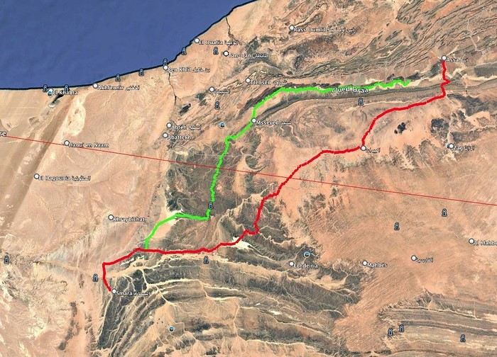
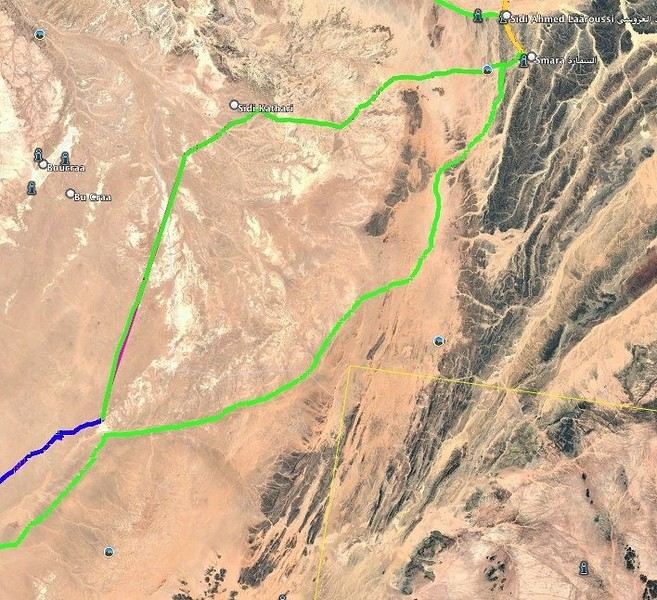
I want to do the ASSA - SMARA crossing. Basically, I have two options: the first follows the Draa River and goes through M’SIED, and the second is much further south, passing through LABOUIRAT and heading straight to SMARA.
If you have any details on road conditions, driving restrictions, etc., I’d really appreciate it.
Part 2:
SMARA - BIR ANZERANE - DAKHLA – here, I also have two routes.
The first heads west from Smara toward Sidi Kathari.
The second goes east from SMARA and gets pretty close to the border at one point (about 10 km away).
Both routes meet up about 150 km later and are nearly identical from there to BIR ANZERANE and DAKHLA.
Hi,
For next summer’s vacation, I’m thinking of returning to the Sahara after visiting Tamanrasset and the Hoggar, which was stunning—not to mention the Tuareg hospitality.
I’d like to explore the sandy desert this time since the Hoggar was 80% rocky.
So, I’m wondering which city I should prioritize if I want to go there in late July–early August for the landscapes, extreme heat, and guides offering 4x4 and camel treks. Also, if there are any recommended guides for those in the know and a decent hotel.
I’m torn between Djanet, In Salah, Adrar, Ghardaïa, and Timimoun.
I’m of Algerian origin, so no visa or other formalities to worry about.
Thanks.
Hello, I’m preparing for a Tunisia-Algeria road trip.
I need to know if we can cross the Sahara to reach Djanet and Tamanrasset by road freely,
After that, obviously off-road in the desert with a guide.
What do the authorities say?
My trip: northern and southern Tunisia, a stroll in the desert.
Crossing the Tunisia-Algeria border via the Taleb Larbi customs.
I’ve already done this route through an agency, but this time we want to do it on our own.
Then heading down to Djanet for eight to fifteen days in the desert with Mouloud, a local guide.
Direction Tamanrasset: road and tracks, the mountains of the Assekrem, the Hermitage of Père de Foucauld.
Return via the Trans-Saharan Highway.
Visit to northern Algeria, then back by boat from Oran to Spain.
Dates: late December to mid-February.
We’ve got plenty of time.
If another crew is interested, we’re already two vehicles.
Looking forward to your replies.
Hi there,
I’m planning a trip to Russia and Mongolia, starting from France.
Crossing the border at Poland/Belarus or Georgia/Russia—other borders seem either closed or complicated.
Tourist visas for 3 months with multiple entries.
Do you have any info on Russian companies that cover a 4x4 vehicle for 3 months, and what prices in rubles or euros you’ve paid?
Which bank did you use for expenses? (EuroMastercard and Visa cards no longer work.)
Regarding Russian SIM cards, a new system called "Gosuslugi" has been introduced. How long did it take you to get one, and what steps did you follow?
Hi there,
We’ll be traveling in January 2027 in a 4x4 with a rooftop tent with our three kids, from Johannesburg to Cape Town. We’ve already booked several campsites in national parks (Golden Gate / Mountain Zebra / Addo Elephant / Garden Route).
We still need to reserve the stretch between De Hoop Nature Reserve and Cape Town. Any suggestions?
We’d love to stay around Cape Town for 5 days to explore the wine route, the peninsula, and do some hikes in Table Mountain.
Any camping recommendations? Or, on the contrary, places to avoid?
Also, we have 2 nights left near Wilderness National Park / Knysna. Any recommendations?
Thanks so much for your help!
For my 60th birthday (yes, I’m jumping the gun a bit!), I’m starting to plan a self-drive trip to Tanzania (in June).
I also considered Zimbabwe but I’m worried it might be a bit chilly at night in June.
I’ve revisited an itinerary I’d thought about before, tweaking it since I’ll have more days to dedicate to this trip. Still no big northern classics for the same reasons as before (too expensive, too crowded, too many tour operators).
Here’s what I’ve got so far:
(Arrival/departure from Kilimanjaro Airport)
Night 1: Arusha
Night 2: Arusha
Night 3: Lake Manyara
Night 4: On the way to Iringa (any ideas???)
Night 5: Iringa
Nights 6–8: Ruaha NP
Nights 9–10: Mikumi NP
Night 11: Bagamoyo
Nights 12–15: Beach
Nights 16–17: Lushoto
Nights 18–19: Mkomazi NP
Night 20: Toward Marangu – eastern Kilimanjaro
Night 21: Western Kilimanjaro
End of trip
All your ideas, tweaks, info, and suggestions on this route are welcome!
I could move one beach night somewhere else if needed.
Also, if you have a car rental company to recommend or thoughts on the bandas rented in the parks, I’m all ears!
Finally, what are the roads like in Ruaha in June? The rental company I’m looking at seems to allow this park with a small 4x4. (Off-limits: Serengeti and Natron)
We’re planning a long-term trip starting in April with our 4x4, beginning in the USA.
We’re still looking for car insurance that covers Canada and the USA.
We’ve read quite a few forums, but we’re hoping for some help (from fellow travelers).
Hi,
we’re planning to visit a park again.
Could you point us toward the camps in Gonarezhou Park?
>We’re traveling completely self-sufficiently.
We love wildlife.
Thanks for any tips you can share!
JP
Hi there, we’ll be in Mozambique in early December 2026 and we’d like to travel from Vilanculos to Beira by car or bus to reach Beira airport. After that, we’re planning to visit Gorongosa National Park before flying back to France from Beira. From what we’ve heard, the road to Beira is tricky, especially at this time of year (start of the rainy season). Could anyone share their thoughts or suggest a solution? Thanks so much for your help!
Anne
Hi there,
I’m heading to Lesotho in a few days and I’m struggling to find info on the best route between Katse Dam and Sehlathebe National Park. There’s a fairly "direct" route from Thaba Tseka, but the roads seem rough, and we’re not exactly 4x4 pros. Anyone have any tips to share? Thanks!
Hi everyone,
We’re heading to Mozambique in October and are looking for either a 4x4 or 4x2 rental in Maputo, or a driver transfer option to reach:
- Ponta Do Ouro
- Tofo
- Vilankulos
The idea is to be self-sufficient for sightseeing and stops while still being able to access certain lodges or beaches that require a 4x2.
Do you have any contacts, addresses, or ideas to share?
Thanks in advance,
Hello,
We're hitting the road again in 2027 to discover new countries and cultures.
Could anyone give me some tips on driving from Ulaanbaatar to Lake Baikal and the route to take?
Thanks, and safe travels to those who are setting off!
We’re planning a 4x4 trip from Belgium to Central Asia, passing through Georgia, Russia, Uzbekistan, Kazakhstan, and Kyrgyzstan.
For these countries, our national insurance obviously doesn’t cover the vehicle, so we’ll need to get local insurance.
Will it be a problem if the vehicle is registered under person A and the national insurance is under person B? Both A and B will be in the vehicle, and both will be listed as drivers on the insurance.
When we get the local insurance, if we again list A and B as drivers, does the order matter? Could we get stuck at the border for this reason?
Hi,
For those who’ve driven on Iceland’s gravel roads in their own or a rented Duster, could you tell me what tires were fitted on the vehicle?
Were they All Terrain tires or more "standard" ones like all-season tires, for example?
Follow-up question: if they were "standard" tires, did that cause any issues on the gravel roads and rough terrain?
Thanks so much for any info you can share.
Best,
Marc
Hi there,
I'm planning a 4x4 road trip from Darwin to Broome with a rooftop tent in July 2026.
I'd like to know if I need to book overnight stops in advance or if I can just wing it and stop wherever I feel like it?
Some evenings, we'd like to stop and make use of campsite facilities (restaurant, shop, showers, toilets).
What do you recommend?
Do I need a permit?
My rough itinerary looks like this:
Darwin - Kakadu
Kakadu - Nitmiluk
Nitmiluk - Kununurra
Kununurra - Purnululu
Purnululu - El Questro
El Questro - Mt Elizabeth - Bell Gorge - Broome
I’m planning a trip to Iceland for next July-August, with a car and tent, and I’m wondering about booking campsites.
From your experience, is it necessary or even essential to book campsites in advance, or do you always manage to find a spot to pitch your tent?
We’ll also have the option to sleep in the car without pitching the tent.
Does that give us the flexibility to stay outside a campsite for a night here and there?
Hi,
I’m planning a road trip in the Middle Atlas, starting and ending in Fez and heading down to the south of Midelt, the Assoul Massif.... We’ll be traveling with two small 4x4s.
I’m looking for detailed maps of this region that include small roads and tracks.
Last year, we had a fantastic road trip in the Anti-Atlas and High Atlas using Erfahren maps, but unfortunately, they don’t cover the area we’re interested in this year.
Thanks for your suggestions!
Dominique
We’re planning a 13-day family road trip in Morocco this July, with six people in a Toyota Prado 4x4 (renting in Marrakech).
We’ll alternate between bivouacking and small hotels/riads depending on the stops.
Here’s the planned route (in this order):
Marrakech
→ Ouarzazate
→ Draa Valley
→ Zagora
→ Erg Chegaga
→ Lake Iriki
→ Foum Zguid
→ Tata
→ Tafraoute
→ Aït Mansour
→ Tiznit
→ Mirleft
→ Taroudant
→ Back to Marrakech
Our goal:
Atlas Mountains + desert + dunes + plateaus + valleys + a bit of coastline.
We’ll cover about 1,700 km in total.
We’re planning:
Bivouacking in the Chegaga/Iriki area
Flexible for the rest (booking the day before or same day)
Sand gear: traction plates, compressor, tow strap, roof rack
Questions:
Is the Zagora → Chegaga → Iriki → Foum Zguid crossing in July doable on our own (single vehicle, no guide)?
Are there any truly technical or risky sections between Chegaga and Iriki?
Does the overall itinerary seem manageable in 13 days without rushing?
Any suggestions for great bivouac spots or particularly interesting stops along this route?
The points on the route are provisional overnight stops. Some spots will include two nights in the same area.
We’re used to off-road driving, but not yet in the Moroccan desert.
Thanks in advance for your feedback and tips! 😊
Good evening
I could use some advice 🙂
Our trip to Namibia is planned for June/July 2026.
We’re struggling a bit with timing and choosing activities for the part of the trip between Sesriem and Brandberg.
Day 1: Sesriem to Mirabib
Day 2: Mirabib to Swakopmund – visit Swakopmund, overnight in Swakopmund
Day 3: Sandwich Harbour – overnight in Swakopmund
Day 4: Kayaking with the seals + the living dunes – overnight in Swakopmund
Day 5: Moon Landscape, Henties Bay + Cape Cross – overnight at White Lady Lodge in Brandberg
Does this itinerary seem realistic to you? Is Cape Cross really worth the trip? If I had to choose between Cape Cross and kayaking with the seals, which would you recommend?
Thanks in advance for your help!
Hélix
My son and I are heading to Georgia this summer to explore the High Caucasus (Svaneti, Kazbek, and Tusheti regions). For this, we’re planning to rent a 4x4.
However, the rental agencies we’ve found prohibit driving on the tracks to Omalo (Tusheti) and/or Ushguli (Svaneti).
Do you know of any agencies in Tbilisi (local and reliable) that allow rented 4x4s to drive on these tracks? If so, which ones?
Hi everyone,
I’m starting to plan an itinerary for September 2027 focused on Zimbabwe and Zambia. I’d love to visit Gonarezhou National Park—I see there are two sectors: the Mwenezi Region in the south and the area around the Runde River in the north. Should I cover both sectors or just focus on the northern region?
For the parks along the Zambezi River, is it better to visit Mana Pools on the Zimbabwe side or Lower Zambezi on the Zambia side?
Thanks in advance for any tips on the parks in these two countries.
Have a great day, everyone.
We’re spending 18 days in New Zealand from 05/04 to 05/21, arriving in QUEENSTOWN and leaving from AUCKLAND.
Any ideas for a road trip that covers the highlights of both islands but only changes hotels every 3–4 nights?
Thanks.
For our trip to Georgia in July, I’d like to rent a 4x4 starting from Tbilisi.
Do you have any rental companies to recommend?
The traditional rentals like Hertz, Avis, etc. seem way overpriced compared to local companies—what do you think? Are they properly insured?
Has anyone here tried Geo Rent Car, Auto 4 Rental, or Sur Price?
Also, I’m looking for info on the condition of the Ushguli–Lentekhi track—is it passable?
Hi everyone,
A well-prepped 4x4, a travel plan across Africa in stages since I’ve got kids to see regularly and work to earn a living.
I’m leaving in November for about a month with the goal of reaching Senegal via Mauritania. I’d love to share this trip with someone who wants to discover Mauritania and a bit of Senegal... and also experience life on board a 4x4 in the desert or bush, sometimes sleeping in the vehicle or in hostels/small hotels for comfort. I want to share this rediscovery because two’s better than one!
Just traveling, exploring, and living! !
I’m planning to explore Argentine and Chilean Patagonia for a month in December 2019.
I’m looking for a rental company (or several) that offers single-cab 4x4 pick-ups with a fitted camper cell for two people. I’m specifically after a vehicle with an indoor shower for extra comfort ;)
So, no vans—at least not from the rental companies I’ve seen so far.
While browsing the forum, I came across the Chilean rental company Holiday Rent. But do you have any recommendations for Argentine rentals?
Because, if I can’t return the vehicle in the same city as pickup, I’d prefer—and it’d likely be cheaper—to at least return it in the same country.
I’m traveling through Argentina and Chile (as well as Paraguay and Uruguay) with a 2019 Toyota Hilux Euro 6. Could anyone tell me if the local diesel is suitable for its engine, or if I need to take any special precautions (like adding an additive, for example) for these countries?
I’d also like to know if driving at high altitudes is possible, and up to what elevation—or if I should worry about the vehicle going into limp mode?
If that happens, what should I do?