Suite à un 1er voyage super dans l'ouest de la Mongolie en 2010, en couple et en autonomie, je suis en train de préparer un autre, cette fois vers le Gobi puis l'Est, pour l'été prochain.
A partir des infos du Lonely, je repère sur Google Earth les points GPS intermédiaires, mais certaines zones ne sont pas assez lisibles pour me permettre de choisir le bon intinéraire, en particulier entre Bayanlig et Kermen Tsav. Je sais que c'est faisable, puisque certains tours organisés le font.
Faut-il passer par Bayangovi et Shinejinst ? ou une piste permet-elle de descendre sud-ouest de Bayanlig à Kermen Tsav ?
Si les 2 sont possibles, quel est le mieux côté variété des paysages ? Et puis-je avoir les points gps cruciaux ? .
Ainsi que ceux des gorges de Gunii Khondii et des buttes de Yasnee Tsav...
tout d'abord quel est ton moyen de locomotion, cc ou 4x4 ? si 4x4 pas de souci, il est possible de rejoindre Bayanlig à Kermen tsav.
Autre question , as-tu un logiciel de navigation avec les cartes de Mongolie, si oui tu dois voir ( sur les cartes au 100 000e) des pistes partant de Bayanlig vers le sud-ouest.
Si non, voici un relevé te permettant de rejoindre Kermen, en passant par Bugiin Tsav et l'oasis de Zulganai . Kermen Tsav se trouvant environ 20 km plus au sud ouest de cette oasis( il y a plein de pistes allant dans cette direction)
Ainsi que ceux des gorges de Gunii Khondii et des buttes de Yasnee Tsav...
Par contre je ne connais pas les deux autres lieux cités ...
Bonjour Perju
Merci pour votre réactivité et précision !😏
Je me doutais que c'était jouable, et je vais tracer vos coordonnées.
On a un Toy KZJ .
Ces 2 sites sont indiqués dans le lonely dans ce secteur, mais sans leurs coordonnées gps !
Le 1er qui sait a gagné un yoyo en bois de Mongolie !😉
le Lonely planet parle des gorges de Khôndii à 70 km au S-O de Bayangovi ( gorges aux parois verticales). Je connais des gorges entre Altaï et Biger, très difficiles à trouver si l'on ne connait pas l'entrée, elles sont superbes !( mais elles se trouvent plus à l'Ouest de Bayangovi)
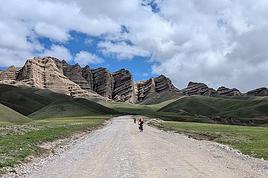
Il y a également un site superbe dans la région, à environ 60 km à l'Ouest de Kermen tsav ( 43°40.722N, 99°11.376E )
Bonsoir Perju
Merci, car j'avais vu sur Google Earth des photos de ces montagnes multicolores, mais comme elles ne sont pas toujours bien geolocalisées, j'hésitais à faire le détour. Tes coordonnées gps confirmant leur emplacement, j'envisage d'aller de Bayanhongor à Kermetn Tsav, par des pistes plus à l'ouest, en passant par Shinejinst, pour les voir
Donc, peut-être aussi prés des gorges verticales de tes photos ? As-tu gardé leurs coordonnées ?
Et sur ces pistes plus à l'ouest, je suis preneur de traces gps, ou d'infos sur la varièté des paysages, ou des pièges à éviter.
A bientôt !
bonjour,
voir ci dessous la carto au 100 000 de la zone des gorges. Le point d'entrée est assez aléatoire, il ne faut pas hésiter à suivre le début du cours d'eau qui semble mener vers rien de bien extra. Au départ on ne voit pas du tout les grandes falaises, elles apparaissent par la suite. Mais le paysage est super. Autre chose , attention en cas d'orage, en 2011 nous étions 5 voitures, les 3 premières étaient passées un soir sans problème, les deux autres restées à Altaï pour ennui mécanique, ont eu pas mal de difficultés pour nous rejoindre, l'eau (suite à un orage la nuit) était montée et ils ont dû se servir une ou deux fois du treuil pour passer. Je précise, et on le voit sur mes photos, que la veille c'était tout sec...
le point d'entrée est le 11... ensuite il suffit de suivre...
Cette gorge se trouve quelques km avant le village de Biger.
Bonjour Perju
Merci à nouveau.
On était tout prés en 2010 ! mais sans cette info.
Cette fois, on sera un peu loin.
Et j'espère que quelqu'un va m'aider à trouver cette gorge de Khundii, peut-etre prés de Shinejinst !?
bonjour,
suite à la remarque de Gaby54 ( qui doit d'ailleurs faire une erreur avec les coordonnées, car elles ne sont pas en chine..😏) j'ai voulu vérifier tout de même, et en fait les montagnes colorées se trouvent légèrement plus au sud-ouest du point que j'ai donné. Voici ci-dessous leur position exacte avec le point gps, et la trace de mon passage.
Bonsoir Perju
Ta trace vient du nord (Shinejinst ?) puis file sud-est (Kermen Tsav) .
Pourrais-tu stp me donner tes points gps (car cette zone est trés floue sur Google Earth) dans cette zone ?
A bientôt.
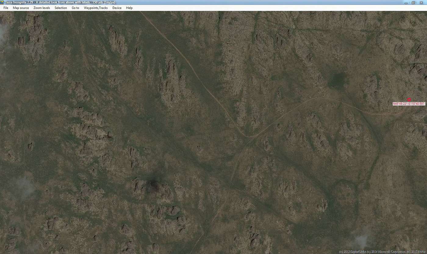
Essaie Bing Maps , très souvent d'une bien meilleur définition :voici l'endoit du wpt 11 de Perju ... mais je ne sais quel logiciel s'en sert ( à part TerraIncognita qui me permet de créer mes cartes légales...)
je ne venais pas du Nord, mais de Gurventès.
Je n'ai pas navigué avec des wp dans cette zone, j'ai suivi mes cartes et à un certain moment j'ai quitté le semblant de piste que je suivais depuis quelques heures pour remonter un lit de rivière me permettant de rejoindre la zone des montagnes colorées. Ci-joint la carte vierge et celle avec ma trace, on voit bien que je quitte la piste vers le Nord-ouest...Si tu as les cartes tu peux retrouver les wp correspondants.
Bonjour
Ouahou, effectivement, c'est plus net côté photos, et en plus, il y a davantage de pistes dessinées sur la carto.
Merci !
J'ai vu qu'en demandant des coordonnées gps, il trouve... Mais sais-tu si on peut ouvrir une fenêtre avec les coordonnées gps de la souris ?
Bonjour
Compris ! Merci.
Je n'ai pas les cartes au 1/100 000.
Mais je navigue avec un GPS Garmin, dans lequel j'ai chargé les fichiers Mongolie du CD Wold Map Garmin. Ca s'est avéré trés efficace dans l'ouest en 2010, sauf en 2 occasions, quand je me suis retrouvé avec une zone de dunes entre nous et le point où je voulais aller... d'où mes recherches anticipées cette année, afin d'avoir quelques points gps supplémentaires pour éviter les zones trop galère.
Par ailleurs, côté gaz-oil, dans ce coin, Gurvantes est indiqué.
Mais savez-vous pour Bayanlig ou Shinejinst ? ou autre dans ce secteur ?
Bonsoir
Merci à tous pour vos témoignages qui m'ont permis de fixer notre itinéraire prévisionnel de Bayanhongor à Bayandalai, et de trouver les coordonnées gps des pistes me permmettant de passer par Jinst, aiguilles de basalte, Shinejinst, les monts colorés, Khermen Tsav, Gurvantes, Sevrei, Kongoryn Els.
1 - Bon, si quelqu'un sait s'il y a vraiment du gaz-oil à Shinejinst, ca rassurerait mon épouse ! J'ai évalué environ 600 km entre les stations de Bayanhongor et Gurvantes, donc j'ai environ 200 km de marge sur des pistes correctes, mais ca me rassurerait aussi...
2 - Je suis maintenant preneur d'infos sur les sites à ne pas rater en allant plus à l'Est, et coordonnées gps.
3 - Yolin Am : y a t il encore de la glace fin juillet ? y a t il un site semblable moins fréquenté (car beaucoup de monde sur les photos Google earth... )
bonsoir,
Pas de problème pour le gasoil à Shinejinst ( arrêt en 2013), sur la photo ci-dessous tu vois que c'est un gros village.
Yolin Am : y a t il encore de la glace fin juillet ? y a t il un site semblable moins fréquenté (car beaucoup de monde sur les photos Google earth... )
Pour moi c'est décevant, rien de particulier à y voir. Par contre le passage des gorges de Dugany Am quelques km avant Yoli am( (en venant de Sevrie) est plus spectaculaire (43°29.521N 103°51.586E ). De plus en remontant ces gorges tu arrives à Yoli Am, donc autant passer par celles-ci.
Bonsoir Jean-Pierre
Bonne nouvelle pour Shinejinst. Merci.
Si je passe par Dugany Am, y a t il des possibilités de sortir de la vallée sans aller à Yolyn Am ? Et d'autres sites sympa vers l'est ?
Le passage de Dugany am est en fait en point où la gorge est très étroite.
Si tu remontes le cours d'eau ( généralement à sec) tu arrives à une bifurcation te permettant en partant sur la droite de rejoindre Yolyn am. En étant à ce point ce serait dommage de ne pas faire le crochet vers Yolyn am cela représente très peu de distance et au moins tu auras vu les deux sites intéressants du secteur.
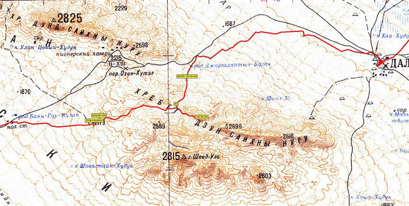
Ci- dessous la carte de mon passage en 2013, on voit bien le "crochet" pour aller voir Yolyn Am.( il y a environ 5 km). la ville que l'on devine sur la droite est dalandzadgad.
Quand je t'ai envoyé notre projet il me semble t'avoir parler de ce passage étroit (avec photo à la clé sur Google earth).
Alors il faudra que ça passe ....... 😉
Pour Garmin, je peux te conseiller de télécharger les fichiers OpenstreetMap sur la Mongolie. C'est gratuit et participatif (tu pourras envoyer tes traces).
En plus des cartes russes au 100 000 éme qui sont bonnes à 98% sauf pour les routes asphaltées qui sont nouvelles et quelques très vieilles pistes russes, j'utilise les cartes Open Street map qui ne couvrent pas tout mais lorqu'elles existent sont redoutables de précision.
Cartes russes sur Globe4X4 Globe800S avec OzieCE
Cartes Open street map sur Garmin Montana 500.
Bons préparatifs.
On se croisera peut être sur la route. Nous y sommes encore trois mois.
Bonjour
c'est sympa de t'interesser à ton tour à mes recherches !
Je viens d'essayer de comprendre OpenstreetMap Mongolie.... mais ça dépasse mes compétences en informatique...
Donc, je vais continuer à repérer sur Google Earth ou Bing, les pistes et les points gps correspondants, et de les noter pour pouvoir les rentrer sur mon Garmin au gré de notre avancée.
Bon voyage.
Bonjour à tous
Me revoici ! Plus à l'Est, entrain de chercher le gps exact de 2 sites indiqués dans le Lonely, mais sans les coordonnées gps.... Ils sont visibles sur les cartes, mais j'aimerais bien la précision de ceux qui y sont passés...
Senjit Khad (à ne pas confondre avec le Senjit Khad qui est dans l'ouest...) et Tsonjiin Chulu, au nord-est de Saynchan.
Le LP parle à propos de Tsonjiin Chuluu d'1 "ensemble évoquant des tuyaux d'orgue hexagonaux..."
Il y a une photo sur Google Earth qui semble correspondre à cette description.
Son emplacement est :
45° 58.947'N 111° 26.221'E
Bien sûr, elle peut ne pas être correctement placée.
Mais, en montrant la photo à un habitant du village de Delgerekh ( 45° 48.079'N 111° 12.650'E) ... çà devrait le faire.
extrait :
" On the way, we traveled by some natural amazing places of Mongolia, including the small rock mount of Tsonjiin chuluu which has basalt formations in the area of Delgerekh soum, Dornogobi aimag which is located at the point of N45.58.923; E111.26.172. It is an amazingly regular hexagonal columnar structure resembling 6 sided symmetrical crystals and gray colored. If it was faceting, it would be shining darkly. Local people said that there is thunderstorm not-rarely and when it has a thunderstorm, the stone would be broken. The science explained that when the basalt was in liquid, it was under the heavy pressure and it becomes polyhedron columnar structure. Tsonjiin chuluu is one of the extraordinaire natural formation and creation of Mother Nature. Although there are several such places in Mongolia, there is no any 6-sided-symmetrical-stone such as Tsonjiin Chuluu in Mongolia. Moreover, it is very rare in the world. Then we have reached to the one of 9 amazing places of Dornogobi aimag, Shiriin Chuluu at the point of N45.49.221; E110.40.597 which is located 40 km away from the soum centre of Altanshiree, Dornogobi aimag. It has a length of 15 km, and width of 2 km. As looking far from there, it looks like a threatening lion. It consists of around 10 rocks; some of them have writing on them. Since thousands years ago, Senjit khad has been disintegrating by sun and wind, and it becomes a beautiful natural rock in the world. And it has a height of 4-5 meters and a diameter of 8*10 cm."
Il y a une petite incohérence ds le texte avec les 2 noms de lieu, mais je pense que ns tenons les positions géographiques.
Merci beaucoup pour tes recherches.😉
J'étais à 2 km de Senjit Khad !
Ravi de savoir que la photo de Tsonjiin Chulu est bien geolocalisée, car il a beaucoup de photos posées à l'aveuglette !!!
Je n'ai plus qu'à trouver les pistes reliant les 2 !!!
A la prochaine !
Bonjour,
J'ai oublié de joindre la photo de l'arche Senjit Khad, la voici :
Sinon, je reviens au début de cette discussion, pourrais-tu me dire la route que tu as définie entre le canyon Khermen Tsav et le canyon coloré ( 43° 39.003'N 99° 9.756'E)?
Encore une fois , faîtes-vous plaisir !!! Pour voir tellement plus qu'avec Google Earth , utilisez les cartes de Bing Maps dans le soft gratuit TerraIncognita !
J'y vois parfaitement deux pistes qui mènent direct à ce point gps ...
Curieux , j'essaie de mettre ici une copie d'écran mais le résultat est flou , quelque soit la taille de mon image ......???
Bonjour
J'avais vu cette photo d'où ma motivation, mais merci quand même.
Voici les points que j'ai retenus sur Bing, pour prendre les pistes visibles entre les montagnes colorées et Kermen Tsav, donc dans le sens inverse de toi...
43°38.746 99°10.863 = juste au sud des montagnes colorées
43°38.491 99°10.710
43°38.414 99°11.473
43°38.271 99°11.709
43°38.016 99°13.215
43°37.283 99°14.585
43°35.510 99°16.268
43°35.089 99°16.546
43°33.800 99°21.655
43°31.922 99°25.583
43°32.096 99°31.074
43°31.644 99°39.603
43°30.260 99°45.088
43°28.742 99°47.951 = au nord-ouest de Kermen Tsav
Bon voyage.
j.utilise aussi les cartes Bing ainsi que les cartes Here.
Mais le fait est que j.aime bien avoir des points gps
desole je tape ce texte sur un telephone
cordialement
Bonjour
Mes points gps dans ce secteur sont ceux des pistes visibles, uniquement sur Bing dans ce secteur entre les montagnes colorées et Kermen Tsav.
Si tu utilises Bing, tu devrais donc les voir...
Ou peut-être es-tu déjà en route ?!
Je ne suis pas encore parti, le départ est en principe prévu le 26/05.
Le trajet pourra être suivi sur mon site grâce à une balise de géolocalisation.
J'ai reçu hier mes visas.
Es-tu sur le point de partir ?
cordialement
After 40 years of traveling in Morocco, I want to explore a new area by 4x4—the Western Moroccan Sahara, which I don’t know very well.
I have plenty of tracks and itineraries, but I’d love some info to help me decide on the best route:
Part 1:
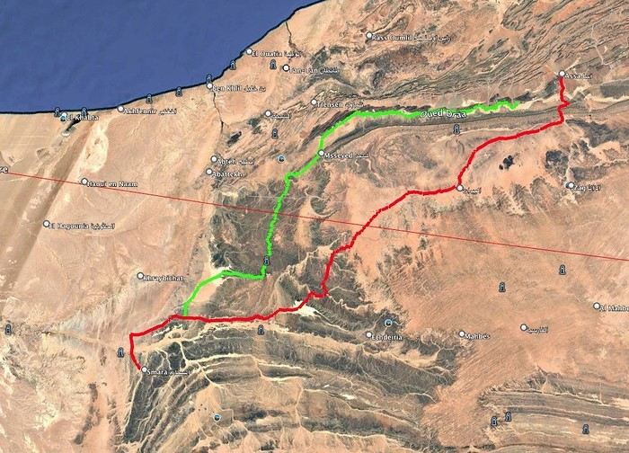
I want to do the ASSA - SMARA crossing. Basically, I have two options: the first follows the Draa River and goes through M’SIED, and the second is much further south, passing through LABOUIRAT and heading straight to SMARA.
If you have any details on road conditions, driving restrictions, etc., I’d really appreciate it.
Part 2:
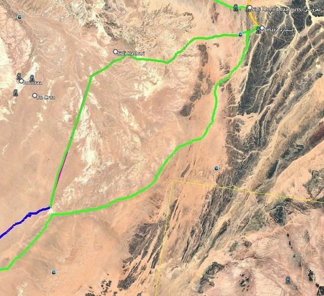
SMARA - BIR ANZERANE - DAKHLA – here, I also have two routes.
The first heads west from Smara toward Sidi Kathari.
The second goes east from SMARA and gets pretty close to the border at one point (about 10 km away).
Both routes meet up about 150 km later and are nearly identical from there to BIR ANZERANE and DAKHLA.
Hi,
For next summer’s vacation, I’m thinking of returning to the Sahara after visiting Tamanrasset and the Hoggar, which was stunning—not to mention the Tuareg hospitality.
I’d like to explore the sandy desert this time since the Hoggar was 80% rocky.
So, I’m wondering which city I should prioritize if I want to go there in late July–early August for the landscapes, extreme heat, and guides offering 4x4 and camel treks. Also, if there are any recommended guides for those in the know and a decent hotel.
I’m torn between Djanet, In Salah, Adrar, Ghardaïa, and Timimoun.
I’m of Algerian origin, so no visa or other formalities to worry about.
Thanks.
Hello, I’m preparing for a Tunisia-Algeria road trip.
I need to know if we can cross the Sahara to reach Djanet and Tamanrasset by road freely,
After that, obviously off-road in the desert with a guide.
What do the authorities say?
My trip: northern and southern Tunisia, a stroll in the desert.
Crossing the Tunisia-Algeria border via the Taleb Larbi customs.
I’ve already done this route through an agency, but this time we want to do it on our own.
Then heading down to Djanet for eight to fifteen days in the desert with Mouloud, a local guide.
Direction Tamanrasset: road and tracks, the mountains of the Assekrem, the Hermitage of Père de Foucauld.
Return via the Trans-Saharan Highway.
Visit to northern Algeria, then back by boat from Oran to Spain.
Dates: late December to mid-February.
We’ve got plenty of time.
If another crew is interested, we’re already two vehicles.
Looking forward to your replies.
Hi there,
I’m planning a trip to Russia and Mongolia, starting from France.
Crossing the border at Poland/Belarus or Georgia/Russia—other borders seem either closed or complicated.
Tourist visas for 3 months with multiple entries.
Do you have any info on Russian companies that cover a 4x4 vehicle for 3 months, and what prices in rubles or euros you’ve paid?
Which bank did you use for expenses? (EuroMastercard and Visa cards no longer work.)
Regarding Russian SIM cards, a new system called "Gosuslugi" has been introduced. How long did it take you to get one, and what steps did you follow?
Hi there,
We’ll be traveling in January 2027 in a 4x4 with a rooftop tent with our three kids, from Johannesburg to Cape Town. We’ve already booked several campsites in national parks (Golden Gate / Mountain Zebra / Addo Elephant / Garden Route).
We still need to reserve the stretch between De Hoop Nature Reserve and Cape Town. Any suggestions?
We’d love to stay around Cape Town for 5 days to explore the wine route, the peninsula, and do some hikes in Table Mountain.
Any camping recommendations? Or, on the contrary, places to avoid?
Also, we have 2 nights left near Wilderness National Park / Knysna. Any recommendations?
Thanks so much for your help!
For my 60th birthday (yes, I’m jumping the gun a bit!), I’m starting to plan a self-drive trip to Tanzania (in June).
I also considered Zimbabwe but I’m worried it might be a bit chilly at night in June.
I’ve revisited an itinerary I’d thought about before, tweaking it since I’ll have more days to dedicate to this trip. Still no big northern classics for the same reasons as before (too expensive, too crowded, too many tour operators).
Here’s what I’ve got so far:
(Arrival/departure from Kilimanjaro Airport)
Night 1: Arusha
Night 2: Arusha
Night 3: Lake Manyara
Night 4: On the way to Iringa (any ideas???)
Night 5: Iringa
Nights 6–8: Ruaha NP
Nights 9–10: Mikumi NP
Night 11: Bagamoyo
Nights 12–15: Beach
Nights 16–17: Lushoto
Nights 18–19: Mkomazi NP
Night 20: Toward Marangu – eastern Kilimanjaro
Night 21: Western Kilimanjaro
End of trip
All your ideas, tweaks, info, and suggestions on this route are welcome!
I could move one beach night somewhere else if needed.
Also, if you have a car rental company to recommend or thoughts on the bandas rented in the parks, I’m all ears!
Finally, what are the roads like in Ruaha in June? The rental company I’m looking at seems to allow this park with a small 4x4. (Off-limits: Serengeti and Natron)
We’re planning a long-term trip starting in April with our 4x4, beginning in the USA.
We’re still looking for car insurance that covers Canada and the USA.
We’ve read quite a few forums, but we’re hoping for some help (from fellow travelers).
Hi,
we’re planning to visit a park again.
Could you point us toward the camps in Gonarezhou Park?
>We’re traveling completely self-sufficiently.
We love wildlife.
Thanks for any tips you can share!
JP
Hi there, we’ll be in Mozambique in early December 2026 and we’d like to travel from Vilanculos to Beira by car or bus to reach Beira airport. After that, we’re planning to visit Gorongosa National Park before flying back to France from Beira. From what we’ve heard, the road to Beira is tricky, especially at this time of year (start of the rainy season). Could anyone share their thoughts or suggest a solution? Thanks so much for your help!
Anne
Hi there,
I’m heading to Lesotho in a few days and I’m struggling to find info on the best route between Katse Dam and Sehlathebe National Park. There’s a fairly "direct" route from Thaba Tseka, but the roads seem rough, and we’re not exactly 4x4 pros. Anyone have any tips to share? Thanks!
Hi everyone,
We’re heading to Mozambique in October and are looking for either a 4x4 or 4x2 rental in Maputo, or a driver transfer option to reach:
- Ponta Do Ouro
- Tofo
- Vilankulos
The idea is to be self-sufficient for sightseeing and stops while still being able to access certain lodges or beaches that require a 4x2.
Do you have any contacts, addresses, or ideas to share?
Thanks in advance,
Hello,
We're hitting the road again in 2027 to discover new countries and cultures.
Could anyone give me some tips on driving from Ulaanbaatar to Lake Baikal and the route to take?
Thanks, and safe travels to those who are setting off!
We’re planning a 4x4 trip from Belgium to Central Asia, passing through Georgia, Russia, Uzbekistan, Kazakhstan, and Kyrgyzstan.
For these countries, our national insurance obviously doesn’t cover the vehicle, so we’ll need to get local insurance.
Will it be a problem if the vehicle is registered under person A and the national insurance is under person B? Both A and B will be in the vehicle, and both will be listed as drivers on the insurance.
When we get the local insurance, if we again list A and B as drivers, does the order matter? Could we get stuck at the border for this reason?
Hi,
For those who’ve driven on Iceland’s gravel roads in their own or a rented Duster, could you tell me what tires were fitted on the vehicle?
Were they All Terrain tires or more "standard" ones like all-season tires, for example?
Follow-up question: if they were "standard" tires, did that cause any issues on the gravel roads and rough terrain?
Thanks so much for any info you can share.
Best,
Marc
Hi there,
I'm planning a 4x4 road trip from Darwin to Broome with a rooftop tent in July 2026.
I'd like to know if I need to book overnight stops in advance or if I can just wing it and stop wherever I feel like it?
Some evenings, we'd like to stop and make use of campsite facilities (restaurant, shop, showers, toilets).
What do you recommend?
Do I need a permit?
My rough itinerary looks like this:
Darwin - Kakadu
Kakadu - Nitmiluk
Nitmiluk - Kununurra
Kununurra - Purnululu
Purnululu - El Questro
El Questro - Mt Elizabeth - Bell Gorge - Broome
I’m planning a trip to Iceland for next July-August, with a car and tent, and I’m wondering about booking campsites.
From your experience, is it necessary or even essential to book campsites in advance, or do you always manage to find a spot to pitch your tent?
We’ll also have the option to sleep in the car without pitching the tent.
Does that give us the flexibility to stay outside a campsite for a night here and there?
Hi,
I’m planning a road trip in the Middle Atlas, starting and ending in Fez and heading down to the south of Midelt, the Assoul Massif.... We’ll be traveling with two small 4x4s.
I’m looking for detailed maps of this region that include small roads and tracks.
Last year, we had a fantastic road trip in the Anti-Atlas and High Atlas using Erfahren maps, but unfortunately, they don’t cover the area we’re interested in this year.
Thanks for your suggestions!
Dominique
We’re planning a 13-day family road trip in Morocco this July, with six people in a Toyota Prado 4x4 (renting in Marrakech).
We’ll alternate between bivouacking and small hotels/riads depending on the stops.
Here’s the planned route (in this order):
Marrakech
→ Ouarzazate
→ Draa Valley
→ Zagora
→ Erg Chegaga
→ Lake Iriki
→ Foum Zguid
→ Tata
→ Tafraoute
→ Aït Mansour
→ Tiznit
→ Mirleft
→ Taroudant
→ Back to Marrakech
Our goal:
Atlas Mountains + desert + dunes + plateaus + valleys + a bit of coastline.
We’ll cover about 1,700 km in total.
We’re planning:
Bivouacking in the Chegaga/Iriki area
Flexible for the rest (booking the day before or same day)
Sand gear: traction plates, compressor, tow strap, roof rack
Questions:
Is the Zagora → Chegaga → Iriki → Foum Zguid crossing in July doable on our own (single vehicle, no guide)?
Are there any truly technical or risky sections between Chegaga and Iriki?
Does the overall itinerary seem manageable in 13 days without rushing?
Any suggestions for great bivouac spots or particularly interesting stops along this route?
The points on the route are provisional overnight stops. Some spots will include two nights in the same area.
We’re used to off-road driving, but not yet in the Moroccan desert.
Thanks in advance for your feedback and tips! 😊
Good evening
I could use some advice 🙂
Our trip to Namibia is planned for June/July 2026.
We’re struggling a bit with timing and choosing activities for the part of the trip between Sesriem and Brandberg.
Day 1: Sesriem to Mirabib
Day 2: Mirabib to Swakopmund – visit Swakopmund, overnight in Swakopmund
Day 3: Sandwich Harbour – overnight in Swakopmund
Day 4: Kayaking with the seals + the living dunes – overnight in Swakopmund
Day 5: Moon Landscape, Henties Bay + Cape Cross – overnight at White Lady Lodge in Brandberg
Does this itinerary seem realistic to you? Is Cape Cross really worth the trip? If I had to choose between Cape Cross and kayaking with the seals, which would you recommend?
Thanks in advance for your help!
Hélix
My son and I are heading to Georgia this summer to explore the High Caucasus (Svaneti, Kazbek, and Tusheti regions). For this, we’re planning to rent a 4x4.
However, the rental agencies we’ve found prohibit driving on the tracks to Omalo (Tusheti) and/or Ushguli (Svaneti).
Do you know of any agencies in Tbilisi (local and reliable) that allow rented 4x4s to drive on these tracks? If so, which ones?
Hi everyone,
I’m starting to plan an itinerary for September 2027 focused on Zimbabwe and Zambia. I’d love to visit Gonarezhou National Park—I see there are two sectors: the Mwenezi Region in the south and the area around the Runde River in the north. Should I cover both sectors or just focus on the northern region?
For the parks along the Zambezi River, is it better to visit Mana Pools on the Zimbabwe side or Lower Zambezi on the Zambia side?
Thanks in advance for any tips on the parks in these two countries.
Have a great day, everyone.
We’re spending 18 days in New Zealand from 05/04 to 05/21, arriving in QUEENSTOWN and leaving from AUCKLAND.
Any ideas for a road trip that covers the highlights of both islands but only changes hotels every 3–4 nights?
Thanks.
For our trip to Georgia in July, I’d like to rent a 4x4 starting from Tbilisi.
Do you have any rental companies to recommend?
The traditional rentals like Hertz, Avis, etc. seem way overpriced compared to local companies—what do you think? Are they properly insured?
Has anyone here tried Geo Rent Car, Auto 4 Rental, or Sur Price?
Also, I’m looking for info on the condition of the Ushguli–Lentekhi track—is it passable?
Hi everyone,
A well-prepped 4x4, a travel plan across Africa in stages since I’ve got kids to see regularly and work to earn a living.
I’m leaving in November for about a month with the goal of reaching Senegal via Mauritania. I’d love to share this trip with someone who wants to discover Mauritania and a bit of Senegal... and also experience life on board a 4x4 in the desert or bush, sometimes sleeping in the vehicle or in hostels/small hotels for comfort. I want to share this rediscovery because two’s better than one!
Just traveling, exploring, and living! !
I’m planning to explore Argentine and Chilean Patagonia for a month in December 2019.
I’m looking for a rental company (or several) that offers single-cab 4x4 pick-ups with a fitted camper cell for two people. I’m specifically after a vehicle with an indoor shower for extra comfort ;)
So, no vans—at least not from the rental companies I’ve seen so far.
While browsing the forum, I came across the Chilean rental company Holiday Rent. But do you have any recommendations for Argentine rentals?
Because, if I can’t return the vehicle in the same city as pickup, I’d prefer—and it’d likely be cheaper—to at least return it in the same country.
I’m traveling through Argentina and Chile (as well as Paraguay and Uruguay) with a 2019 Toyota Hilux Euro 6. Could anyone tell me if the local diesel is suitable for its engine, or if I need to take any special precautions (like adding an additive, for example) for these countries?
I’d also like to know if driving at high altitudes is possible, and up to what elevation—or if I should worry about the vehicle going into limp mode?
If that happens, what should I do?
Hi there,
Can you tell me if the road between Zagora and M'Gouna is easy or difficult for a 4x4? How much time and how many kilometers should I plan for? I’m traveling in May.
Thanks!


 le point d'entrée est le 11... ensuite il suffit de suivre...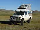




 """je découvre seulement aujourd'hui ce post, et j'ai une petite question.