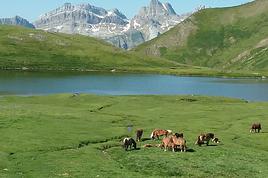
J'envisage une randonnées en bivouac dans les Pyrénées, à 2 avec mon ami, ce qui serait une surprise pour lui. Adeptes des randonnées tout les deux, nous connaissons moins les Pyrénées découvertes il y a un an lors de nos vacances. Complétement séduits par ce lieu magique, c'est dans ces coins là que je voudrais l'emmener.
Pour cela j'aurais besoin de votre aide pour m'aider a choisir le lieu précis et construire mon itinéraire. J'ai déjà lu beaucoup de messages intéressants sur ce site mais la plupart date de plusieurs années ou alors me laisse dans une vision assez vague. J'ai par exemple entendu parler du pic du midi d'Ossau qui me tente bien.
Je voudrais que l'on parte sur 5 jours en sachant que nous voyagerons en train et non en voiture pour ce qui est de l'arrivée au point de départ.
Auriez-vous une chouette idée de randonnée à me proposer, calme, sauvages, dépaysantes, le moins fréquentée possible, à faire sur 5 jours et où l'on peut faire du bivouac?
Nous sommes de très bon marcheurs adeptes des randonnées mais sont à exclure tous les itinéraires qui demandent du matériel et des technique particulières comme les cordages etc...
Nous partirions la première semaine d'Aout... Oué pas terrible pour ce qui est de la fréquentation mais pas trop le choix ;)
je refais cette annee gavarnie breche de roland et mont perdu
gavarnie breche de rolland c est dur :) mais quasi personne , il y a un passage d une 40 de minutes par l echelle des escardet ou il faut se servir de ses mains apres ca va par contre bon denivele ( c est sport ) l annee derniere au depart de gavarnie vers 8 h du mat quelques bandes de touristes ensuite personne jusqu la breche de rolland
la breche de rolland en ete c est comme une rue pietonne un jour de solde :)
passe la breche et cote espagnol y a plus personne :) calme calme calme
il y a des refuges pour nous on a dormis dans une grotte cote espagnol ,
jusqu au mont perdu ensuite i l y a encore beaucoup de marche :)
on le prevois cette annee sur 4 jours max
ossau est beau egalement :)
la mongie aussi possede qq belles rando
mais j ai quand meme un coup de coeur pour la breche de rolland malgres sa frequentation ( acces par gavarnie uniquement parceque l acces par le #parking# il y a trop de monde pour moi :)
Superbe idée, les Pyrénées possèdent de nombreux coins très sauvages avec de magnifiques lieux de bivouacs au bord de lacs ou de torrents.
Tu peux regarder mon récit de la traversée ici qui te donneras quelques idées sur les régions intéressantes
le parc national de Pyrénées est probablement l'endroit le plus fréquenté par les randonneurs en France dans les Pyrénées, si c'est le calme et la quiétude que vous recherchez en priorité, je vous deconseille le pic du midi d'ossau ou la régionde gavarnie. DOnc le premiere principe de tranquillité : fuir tout parc national qui sont des aspirateurs à touristes.
la versant espagnol des Pyrénées est moins fréquenté globalement, pour moi les parties les plus sauvages de toutes les pyrénées sont les régions du Pallars, Pallars d'Alta Aran, Pallars sobira. Pour visualiser ce sont les régions face au Couserans jusqu'en Andorre coté Espagnol. Vous n'en avez probablement jamais entendu parlé, c'est bon signe pour chercher des coins sauvages et préservés, non ? ;)
Malgré le fait qu'il puisse y avoir un peu de monde sur les chemins, les randonnées proposées précédemment dans les hautes pyrénées sont les plus interessantes au niveau dépaysement et facilité de transport: train jusqu'à Lourdes puis bus TER de la gare jusqu'à Cauterets ou plus loin. De toute facon, en dormant en altitude, vous serez tranquille parce que la majorité des gens ne viennent que pour la journée ou restent en refuges.
Attention de monter la tente au coucher du soleil et de la replier avant le lever, le bivouac est toléré mais le camping reste interdit.
je vous conseille le chemin des Bonshommes avec départ à Foix et arrivée à Ax les Thermes (Roquefixade, Montségur, Comus et Chioula).
A Montségur la visite du château s'impose, vous rencontrerez des bergers vers Comus (qui offrent parfois l'apéro !) et au Chioula vous aurez une belle vue sur la chaine ariégeoise. Enfin à Ax, vous pourrez aller vous baigner aux bains du couloubret pensez au maillot de bain ! (c 15€ les 2 heures / pers !)
Cette rando est assez tranquille mais offre des beaux panoramiques et ras pour le bivouac !
Sinon au départ d'Ax vous pouvez rejoindre Puymorens par la vallée d'Orlu, En Beys, étang du lanoux puis puymorens (en 2-3 jours)
ou alors à l'étang du lanoux direction lac des bouillouses et font romeu (4-5 jours)
ou alors d'en beys, direction les bésines puis arrivée à l'hospitalet
il y a des trains au deux arrivées
allez une dernière sur le GR10 : Luzenac - Refuge du Rulhe (par tour des montagnes d'Ax)-plusieurs boucles au départ du Rulhe - et redescente sur Merens
on a pas mal de boucles transfrontalières avec l'Andorre et depuis Merens Les Vals, il y a des jonctions
Allez sur Géoportail pour avoir une petite idée avec les cartes IGN
en autonomie (totale, ou quasi) nous avions fait un circuit intéressant en PO (cerdagne et massif du Canigou) - description et Gpx sur :
http://lethieu39.jimdo.com/randos-france/cerdagne-trek/
cartes précises utiles, voir indispensables, mais super secteur !!! accès depuis Perpignan par fer + petit train jaune pour monter à Mont-Louis ...
Bonne préparation
Merci à tous pour toutes vos infos très précieuses... Génial!!
Lethieu j'ai visité ton site et c'est très tentant. On m'a aussi parlé de Caldes de Boi côté espagnol qui semble sympas aussi. J'hésite encore mais Cerdagne semble plus sauvage et plus simple d'accès étant donné que nous allons nous rendre à notre point de départ en train et autres transports en commun ou stop etc.... et pour Caldes j'ai pas trouvé beaucoup d'info.
Je n'ai que très peu de temps pour m'en occuper, randonnée organisée en surprise pour mon ami qui en plus est en vacances en ce moment ce qui ne me facilite pas la tâche pour qu'il ne se rende compte de rien. Entre la préparation de la rando et le matos.... c'est sport... 😉
Juste une petite question, le train jaune est obligatoire pour se rendre au point de départ?
Je te remercie pour ton aide et je donnerais des nouvelles sur le lieu décidé et notre rando.
La liaison Villefranche - Vernet les Bains (fin de la ligne "normale" venant de Perpignan) jusqu'à Mont-Louis est gérée par la SNCF (train jaune ou cars ....) donc sans problème (cf site SNCF voyage) .... en plus, cette partie de ligne vaut le coup !!!
Depuis Mont Louis - La Cabanasse, il faut rejoindre l'itinéraire à St Pierre dels Forcats - Planès .....
Pour le trek : se munir d'une bonne carte et bien gérer son eau - les 2 premiers soirs, il faudra se rapprocher des sources, en contrebas de la crête et de l'itinéraire suivi .... et il faut traiter l'eau trouvée - Micropur ou autre ... (présence de troupeaux ou de familles d’isards en altitude .... c'est sympa, mais ça peut polluer !!!)
Bon trek si vous choisissez cet itinéraire
Je déconseillerai de faire ce parcours dans ce sens.
premier jour c'est un dénivellé de plus de 2000m avec la bouffe de 5j et il faut prévoir de l'eau pour quasi 1journée et demie, car c'est un parcours de crête, ( de plus le debut est très chiant puisqu'on monte à travers les pistes de ski, plus simple à faire à la descente), le premier points d'eau se situant après la crête de nuria en redescendant de celle ci pour aller sur ull de ter. Question fréquentation la crête de Nuria est une des sorties les plus connues de Catalogne, c'est donc très très fréquenté mais ça reste magnifique.
Il me parait plus judicieux de prendre le train jusqu'à la gare qui fait le changement avec le train jaune, monter sur vernet les bains en bus, puis monter sur le refuge de marialles pour récuperer l'itinéraire, et commencer par pla guilhem, cela reste engagé mais beaucoup simple à gérer que plus de 10h de rando sans eau comme première etape. ( à moins de perdre une heure à descendre de la crête pour trouver des ruisseaux ).
Mon amie et moi partons le 16 août à l'aventure dans les Pyrénées pour une randonnées d'une 12aine ou 15aine de jours en bivouac. Nous sommes à la recherche…
J'ai parcouru une bonne dizaine de sujets sur la question, et j'avoue ne pas vraiment avoir trouvé les informations que je cherchais. Je me permets donc de…
Je me permets de vous solliciter car je compte faire une rando seul en ne faisant que des bivouacs. J'aimerais y passer minimum deux nuits et maximum 5j en…
Je suis en train de préparer mes vacances d'été et je me dirai que ce serait pas mal de me faire un parcours dans les pyrénees avec tente et materiel de peche…
Je recherche quelques infos concernant la possibilité de dormir en bivouac dans les Pyrénées cet été. Nous souhaiterions partir au mois d'août sur le GR107 (de…
Bonjour,
Nous souhaitons faire le trek de 4 jours reliant Mestia à Ushguli sans agence. Il est précisé dans les descriptifs qu'il existe des hébergement à chaque étape, mais on ne trouve pas d'info sur ces hébergements. Quelqu'un a-t-il des infos et un avis sur ce parcours?
We're planning to trek in Peru and Bolivia and would love to find some local agencies.
If you know any, could you share details on prices and, of course, the names of the agencies?
Which trek would you recommend?
Elocine
Je pars en autonomie totale sur un trek au Maroc (10jrs) Imilchil - Aghbalou.
Trouve t-on des cartouches gaz à vis (Coleman, Primus) à Marrakech (adresse) ou villages entre Imilchil - Aghbalou ?
Si non , trouve-t-on des cartouches Butagaz pour camping-gaz (petit volume 230 gr ...)
Merci d' avance pour vos réponses
Hello, I’d like to embark on a little trip in my home country, Switzerland. I’ll start walking from La Cure, heading toward Le Noirmont first, then I’ll improvise my route—but it’ll probably follow the French border... at least as far as Lac de Joux.
I’ll decide day by day how much farther to go after that. My goal is to stay in nature as much as possible, wander around for as long as I can, and restock food in villages or towns along the way.
I’m thinking of mostly camping, but we’ll see if I end up in a hotel or another campsite depending on my route.
I’d love to reach La Chaux-de-Fonds on foot... maybe even Delémont.
The whole thing should take about a week, give or take.
I’ll be bringing my dog, and I’m preparing for this as soon as I’m ready.
Any tips to make sure everything goes smoothly for us? Things I should know—or avoid? What about shepherds with their flocks of sheep? And isn’t hunting season open right now?
I’m not sure if what I’m planning is even doable, which is why I’m asking around.
This’ll be my first time doing something like this—wandering in nature *and* with a dog. I’m really excited for this adventure... and I need it. Thanks!
We’re really keen on ecosystems and want to hike in "natural" ancient forests—not planted woods or areas heavily degraded by human activity. Travel guides (like Lonely Planet) don’t provide much info on this. Could you point us to the most interesting spots?
Thanks in advance for your tips.
We wish you happy holidays and a fantastic 2026, full of discoveries!
Claire and Albert
Hi, this might not be the right section, but I’d like to know if it’s possible to start mountaineering with another person without necessarily hiring a guide. We’ve done quite a bit of hiking but not mountaineering—we’ll just do a half-day glacier course. After that, we were thinking of starting with La Grande Motte and the Pointe de la Traversière, which were recommended to us. Honestly, for things like roping up and knots, I’ll learn at home with lots of videos and a book.
Hi,
I don’t know Switzerland at all and was wondering if Vallée des Joux and especially Dent de Vaulion are packed early in the morning or late in the afternoon in July and September?
If so, do you have any quieter spots to recommend in the area, or in Luxembourg (yes, I know it’s not the same country 😉)?
Thanks a lot!
I’m starting this thread—lots of travelers here have done this trek.
When RMS is mentioned, it’s this agency: Ruwenzori Mountaineering Services (with an *s*), because there’s another one online called Ruwenzori Mountaineering Service (no *s*).
Their site:
www.rwenzorimountaineeringservices.com/
From what I gather, it’s the local mountain guide agency certified by the government?
Jaimerais savoir si quelqu'un aurait fait des treks sur le Ruwenzori et combien ça coute en moyenne, les infrastructures, les paysages la sécurité sur les lieux, merci beaucoup. J'attends avec impatience vos réponses.
We’re leaving in 9 days for a two-week trip to Madeira, mainly to hike.
From my research, I’ve found that since last year, access to most trails—and systematically for the most popular ones—is now paid. You have to pay an access fee of 4.50 € per person per classified hike in 2026, and even 10.50 € for the most iconic hike: Pico Arieiro to Pico Ruivo. When paying, you also have to choose a day and a 30-minute time slot for your start time. Of course, this reservation is neither changeable nor refundable, even if the weather that day is terrible.
Personally, given the massive influx of tourists to the island in recent years, I don’t mind paying a fee to help maintain the trails. Similarly, setting a limit on the number of people who can hike them per day is certainly preferable to preserve this priceless heritage.
However, what’s much less fair is that in reality, most of the available spots are reserved: 1/ for Madeira residents (which is normal); 2/ for "economic operators" (meaning local tour operators). For example, if you’re a non-resident (independent tourist), no booking is possible for the Pico Arieiro hike for an early morning start before September! So, unfortunately, we’ll have to skip this hike.
It’s the same issue for Ponta de São Lourenço, the 25 Fontes, Pico Ruivo... in short, all the most popular hikes. Oh well, we’ll skip those too!
So my question is: which hikes do you recommend where we won’t face the huge crowds that the others get? And where we can book the day before for the next day, taking the weather into account?
Finally, a quick accommodation question: we’ve booked the first week in Funchal, but I haven’t decided yet for the second week. Do you have any advice on where to stay in the south or north, preferably avoiding overly concrete-heavy and touristy spots?
I’m reposting about the logistics for Samaria Gorge.
I’d love to get recent info, especially about whether it’s possible to park my car in Omalos, do the hike, and then catch a bus back to my vehicle.
In theory, it’s doable, but when you check the KTEL website, there aren’t any feasible schedules listed. If anyone has recently organized this with reliable, verified details, I’d really appreciate it. Thanks in advance!
Hi there,
We’re flying from Montreal to Lyon this August to go hiking in the French Alps. We’ve rented a car and will be staying at campgrounds. We’re planning to do day hikes and want to stay a few days in one spot, do a few hikes, then move on to our next camping spot. Could you share your favorite spots or any recommendations for places to spend a few days with great hikes?
A few details:
We arrive in early August and leave in early September.
We’re looking for day hikes (or shorter), moderate difficulty, with a cumulative elevation gain of no more than 1000m, and of course, beautiful scenery!
We’d prefer not to drive too much—maybe it’s best not to head too far south and deal with unnecessary heat?
Along the same lines, if you know of any great campgrounds where we can start our hike directly without needing the car, we’d love to hear your suggestions!
Bonjour
Souhaitant faire de la randonnée sur cette île, je voudrais d'abord savoir quelle serait la période la plus favorable sachant que j'avais passé quelques jours en novembre 2018 pas pour cette activité mais plus pour une simple découverte de l'île et le temps n'était pas top notamment en montagne. Donc peut on choisir une organisation en étoile sachant que je louerai un véhicule avec éventuellement 2 points d'hébergement.
Je n'envisage pas d'intégrer une structure mais de partir à 2 et de s'organiser sauf si vous me conseillez une agence locale ou un guide local. Enfin même si je compte me procurer les différents supports, carte et topo guide plus gps je vous remercie de bien vouloir me communiquer les randos à faire en priorité
Merci beaucoup pour vos informations
I’m planning to do the Mercantour crossing following the Randoxygène route in mid-July.
I’m used to hiking in the mountains, but I sometimes get vertigo, for example on ridges with drops on both sides. I wanted to check if there are any T4 or T3-T4 sections and find out if there are any very exposed passages—and if so, where—so I can plan an alternative route.
Can anyone give me some info on this?
Thanks!
I’m planning a trip around Cap Corse and the AGRIATES in 2026, from May 8th to 15th (there are still 2 spots left, by the way! Just DM me if you're interested).
I’d love to know which hikes are worth prioritizing in the AGRIATES. We’ll be staying in SALECCIA for two days as our base—what should we focus on from there?
A round trip to IGNHU beach? Any other suggestions?
For Ostricano, I think it’s too far for a round trip...
Thanks for your tips!
Have a great day,
Anie, Toulouse
I’d like to get some info about the GR10 Pyrenees traverse. I need help planning the daily stages and accommodations—my wife isn’t an experienced hiker but walks a lot, so I’d like to schedule shorter walking days and thus a longer overall trip in terms of number of days.
Could anyone give me some help and advice?
Best regards,
New to this forum, I’m planning a pretty big project for 2028.
I’m heading to Nepal to do a trek from Kathmandu all the way to Everest Base Camp (a cool 5,300 m 😄).
This trek is a bit special because even though I’ll be part of a group, I’m going solo (so far, no problem—I’m used to it). But it’s my first real trek, and it’s also a humanitarian one: once I reach base camp, I’ll stay an extra week to help clean up the waste left by tens of thousands of climbers! Since I’m originally from South America, from two countries that share the Andes, I have a deep respect for mountains—they fascinate me. So Everest… it’s kind of the trip of a lifetime!
So, a little question for those who’ve done treks to Everest before… any tips for good mental preparation (I’m already working on the physical side)?
Hi there, I’m planning the Annapurna Circuit for March 2027 and I’m looking for a local agency with a local guide—preferably French-speaking—to arrange this trek for us. Any suggestions? Thanks
Hello!
We’re spending a few days in Toraja country at the end of May. We’d love to do a day trek—taking our time—on a route that’s stunning in terms of scenery, but not a level 5 in difficulty!
Any suggestions you can share, please?
Thanks in advance
I’d like to do the Mare a Mare Sud in May over 4 days. I’ve found quite a few places to stay along the route, but I’m stuck on the start and finish.
I’ll be arriving by plane on Sunday evening and would like to start pretty early on Monday morning. Ideally, accommodation right at the trailhead (Alzu di Gallina) would be amazing, but I can’t find anything. Any tips?
Also, for the transfer from Figari Airport to Porto Vecchio or Alzu di Gallina?
At the end, I’d like to pick up a rental car—any advice on that too?
I’m traveling solo by plane to Catania in May and plan to hike the northern side of Etna, starting from Linguaglossa where I’ll arrive by bus. After that, I’d love some info on how to get up to Piano Provenzana (shuttles or hitchhiking), since it seems there’s no public transport except in the summer. Can you sleep there in a free or cheap refuge, or camp? And how far up can you go without having to hire a guide? Thanks in advance. Bernard.
Bonjour a tous,
je pars en voyage au Maroc en aout et nous allons commencer par nous arrêter a Chefchaouen(nous sommes en voiture).
Ma question: quelqu'un peut il m'indiquer un itinéraire de rando en boucle d'entre 5 et 7 jours aux départ de Chefchaouen dans le parc de Talassemtane passant si possible par le pont de dieux?Ou un guide papier qui en reunis quelques uns?
Nous privilégions le camping sauvage et les gites.
Merci d'avance
Hi there, for those who’ve been recently—is it possible to find other solo travelers in March on the island to share transport or room costs? It doesn’t seem easy to travel on a budget.
If you have any recommendations for simple lodgings or places with dorms, I’d love to hear them.
For those who’ve done multi-day treks while moving around: do you need to bring your own sleeping bag? I’d love to hear about itineraries you’ve done without a guide, just with a map and GPS.
Thanks, and have a great day!
Hi everyone!
We’re planning a 15-day road trip to Scotland this summer, specifically to explore and hike on Lewis and Harris—places we’ve never been before. We’ve visited other islands on previous road trips in Scotland (we usually go in April for a week). This would be our first time in Scotland in the summer and for 15 days. We’re looking at late August to early September.
I’m currently drafting the itinerary. We’d be crossing from Ullapool and were thinking of spending 3 nights on Harris and 4 nights on Lewis.
Does that sound balanced to you? Is it better to keep the same accommodation on Harris and the same on Lewis to explore the area? I’d love to hear about any past experiences you’ve had on these islands.
Thanks!
Hi there, I’m trying to leave for 15 days very soon to São Vicente. I’m either looking to join an agency or figure things out on my own to go hiking on one of these islands or both. From what I’ve seen, it’s not easy to organize with local transport, so it gets expensive. Can I use the services of a small local agency? I’m looking for the simplest way to hike for several days. Also, how do you get from São Vicente to São Nicolau? Thanks in advance and have a great day!
Aichatou
I’ve been wanting to do this for several years, and this year’s the one. Next September, I’ll be trekking in Tusheti (Georgia), from Omalo to Shatili.
Of course, I won’t be renting a vehicle that’d just sit unused. No problem getting to Pshaveli, but from there to Omalo, it’s a dirt road (still the case?)
There must be some form of public transport since there are so many guesthouses, and not all travelers come in a 4x4.
If any of you have been to Omalo, could you confirm that these shared transports exist and how often they run?
we’re planning a trip to Yellowstone and hoping to do a three-day backcountry hike if we get a permit.
if any of you have done this before, could you let me know if it’s possible to find water along the way? And if we can transport it, are we allowed to use a stove?